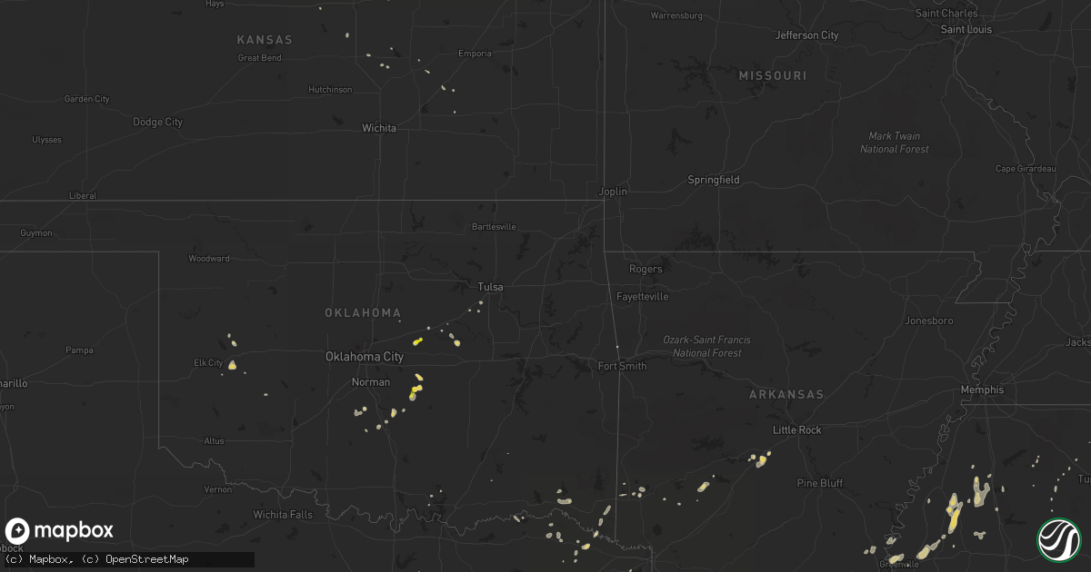
Hail Map on July 11, 2013
Get this storm
July 11 map
$229
one time, instant access
Download today. No call, no setup
Keep the $229
Bought the map and want the full workflow? Apply the entire $229 to a subscription within 7 days. None of it is wasted.
Every map, not just this one
This buys you this map. Subscription and you get every map we run, in the markets you choose from a few cities to whole states to nationwide. Plus real-time alerts the moment a storm fires.
Contact data
Name, contact info, occupancy, even credit band for addresses in the footprint. You go from where it hit to who to call.
Become the source they trust
Unlimited branding weather history reports on demand. You already have the documented answer ready for the property owner, and you are the one who showed up with it.
Property data and RoofTrace estimates
Pull up any address you have got, its value and the exact code rules for that jurisdiction, straight from One Click Code. Then RoofTrace estimates the squares, pitch, and roof value, priced the way you price.
States Impacted by Hail Map on July 11, 2013
Storm reports
North Dakota
| Date | Description |
|---|---|
| 07/11/20136:02 PM CDT | A local report indicates 67 MPH wind near 1 ENE BEACH |
| 07/11/20136:00 PM CDT | A local report indicates 60 MPH wind near 7 NE SKAAR |
| 07/10/20138:02 PM CDT | Also had about 3 minutes of pea hail. |
| 07/10/20137:35 PM CDT | Late report. Hail lasted seven minutes. |
| 07/10/20137:35 PM CDT | A local report indicates 1.75 inch wind near 7 NW RAY |
| 07/10/20137:33 PM CDT | Winds began with gust front ahead of rainfall and continued until heavy rain ended. Measured sustained 75 mph gusts to 80 mph. |
Alabama
| Date | Description |
|---|---|
| 07/11/20136:45 PM CDT | 4 inch diameter tree branch fell on vehicle causing minor damage. |
Oklahoma
| Date | Description |
|---|---|
| 07/11/20136:00 PM CDT | Strong thunderstorm wind damaged two barns and snapped large tree limbs. |
| 07/11/20135:27 PM CDT | Estimated at 54 truckstop |
| 07/11/20134:15 PM CDT | A local report indicates 63 MPH wind near 4 WNW BESSIE |
| 07/11/20134:13 PM CDT | Large trees down in haworth... Est wind gust 83 mph |
| 07/11/20134:02 PM CDT | Power poles down. Two and one half foot diameter tree blown ower. |
| 07/11/20133:55 PM CDT | A local report indicates 58 MPH wind near 10 ENE WILLOW |
| 07/11/20133:55 PM CDT | A local report indicates 60 MPH wind near 4 WNW BESSIE |
| 07/11/20133:50 PM CDT | A local report indicates 69 MPH wind near 4 WNW BESSIE |
| 07/11/20133:45 PM CDT | A local report indicates 72 MPH wind near 4 WNW BESSIE |
| 07/10/20137:35 PM CDT | Tree blocking road on hwy 18b at 4w of intersection of 18 and 18b. |
| 07/10/20137:25 PM CDT | A local report indicates 1.00 inch wind near 4 WSW SPARKS |
Connecticut
| Date | Description |
|---|---|
| 07/11/20137:18 AM CDT | Trees and wires were reported down blocking the roadway at 6 bonnie brook lane. |
| 07/11/20137:10 AM CDT | A wire was reported down blocking the roadway at the intersection of evergreen avenue and compo road north. |
Wyoming
| Date | Description |
|---|---|
| 07/11/20134:30 AM CDT | Farmers noticed after very heavy rain notice 16 rea poles were snapped. |
Virginia
| Date | Description |
|---|---|
| 07/10/20139:19 PM CDT | Tree down blocking both lanes near intersection of braddock rd and pleasant valley rd |
Montana
| Date | Description |
|---|---|
| 07/11/20135:50 PM CDT | Also reported 0.27 of rain |
Tennessee
| Date | Description |
|---|---|
| 07/11/20136:25 PM CDT | Power lines down across ardmore ridge road in ardmore with power out in town. Report via whnt-tv twitter. |
South Dakota
| Date | Description |
|---|---|
| 07/10/20138:28 PM CDT | Time estimated |
Louisiana
| Date | Description |
|---|---|
| 07/11/20136:55 PM CDT | Hail 2 east of chatham |
| 07/11/20134:13 PM CDT | A couple trees were blown down on hwy 4 and on riser rd...damage was s to se of winnsboro. |
| 07/11/20134:08 PM CDT | Roof damage to a house. |
| 07/11/20133:55 PM CDT | Numerous trees and power lines down in plain dealing. |
| 07/10/20139:55 PM CDT | Trees down from keachie to frierson |
| 07/10/20139:35 PM CDT | A 6 inch diameter tree limb was blown down on hedges drive. Other smaller limbs were blown down as well. Wind estimated at 50 mph with the passage of a strong gust fron |
| 07/10/20139:30 PM CDT | Trees down south shreveport near dixie garden... Lsus... Youree drive... Southern trace |
| 07/10/20139:25 PM CDT | Trees and power lines down on mcdaniel street near north market. |
| 07/10/20139:10 PM CDT | Trees and power lines down all over parish |
| 07/10/20138:50 PM CDT | Trees down parish wide |
| 07/10/20138:30 PM CDT | Trees down all over northern half of parish |
| 07/10/20138:15 PM CDT | Trees down in homer and e of homer on hwy 519 |
| 07/10/20137:50 PM CDT | Trees down on all major roads parish wide |
| 07/10/20137:42 PM CDT | Tree down and power out in area |
| 07/10/20137:40 PM CDT | Tree down and power out in area |
| 07/10/20137:37 PM CDT | Power lines down... Power out |
Mississippi
| Date | Description |
|---|---|
| 07/11/20136:30 PM CDT | A tree and a power line down along money rd. |
| 07/10/20138:00 PM CDT | Occurred on carol st. |
| 07/10/20137:40 PM CDT | Tree and a power line down. Tree was on fire. |
Texas
| Date | Description |
|---|---|
| 07/11/20136:55 PM CDT | Trees down on fm 134 near the jonesville community. |
| 07/11/20136:15 PM CDT | Numerous trees down and power lines down... Power out |
| 07/11/20135:50 PM CDT | Trees down and power out all over the area |
| 07/11/20135:45 PM CDT | Trees down and power out in area |
| 07/11/20135:30 PM CDT | Trees down and power out |
| 07/11/20134:45 PM CDT | Multiple trees snapped at trinity park in fort worth. Time estimated from radar -- delayed report |
| 07/11/20132:15 PM CDT | A local report indicates 1.50 inch wind near LINDALE |
| 07/11/20132:15 PM CDT | Heavy rain also |
| 07/10/20137:00 PM CDT | Tree down 2 miles south of i20 on farm road 9... Numerous limbs down |
| 07/10/20137:00 PM CDT | Roof blown off of a building into some nearby power lines on south lake street at highway 80. |
North Carolina
| Date | Description |
|---|---|
| 07/10/20139:05 PM CDT | Observed along causby road in glen alpine |
Arkansas
| Date | Description |
|---|---|
| 07/11/20135:30 PM CDT | A 300 foot section of a roof from a chicken house was torn off on boyd road in the center point community. Trees down on several county roads throughout central howard |
| 07/11/20135:30 PM CDT | A shop was damaged on mount pleasant drive from thunderstorm wind gusts. |
| 07/11/20135:30 PM CDT | Tree down in center point... Ar |
| 07/11/20135:30 PM CDT | Tree down 2 north of nashville |
| 07/11/20135:25 PM CDT | A radio tower was downed onto a fire station. |
| 07/11/20133:05 PM CDT | 6-7 trees down... Power out west side of town |
| 07/10/20139:54 PM CDT | Multiple trees down on power lines all around hamburg. Several trees also fell on homes in the area. |
Florida
| Date | Description |
|---|---|
| 07/11/20135:35 PM CDT | Broadcast media relayed report of trees down on at least 4 different homes along 118th street on the jacksonville westside with one tree on a car. No injuries were repo |
| 07/11/20135:30 PM CDT | A storm spotter and the 911 center reported trees and wires down around the 5500 block of 118th street. Time estimated by radar. |
| 07/11/20134:05 PM CDT | Nws employee reported 2 fence segments blown over in her yard in melbourne. Time estimated by radar. |
| 07/11/20134:05 PM CDT | Nws employee reported 2 fence segments blown over in her yard. Time estimated by radar. |
Utah
| Date | Description |
|---|---|
| 07/11/20136:20 PM CDT | Arrowhead summit...snd |
Cities Impacted by Hail Map on July 11, 2013
- Tecumseh, OK
- Macomb, OK
- Maud, OK
- Tutwiler, MS
- Lordsburg, NM
- Animas, NM
- Kinston, NC
- Dover, NC
- Gilbert, LA
- Winnsboro, LA
- Cartwright, ND
- Charleston, MS
- Minter City, MS
- Jefferson, TX
- Karnack, TX
- Leland, MS
- Indianola, MS
- Dubach, LA
- Rohwer, AR
- Benoit, MS
- Lindale, TX
- Tyler, TX
- Evergreen, CO
- Grand Saline, TX
- Bastrop, LA
- Mount Pleasant, TX
- Kingston, OK
- Sulphur Springs, TX
- De Queen, AR
- Dierks, AR
- Bivins, TX
- Ida, LA
- Vivian, LA
- Pikeville, KY
- Arthur City, TX
- Sumner, TX
- Booneville, MS
- Mount Vernon, TX
- Colorado City, AZ
- Detroit, TX
- Eros, LA
- West Monroe, LA
- North Rim, AZ
- Ruston, LA
- Foss, OK
- Brownsboro, TX
- Chandler, TX
- Ben Wheeler, TX
- Drew, MS
- Benton, AR
- Pickton, TX
- Saltillo, TX
- Haworth, OK
- Ray, ND
- Tioga, ND
- Hillsboro, KS
- Wibaux, MT
- Dickinson, ND
- Manning, ND
- Traskwood, AR
- Hamburg, AR
- Wildrose, ND
- Crossett, AR
- Lake Charles, LA
- Hackberry, LA
- Sulphur, LA
- Alexander, ND
- Bristow, OK
- Depew, OK
- La Fayette, GA
- Rock Spring, GA
- Chickamauga, GA
- Valliant, OK
- Garvin, OK
- Abbeville, MS
- Crenshaw, MS
- Malvern, AR
- Lindsay, OK
- Wanette, OK
- Epping, ND
- Williston, ND
- Buckhorn, NM
- Oxford, MS
- Oakland, MS
- Five Points, TN
- Asher, OK
- Homer, LA
- Foster, OK
- Cedar Point, KS
- Winona, TX
- Dunnellon, FL
- Castle, OK
- Okemah, OK
- Lisbon, LA
- Summerfield, LA
- Haynesville, LA
- Blue Springs, MS
- Chandler, OK
- Meeker, OK
- Shawnee, OK
- Earlsboro, OK
- Prospect, TN
- Ardmore, TN
- Pulaski, TN
- Dermott, AR
- Watford City, ND
- Annona, TX
- Clarksville, TX
- Okolona, AR
- Plain Dealing, LA
- Chatham, LA
- Edgewood, TX
- Heflin, LA
- Pontotoc, MS
- Newcastle, WY
- Waskom, TX
- Canton, KS
- Jackson, LA
- Ethel, LA
- Bushnell, FL
- Solomon, KS
- Abilene, KS
- Celina, TX
- Prosper, TX
- Tuscumbia, AL
- Wayne, OK
- Byars, OK
- Bailey, CO
- Medora, ND
- Jasper, TX
- Van Buren, AR
- Amity, AR
- Delight, AR
- Carney, OK
- Ecru, MS
- Farmerville, LA
- Montrose, AR
- Halliday, ND
- Taylor, ND
- Scobey, MS
- Tillatoba, MS
- Naples, TX
- Greenville, MS
- Dallas, TX
- Richardson, TX
- Plano, TX
- New Cambria, KS
- Thoreau, NM
- Dubberly, LA
- Fruitvale, TX
- Sentinel Butte, ND
- Vardaman, MS
- Hollandale, MS
- Silver City, NM
- White Earth, ND
- Corinth, MS
- Stroud, OK
- Frankewing, TN
- Pine Grove, LA
- Van, TX
- Avery, TX
- Jonesboro, LA
- Town Creek, AL
- Moulton, AL
- Mount Hope, AL
- Lockesburg, AR
- Loxahatchee, FL
- Nashville, AR
- Lindsborg, KS
- Marietta, TX
- Sparks, OK
- Bernice, LA
- Sapulpa, OK
- Butler, OK
- Vance, MS
- Sumner, MS
- Kenefic, OK
- Grand Chenier, LA
- Omaha, TX
- Dike, TX
- Big Sandy, TX
- Hawkins, TX
- Schlater, MS
- Madill, OK
- De Kalb, TX
- Belfield, ND
- Russellville, AL
- Red Bay, AL
- Lumberton, NC
- Paoli, OK
- Mountain View, OK
- Lake Panasoffkee, FL
- Cordell, OK
- Purcell, OK
- Batesville, MS
- Clinton, OK
- Holcomb, MS
- Greenwood, MS
- Carrollton, MS
- Atlanta, TX
- Bogata, TX
- Clinton, LA
- Pope, MS
- Lambert, MS
- Enid, MS
- Calhoun, LA
- Eureka, KS
- Maud, TX
- Linden, TX
- Newellton, LA
- Slaughter, LA
- Pauls Valley, OK
- Hardeeville, SC
- Rufe, OK
- Fort Towson, OK
- Shaw, MS
- Doddsville, MS
- Sheffield, AL
- Muscle Shoals, AL
- Conifer, CO
- Como, TX
- Randolph, MS
- Ruleville, MS
- Huttig, AR
- Dill City, OK
- Tolley, ND
- Crockett, TX
- Vina, AL
- Gladstone, ND
- Bagwell, TX
- Baskin, LA
- Kellyville, OK
- Lulu, FL
- Simsboro, LA
- Marion, KS
- Grambling, LA
- Courtland, MS
- Kenmare, ND
- Powers Lake, ND
- McGehee, AR
- Rienzi, MS
- Arnegard, ND