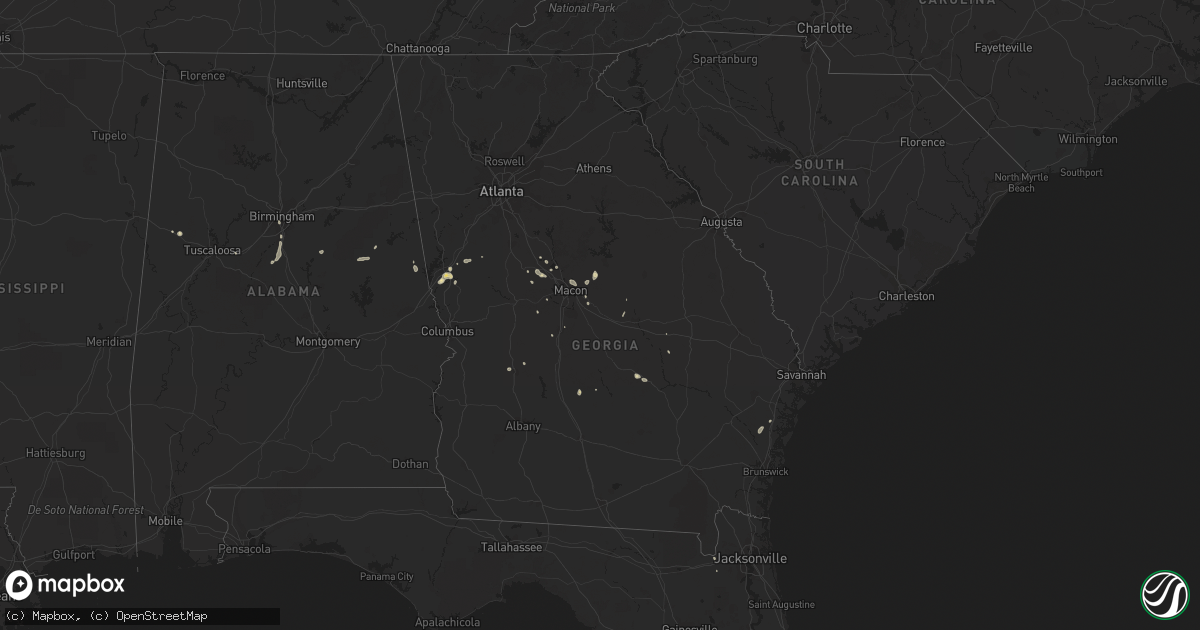
Hail Map in Georgia on July 10, 2015
Get this storm
July 10 map
$229
one time, instant access
Download today. No call, no setup
Keep the $229
Bought the map and want the full workflow? Apply the entire $229 to a subscription within 7 days. None of it is wasted.
Every map, not just this one
This buys you this map. Subscription and you get every map we run, in the markets you choose from a few cities to whole states to nationwide. Plus real-time alerts the moment a storm fires.
Contact data
Name, contact info, occupancy, even credit band for addresses in the footprint. You go from where it hit to who to call.
Become the source they trust
Unlimited branding weather history reports on demand. You already have the documented answer ready for the property owner, and you are the one who showed up with it.
Property data and RoofTrace estimates
Pull up any address you have got, its value and the exact code rules for that jurisdiction, straight from One Click Code. Then RoofTrace estimates the squares, pitch, and roof value, priced the way you price.
Storm reports in Georgia
Georgia
| Date | Description |
|---|---|
| 07/10/20155:55 PM CDT | The telfair county 911 center reported two trees down along industrial blvd and oak street. |
| 07/10/20154:30 PM CDT | Amateur radio operator reported a large tree limb over the road at highway 18 near lee king road and another tree down on highway 87 near mile marker 10. |
| 07/10/20153:40 PM CDT | The twiggs county 911 center reported two trees down along bullard road. |
| 07/10/20153:27 PM CDT | Broadcast meteorologist received report from public of trees down in bibb and jones counties...mostly along graham road. Heaviest tree damage was across jones county. |
| 07/10/20153:06 PM CDT | Tree down on interstate 95 northbound near mile marker 79 |
| 07/10/20152:58 PM CDT | 911 call center received report of trees down near hogansville rd and patillo rd...hines rd...whitesville st in the 400 block...and on interstate 185 at interstate 85. |
| 07/10/20152:53 PM CDT | The laurens county 911 center reported one tree down along old hawkinsville road. |
| 07/10/20152:50 PM CDT | A johnson county official reported a few trees down in the northeast part of the county. |
All States Impacted by Hail Map on July 10, 2015
Cities Impacted by Hail Map on July 10, 2015
- Oxford, NE
- Edison, NE
- Circle, MT
- Wolf Point, MT
- Claude, TX
- Curtis, NE
- Maxwell, NE
- Riverton, NE
- Lordsburg, NM
- Cohagen, MT
- Waldo, KS
- Russell, KS
- Paradise, KS
- Brownfield, TX
- Saint Francis, SD
- Las Cruces, NM
- McCook, NE
- Maywood, NE
- Stockville, NE
- Milledgeville, GA
- Elgin, NE
- Petersburg, NE
- Valentine, NE
- Lecanto, FL
- Five Points, AL
- Liberty, KY
- Brusett, MT
- Cambridge, NE
- Reform, AL
- Bertrand, NE
- Smithfield, NE
- Andersonville, GA
- Naponee, NE
- Wilcox, NE
- Elk Horn, KY
- Dagmar, MT
- Holdrege, NE
- Hildreth, NE
- Republican City, NE
- Orleans, NE
- Alma, NE
- El Paso, TX
- Levelland, TX
- Ingomar, MT
- McRae Helena, GA
- Dry Branch, GA
- Dodge, NE
- Davis, WV
- Mount Storm, WV
- Maysville, WV
- Petersburg, WV
- Cabins, WV
- Thedford, NE
- Deming, NM
- Cloudcroft, NM
- Haddock, GA
- Gordon, GA
- Angela, MT
- Crystal River, FL
- Beverly Hills, FL
- Mathias, WV
- Burwell, NE
- Gay, GA
- Huttonsville, WV
- Valley Head, WV
- Webster Springs, WV
- Pickens, WV
- Monterville, WV
- Welch, TX
- Naples, FL
- Beaver, PA
- Arapahoe, NE
- Beaver City, NE
- Orma, WV
- Rosedale, WV
- Shock, WV
- Fort Bliss, TX
- Canfield, OH
- Johnstown, CO
- Milliken, CO
- Seville, OH
- Baker, WV
- Grafton, WV
- Bridgeport, WV
- Duncan, AZ
- Grenora, ND
- Quemado, NM
- Sewickley, PA
- Diana, WV
- Erbacon, WV
- Cowen, WV
- Flatwoods, WV
- Hacker Valley, WV
- Ireland, WV
- Sutton, WV
- Lebanon, NE
- Hendley, NE
- Wilsonville, NE
- Roswell, NM
- Moorefield, NE
- Bartley, NE
- Johnstown, NE
- Culbertson, NE
- Emporia, KS
- Olpe, KS
- Hamilton, KS
- Virgil, KS
- Madison, KS
- Burlington, KS
- Jordan, MT
- Magdalena, NM
- Ewing, NE
- Bartlett, NE
- Redrock, NM
- Buckhorn, NM
- Wood Lake, NE
- Silver City, NM
- Amelia, NE
- Gonzales, LA
- Glendale, KY
- Sonora, KY
- Capitan, NM
- Oakesdale, WA
- Eustis, NE
- Elwood, NE
- Cozad, NE
- Lexington, NE
- Wyola, MT
- Townsend, GA
- Cottonwood Falls, KS
- Harmony, PA
- Fombell, PA
- Mule Creek, NM
- Greensburg, KY
- Natoma, KS
- Lagrange, GA
- Bowden, WV
- Red Creek, WV
- Hendricks, WV
- Anthony, FL
- Coraopolis, PA
- Chambers, NE
- Indianola, NE
- Danbury, NE
- La Mesa, NM
- Anthony, NM
- Canutillo, TX
- Santa Teresa, NM
- Truth Or Consequences, NM
- Andrews, TX
- West Point, GA
- Sarasota, FL
- Decker, MT
- Lodge Grass, MT
- Forsyth, MT
- Pittsburgh, PA
- Williston, FL
- Albion, NE
- Forsyth, GA
- Newman Grove, NE
- Holbrook, NE
- Trenton, NE
- Carpenter, WY
- Hanover, NM
- Twin Falls, ID
- Big Clifty, KY
- Eastview, KY
- Greenville, GA
- Hogansville, GA
- Inverness, FL
- Dublin, GA
- Crookston, NE
- Hernando, FL
- Dunnellon, FL
- Americus, GA
- Glenfield, ND
- Bassett, NE
- Lame Deer, MT
- Osborne, KS
- Aliquippa, PA
- Hooper, NE
- Spencer, WV
- Rochelle, GA
- Pitts, GA
- Berlin Center, OH
- Salem, OH
- Westmoreland, TN
- Yakima, WA
- Cubero, NM
- Pelham, AL
- Alabaster, AL
- Montevallo, AL
- Hysham, MT
- Ashland, AL
- Millerville, AL
- Goodwater, AL
- Dryfork, WV
- Wardensville, WV
- Lost City, WV
- Bancroft, ID
- Safford, AZ
- Abernathy, TX
- Bailey, CO
- Pine, CO
- Sundown, TX
- Lizella, GA
- Gordo, AL
- Toomsboro, GA
- Gassaway, WV
- Frametown, WV
- Lubbock, TX
- Kress, TX
- Burbank, OK
- Ainsworth, NE
- Medicine Lake, MT
- Strong City, KS
- Elmdale, KS
- Macon, GA
- Gray, GA
- Youngstown, OH
- Trenton, FL
- Bayard, NM
- Arlington, NE
- Ropesville, TX
- Cedar Island, NC
- Heppner, OR
- Moorefield, WV
- Brockway, MT
- Tilden, NE
- Oakdale, NE
- Fort McCoy, FL
- Mount Sherman, KY
- Buffalo, KY
- Campbellsville, KY
- Marion, KS
- Freedom, PA
- Rochester, PA
- Juliette, GA
- Cedar Point, KS
- Hartford, KS
- Chiefland, FL
- Montville, OH
- Huntsburg, OH
- Circleville, WV
- Helvetia, WV
- Mill Creek, WV
- Durbin, WV
- Bartow, WV
- Marble Hill, MO
- Bloomfield, MO
- Puxico, MO
- Morenci, AZ
- Reserve, MT
- Perry, GA
- Homestead, MT
- Brockton, MT
- Clearwater, NE
- Platte, SD
- Uniontown, WA
- Cody, NE
- New Brighton, PA
- Jacksonville, FL
- Bryceville, FL
- Dexter, MO
- Pierce, CO
- Winslow, NE
- Nickerson, NE
- Herman, NE
- Poplar, MT
- Crab Orchard, KY
- Stanford, KY
- Morriston, FL
- Stamford, NE
- Hayes Center, NE
- Howells, NE
- Port Washington, OH
- New Castle, PA
- Dudley, MO
- Roanoke, AL
- Florence, KS
- Grass Range, MT
- Clarkston, WA
- Lodi, OH
- Burbank, OH
- Elgin, OR
- Chaparral, NM
- Jeffersonville, GA
- Sylacauga, AL
- Industry, PA
- Leavittsburg, OH
- Hawthorne, FL
- Loomis, NE
- Atlanta, NE
- Birmingham, AL
- Clarendon, TX
- Abbeville, GA
- Fisher, WV
- Parsons, WV
- Harman, WV
- Kerens, WV
- Rio, WV
- Lahmansville, WV
- Bergton, VA
- Hambleton, WV
- Tarrytown, GA
- Ailey, GA
- Pendleton, OR
- Corona, NM
- Marco Island, FL
- Roberta, GA
- Pine Mountain, GA
- Inglis, FL
- Clifton, AZ
- Normantown, WV
- Chloe, WV
- Burkesville, KY
- Stockton, KS
- Knob Lick, KY
- Glasgow, KY
- Seagraves, TX
- Culloden, GA
- Lamesa, TX
- Franklin, NE
- Chaffee, MO
- Sikeston, MO
- Gridley, KS
- Bloomington, NE
- Cottondale, AL
- Vance, AL
- Antelope, MT
- Vicksburg, MS
- Schuyler, NE
- Soperton, GA
- Barnesville, GA
- Riceboro, GA


