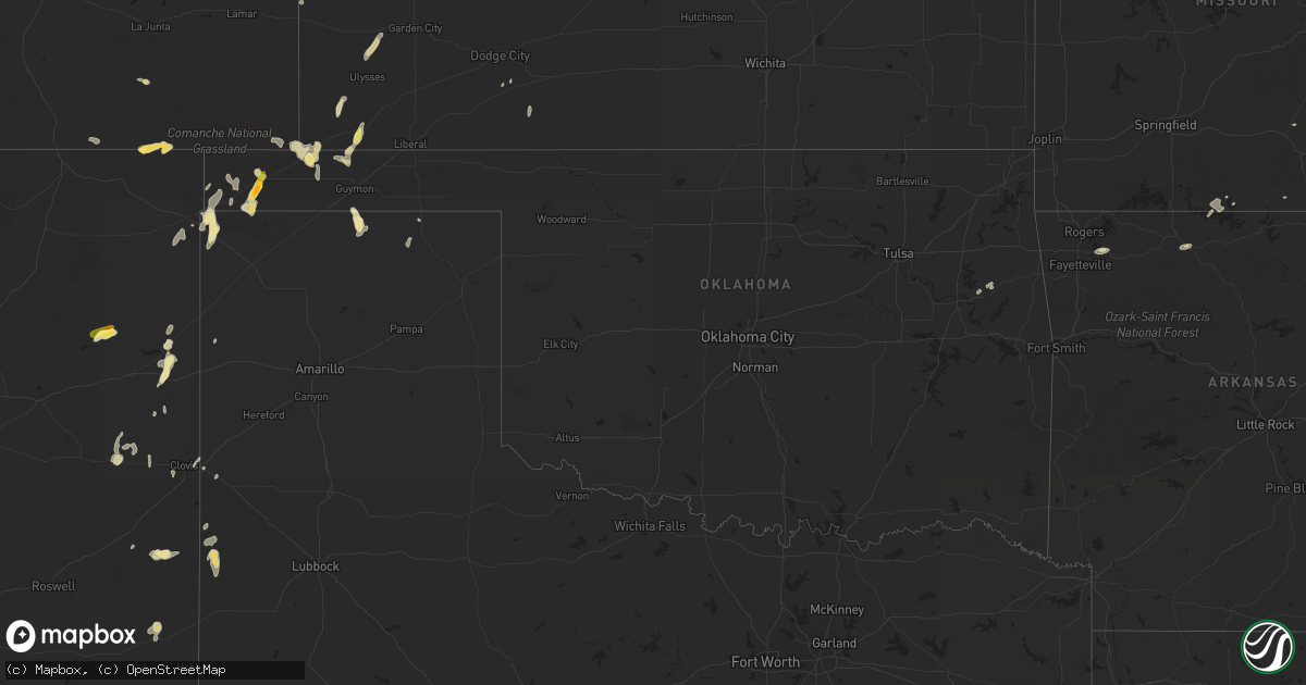
Hail Map in Oklahoma on July 9, 2015
Get this storm
July 9 map
$229
one time, instant access
Download today. No call, no setup
Keep the $229
Bought the map and want the full workflow? Apply the entire $229 to a subscription within 7 days. None of it is wasted.
Every map, not just this one
This buys you this map. Subscription and you get every map we run, in the markets you choose from a few cities to whole states to nationwide. Plus real-time alerts the moment a storm fires.
Contact data
Name, contact info, occupancy, even credit band for addresses in the footprint. You go from where it hit to who to call.
Become the source they trust
Unlimited branding weather history reports on demand. You already have the documented answer ready for the property owner, and you are the one who showed up with it.
Property data and RoofTrace estimates
Pull up any address you have got, its value and the exact code rules for that jurisdiction, straight from One Click Code. Then RoofTrace estimates the squares, pitch, and roof value, priced the way you price.
Storm reports in Oklahoma
Oklahoma
| Date | Description |
|---|---|
| 07/09/20155:35 PM CDT | Tree fell onto a pickup on 0638 rd a half mile west of highway 59 southwest of watts. |
| 07/09/20155:10 PM CDT | 8-10 inch diameter trees down in punkin hollow area. |
| 07/09/20155:08 PM CDT | Nws storm survey confirmed tornado traveled ne into adair co. Details to follow tomorrow. |
| 07/09/20155:04 PM CDT | Thunderstorm wind gust of 50 to 60 mph estimated at the nsu campus in tahlequah. |
| 07/08/20158:20 PM CDT | Hail to the size of golf balls was still falling. |
All States Impacted by Hail Map on July 9, 2015
Cities Impacted by Hail Map on July 9, 2015
- Kersey, CO
- Monument Valley, UT
- Magna, UT
- Richfield, KS
- Klamath Falls, OR
- Pueblo, CO
- Inglis, FL
- Van Buren, MO
- Fremont, MO
- Boulder, CO
- Luverne, AL
- Kim, CO
- Walsh, CO
- Branson, CO
- Grenville, NM
- Folsom, NM
- Conifer, CO
- Sedalia, CO
- Gruver, TX
- Lovington, NM
- San Jon, NM
- Green River, UT
- Bonnieville, KY
- Logan, NM
- Morton, TX
- Harrison, AR
- Doyle, CA
- Union Springs, AL
- Fitzpatrick, AL
- Hanksville, UT
- Minneola, KS
- Wells, NV
- Pine, CO
- Floyd, NM
- Grand Chain, IL
- Olmsted, IL
- Boise City, OK
- Guymon, OK
- Roggen, CO
- Trinchera, CO
- Andersonville, GA
- Sudan, TX
- Maple, TX
- Mize, MS
- Odessa, FL
- Land O'Lakes, FL
- Texline, TX
- Akron, CO
- Farwell, TX
- Yellville, AR
- Peel, AR
- Cedar Valley, UT
- Zalma, MO
- Gipsy, MO
- Felt, OK
- Goodwell, OK
- Elkhart, KS
- Dalhart, TX
- Columbia, KY
- Russell Springs, KY
- Colorado Springs, CO
- Usaf Academy, CO
- Keyes, OK
- Fallon, NV
- Milnesand, NM
- Pep, NM
- Conchas Dam, NM
- Isabella, MO
- Hugoton, KS
- Hilliard, FL
- Portola, CA
- Troy, AL
- Elida, NM
- Peyton, CO
- Theodosia, MO
- Winter Garden, FL
- Lakin, KS
- Saint George, GA
- Rush, CO
- Boulder, UT
- Casper, WY
- Ulysses, KS
- Cabool, MO
- Elk Creek, MO
- Safety Harbor, FL
- Eufaula, AL
- San Carlos, AZ
- Tallahassee, FL
- Midway, AL
- Evanston, WY
- Protem, MO
- Muleshoe, TX
- Hulbert, OK
- Tahlequah, OK
- Sedan, NM
- Lovelock, NV
- Blanding, UT
- Monument, CO
- Hindsville, AR
- Springdale, AR
- Advance, MO
- Chaffee, MO
- Oran, MO
- Grady, NM
- Saint Petersburg, FL
- Grand View, ID
- Campo, CO
- Winona, MO
- Clovis, NM
- Pittsview, AL
- Tabiona, UT
- Greenville, MO
- Glenallen, MO
- Perryton, TX
- Hawthorne, NV
- Nara Visa, NM
- Nancy, KY
- Syracuse, KS
- Bowling Green, KY
- Johnson, KS
- Melrose, NM
- Thebes, IL
- Miller City, IL
- Spring Hill, FL
- Lowndes, MO
- Moab, UT
- Caulfield, MO
- Escalante, UT
- Greenville, AL
- Buffalo Creek, CO
- Coffeeville, AL
- Karval, CO
- Park City, KY
- Glasgow, KY
- Adrian, TX
- Clayton, NM
- Folkston, GA
- Scott City, MO
- Tucumcari, NM
- Mcalister, NM
- Mounds, IL
- Texico, NM
- Fort Gibson, OK
- New Port Richey, FL
- Apopka, FL
- Fayetteville, AR
- Villa Ridge, IL
- Fairview, UT
- House, NM
- Winston, NM


