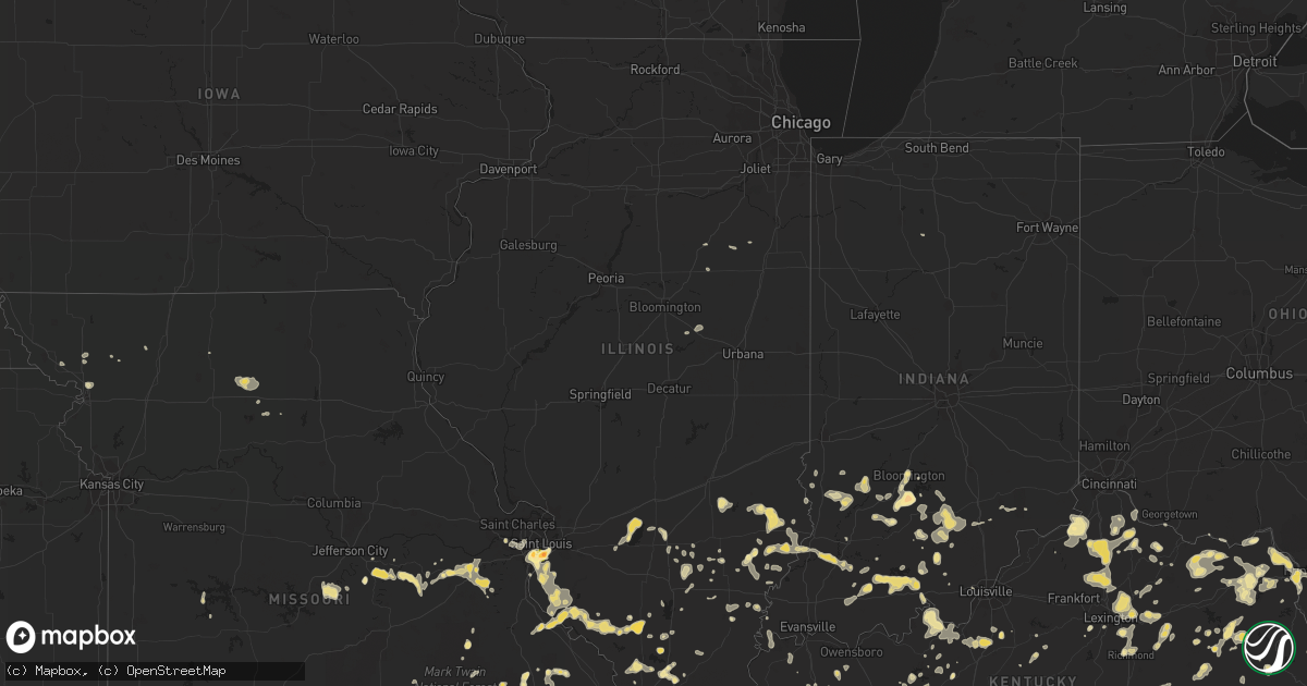
Hail Map in Illinois on July 8, 2012
Get this storm
July 8 map
$229
one time, instant access
Download today. No call, no setup
Keep the $229
Bought the map and want the full workflow? Apply the entire $229 to a subscription within 7 days. None of it is wasted.
Every map, not just this one
This buys you this map. Subscription and you get every map we run, in the markets you choose from a few cities to whole states to nationwide. Plus real-time alerts the moment a storm fires.
Contact data
Name, contact info, occupancy, even credit band for addresses in the footprint. You go from where it hit to who to call.
Become the source they trust
Unlimited branding weather history reports on demand. You already have the documented answer ready for the property owner, and you are the one who showed up with it.
Property data and RoofTrace estimates
Pull up any address you have got, its value and the exact code rules for that jurisdiction, straight from One Click Code. Then RoofTrace estimates the squares, pitch, and roof value, priced the way you price.
Storm reports in Illinois
Illinois
| Date | Description |
|---|---|
| 07/08/20126:59 PM CDT | A local report indicates 1.75 inch wind near DUPO |
| 07/08/20126:54 PM CDT | This was occurring at horseshoe lake |
| 07/08/20126:23 PM CDT | Trees down in waterloo on the 400 block of west mill road. Time estimated from radar. Report relayed by local media. |
| 07/08/20125:42 PM CDT | 8 inch diamter tree limbs down. |
| 07/08/20125:23 PM CDT | Small tree limbs down. |
| 07/08/20125:20 PM CDT | Also some small hail |
| 07/08/20124:30 PM CDT | A few large trees uprooted while large tree branches of 4 to 8 inches were snapped. Microbursts occurred in two corn fields flattened corn stalks. |
| 07/08/20123:55 PM CDT | 4 inch diameter tree limbs down. |
| 07/08/20123:15 PM CDT | A tree was blown down at the il 33/49 junction about 6 miles e/ne of newton. |
| 07/08/20123:10 PM CDT | Power lines were blown down onto east 600th avenue about 3 miles south of newton. |
| 07/08/20122:05 PM CDT | A tree was blown down 2 miles northwest of st. Francisville. |
| 07/08/20122:05 PM CDT | Tree limbs were blown down onto power lines on billett road south of lawrenceville. |
| 07/08/20122:00 PM CDT | Relayed by lawrence co ema |
| 07/07/20127:00 PM CDT | Golf ball size hail reported by amatteur radio operator in east carondelet |
All States Impacted by Hail Map on July 8, 2012
Cities Impacted by Hail Map on July 8, 2012
- Craigsville, VA
- Haworth, OK
- Owensville, MO
- Bland, MO
- Bowling Green, KY
- Costa, WV
- Ridgeview, WV
- Nellis, WV
- Batesville, AR
- Fountain Run, KY
- Gamaliel, KY
- Lafayette, TN
- Red Boiling Springs, TN
- Pineville, NC
- Charlotte, NC
- Honaker, VA
- Swords Creek, VA
- Linton, IN
- Sandborn, IN
- Richland, TX
- Wortham, TX
- Covesville, VA
- Faber, VA
- Marengo, IN
- Stratford, TX
- Cunningham, KY
- Bardwell, KY
- Waldron, AR
- Catlettsburg, KY
- Huntington, WV
- Kenova, WV
- Georgetown, KY
- Sadieville, KY
- Spencer, WV
- Waynesboro, VA
- Hestand, KY
- Moss, TN
- Blue River, OR
- Campo, CO
- English, IN
- Richmond, KY
- Lexington, KY
- Foster, KY
- Butler, KY
- Falmouth, KY
- Waterloo, IL
- Millstadt, IL
- Columbia, IL
- Goreville, IL
- Carbondale, IL
- Ozark, IL
- Marion, IL
- Saint Anthony, IN
- Celestine, IN
- Schnellville, IN
- Jasper, IN
- Birdseye, IN
- Minden, LA
- Princeton, LA
- Grantsburg, IN
- West Liberty, KY
- Umpire, AR
- Dierks, AR
- Glencoe, KY
- Sparta, KY
- Warsaw, KY
- Dry Ridge, KY
- Patriot, IN
- Red Bud, IL
- Scott Depot, WV
- Saint Albans, WV
- Winfield, WV
- Hurricane, WV
- Nitro, WV
- Otwell, IN
- Winslow, IN
- Pleasant Plains, AR
- South Portsmouth, KY
- Quincy, KY
- South Shore, KY
- Clarksville, TN
- Oblong, IL
- Claremont, IL
- Sumner, IL
- Sisters, OR
- Camp Sherman, OR
- Huntingburg, IN
- Taswell, IN
- Eckerty, IN
- Bristow, IN
- Pampa, TX
- Springville, IN
- Heltonville, IN
- Bedford, IN
- Bloomington, IN
- Spotsylvania, VA
- Fredericksburg, VA
- Woodford, VA
- Pierce City, MO
- Purdy, MO
- Monett, MO
- Orleans, IN
- Parks, AR
- Branson, CO
- Pembroke, KY
- Eudora, KS
- Whitleyville, TN
- Doniphan, MO
- Patoka, IL
- Alma, IL
- Salem, IL
- Holmes Mill, KY
- Closplint, KY
- Keokee, VA
- Flemington, WV
- Bridgeport, WV
- Lebanon, TN
- Watertown, TN
- Carlisle, IN
- Dugger, IN
- Sullivan, IN
- Mountain View, AR
- Melbourne, AR
- Maysville, KY
- Flemingsburg, KY
- Tollesboro, KY
- Wallingford, KY
- Vanceburg, KY
- Lebanon Junction, KY
- Vine Grove, KY
- West Point, KY
- Fort Knox, KY
- Elizabethtown, KY
- Radcliff, KY
- Wytheville, VA
- Nebo, KY
- Marysville, KS
- Inez, KY
- Pilgrim, KY
- Hopkinsville, KY
- Danville, AR
- Dardanelle, AR
- Greenville, KY
- Winchester, VA
- Providence, KY
- Clay, KY
- Princeton, KY
- Marion, KY
- Mountain Grove, MO
- Idanha, OR
- Detroit, OR
- Elkville, IL
- Dowell, IL
- Vergennes, IL
- Du Quoin, IL
- Springfield, TN
- Cross Plains, TN
- Orlinda, TN
- Calhoun, KY
- Evansville, IL
- Modoc, IL
- Prairie Du Rocher, IL
- Parma, MO
- Matthews, MO
- Catron, MO
- Pontiac, IL
- Fairbury, IL
- Dawson Springs, KY
- Fredonia, KY
- Pawnee City, NE
- Chapmanville, WV
- Koeltztown, MO
- Freeburg, MO
- Argyle, MO
- Pangburn, AR
- Judsonia, AR
- Post, OR
- Russellville, KY
- Olmstead, KY
- Dublin, VA
- Kim, CO
- East Saint Louis, IL
- Dupo, IL
- East Carondelet, IL
- Saint Louis, MO
- Williamsburg, KY
- Pine Knot, KY
- Augusta, KY
- Coeburn, VA
- Berryville, VA
- Charleston, MO
- McKenzie, TN
- Fairfield Bay, AR
- Bloomsdale, MO
- Sainte Genevieve, MO
- New Johnsonville, TN
- Jonesville, KY
- Stamping Ground, KY
- Williamstown, KY
- Berry, KY
- Owenton, KY
- Frankfort, KY
- Corinth, KY
- Madisonville, KY
- Gore, VA
- Lodi, MO
- Fredericktown, MO
- Silva, MO
- Greenville, MO
- Pierson, FL
- Henderson, NC
- Dieterich, IL
- Mount Sterling, KY
- Winchester, KY
- Campbellsburg, IN
- Hardinsburg, IN
- Bedford, VA
- Alton, MO
- Holladay, TN
- Rileyville, VA
- Sperryville, VA
- Fort Mill, SC
- Cadiz, KY
- Eddyville, KY
- Mechanicsville, MD
- Hughesville, MD
- Charlotte Hall, MD
- La Plata, MD
- Bryantown, MD
- Hulbert, OK
- Tahlequah, OK
- Marquand, MO
- Glasgow, KY
- Steeleville, IL
- Percy, IL
- Campbell Hill, IL
- Hodges, AL
- Tiline, KY
- Burna, KY
- Smithland, KY
- Brookport, IL
- Golconda, IL
- Salem, KY
- Leavenworth, IN
- Battletown, KY
- Potosi, MO
- Boise City, OK
- Spokane, MO
- Ponce De Leon, MO
- Highlandville, MO
- Galena, MO
- Bethpage, TN
- Westmoreland, TN
- Hartsville, TN
- Beattyville, KY
- Campton, KY
- Dexter, MO
- Havana, AR
- Belleview, MO
- Black, MO
- Cottage Grove, TN
- Murfreesboro, TN
- Linn, MO
- Belle, MO
- Bernie, MO
- Quitman, MS
- Crossville, IL
- Carmi, IL
- Falls Of Rough, KY
- Hanover, VA
- North Vernon, IN
- Lyons, IN
- Capron, VA
- Verona, MO
- Front Royal, VA
- Fort Valley, VA
- Strasburg, VA
- Kenton, OK
- Paron, AR
- Holland, IN
- Ferdinand, IN
- Otway, OH
- Blue Creek, OH
- Stout, OH
- West Portsmouth, OH
- Mitchell, IN
- Tamms, IL
- Jackson, KY
- Inverness, FL
- Shepherdsville, KY
- Clermont, KY
- Cedar Grove, TN
- Lignum, VA
- Elkwood, VA
- Remington, VA
- Goldvein, VA
- Richardsville, VA
- Bealeton, VA
- Stevensburg, VA
- Sumerduck, VA
- Brandenburg, KY
- Enfield, IL
- Springerton, IL
- Grandin, MO
- Makanda, IL
- Walsh, IL
- Versailles, KY
- Petersburg, IN
- West Salem, IL
- Bridgeport, IL
- Saint Francisville, IL
- Parkersburg, IL
- Calhoun, IL
- Monroe City, IN
- Mount Carmel, IL
- Lawrenceville, IL
- Allendale, IL
- Vincennes, IN
- Decker, IN
- Savannah, MO
- Saint Joseph, MO
- Grayson, KY
- Hitchins, KY
- Patterson, MO
- Clubb, MO
- Mount Olivet, KY
- Brooksville, KY
- Prineville, OR
- Pocahontas, AR
- Henderson, TX
- Union, MO
- Villa Ridge, MO
- Scott City, MO
- Benton, MO
- Ashland, VA
- Leslie, MO
- Cooperstown, ND
- Hannaford, ND
- Milan, TN
- Danville, WV
- Ellis Grove, IL
- Athens, TX
- Sedalia, KY
- Farmington, KY
- Fifty Six, AR
- Fults, IL
- Celina, TN
- Albany, TX
- Thebes, IL
- Tompkinsville, KY
- Jeffrey, WV
- Bob White, WV
- Clothier, WV
- Bim, WV
- Corydon, KY
- Delbarton, WV
- Matewan, WV
- Omar, WV
- Belfry, KY
- Williamson, WV
- McCarr, KY
- Somerset, KY
- Salem, IN
- Vallonia, IN
- Medora, IN
- Eastview, KY
- Caddo Gap, AR
- Glenwood, AR
- Mayfield, KY
- Wingo, KY
- Gruver, TX
- Burkesville, KY
- Stearns, KY
- Monticello, KY
- Earlington, KY
- Goodview, VA
- Steele, MO
- Elkview, WV
- Charleston, WV
- Donaldsonville, LA
- Scottsville, KY
- Slaughters, KY
- Sharon, TN
- Belgrade, MO
- Harrisburg, IL
- Galatia, IL
- West Point, VA
- Story, AR
- Mount Ida, AR
- Olive Hill, KY
- Granada, CO
- Stafford, VA
- Quantico, VA
- Shinnston, WV
- Brentwood, TN
- Nashville, TN
- Franklin, KY
- South Charleston, WV
- Dunbar, WV
- Amissville, VA
- Markham, VA
- Delaplane, VA
- Flint Hill, VA
- Hume, VA
- Huntly, VA
- Marshall, VA
- Woodbridge, VA
- Ironton, MO
- Arcadia, MO
- Annapolis, MO
- Paw Paw, WV
- Slanesville, WV
- Capon Bridge, WV
- Augusta, WV
- Morgantown, KY
- Reedy, WV
- Denniston, KY
- Frenchburg, KY
- Wellington, KY
- West Frankfort, IL
- Dundas, VA
- Fancy Farm, KY
- Hickory, KY
- Mount Erie, IL
- Broseley, MO
- Fisk, MO
- McKee, KY
- Sandgap, KY
- Winnfield, LA
- Perham, MN
- Prairie City, OR
- Freeman, VA
- Lawrenceville, VA
- Dolphin, VA
- Pinckneyville, IL
- Chester, IL
- Bonne Terre, MO
- Cutler, IL
- Ava, IL
- Sparta, IL
- Carthage, TN
- Lascassas, TN
- Bainbridge Island, WA
- Smyrna, TN
- Raleigh, MS
- Austin, IN
- Hazel Green, KY
- Bidwell, OH
- Patriot, OH
- Thurman, OH
- Gallipolis, OH
- Jonesville, VA
- Pennington Gap, VA
- Cranks, KY
- Kenvir, KY
- Coxs Creek, KY
- Orient, IL
- Carlyle, IL
- Saint Leonard, MD
- Broomes Island, MD
- Purdin, MO
- Meadville, MO
- Laclede, MO
- Linneus, MO
- Wheeling, MO
- Energy, IL
- Carterville, IL
- Herrin, IL
- Holly, CO
- Owensboro, KY
- Utica, KY
- Colonial Beach, VA
- Montross, VA
- Burns, OR
- Rush, KY
- Denton, KY
- Midland, VA
- Adairville, KY
- Deepwater, MO
- Lowry City, MO
- Gatewood, MO
- Poplar Bluff, MO
- Wolf Lake, IL
- Jonesboro, IL
- Norwood, MO
- Adolphus, KY
- Floral, AR
- Philippi, WV
- Spring Hill, TN
- Eminence, MO
- Louisville, IL
- Windermere, FL
- Orlando, FL
- Texarkana, TX
- Madison, IN
- Bushnell, FL
- Williamsburg, VA
- Brownstown, IN
- Ashwood, OR
- Des Arc, MO
- Shoals, IN
- Tupelo, MS
- Saltillo, MS
- Middleton, TN
- Barboursville, WV
- Salt Rock, WV
- Milton, WV
- Laurel, DE
- Bethel, DE
- Vinton, OH
- Caneyville, KY
- Dunnellon, FL
- Pomona, IL
- Alto Pass, IL
- Kuttawa, KY
- Malakoff, TX
- Loose Creek, MO
- Bonnots Mill, MO
- Paris, KY
- Ashford, WV
- Astor, FL
- Altoona, FL
- Warrenton, VA
- The Plains, VA
- Broad Run, VA
- Swoope, VA
- Staunton, VA
- Benton, KY
- Hardin, KY
- Greenville, IL
- Vandalia, IL
- Smithboro, IL
- Keyesport, IL
- Aylett, VA
- King William, VA
- Linden, VA
- Golden Gate, IL
- Fairfield, IL
- Arlington, KY
- Bend, OR
- Pocahontas, TN
- Hardy, AR
- Luebbering, MO
- Labadie, MO
- Robertsville, MO
- Rosebud, MO
- Lonedell, MO
- Saint Clair, MO
- Beaufort, MO
- Grubville, MO
- Gerald, MO
- Hilham, TN
- Uniontown, KS
- Redfield, KS
- Powhatan, VA
- Jeffersonville, KY
- Clay City, KY
- Livingston, TN
- Bluford, IL
- Mount Vernon, IL
- Springfield, KY
- Cookville, TX
- Warm Springs, AR
- Ravenden Springs, AR
- Williams, IN
- Crothersville, IN
- Yakima, WA
- McCool, MS
- Monroe, TN
- Burlingame, KS
- Paisley, FL
- Gracey, KY
- Essex, MO
- Providence Forge, VA
- Apopka, FL
- Amherstdale, WV
- Yolyn, WV
- Graham, WA
- Spanaway, WA
- Ellsinore, MO
- Murray, KY
- Kirksey, KY
- Mount Vernon, AR
- Leitchfield, KY
- Millwood, KY
- Greenfield, TN
- Bradleyville, MO
- Watson, OK
- Hooks, TX
- McDermott, OH
- Tuscumbia, AL
- Elkfork, KY
- Ezel, KY
- Longview, TX
- Goodwell, OK
- McKenney, VA
- Wilsons, VA
- Cunningham, TN
- Lexington, VA
- Wheaton, MO
- Fairview, MO
- Exeter, MO
- Payneville, KY
- Castlewood, VA
- Lebanon, VA
- Williford, AR
- Cherokee Village, AR
- Poca, WV
- Kenna, WV
- Atwood, TN
- Drasco, AR
- Palmetto, FL
- Parrish, FL
- Disputanta, VA
- Petersburg, VA
- Chester Gap, VA
- Smiths Grove, KY
- Park City, KY
- Romance, AR
- Belleville, AR
- Paris, AR
- Poulsbo, WA
- New York Mills, MN
- Rocky Comfort, MO
- Tuscumbia, MO
- Saint Elizabeth, MO
- Eldon, MO
- Eugene, MO
- Fredericksburg, IN
- Galax, VA
- Woodlawn, VA
- Guston, KY
- Verona, KY
- Clay Center, KS
- Green, KS
- Palmer, KS
- Bon Aqua, TN
- Fairview, TN
- Primm Springs, TN
- Osage City, KS
- Fort Belvoir, VA
- Washington, VA
- Crane, MO
- Nicholasville, KY
- Lake Creek, TX
- Wagarville, AL
- French Creek, WV
- Olney, IL
- King City, MO
- Arrowsmith, IL
- Le Roy, IL
- Eagle Rock, VA
- Max Meadows, VA
- Little Plymouth, VA
- Mattaponi, VA
- Shacklefords, VA
- Qulin, MO
- Dudley, MO
- Auburn, KY
- Mill Spring, MO
- Gandeeville, WV
- Walton, WV
- Home, KS
- Cisne, IL
- Moneta, VA
- Nora, VA
- Saint Paul, VA
- Warsaw, VA
- Stephenson, VA
- Star Tannery, VA
- Wardensville, WV
- High View, WV
- Mayslick, KY
- Ewing, KY
- Cobden, IL
- Loretto, KY
- Slade, KY
- Royalton, KY
- Salyersville, KY
- David, KY
- Prestonsburg, KY
- Blue River, KY
- Perryville, MO
- Vina, AL
- Tazewell, TN
- Loretto, VA
- Champlain, VA
- Caret, VA
- Hustle, VA
- Floral City, FL
- Iuka, IL
- Tamaroa, IL
- Rumsey, KY
- Clinton, AR
- Shirley, AR
- Port Royal, VA
- Bowling Green, VA
- Imperial, MO
- Arnold, MO
- Jackson, NC
- Langsville, OH
- Oak Grove, KY
- Patuxent River, MD
- Lusby, MD
- Puryear, TN
- Sedgewickville, MO
- Hedgesville, WV
- Berkeley Springs, WV
- Plainview, AR
- Mountain View, MO
- Jeffersonton, VA
- Grottoes, VA
- Sidney, AR
- Hanson, KY
- Dale, IN
- Tennyson, IN
- Gentryville, IN
- Boonville, IN
- Dowell, MD
- Norman, IN
- Scottsburg, IN
- Freetown, IN
- Piedmont, MO
- Princess Anne, MD
- Eden, MD
- Quantico, MD
- West Liberty, IL
- Prince Frederick, MD
- Lexington, TN
- Lavinia, TN
- Huntingdon, TN
- Middlebrook, VA
- Newton, MS
- Barhamsville, VA
- Toano, VA
- Lanexa, VA
- Walsh, CO
- Mulkeytown, IL
- Mitchell, OR
- Las Animas, CO
- Paris, TN
- Johnsonville, IL
- Norris City, IL
- Texarkana, AR
- Centerville, TN
- Nunnelly, TN
- Dickson, TN
- Greenup, KY
- Flatwoods, KY
- Ashland, KY
- Argillite, KY
- Mount Vernon, IN
- Milton, TN
- Coxs Mills, WV
- Glenville, WV
- Ekron, KY
- Dixon, KY
- Browns, IL
- Woodland, NC
- Rich Square, NC
- Solomons, MD
- Port Republic, MD
- Fairfield, VA
- Montgomery, WV
- Bruington, VA
- Walkerton, VA
- King And Queen Court House, VA
- Pottsville, AR
- Crawford, TX
- McGregor, TX
- Hagarville, AR
- Salem, MO
- Mount Pleasant, AR
- Evening Shade, AR
- Ceredo, WV
- South Point, OH
- Prichard, WV
- Russell, KY
- Irvington, KY
- Flat Rock, IL
- Ewing, VA
- Locust Grove, AR
- Marcella, AR
- Olive Branch, IL
- Onia, AR
- Pritchett, CO
- Springfield, CO
- Ballwin, MO
- Chesterfield, MO
- Jet, OK
- Bluemont, VA
- White Post, VA
- Boyce, VA
- Paris, VA
- Heber Springs, AR
- Wilburn, AR
- Laneview, VA
- Urbanna, VA
- Jamaica, VA
- Center Cross, VA
- Church View, VA
- Water View, VA
- Irvine, KY
- Big Clifty, KY
- Alpha, KY
- Albany, KY
- Cawood, KY
- Rose Bud, AR
- Metropolis, IL
- Columbia, KY
- Mauckport, IN
- Webster, KY
- Dittmer, MO
- Eagletown, OK
- Grannis, AR
- Wickes, AR
- Gillham, AR
- Sandy Hook, KY
- Wingate, MD
- Toddville, MD
- New Boston, TX
- Maud, TX
- Simms, TX
- Buckhannon, WV
- Mouth Of Wilson, VA
- Lansing, NC
- Grassy Creek, NC
- Yuma, TN
- Wildersville, TN
- De Kalb, TX
- Bixby, MO
- Moscow, OH
- California, KY
- Breese, IL
- Tad, WV
- Ona, WV
- Advent, WV
- Glenwood, WV
- Gay, WV
- Ripley, WV
- Belle, WV
- Culloden, WV
- Dover, AR
- Eustace, TX
- Mabank, TX
- White Cloud, KS
- Central City, KY
- Bremen, KY
- Bland, VA
- Crozet, VA
- Cooter, MO
- Blytheville, AR
- Honey Grove, TX
- Petty, TX
- Roxton, TX
- Branchland, WV
- Hamlin, WV
- Newton, IL
- Sainte Marie, IL
- Willow Hill, IL
- Garrison, KY
- Lawrence, KS
- Tonganoxie, KS
- Linwood, KS
- Bivalve, MD
- Nanticoke, MD
- Tacoma, WA
- Mechanicsville, VA
- Creal Springs, IL
- Deputy, IN
- Clintwood, VA
- Charlottesville, VA
- Lexington Park, MD
- La Harpe, KS
- Moran, KS
- Rappahannock Academy, VA
- Melber, KY
- La Center, KY
- Wickliffe, KY
- Kevil, KY
- McDaniels, KY
- Paoli, IN
- Carlisle, KY
- Shuqualak, MS
- Creston, WV
- Manquin, VA
- Leighton, AL
- Fort Scott, KS
- Russellville, AL
- Hiawatha, KS
- Trezevant, TN
- Jackson, TN
- Cameron, OK
- London, WV
- Mount Carbon, WV
- Hansford, WV
- Smithers, WV
- Cedar Grove, WV
- Hugheston, WV
- Powellton, WV
- Kimberly, WV
- Humboldt, NE
- Brookfield, MO
- Choctaw, AR
- Bee Branch, AR
- Washington, IN
- Oregon, MO
- New Kent, VA
- Saint Catharine, KY
- Oakland, MD
- Texico, IL
- Loogootee, IN
- Dubois, IN
- Brooksville, FL
- Jasonville, IN
- Waverly, TN
- Odin, IL
- Palestine, IL
- Palisades, WA
- Waterville, WA
- Volga, WV
- Sikeston, MO
- Canalou, MO
- Pineville, KY
- Franklin, TN
- Mclean, TX
- Tyaskin, MD
- Belington, WV
- Mount Clare, WV
- Lost Creek, WV
- French Lick, IN
- McFall, MO
- Whitakers, NC
- Mammoth Spring, AR
- La Grande, OR
- Manchester, OH
- Bonnerdale, AR
- Norman, AR
- Kirby, AR
- Murfreesboro, AR
- Langley, AR
- Quitman, AR
- Greenbrier, AR
- Guy, AR
- Cecilia, KY
- Cosby, MO
- Albany, OH
- Wilkesville, OH
- Lucasville, OH
- Cannel City, KY
- Rising Sun, IN
- Sanders, KY
- Florence, IN
- New Liberty, KY
- Russellville, AR
- Atkins, AR
- Mortons Gap, KY
- Nortonville, KY
- Rinard, IL
- Gloucester, VA
- Stanton, KY
- Miller City, IL
- Vinton, VA
- Kosse, TX
- White Swan, WA
- Camden, TN
- Marceline, MO
- Ozark, AR
- Middletown, VA
- Cairo, IL
- De Mossville, KY
- Shelburn, IN
- Centertown, KY
- Rockport, KY
- Farmer City, IL
- Germantown, KY
- Saint Charles, KY
- Royal, AR
- Eldorado, OK
- Royalton, IL
- Willisburg, KY
- Aurora, MO
- Forest Hills, KY
- Canada, KY
- Mize, KY
- De Queen, AR
- Reston, VA
- West Union, OH
- Neelyville, MO
- Murphysboro, IL
- Rio Grande, OH
- Table Rock, NE
- Greenleaf, KS
- Gassaway, WV
- Wayne City, IL
- Sims, IL
- Manitou, KY
- Damascus, AR
- Cynthiana, KY
- Mount Vernon, TX
- Talco, TX
- Mount Pleasant, TX
- Almo, KY
- Baldwin City, KS
- Campbellsburg, KY
- Crane, IN
- Odon, IN
- Corsicana, TX
- Shenandoah Junction, WV
- Harpers Ferry, WV
- Pettigrew, AR
- Palestine, TX
- Trinidad, TX
- Larue, TX
- Hudson, KY
- Bloomfield, KY
- Hillsboro, KY
- Church Creek, MD
- Kell, IL
- Rockbridge Baths, VA
- Elk Creek, MO
- Houston, MO
- Yukon, MO
- Willow Springs, MO
- Bradford, TN
- Velpen, IN
- Stendal, IN
- Kincaid, WV
- Scarbro, WV
- Fayetteville, WV
- Nashville, AR
- New Salisbury, IN
- East Prairie, MO
- Anniston, MO
- King George, VA
- Ocoee, FL
- Winter Garden, FL
- Caruthersville, MO
- Custer, KY
- Garfield, KY
- South Williamson, KY
- Mascot, VA
- Saluda, VA
- New Haven, MO
- Meta, MO
- Crowell, TX
- Cleveland, VA
- Bee, VA
- Dante, VA
- Miracle, KY
- Pathfork, KY
- Middlesboro, KY
- Clifton, IL
- Rothville, MO
- La Pine, OR
- Keenes, IL
- Arlington, VA
- Inwood, WV
- Kearneysville, WV
- Bunker Hill, WV
- Afton, VA
- Worthington, IN
- Coal City, IN
- Switz City, IN
- Bloomfield, IN
- Vashon, WA
- Naples, TX
- Marietta, TX
- Douglassville, TX
- Benedict, MD
- Henley, MO
- Ulman, MO
- Iberia, MO
- Valmeyer, IL
- Muscle Shoals, AL
- Lancaster, VA
- Quincy, WA
- Strunk, KY
- Readyville, TN
- Christiana, TN
- Bolckow, MO
- Campbell, MO
- Pollard, AR
- Gilbertown, AL
- Gunlock, KY
- Banner, MS
- Water Valley, MS
- Arnoldsburg, WV
- Upperville, VA
- Sidney, KY
- Hardy, KY
- Gilbert, WV
- Huddy, KY
- Foxhome, MN
- Campbell, MN
- Palmyra, IN
- Depauw, IN
- Grayville, IL
- La Vergne, TN
- Weston, CO
- Central, IN
- Rhodelia, KY
- Tumbling Shoals, AR
- Mena, AR
- Clinchco, VA
- Opdyke, IL
- Belle Rive, IL
- Allons, TN
- New Harmony, IN
- Patton, MO
- South Bay, FL
- Trenton, MO
- Beverly, WV
- Santa Fe, TN
- Ramer, TN
- Bradenton, FL
- Sarasota, FL
- Cross Junction, VA
- Scottown, OH
- Port Orchard, WA
- Cuba, MO
- Baker, WV
- Harned, KY
- Chaffee, MO
- Danese, WV
- Beaver, WV
- New Albany, IN
- Boles, AR
- Apollo Beach, FL
- Rosendale, MO
- Commiskey, IN
- Dupont, IN
- Lancaster, KS
- Pittsburg, KS
- Weir, KS
- Mcalester, OK
- Burke, VA
- Fairfax, VA
- Springfield, VA
- Annandale, VA
- Lost City, WV
- Woodlawn, TN
- Ashland City, TN
- Palmyra, TN
- Fort Campbell, KY
- Southside, TN
- Trenton, KY
- Cumberland Furnace, TN
- Owensburg, IN
- Dexter, KY
- Ochopee, FL
- Fremont, MO
- Alexandria, KY
- Morning View, KY
- Rosholt, SD
- Atlanta, TX
- Hueysville, KY
- Vest, KY
- Osceola, MO
- Ewing, IL
- Cullom, IL
- Buchanan, VA
- Bone Gap, IL
- Seymour, TX
- Toppenish, WA
- Quinton, VA
- Rio, WV
- Hazel, KY
- Birch Tree, MO
- Burnside, KY
- McLeansboro, IL
- Dahlgren, IL
- Waltonville, IL
- Tatum, TX
- Hallsville, TX
- Emerson, KY
- Morehead, KY
- Martinsburg, WV
- Breckenridge, MN
- Purcellville, VA
- Nortonville, KS
- Olaton, KY
- Como, MS
- Kewanna, IN
- Seagoville, TX
- Van, WV
- Seth, WV
- Twilight, WV
- Lake, WV
- Hewett, WV
- Foster, WV
- Madison, WV
- Willow Wood, OH
- Scooba, MS
- Fossil, OR
- Cambridge, MD
- Westport, TN
- Louisa, KY
- Amity, AR
- Town Creek, AL
- Wheeler, IL
- Whites Creek, TN
- Hamilton, VA
- Leesburg, VA
- Paeonian Springs, VA
- Saint Paul, AR
- Maize, KS
- Wichita, KS
- Portland, TN
- Albion, IL
- Ellery, IL
- Brandy Station, VA
- Rixeyville, VA


