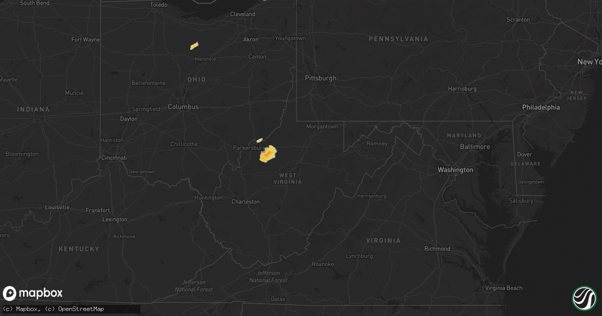
Hail Map in West Virginia on July 7, 2015
Get this storm
July 7 map
$229
one time, instant access
Download today. No call, no setup
Keep the $229
Bought the map and want the full workflow? Apply the entire $229 to a subscription within 7 days. None of it is wasted.
Every map, not just this one
This buys you this map. Subscription and you get every map we run, in the markets you choose from a few cities to whole states to nationwide. Plus real-time alerts the moment a storm fires.
Contact data
Name, contact info, occupancy, even credit band for addresses in the footprint. You go from where it hit to who to call.
Become the source they trust
Unlimited branding weather history reports on demand. You already have the documented answer ready for the property owner, and you are the one who showed up with it.
Property data and RoofTrace estimates
Pull up any address you have got, its value and the exact code rules for that jurisdiction, straight from One Click Code. Then RoofTrace estimates the squares, pitch, and roof value, priced the way you price.
Storm reports in West Virginia
West Virginia
| Date | Description |
|---|---|
| 07/07/20155:40 PM CDT | Trees down at route 88 and pine hill road |
| 07/07/20155:30 PM CDT | Trees down on 12th st |
| 07/07/20154:38 PM CDT | A few big trees down in the manila ridge area. Time estimated from radar. |
| 07/07/20154:30 PM CDT | Lots of small tree limbs across the road. |
| 07/07/20154:23 PM CDT | Trees down along wv 16 south between lizemores and the clay county line. Time estimated from radar. |
| 07/07/20154:20 PM CDT | Two large trees down... 12 in diameter. |
| 07/07/20154:10 PM CDT | Tree down at a residence in annamoriah |
| 07/07/20154:10 PM CDT | Tree down on power lines near intersection of rosalind and aracoma road... Time estimated from radar. |
| 07/07/20153:55 PM CDT | Spotter reported a tree down on rt 5 near creston... Time estimated from radar |
| 07/07/20153:15 PM CDT | One inch tree limbs down. |
| 07/07/20153:15 PM CDT | Tree down near intersection of heizer creek road and rt 62 partially blocking the road |
| 07/07/20153:10 PM CDT | Small tree limbs down due to wind gusts. |
| 07/07/20153:05 PM CDT | Tree down on rt 62 near poca high school... Partially blocking the road |
| 07/07/20152:54 PM CDT | Broken tree limbs were reported. |
All States Impacted by Hail Map on July 7, 2015
Cities Impacted by Hail Map on July 7, 2015
- Markleeville, CA
- Cloudcroft, NM
- Ashland, OR
- Carson City, NV
- Dayton, NV
- Mohall, ND
- Sherwood, ND
- Las Cruces, NM
- Hawthorne, NV
- Fort Hancock, TX
- New Washington, OH
- Shelby, OH
- Plymouth, OH
- Willard, OH
- Tiro, OH
- Zachary, LA
- Bartow, FL
- Moriarty, NM
- Alamogordo, NM
- Heber City, UT
- Harrisville, WV
- Cairo, WV
- Walker, WV
- Ellenboro, WV
- Macfarlan, WV
- Pennsboro, WV
- Smithville, WV
- Munday, WV
- Petroleum, WV
- Brohard, WV
- Elizabeth, WV
- Mulberry, FL
- Lithia, FL
- Liberty, MS
- Conneaut, OH
- Pittsburgh, PA
- La Pine, OR
- Dickinson, ND
- Manning, ND
- Marietta, OH
- Reno, OH
- Newport, OH
- Port Gibson, MS
- Cadiz, OH
- Fort Davis, TX
- Geneva, OH
- North Kingsville, OH
- Ashtabula, OH
- Lake Butler, FL
- Kentwood, LA
- Amite, LA
- Edgewood, NM
- Eden, AZ
- Pima, AZ
- Gonzales, LA
- Flomaton, AL
- Gloster, MS
- Rio Rancho, NM
- Bolton, MS
- Edwards, MS
- Vicksburg, MS
- Bentonia, MS
- Sierra Blanca, TX
- Klamath River, CA
- La Mesa, NM
- Medora, ND
- Reno, NV
- Perry, OH
- Snowville, UT
- Deming, NM
- Crown King, AZ
- Clint, TX
- Salt Flat, TX
- El Paso, TX
- Sewickley, PA
- Chester, CA
- Clewiston, FL
- Dell City, TX
- Tchula, MS
- Rock Springs, WY
- Magdalena, NM
- Painesville, OH
- Maxbass, ND
- Holloman Air Force Base, NM
- Eden, UT
- Pullman, WV
- Auburn, WV
- Berea, WV
- Wellington, NV
- New England, ND
- Brooker, FL
- Yreka, CA
- Dryden, TX
- Towaoc, CO
- Stanley, NM
- Sandia Park, NM
- Hatch, NM
- Aliquippa, PA
- Coraopolis, PA
- Clinton, PA
- Bend, OR
- Lookout, CA
- Rincon, NM
- Crosby, MS
- Marathon, TX
- Hammondsville, OH
- Loranger, LA
- Pride, LA
- Freedom, PA
- Rochester, PA
- Caballo, NM
- Morgan, UT
- Huntsville, UT
- Greensburg, LA
- Clinton, LA
- New Matamoras, OH
- Denham Springs, LA
- Lansford, ND
- Datil, NM
- Somes Bar, CA
- Happy Camp, CA
- Interlachen, FL
- Loyalton, CA
- Taylorsville, CA
- Fayette, MS
- Rodeo, NM
- Panama City, FL
- Youngstown, FL
- Conway, PA
- Baden, PA
- Cape Coral, FL
- Middleburg, FL
- Winston, NM
- Medford, OR
- Mayer, AZ
- Naples, FL
- Maben, MS
- Yazoo City, MS
- Woodville, MS
- Erin, TN
- Old Station, CA
- Cardwell, MT
- Williamsburg, NM
- White Sands Missile Range, NM
- Mesilla Park, NM
- Flagstaff, AZ
- Midway, UT
- Kamas, UT
- Tucumcari, NM
- San Jon, NM
- Logan, NM
- Bard, NM


