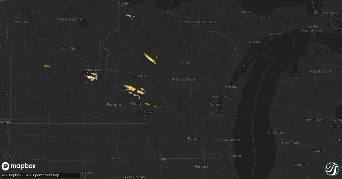
Hail Map in Wisconsin on July 7, 2014
Get this storm
July 7 map
$229
one time, instant access
Download today. No call, no setup
Keep the $229
Bought the map and want the full workflow? Apply the entire $229 to a subscription within 7 days. None of it is wasted.
Every map, not just this one
This buys you this map. Subscription and you get every map we run, in the markets you choose from a few cities to whole states to nationwide. Plus real-time alerts the moment a storm fires.
Contact data
Name, contact info, occupancy, even credit band for addresses in the footprint. You go from where it hit to who to call.
Become the source they trust
Unlimited branding weather history reports on demand. You already have the documented answer ready for the property owner, and you are the one who showed up with it.
Property data and RoofTrace estimates
Pull up any address you have got, its value and the exact code rules for that jurisdiction, straight from One Click Code. Then RoofTrace estimates the squares, pitch, and roof value, priced the way you price.
Storm reports in Wisconsin
Wisconsin
| Date | Description |
|---|---|
| 07/07/20146:45 PM CDT | A local report indicates 1.00 inch wind near 8 SW DURAND |
| 07/07/20146:27 PM CDT | Juneau county 911 call reported a couple of trees down in germantown township |
| 07/07/20146:00 PM CDT | Trained spotter reported hail sizes ranges from a nickel to a quarter |
| 07/07/20144:50 PM CDT | Tree blown down. |
| 07/07/20144:33 PM CDT | Trees down in the hatfield area north of black river falls. |
| 07/07/20144:03 PM CDT | Trees and power lines down all over osseo. |
| 07/07/20143:55 PM CDT | Tree down kieth street and bracket ave |
| 07/07/20143:45 PM CDT | A local report indicates 1.00 inch wind near 7 S ALTOONA |
| 07/07/20143:45 PM CDT | Tree damage reported from foster south to county line. |
| 07/07/20142:20 PM CDT | Late report. Damage to cars in the area. Many dents on my car roof and another cars in the area. |
| 07/07/20142:15 PM CDT | A local report indicates 1.50 inch wind near 9 NNE CORNELL |
| 07/07/20142:01 PM CDT | A local report indicates 1.00 inch wind near 5 S DONALD |
| 07/07/20141:55 PM CDT | A local report indicates 1.75 inch wind near 10 NE CORNELL |
| 07/07/20141:55 PM CDT | A local report indicates 1.50 inch wind near 9 NNE CORNELL |
| 07/06/201410:11 PM CDT | 3ft long tree branches blown down. Time estimated using rarar. |
| 07/06/20148:21 PM CDT | A local report indicates 1.00 inch wind near 1 NW HILLSBORO |
| 07/06/20148:20 PM CDT | A local report indicates 1.00 inch wind near 3 WNW HILLSBORO |
| 07/06/20148:07 PM CDT | A local report indicates 1.00 inch wind near 2 SSW KENDALL |
| 07/06/20148:04 PM CDT | Tree down on county d. |
| 07/06/20148:00 PM CDT | A local report indicates 1.00 inch wind near INDEPENDENCE |
| 07/06/20147:48 PM CDT | Time estimated from radar. |
| 07/06/20147:32 PM CDT | Both in leon and at the persons home 1.5 miles southeast of leon. Broke some lights on the garage...but that was the only damage. |
| 07/06/20147:19 PM CDT | A local report indicates 1.25 inch wind near 5 N SOLON SPRINGS |
| 07/06/20147:12 PM CDT | Picture received showing hail and size. Time estimated from radar. |
| 07/06/20147:10 PM CDT | Marquette county law enforcement reports trees down all over the county. Estimated time of event 630 pm to 710 pm. |
| 07/06/20147:00 PM CDT | 18 inch diameter tree branch blown down. |
All States Impacted by Hail Map on July 7, 2014
Cities Impacted by Hail Map on July 7, 2014
- Marquette, NE
- Archer, NE
- Chapman, NE
- Central City, NE
- Burnsville, MN
- Prior Lake, MN
- Shakopee, MN
- Minneapolis, MN
- Savage, MN
- Holcombe, WI
- Thedford, NE
- Valentine, NE
- Inland, NE
- Glenvil, NE
- Hastings, NE
- Waterloo, IL
- Oconto, NE
- Arvada, CO
- Saint Louis, MO
- Mitchell, NE
- Bayard, NE
- Melbeta, NE
- Scottsbluff, NE
- Gering, NE
- Sutton, NE
- Aurora, NE
- Alma, WI
- Clay Center, KS
- Wakefield, KS
- Eden Prairie, MN
- Lakeville, MN
- Saint Paul, MN
- Hebron, NE
- Nelson, WI
- Mondovi, WI
- Clatonia, NE
- Wilber, NE
- De Witt, NE
- Cortland, NE
- Crete, NE
- Harleyville, SC
- Holly Hill, SC
- Ridgeville, SC
- Hampton, NE
- Independence, WI
- Whitehall, WI
- Pickrell, NE
- Callaway, NE
- Litchfield, NE
- Strang, NE
- Carleton, NE
- Shickley, NE
- Bruning, NE
- Spooner, WI
- Eureka, MO
- High Ridge, MO
- House Springs, MO
- Hillsboro, MO
- Fenton, MO
- Pacific, MO
- Arnold, MO
- Dittmer, MO
- Barnhart, MO
- Cedar Hill, MO
- Imperial, MO
- Catawissa, MO
- Harrisburg, NE
- Saint George, SC
- Clay Center, NE
- Trumbull, NE
- Arcadia, WI
- Bruce, WI
- Solon Springs, WI
- Lake Nebagamon, WI
- Boulder, CO
- Eldorado Springs, CO
- Martin, SD
- Eddyville, NE
- Hastings, MN
- Juniata, NE
- Blue Hill, NE
- Fairfield, NE
- Ayr, NE
- Belvidere, NE
- Gill, CO
- Spring Grove, MN
- Flagler, CO
- Mabel, MN
- Louisville, CO
- Lafayette, CO
- Golden, CO
- Wheat Ridge, CO
- Broomfield, CO
- Millstadt, IL
- Durand, WI
- Alexandria, NE
- Geneva, NE
- Ohiowa, NE
- Brewster, NE
- Conrath, WI
- Chatfield, MN
- Wykoff, MN
- Sheldon, WI
- Dupo, IL
- East Carondelet, IL
- Lyons, CO
- Grand Island, NE
- Saint Libory, NE
- Strum, WI
- Grafton, NE
- Saronville, NE
- Harvard, NE
- Oakley, KS
- Longmont, CO
- Longford, KS
- Morganville, KS
- Riley, KS
- Taylor, NE
- Agate, CO
- Deer Trail, CO
- Genoa, CO
- Denver, CO
- Minnetonka, MN
- Columbia, IL
- Stewartville, MN
- Elsmere, NE
- Johnstown, NE
- Natoma, KS
- Plainville, KS
- Wyoming, MN
- Robertsville, MO
- Gilman, WI
- Beatrice, NE
- Verdon, NE
- Roseland, NE
- Bangor, WI
- Clarksville, OH
- Scott City, KS
- Cody, NE
- Merriman, NE
- Malvern, IA
- McCool Junction, NE
- Clifton, KS
- Clyde, KS
- Milligan, NE
- South Range, WI
- Cross, SC
- Fountain, MN
- Niwot, CO
- Cochrane, WI
- Fountain City, WI
- Palmer, NE
- Albers, IL
- Limon, CO
- Friend, NE
- Bartelso, IL
- Blair, WI
- Dunning, NE
- Davenport, NE
- Holmen, WI
- Valley Park, MO
- Rulo, NE
- Craig, MO
- Forest City, MO
- Henderson, NE
- Rosemount, MN
- Oregonia, OH
- Wilmington, OH
- Arcadia, NE
- Jordan, MN
- Tobias, NE
- Daykin, NE
- Shelton, NE
- Ravenna, NE
- Diller, NE
- Inver Grove Heights, MN
- Sumner, NE
- Erie, CO
- Lawrence, NE
- Phillips, NE
- Oregon, MO
- Osseo, WI
- Byers, CO
- Glenwood, IA
- Burr, NE
- Roca, NE
- Bennet, NE
- Douglas, NE
- Palmyra, NE
- Lincoln, NE
- Shelby, NE
- Rising City, NE
- Willmar, MN
- Raymond, MN
- Lake Lillian, MN
- Kearney, NE
- Amherst, NE
- Miller, NE
- Riverdale, NE
- Hazard, NE
- East Saint Louis, IL
- Mascoutah, IL
- Belleville, IL
- Monroe, OH
- Trenton, OH
- Franklin, OH
- Middletown, OH
- Waynesville, OH
- Minatare, NE
- Harrison, NE
- Ladysmith, WI
- Sparta, WI
- Mindoro, WI
- Pepin, WI
- Arkansaw, WI
- Shirley, MA
- Fitchburg, MA
- Ayer, MA
- Devens, MA
- Lunenburg, MA
- Leominster, MA
- Utica, NE
- Waco, NE
- Hordville, NE
- Goehner, NE
- Beaver Crossing, NE
- Seward, NE
- Polk, NE
- York, NE
- Bradshaw, NE
- Benedict, NE
- Gilead, NE
- Fairbury, NE
- Odin, IL
- Texico, IL
- Kell, IL
- Centralia, IL
- Keenes, IL
- Bluford, IL
- Iuka, IL
- Salem, IL


