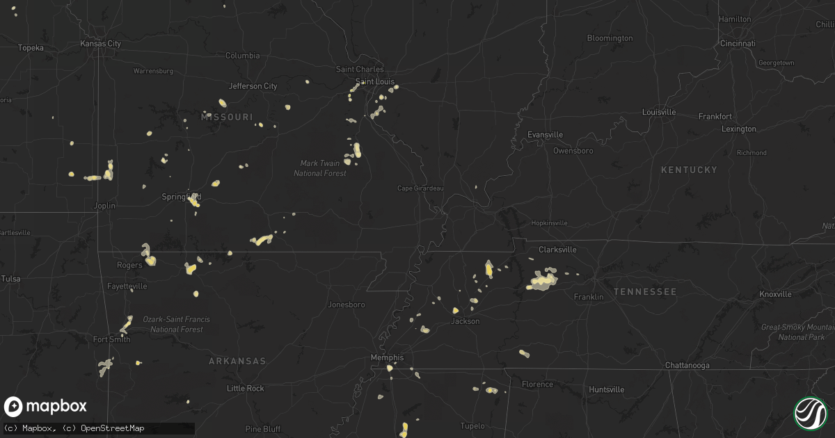
Hail Map in Arkansas on July 7, 2012
Get this storm
July 7 map
$229
one time, instant access
Download today. No call, no setup
Keep the $229
Bought the map and want the full workflow? Apply the entire $229 to a subscription within 7 days. None of it is wasted.
Every map, not just this one
This buys you this map. Subscription and you get every map we run, in the markets you choose from a few cities to whole states to nationwide. Plus real-time alerts the moment a storm fires.
Contact data
Name, contact info, occupancy, even credit band for addresses in the footprint. You go from where it hit to who to call.
Become the source they trust
Unlimited branding weather history reports on demand. You already have the documented answer ready for the property owner, and you are the one who showed up with it.
Property data and RoofTrace estimates
Pull up any address you have got, its value and the exact code rules for that jurisdiction, straight from One Click Code. Then RoofTrace estimates the squares, pitch, and roof value, priced the way you price.
Storm reports in Arkansas
Arkansas
| Date | Description |
|---|---|
| 07/07/20126:40 PM CDT | Reports of a few trees down in sulphur springs. |
| 07/07/20126:27 PM CDT | Trees and power lines are down in the mountain pine area. |
| 07/07/20123:50 PM CDT | Reports of tree damage via social media. Time estimated via radar. |
| 07/07/20123:30 PM CDT | Up to 4 inch diameter limbs downed at a campground. |
| 07/07/20123:05 PM CDT | Power lines and poles down on arkansas highway 22. |
| 07/07/20123:05 PM CDT | Large tree broken. Time estimated via radar. |
| 07/07/20122:35 PM CDT | Garage door damge to auto service station |
| 07/07/20122:35 PM CDT | 5 inch tree limb downed in southeast fayetteville at cherry hills boulevard and pumpkin ridge drive. Time estimated via radar. |
| 07/07/20122:10 PM CDT | Large tree down |
| 07/07/20121:10 PM CDT | Tree damage along with roof damage to barn |
| 07/06/20127:30 PM CDT | Some downed trees in the hardin community. |
All States Impacted by Hail Map on July 7, 2012
Cities Impacted by Hail Map on July 7, 2012
- Olean, NY
- Lacrosse, WA
- Inglis, FL
- Gallitzin, PA
- Ashville, PA
- Duncansville, PA
- Solomon, KS
- Otis, CO
- Marshfield, MO
- Niangua, MO
- Lead Hill, AR
- Dayton, WA
- Pomeroy, WA
- McFall, MO
- Pattonsburg, MO
- Ruston, LA
- Choudrant, LA
- Coal Valley, IL
- Lindsborg, KS
- Falun, KS
- Haigler, NE
- Brookston, TX
- Temperance, MI
- Erie, MI
- Maysville, MO
- King City, MO
- Albany, MO
- Union Star, MO
- Darlington, MO
- Amity, MO
- Republican City, NE
- Mountainburg, AR
- Seville, FL
- Mount Judea, AR
- Vendor, AR
- Chapman, KS
- Wakefield, KS
- Kosse, TX
- Shirleysburg, PA
- Mapleton Depot, PA
- Mount Union, PA
- Southaven, MS
- Memphis, TN
- Columbia, IL
- Millstadt, IL
- Quinlan, TX
- Greenville, TX
- Eureka, MO
- Ballwin, MO
- Wray, CO
- Middle Brook, MO
- Pilot Knob, MO
- Ironton, MO
- Belleview, MO
- Murray, KY
- Hildreth, NE
- Tennessee Ridge, TN
- Dover, TN
- Woodrow, CO
- Fort Morgan, CO
- Rogersville, MO
- Springfield, MO
- Berthoud, CO
- Longmont, CO
- Marysville, PA
- Shermans Dale, PA
- Courtland, MS
- Water Valley, MS
- Batesville, MS
- Strasburg, CO
- Mifflintown, PA
- McAlisterville, PA
- Turtlepoint, PA
- Port Allegany, PA
- Deer Trail, CO
- Quinter, KS
- Osceola, MO
- El Dorado Springs, MO
- Tillatoba, MS
- Charleston, MS
- Cascilla, MS
- Beverly, KS
- Collierville, TN
- Byhalia, MS
- Austin, PA
- Coudersport, PA
- Marienthal, KS
- Leoti, KS
- Wilton, IA
- Cope, CO
- Booneville, MS
- Trenton, TX
- Wauneta, NE
- Benkelman, NE
- Joes, CO
- Grand River, IA
- Philipsburg, PA
- Emlenton, PA
- Foxburg, PA
- Walnut, KS
- Girard, KS
- McCune, KS
- Doe Run, MO
- Farmington, MO
- Park Hills, MO
- Wallowa, OR
- Pittsburg, KS
- Tamaqua, PA
- Mountain View, MO
- Belleville, IL
- O'Fallon, IL
- Crockett, TX
- Smethport, PA
- Derrick City, PA
- Duke Center, PA
- Rixford, PA
- Bradford, PA
- Eldred, PA
- Colby, KS
- Williamsport, PA
- Montoursville, PA
- Cogan Station, PA
- Trout Run, PA
- Saint Francis, KS
- Lamar, MO
- Oronogo, MO
- Liberal, MO
- Mindenmines, MO
- Lavinia, TN
- Naponee, NE
- Minden, NE
- Collinwood, TN
- Waynesboro, TN
- Olivehill, TN
- Williston, FL
- Bronson, FL
- Byers, CO
- Monument, OR
- Eureka Springs, AR
- Henry, TN
- Paris, TN
- Limon, CO
- Frontenac, KS
- Millville, PA
- Turbotville, PA
- Bloomsburg, PA
- Danville, PA
- Harrison, AR
- Soldier, KS
- Cleveland, TX
- Karthaus, PA
- Frenchville, PA
- Benezett, PA
- Montgomery, PA
- Roaring Branch, PA
- Muncy, PA
- Liberty, PA
- Morris, PA
- Ralston, PA
- Rolla, MO
- Falcon, MO
- Laquey, MO
- Dickson, TN
- Seligman, MO
- Ward, AL
- Gove, KS
- East Palatka, FL
- Leaf River, IL
- Anton, CO
- Utica, KS
- Beeler, KS
- Hays, KS
- Schoenchen, KS
- McCracken, KS
- Venango, NE
- Fort Collins, CO
- Wellington, CO
- Tennessee Colony, TX
- Oakwood, TX
- Montalba, TX
- Palestine, TX
- Heavener, OK
- Howe, OK
- Poteau, OK
- Reynoldsville, PA
- Bird City, KS
- Kanorado, KS
- Goodland, KS
- New Ringgold, PA
- Deshler, NE
- Hebron, NE
- Calhan, CO
- Cimarron, KS
- Pottersville, MO
- Caulfield, MO
- Campbell, TX
- Cumby, TX
- Dixon, MO
- Vienna, MO
- Bells, TN
- Gadsden, TN
- Humboldt, TN
- Castle Rock, CO
- House Springs, MO
- Pfeifer, KS
- Otis, KS
- Gorham, KS
- Hoisington, KS
- Russell, KS
- Palisade, NE
- Monument, KS
- Coushatta, LA
- Shreveport, LA
- Mansfield, LA
- Lovelady, TX
- Emporium, PA
- Pilot Rock, OR
- Kirk, CO
- Valmeyer, IL
- Alma, AR
- Van Buren, AR
- Honey Grove, TX
- Ladonia, TX
- Fair Play, MO
- Fults, IL
- Renovo, PA
- West Plains, MO
- Moody, MO
- Scandia, KS
- Norway, KS
- Jamestown, KS
- Concordia, KS
- Royal, AR
- Mountain Pine, AR
- Milan, TN
- Long Creek, OR
- Corinth, MS
- Homosassa, FL
- Oakland, AR
- Mountain Home, AR
- McEwen, TN
- Waverly, TN
- Vanleer, TN
- Punxsutawney, PA
- Stump Creek, PA
- Westport, PA
- Cross Fork, PA
- Cottage Grove, TN
- Genoa, CO
- Tremont, PA
- Muir, PA
- Valley View, PA
- Pine Grove, PA
- Tower City, PA
- Hegins, PA
- South Greenfield, MO
- Savannah, MO
- Helena, MO
- Kaufman, TX
- Tipton, IA
- Ford City, PA
- Elderton, PA
- Shelocta, PA
- Rural Valley, PA
- Kittanning, PA
- Hopewell, NJ
- Waverly, NY
- Covington, TN
- Bland, MO
- Friendship, NY
- Whitesville, NY
- Genesee, PA
- Wellsville, NY
- Belmont, NY
- Black Creek, NY
- Scio, NY
- Oxford, MS
- Taylor, MS
- Weatherby, MO
- Bethany, MO
- New Hampton, MO
- Mineral Point, MO
- Bonne Terre, MO
- De Soto, MO
- Fletcher, MO
- Cedar Hill, MO
- Downsville, LA
- Hartford, AR
- Hackett, AR
- Cameron, OK
- Kersey, CO
- Colmesneil, TX
- Woodville, TX
- Hickory, KY
- Louisburg, MO
- Urbana, MO
- Whitewright, TX
- Bonham, TX
- Leonard, TX
- Baton Rouge, LA
- Saint Gabriel, LA
- Gleason, TN
- Minneapolis, KS
- Bennington, KS
- Shinglehouse, PA
- Ulysses, PA
- Alma, NY
- Scott City, KS
- Newport, PA
- Millerstown, PA
- Thompsontown, PA
- Lancaster, PA
- Strasburg, PA
- Kennard, TX
- Elkhart, TX
- Tishomingo, MS
- Ripley, TN
- Henning, TN
- Mansfield, PA
- Ida, MI
- Oakland, MS
- Phillipsburg, NJ
- Milford, NJ
- Bloomsbury, NJ
- Burlington, CO
- Idalia, CO
- Bethel, PA
- Berger, MO
- Pontiac, MO
- Jackson, TN
- Ickesburg, PA
- Bismarck, MO
- Gypsum, KS
- Salina, KS
- Barnesville, PA
- Crosby, PA
- Lock Haven, PA
- Leesville, LA
- McDonald, KS
- Stanton, TN
- Nescopeck, PA
- Sugarloaf, PA
- Rock Falls, IL
- Iuka, MS
- Delmar, IA
- Maquoketa, IA
- Grand Mound, IA
- Lost Nation, IA
- Max, NE
- Boaz, KY
- Winona, KS
- Woodville, MS
- Bedford, IN
- Schererville, IN
- Dyer, IN
- Lanark, IL
- Milledgeville, IL
- Charlotte, IA
- Mayport, PA
- Wrightsville, PA
- Sinnamahoning, PA
- Roxton, TX
- Ceres, NY
- Little Genesee, NY
- Allegany, NY
- Franklinville, NY
- Bolivar, NY
- Portville, NY
- Roulette, PA
- Cuba, NY
- Belfast, NY
- Brick, NJ
- Lavallette, NJ
- Toms River, NJ
- Lakewood, NJ
- Mantoloking, NJ
- Terrell, TX
- Honey Grove, PA
- East Waterford, PA
- Blossburg, PA
- Wellsboro, PA
- Byron, IL
- Oregon, IL
- Agate, CO
- Galeton, PA
- Sabinsville, PA
- Birch Tree, MO
- Syracuse, KS
- Champion, NE
- Imperial, NE
- Nordheim, TX
- Annawan, IL
- Mulberry, AR
- Sarah, MS
- Coldwater, MS
- Senatobia, MS
- Yellville, AR
- Glasco, KS
- Barnett, MO
- Eldon, MO
- Fredericktown, MO
- New Haven, MO
- Berwick, PA
- Welda, KS
- Washington, IN
- Hodgen, OK
- Imnaha, OR
- Ashland City, TN
- Pope, MS
- Penn Run, PA
- Festus, MO
- York, AL
- Cuba, AL
- Levant, KS
- Horn Lake, MS
- Eustis, FL
- Bellefonte, PA
- Clarence, PA
- Howard, PA
- Booneville, AR
- Yuma, CO
- Scott Air Force Base, IL
- Dighton, KS
- Mankato, KS
- Burr Oak, KS
- Saint Marys, PA
- Atalissa, IA
- Rienzi, MS
- Burnsville, MS
- Bloomington, NE
- Dunnegan, MO
- Morris Run, PA
- Covington, PA
- Marquez, TX
- Skillman, NJ
- Princeton, NJ
- Princeton Junction, NJ
- Cranbury, NJ
- Plainsboro, NJ
- Assaria, KS
- Springville, TN
- Golconda, IL
- Union Church, MS
- Wesson, MS
- Brookhaven, MS
- Broomfield, CO
- Strafford, MO
- Halls, TN
- Friendship, TN
- Waterloo, IL
- Huntingdon, TN
- Bernice, LA
- Lorraine, KS
- Jacksonville, FL
- Trenton, TN
- Trenton, MO
- Carlisle, PA
- Landisburg, PA
- Newville, PA
- Akron, CO
- Bronson, KS
- Gravois Mills, MO
- Mount Carroll, IL
- La Crosse, KS
- Petty, TX
- Astor, FL
- Pierson, FL
- Longford, KS
- Reading, PA
- Reinholds, PA
- Middlebury Center, PA
- Hamburg, PA
- Fleetwood, PA
- Kutztown, PA
- Franklin Grove, IL
- Ashton, IL
- Chana, IL
- Brinktown, MO
- Moreauville, LA
- Marksville, LA
- Wister, OK
- Cassville, MO
- Eagle Rock, MO
- Elm Grove, LA
- Alton, MO
- Lone Oak, TX
- Crescent City, FL
- Kerens, TX
- Irondale, MO
- Huntsville, MO
- Canaseraga, NY
- Swain, NY
- Cream Ridge, NJ
- Vernon, CO
- Loretto, PA
- Ebensburg, PA
- Cresson, PA
- Warsaw, MO
- Eckley, CO
- Millersville, PA
- Willow Street, PA
- Green Cove Springs, FL
- Palatka, FL
- Centerville, TX
- Red Banks, MS
- Bernville, PA
- Mohrsville, PA
- Sparta, MO
- Crown Point, IN
- Saint John, IN
- Vichy, MO
- Stevens, PA
- Ephrata, PA
- New Holland, PA
- Terre Hill, PA
- East Earl, PA
- Mohnton, PA
- Narvon, PA
- Eden, NY
- Monterey, LA
- Schuylkill Haven, PA
- Auburn, PA
- Reagan, TX
- Medina, TN
- Pomona Park, FL
- Brookville, PA
- Coolspring, PA
- Cumberland Furnace, TN
- Saint Louis, MO
- Omaha, AR
- Alpena, AR
- Parker, CO
- Franktown, CO
- Uniontown, KS
- Benton, PA
- White Bluff, TN
- Charlotte, TN
- Slagle, LA
- Manchester Township, NJ
- Jackson, NJ
- Millstone Township, NJ
- Lakehurst, NJ
- Lemoyne, PA
- Camp Hill, PA
- New Cumberland, PA
- Preston, IA
- Birdsboro, PA
- Heartwell, NE
- Ronks, PA
- Paradise, PA
- Washington Boro, PA
- Columbia, PA
- Honey Brook, PA
- Mountville, PA
- York, PA
- Gordonville, PA
- Coatesville, PA
- Parkesburg, PA
- Kinzers, PA
- Gap, PA
- Pittsburgh, PA
- Jackson, LA
- Saint Francisville, LA
- Ventress, LA
- Trout Creek, MT
- Wells, TX
- Alto, TX
- Athens, PA
- Sayre, PA
- Hightstown, NJ
- Monroe Township, NJ
- Lenhartsville, PA
- West Springfield, PA
- Albion, PA
- Holton, KS
- Allentown, NJ
- Robbinsville, NJ
- Linneus, MO
- Orwigsburg, PA
- Brighton, CO
- Kersey, PA
- Weedville, PA
- Stonewall, LA
- Frierson, LA
- Pacific, MO
- Dubach, LA
- Farmerville, LA
- Crane, MO
- Arriba, CO
- Atkinson, IL
- McKenzie, TN
- Walnut Grove, MO
- Clifton Hill, MO
- Trezevant, TN
- Oakley, KS
- Belleville, KS
- Bison, KS
- Huntingdon, PA
- Blain, PA
- McVeytown, PA
- Cassville, PA
- Calvin, PA
- Orbisonia, PA
- Loysville, PA
- Hernando, MS
- Nesbit, MS
- Edwards, MO
- Washburn, MO
- Garfield, AR
- Sterling, IL
- Cranesville, PA
- San Mateo, FL
- Satsuma, FL
- Hughesville, PA
- Brooksville, FL
- Fayetteville, AR
- Yorktown, TX
- Birdseye, IN
- Jersey Shore, PA
- Corrigan, TX
- Livingston, TX
- Indiana, PA
- Rochelle, IL
- Pottersdale, PA
- Natchez, MS
- Jewett, TX
- Grapeland, TX
- Aurora, IN
- Beachwood, NJ
- Bayville, NJ
- Lanoka Harbor, NJ
- Ocean Gate, NJ
- Pine Beach, NJ
- Whiteland, IN
- Erin, TN
- Spring Hill, FL
- Cross Timbers, MO
- Chiefland, FL
- Trenton, FL
- Grand Cane, LA
- Estero, FL
- Fort Myers, FL
- Paris, TX
- Blossom, TX
- North Bend, PA
- Chadwick, IL
- Norman, IN
- Bronaugh, MO
- Jasper, MO
- Albia, IA
- Moscow, TX
- Bolivar, MO
- Unityville, PA


