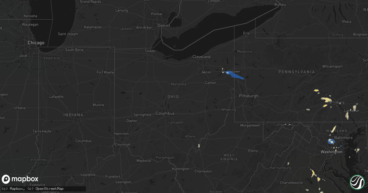
Hail Map in Ohio on July 5, 2026
Get this storm
July 5 map
$229
one time, instant access
Download today. No call, no setup
Keep the $229
Bought the map and want the full workflow? Apply the entire $229 to a subscription within 7 days. None of it is wasted.
Every map, not just this one
This buys you this map. Subscription and you get every map we run, in the markets you choose from a few cities to whole states to nationwide. Plus real-time alerts the moment a storm fires.
Contact data
Name, contact info, occupancy, even credit band for addresses in the footprint. You go from where it hit to who to call.
Become the source they trust
Unlimited branding weather history reports on demand. You already have the documented answer ready for the property owner, and you are the one who showed up with it.
Property data and RoofTrace estimates
Pull up any address you have got, its value and the exact code rules for that jurisdiction, straight from One Click Code. Then RoofTrace estimates the squares, pitch, and roof value, priced the way you price.
Storm reports in Ohio
Ohio
| Date | Description |
|---|---|
| 07/05/20265:10 PM CDT | Large tree down on power line. Photo verified. |
| 07/05/20261:46 PM CDT | Trees down on north cadillac drive in boardman. |
| 07/05/20261:43 PM CDT | Multiple large limbs and power lines downed. |
| 07/05/20261:41 PM CDT | Large trees down including some uprooted... Falling in different directions. |
| 07/05/20261:28 PM CDT | Significant tree damage throughout poland. A photo was shared by broadcast media of a large tree downed onto a house causing structural damage. |
| 07/05/20261:26 PM CDT | Significant tree damage on tanglewood drive in boardman. Many large limbs downed and trees uprooted. |
| 07/05/20261:25 PM CDT | Spotter estimated 50-60 mph winds and measured over 1 inch of rain in 30 minutes. |
| 07/05/20261:25 PM CDT | Large tree down on a house on highland drive. |
| 07/05/20261:25 PM CDT | Large tree down on a house on tara drive. |
| 07/05/20261:25 PM CDT | Tree uprooted on delaware drive. |
| 07/05/20261:25 PM CDT | Measured on handheld anemometer. |
| 07/05/20261:24 PM CDT | Glass entry door shattered at an apartment complex in cornersburg. Time estimated via radar. |
| 07/05/20261:22 PM CDT | Estimated 60-65 mph winds and dime size hail. |
| 07/05/20261:20 PM CDT | 5 inch diameter branches down. |
| 07/05/20261:20 PM CDT | Broadcast media shared a photo of multiple trees that fell and took down power poles on tippecanoe road. Time estimated from radar. |
| 07/05/20261:18 PM CDT | Large tree uprooted off of shields road near the corner of lockwood blvd. |
| 07/05/20261:17 PM CDT | Many large trees snapped or uprooted between canfield and boardman. |
| 07/05/20261:15 PM CDT | Extensive tree and power line damage at hopkins rd and shields rd. |
| 07/05/20261:15 PM CDT | 60+mph wind estimates and nickel side hail near state route 46 and kirk rd. |
| 07/05/20261:13 PM CDT | Trees and power lines downed near the intersection of kirk road and state route 46. |
| 07/05/20261:13 PM CDT | Social media photo of the sign for the boardman plaza partially blown over. Time estimated from radar. |
| 07/05/20261:10 PM CDT | Large trees snapped and power lines downed on the corner of mellinger road and raccoon road. Time estimated via radar. |
| 07/05/202612:55 PM CDT | 2 large trees downed and power out. |
| 07/04/20268:10 PM CDT | A tree was blown down and is being suspended by power lines about a mile from old us 33 southeast of athens. Time estimated by radar. |
| 07/04/20267:00 PM CDT | Tree down at the intersection of powder plant road and infirmary road. Time estimated by radar. |
All States Impacted by Hail Map on July 5, 2026
Cities Impacted by Hail Map on July 5, 2026
- Lynnville, TN
- Cornersville, TN
- Columbia, TN
- Lewisburg, TN
- Wartrace, TN
- Shelbyville, TN
- Bell Buckle, TN
- Manchester, TN
- Beechgrove, TN
- Pulaski, TN
- Westpoint, TN
- Iron City, TN
- Bradyville, TN
- Hampshire, TN
- Woodbury, TN
- Ethridge, TN
- Mcminnville, TN
- Oliver Springs, TN
- Oak Ridge, TN
- Ringling, OK
- Mount Pleasant, TN
- Lawrenceburg, TN
- Wrightsville, GA
- Reynolds, GA
- Leoma, TN
- Wilson, OK
- Liberty, TN
- McBee, SC
- Elkmont, AL
- Summertown, TN
- Spencer, TN
- Sparta, TN
- Athens, AL
- Ardmore, AL
- Toney, AL
- Warren, OH
- Newton Falls, OH
- Duck River, TN
- Fletcher, OK
- Patrick, SC
- Cheraw, SC
- Soddy Daisy, TN
- Kite, GA
- Mount Croghan, SC
- Diamond, OH
- Prospect, TN
- Hartsville, SC
- North Jackson, OH
- McDonald, TN
- Ooltewah, TN
- Rush Springs, OK
- Ryan, OK
- Marlow, OK
- Oldtown, MD
- Given, WV
- Canfield, OH
- Youngstown, OH
- Cumberland, MD
- Lowellville, OH
- Struthers, OH
- Altoona, AL
- Liberty, WV
- Kenna, WV
- Adams Run, SC
- Ripley, WV
- New Middletown, OH
- Bessemer, PA
- Petersburg, OH
- Edinburg, PA
- Hillsville, PA
- Enon Valley, PA
- New Castle, PA
- Franklinton, LA
- Duncan, OK
- Hamlet, NC
- Laurel Hill, NC
- Bennettsville, SC
- McClure, IL
- Cape Girardeau, MO
- Ravenel, SC
- Ridgeville, SC
- Ninnekah, OK
- Fort Lauderdale, FL
- West Pittsburg, PA
- Wampum, PA
- Loretto, TN
- Jonesboro, IL
- Charleston, MO
- Bogalusa, LA
- Foxworth, MS
- Aberdeen, NC
- Gibson, NC
- Laurinburg, NC
- Opelika, AL
- Angie, LA
- Gallant, AL
- Loranger, LA
- Independence, LA
- Roseland, LA
- Amite, LA
- Ashville, AL
- Rainbow City, AL
- Anniston, MO
- East Prairie, MO
- Southern Pines, NC
- Attalla, AL
- Tickfaw, LA
- Cusseta, AL
- Columbia, MS
- Lexington, TN
- Medina, TN
- Milan, TN
- Wichita Falls, TX
- Henrietta, TX
- Sheppard Afb, TX
- Electra, TX
- New Madrid, MO
- Wildersville, TN
- Hurricane Mills, TN
- Lobelville, TN
- Waverly, TN
- Fort Bragg, NC
- Comanche, OK
- Bush, LA
- Covington, LA
- Carthage, NC
- Vass, NC
- Menlo, GA
- Collins, MS
- Reedsville, OH
- Long Bottom, OH
- Portland, OH
- Ravenswood, WV
- Gadsden, AL
- Gleason, TN
- Summerville, GA
- McEwen, TN
- Folsom, LA
- Franklinton, NC
- Galivants Ferry, SC
- Portersville, PA
- Ellwood City, PA
- Harmony, PA
- Iowa Park, TX
- Manning, SC
- Livingston, LA
- Canton, TX
- Westport, TN
- Locust Fork, AL
- Cleveland, AL
- Spencer, WV
- Looneyville, WV
- Cameron, NC
- Hereford, TX
- Fernandina Beach, FL
- Yulee, FL
- Jacksonville, FL
- Ponchatoula, LA
- Brunswick, GA
- Savannah, GA
- Port Royal, VA
- McKenzie, TN
- Bellevue, TX
- Orma, WV
- Arnoldsburg, WV
- Clinton, LA
- Raeford, NC
- Alcolu, SC
- Linden, TN
- Temple, OK
- Aynor, SC
- McLeansboro, IL
- Broughton, IL
- Lindale, TX
- Tyler, TX
- Cunningham, TN
- Clarksville, TN
- Springville, AL
- Arp, TX
- Trion, GA
- Bardwell, KY
- Arlington, KY
- Paris, TN
- Henry, TN
- Mansfield, TN
- Ben Wheeler, TX
- Harrold, TX
- Nichols, SC
- Holden, LA
- Springfield, LA
- Holliday, TX
- Campbell, OH
- Marion, SC
- Canyon, TX
- Pearl River, LA
- Whitehouse, TX
- Walsenburg, CO
- Picayune, MS
- Byers, TX
- Waurika, OK
- Orlando, FL
- Windermere, FL
- Hastings, OK
- Mullins, SC
- Cope, SC
- Cumberland Furnace, TN
- Buchanan, TN
- Abita Springs, LA
- Pitkin, LA
- Slaughter, LA
- Lake City, SC
- Scranton, SC
- Petrolia, TX
- Ledbetter, KY
- Adairsville, GA
- Lagrange, GA
- Jacksonville, AL
- Palmyra, TN
- Big Sandy, TN
- Orangeburg, SC
- North, SC
- Roaring Springs, TX
- Matador, TX
- Calhoun, GA
- Fair Bluff, NC
- Springville, TN
- Oviedo, FL
- Casselberry, FL
- Maitland, FL
- Winter Springs, FL
- Winter Park, FL
- Afton, TX
- Stewart, TN
- Athens, TX
- Eustace, TX
- Mabank, TX
- Greenfield, TN
- Dimmitt, TX
- Burkburnett, TX
- Collinsville, MS
- Union, MS
- Kemp, TX
- Kaufman, TX
- Seymour, TX
- Ragland, AL
- Erin, TN
- Lincoln, AL
- Evergreen, NC
- Flint, TX
- Vernon, TX
- Geneva, FL
- Huntingdon, TN
- Calvert City, KY
- Early Branch, SC
- Varnville, SC
- Mcadoo, TX
- Rosedale, WV
- Chandler, TX
- Paducah, TX
- Jacksboro, TX
- Cumberland City, TN
- Guyton, GA
- Brownsboro, TX
- Rydal, GA
- Tennessee Ridge, TN
- Mineral, VA
- Clayton, NM
- Fairmount, GA
- Concord, NC
- Norris City, IL
- Enfield, IL
- White, GA
- Frankston, TX
- Oberlin, LA
- Alexander City, AL
- Floydada, TX
- Emory, TX
- Bowdon, GA
- Lewistown, PA
- Windthorst, TX
- Olney, TX
- Maringouin, LA
- Rosedale, LA
- Grosse Tete, LA
- Port Allen, LA
- Happy, TX
- Graham, AL
- Ranburne, AL
- Lineville, AL
- Archer City, TX
- Alba, TX
- Fredericksburg, VA
- Woodford, VA
- Kress, TX
- Plainview, TX
- Eclectic, AL
- Nara Visa, NM
- Meridian, MS
- Marion, MS
- Lindale, GA
- Gum Spring, VA
- Indian Mound, TN
- Mifflintown, PA
- Quanah, TX
- Oak Grove, KY
- Devol, OK
- Randlett, OK
- Dickens, TX
- Tulia, TX
- Selmer, TN
- Spotsylvania, VA
- Bumpass, VA
- Newcastle, TX
- Saint Martinville, LA
- Fayetteville, GA
- Butler, AL
- Larue, TX
- Oakdale, LA
- Port Royal, PA
- Quitman, MS
- Winnsboro, SC
- Chillicothe, TX
- Sudan, TX
- Muleshoe, TX
- Claude, TX
- Tyrone, GA
- Brookeville, MD
- Gaithersburg, MD
- Andrews, TX
- Mifflin, PA
- Dadeville, AL
- Loysville, PA
- Breaux Bridge, LA
- Lafayette, LA
- Scott, LA
- Greenville, KY
- Powderly, KY
- Central City, KY
- Whitesburg, GA
- Carrollton, GA
- Landisburg, PA
- Elliottsburg, PA
- Drakesboro, KY
- Mechanicsville, VA
- Richmond, VA
- Palmetto, GA
- Crowell, TX
- Jonesboro, GA
- Wingo, KY
- Mayfield, KY
- Richardsville, VA
- Ekalaka, MT
- Farmington, KY
- Sedalia, KY
- Munday, TX
- Buckatunna, MS
- Fairburn, GA
- Knox City, TX
- O'Brien, TX
- Weinert, TX
- Rochester, TX
- Haskell, TX
- Belton, KY
- Beechmont, KY
- Browder, KY
- Beech Creek, KY
- Hanover, VA
- Ashland, VA
- Dayton, MD
- New Bloomfield, PA
- Broussard, LA
- Youngsville, LA
- Aspermont, TX
- Lockney, TX
- Graham, TX
- Queenstown, MD
- Queen Anne, MD
- Centreville, MD
- Shermans Dale, PA
- Solano, NM
- Killdeer, ND
- Waynesboro, MS
- Woodson, TX
- Stamford, TX
- Elkwood, VA
- Breckenridge, TX
- Throckmorton, TX
- Lignum, VA
- Beaver Dam, KY
- Woodbine, MD
- Mount Airy, MD
- Glenelg, MD
- Olney, MD
- Sunflower, AL
- Sykesville, MD
- Morgantown, KY
- Rochester, KY
- Duncannon, PA
- Townsend, MT
- Carlisle, PA
- Marysville, PA
- Welsh, LA
- Roanoke, LA
- Amidon, ND
- La Place, LA
- New Iberia, LA
- Doswell, VA
- Westminster, MD
- Southside, WV
- Childress, TX
- Conchas Dam, NM
- Finksburg, MD
- Rhame, ND
- Albany, TX
- Snyder, TX
- Newport, PA
- Sharpsburg, GA
- Brinklow, MD
- Ashton, MD
- Sandy Spring, MD
- McCaulley, TX
- Sylvester, TX
- Clarksville, MD
- Ellicott City, MD
- Highland, MD
- Fulton, MD
- Columbia, MD
- Laurel, MD
- Enola, PA
- Mechanicsburg, PA
- Hampstead, MD
- Crowley, LA
- Morse, LA
- Huntington, TX
- South Bend, TX
- Charleston, WV
- Jennings, LA
- Canal Point, FL
- Indiantown, FL
- Camp Crook, SD
- Groveton, TX
- Leon, WV
- Red House, WV
- Thomasville, AL
- Derwood, MD
- Rockville, MD
- Montgomery Village, MD
- Spencerville, MD
- Silver Spring, MD
- Dunn Center, ND
- Winston Salem, NC
- Hamlin, TX
- Spur, TX
- White Sulphur Springs, MT
- Jayton, TX
- New Town, ND
- Lueders, TX
- Graham, KY
- Anson, TX
- Goree, TX
- Garland, NC
- Newkirk, NM
- Moran, TX
- Nacogdoches, TX
- Lithia Springs, GA
- Kenmare, ND
- Donnybrook, ND
- Tuskegee, AL
- Rule, TX
- Rotan, TX
- Buffalo, SD
- Abilene, TX
- Hawley, TX
- Mount Enterprise, TX
- Douglasville, GA
- Roby, TX
- Shepherd, MT
- Clinton, NC
- Lanham, MD
- Hyattsville, MD
- Turkey, NC
- Faison, NC
- Warsaw, NC
- Westbrook, TX
- Old Glory, TX
- Addis, LA
- Brusly, LA
- New Bloomfield, MO
- Hartsburg, MO
- Colorado City, TX
- Ira, TX
- Baton Rouge, LA
- Odonnell, TX
- Mount Olive, NC
- Sweetwater, TX
- Lake Arthur, LA
- Mohall, ND
- Dyess Afb, TX
- Halliday, ND
- Cisco, TX
- Hermleigh, TX
- Stratford, TX
- Middletown, PA
- Hummelstown, PA
- College Park, MD
- Airville, PA
- Dewy Rose, GA
- Post, TX
- Burtonsville, MD
- Brownfield, TX
- Seagraves, TX
- Midland, GA
- Garrison, TX
- Baird, TX
- Bowman, ND
- Beltsville, MD
- Greenbelt, MD
- Glenn Dale, MD
- Stanford, MT
- Hobson, MT
- Geyser, MT
- Rusk, TX
- Ragley, LA
- Dequincy, LA
- Lamesa, TX
- Clinton, NJ
- Annandale, NJ
- Felton, PA
- Conestoga, PA
- Wrightsville, PA
- Red Lion, PA
- Brogue, PA
- Dudley, NC
- Westhope, ND
- Goldsboro, NC
- South Heart, ND
- Belfield, ND
- Beaumont, MS
- Dalhart, TX
- Dumas, TX
- Lebanon, NJ
- High Bridge, NJ
- Welch, TX
- New Park, PA
- Abbeville, SC
- Bowie, MD
- Flemington, NJ
- Pittstown, NJ
- Merryville, LA
- Reeves, LA
- Washington Boro, PA
- Alto, TX
- Leola, PA
- Tennessee Colony, TX
- Coffee Creek, MT
- Denton, MT
- Loraine, TX
- Ephrata, PA
- Stevens, PA
- Lake Charles, LA
- Lititz, PA
- Brownstown, PA
- Akron, PA
- Bird In Hand, PA
- Big Spring, TX
- Roscoe, TX
- Califon, NJ
- Long Valley, NJ
- Glen Gardner, NJ
- Singer, LA
- Stanley, ND
- Coahoma, TX
- Livingston, TX
- Gloster, MS
- Mandaree, ND
- Iowa, LA
- Pikeville, NC
- Denver, PA
- Kinder, LA
- Smoketown, PA
- Lancaster, PA
- Perkinston, MS
- Tolley, ND
- Bon Wier, TX
- Apple Springs, TX
- Winifred, MT
- Hilger, MT
- Windsor, PA
- Justiceburg, TX
- Wye Mills, MD
- Ackerly, TX
- Call, TX
- Hillister, TX
- Warren, TX
- Lewistown, MT
- Stinnett, TX
- Kirbyville, TX
- Bottineau, ND
- Dunseith, ND
- Sulphur, LA
- Georgiana, AL
- Fairfield, ND
- Eunice, LA
- Channing, TX
- Hartley, TX
- Forest Grove, MT
- Grass Range, MT
- Brownwood, TX
- Buna, TX
- Burnt Cabins, PA
- Fannettsburg, PA
- Fort Loudon, PA
- Fort Littleton, PA
- Neelyton, PA
- Starks, LA
- Antler, ND
- Lloyd, MT
- Manning, ND
- Orange, TX
- Vidor, TX
- Douglass, TX
- Houston, TX
- Chester, MD
- Grasonville, MD
- Zephyr, TX
- Marshallville, GA
- Comanche, TX
- Midland, TX
- Masterson, TX
- Stanton, TX
- Pennington, TX
- Kennard, TX
- Robert Lee, TX
- Fritch, TX
- Amarillo, TX
- Wildorado, TX
- Sunray, TX
- Panhandle, TX
- Upper Marlboro, MD
- Kaplan, LA
- Borger, TX
- Rose Hill, NC
- Garden City, TX
- Stanley, VA
- Shenandoah, VA
- Beatty, OR
- Chiloquin, OR
- Basile, LA
- Sprague River, OR
- Maxbass, ND
- Avoca, TX
- Sherwood, MD
- Townsend, DE
- Middletown, DE
- Salem, NJ
- Pennsville, NJ
- Bridgeton, NJ
- Alloway, NJ
- Woodstown, NJ
- Swedesboro, NJ
- Penns Grove, NJ
- Elmer, NJ
- Mullica Hill, NJ
- Monroeville, NJ
- Sewell, NJ
- Glassboro, NJ
- Etters, PA
- Lewisberry, PA
- Ronks, PA
- Dillsburg, PA
- Boiling Springs, PA
- Gueydan, LA
- Tye, TX
- Dairy, OR
- Odenton, MD
- Gambrills, MD
- Savage, MT
- Circle, MT
- Sidney, MT
- Crane, MT
- Melrose, NM
- Mcalister, NM
- Cartwright, ND
- Watford City, ND
- Abbottstown, PA


