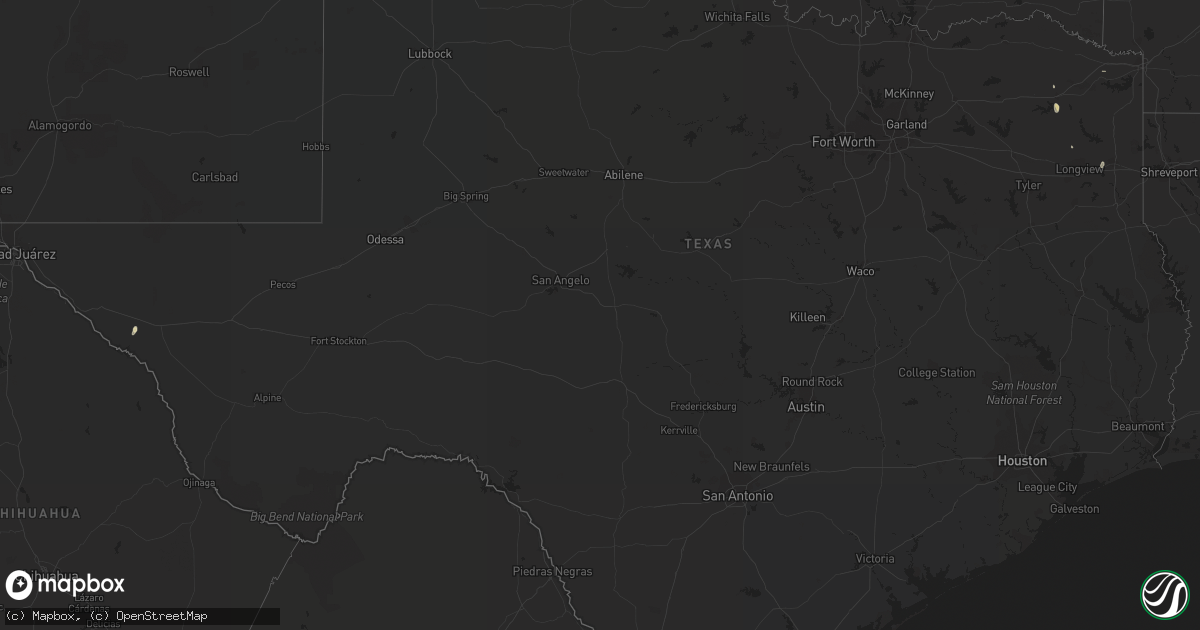
Hail Map in Texas on July 4, 2020
Get this storm
July 4 map
$229
one time, instant access
Download today. No call, no setup
Keep the $229
Bought the map and want the full workflow? Apply the entire $229 to a subscription within 7 days. None of it is wasted.
Every map, not just this one
This buys you this map. Subscription and you get every map we run, in the markets you choose from a few cities to whole states to nationwide. Plus real-time alerts the moment a storm fires.
Contact data
Name, contact info, occupancy, even credit band for addresses in the footprint. You go from where it hit to who to call.
Become the source they trust
Unlimited branding weather history reports on demand. You already have the documented answer ready for the property owner, and you are the one who showed up with it.
Property data and RoofTrace estimates
Pull up any address you have got, its value and the exact code rules for that jurisdiction, straight from One Click Code. Then RoofTrace estimates the squares, pitch, and roof value, priced the way you price.
Storm reports in Texas
Texas
| Date | Description |
|---|---|
| 07/04/20204:23 PM CDT | A local report indicates 64 MPH wind near 4 E PALO DURO (JA) |
| 07/04/20203:52 PM CDT | A picture of the hail was sent to our facebook page. |
| 07/04/20203:50 PM CDT | A local report indicates 1.00 inch wind near PAMPA |
| 07/04/20203:45 PM CDT | A local report indicates 1.00 inch wind near 1 S PAMPA |
| 07/04/20205:14 AM CDT | At 1013 PM CDT, a severe thunderstorm was located 14 miles southeast of Romero, or 18 miles east of Nara Visa, moving east at 40 mph. HAZARD...60 mph wind gusts. SOURCE...Radar indicated. IMPACT...Minor damage to roofs, siding, and trees is possible. Locations impacted include... Vega, Hartley, Channing, Adrian, Boys Ranch, Wildorado and Romero. |
| 07/04/20203:50 AM CDT | Several trees reported down in the hallsville area. |
| 07/04/20203:00 AM CDT | Tree down on 728 on 49 bringing down power lines. Another tree down on 729 west of jefferson. |
| 07/04/20201:25 AM CDT | At 625 PM CDT, a severe thunderstorm was located 8 miles south of Lockett, moving southeast at 10 mph. HAZARD...60 mph wind gusts and quarter size hail. SOURCE...Radar indicated. IMPACT...Hail damage to vehicles is expected. Expect wind damage to roofs, siding, and trees. This severe thunderstorm will remain over mainly rural areas of southwestern Wilbarger County. |
| 07/04/202012:49 AM CDT | At 548 PM CDT, a severe thunderstorm was located 6 miles northwest of Grayback, moving southeast at 5 to 15 mph. HAZARD...60 mph wind gusts and nickel size hail. SOURCE...Radar indicated. IMPACT...Expect damage to roofs, siding, and trees. Locations impacted include... Vernon, Oklaunion, Lockett and Grayback. |
| 07/04/202012:42 AM CDT | At 542 PM CDT, a severe thunderstorm was located 7 miles south of Memphis, moving east at 10 mph. HAZARD...70 mph wind gusts and quarter size hail. SOURCE...Radar indicated. IMPACT...Hail damage to vehicles is expected. Expect considerable tree damage. Wind damage is also likely to mobile homes, roofs, and outbuildings. Locations impacted include... Memphis and Estelline. |
| 07/03/202010:59 PM CDT | At 359 PM CDT, a severe thunderstorm was located near Pampa, moving northeast at 15 mph. HAZARD...Quarter size hail. SOURCE...Radar indicated. IMPACT...Damage to vehicles is expected. Locations impacted include... Pampa, Lefors and Codman. |
| 07/03/202010:16 PM CDT | At 315 PM CDT, a severe thunderstorm was located near Kingsmill, or 6 miles southwest of Pampa, moving northeast at 10 mph. HAZARD...60 mph wind gusts and half dollar size hail. SOURCE...Radar indicated. IMPACT...Minor damage to roofs, siding, and trees is possible. Hail damage to vehicles is expected. Locations impacted include... Pampa, White Deer and Kingsmill. |
| 07/03/202010:06 PM CDT | A local report indicates 71 MPH wind near 11 SSW ROMERO |
All States Impacted by Hail Map on July 4, 2020
Cities Impacted by Hail Map on July 4, 2020
- Colstrip, MT
- Ordway, CO
- Deland, FL
- Circle, MT
- Kulm, ND
- Forbes, ND
- Edgeley, ND
- Ashley, ND
- Fredonia, ND
- Cleveland, ND
- Jamestown, ND
- Scobey, MT
- Nashua, MT
- Fort Peck, MT
- Forsyth, MT
- Santa Rosa, NM
- Wilburn, AR
- Pangburn, AR
- Winter Haven, FL
- Jordan, MT
- Cohagen, MT
- Vinson, OK
- Sierra Blanca, TX
- Aberdeen, SD
- Bowie, MD
- Pampa, TX
- Anniston, AL
- Northport, AL
- Kyle, SD
- Lusk, WY
- Mangum, OK
- Duke, OK
- Dutton, MT
- Wing, ND
- Shamrock, TX
- Westport, SD
- Leola, SD
- Greeley, CO
- La Salle, CO
- Almont, ND
- Ipswich, SD
- Pine Ridge, SD
- Angela, MT
- Titusville, FL
- Christmas, FL
- Highmore, SD
- Tolstoy, SD
- Livermore, CO
- Porcupine, SD
- Lisbon, ND
- Sondheimer, LA
- Jacksonville, AL
- Gladstone, NM
- Edenton, NC
- Musselshell, MT
- Northville, SD
- Cresbard, SD
- Mansfield, SD
- Frazer, MT
- Mount Pleasant, TX
- Bastrop, LA
- Miller, SD
- Wessington Springs, SD
- Gann Valley, SD
- Lehr, ND
- Interior, SD
- Kadoka, SD
- Otter, MT
- Las Vegas, NM
- De Kalb, MS
- Collinsville, MS
- Belle Fourche, SD
- Peerless, MT
- New Salem, ND
- Mandan, ND
- Cook, MN
- Orr, MN
- Thermopolis, WY
- Worland, WY
- Custer, MT
- Whitetail, MT
- Sheldon, ND
- Euclid, MN
- New Boston, TX
- Wellington, TX
- San Jon, NM
- Java, SD
- Hoven, SD
- Bowdle, SD
- Selby, SD
- Wakpala, SD
- Hysham, MT
- Buford, WY
- Laramie, WY
- Stanford, MT
- Edgemont, SD
- Denton, MT
- Buffalo, SD
- Stuttgart, AR
- Model, CO
- Fowler, CO
- Saint Lawrence, SD
- Buchanan, GA
- Candler, NC
- Oak Grove, LA
- Pioneer, LA
- Elgin, ND
- New Leipzig, ND
- Torrington, WY
- Roseau, MN
- Cartwright, ND
- Newton, MS
- Lawrence, MS
- Eureka, SD
- Floral, AR
- Enderlin, ND
- Wessington, SD
- Springer, NM
- Gilmer, TX
- Rockham, SD
- Wannaska, MN
- Middle River, MN
- Gatzke, MN
- Crookston, MN
- Bismarck, ND
- Nara Visa, NM
- Grand Forks, ND
- Sugar City, CO
- Vernon, TX
- Gettysburg, SD
- Lebanon, SD
- Norwood, MO
- Altus, OK
- Tie Siding, WY
- Tchula, MS
- Pittsburg, TX
- Maggie Valley, NC
- Marianna, AR
- Palm Bay, FL
- Loxahatchee, FL
- Zortman, MT
- Lewistown, MT
- Monticello, AR
- Flaxville, MT
- Williston, ND
- Brusett, MT
- Roscoe, SD
- Beech Grove, IN
- Indianapolis, IN
- Long Lake, SD
- Lake Village, AR
- Buchanan, ND
- Raton, NM
- Preston, MS
- Carbon Hill, AL
- Fisher, MN
- Red Lake Falls, MN
- Newfolden, MN
- Lance Creek, WY
- Midland, SD
- Greenville, MS
- Baldwin, ND
- Grygla, MN
- Boaz, AL
- Horton, AL
- Sterling, ND
- Custer, SD
- Viking, MN
- Kentwood, LA
- Lame Deer, MT
- Oral, SD
- Des Moines, NM
- Philadelphia, MS
- Union, MS
- Milton, FL
- Fort Pierce, FL
- Nome, ND
- Roundup, MT
- Camp Crook, SD
- Jonesboro, LA
- Jud, ND
- Chillicothe, TX
- Skowhegan, ME
- Canaan, ME
- Britt, MN
- Hardin, MT
- Kersey, CO
- Glenham, SD
- Mound City, SD
- Waynesville, NC
- Wellington, AL
- Franklin, LA
- Hot Springs, SD
- Bremen, GA
- Indiantown, FL
- East Grand Forks, MN
- Conrad, MT
- Onaka, SD
- Roy, MT
- Scranton, NC
- Belhaven, NC
- Capulin, NM
- Wiggins, MS
- Herreid, SD
- Bald Knob, AR
- Clancy, MT
- La Junta, CO
- Robertsdale, AL
- Smithwick, SD
- Oelrichs, SD
- Wishek, ND
- Leonard, ND
- Sallis, MS
- Olustee, OK
- Pompano Beach, FL
- Worden, MT
- Lead, SD
- Taft, TX
- Jupiter, FL
- Philip, SD
- Lambert, MT
- Richey, MT
- Faulkton, SD
- Belle Glade, FL
- Leicester, NC
- Brady, MT
- Senatobia, MS
- Thompson, ND
- Emerado, ND
- Sardis, MS
- Eldorado, OK
- Wyandotte, OK
- Seneca, MO
- Reva, SD
- Ludlow, SD
- Marshall, TX
- Hallsville, TX
- Oakman, AL
- Steele, ND
- Wolf Point, MT
- Dermott, AR
- Glen Ullin, ND
- Ralph, SD
- Gackle, ND
- Rogersville, MO
- Lambert, MS
- Fellsmere, FL
- Butler, AL
- New Smyrna Beach, FL
- Carson, ND
- Hilger, MT
- Groom, TX
- Upper Marlboro, MD
- Andrews Air Force Base, MD
- Grassy Butte, ND
- Vero Beach, FL
- Crow Agency, MT
- Orient, SD
- Mott, ND
- Sylva, NC
- Cruger, MS
- Lexington, MS
- Aurora, CO
- Downsville, LA
- Palm City, FL
- Kimball, SD
- Milo, ME
- Columbia, LA
- Schlater, MS
- Wyola, MT
- Lodge Grass, MT
- Wellington, CO
- Monteagle, TN
- Hosmer, SD
- Sikes, LA
- Malabar, FL
- Melbourne Beach, FL
- Helena, MT
- East Helena, MT
- Hazen, AR
- Debary, FL
- Orange City, FL
- Deltona, FL
- Jensen Beach, FL
- Stuart, FL
- Port Saint Lucie, FL
- Headrick, OK
- Tumbling Shoals, AR
- Heber Springs, AR
- Eupora, MS
- Frederick, SD
- Miles City, MT
- Anton Chico, NM
- Coral Springs, FL
- Fort Lauderdale, FL
- Jay Em, WY
- Lingle, WY
- Brockton, MT
- Boise City, OK
- Guernsey, WY
- Larkspur, CO
- Terry, MT
- Hedley, TX
- Clinton, MD
- Watson, AR
- Tillar, AR
- Hill City, SD
- Seneca, SD
- Eau Claire, MI
- Ismay, MT
- Batesville, AR
- Chisholm, MN
- Side Lake, MN
- Forbes, MN
- Eveleth, MN
- McLaughlin, SD
- Hayes, SD
- Allen, SD
- Wanblee, SD
- Logan, NM
- Adrian, TX
- Channing, TX
- Vega, TX
- Malta, MT


