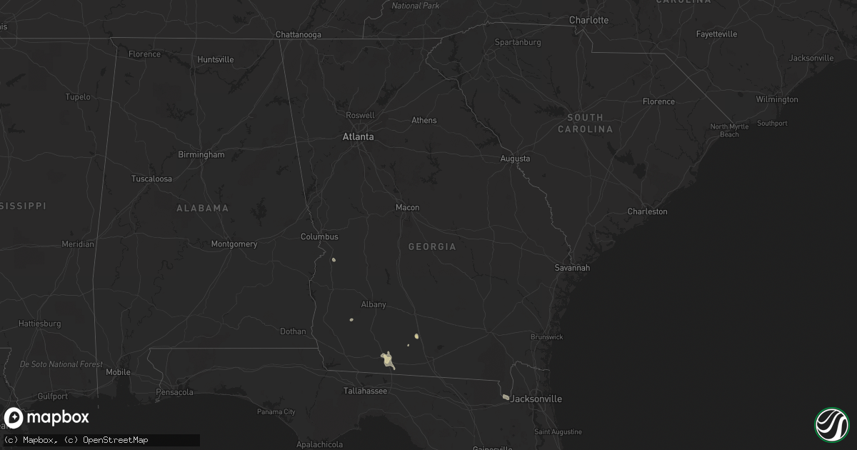
Hail Map in Georgia on July 3, 2020
Get this storm
July 3 map
$229
one time, instant access
Download today. No call, no setup
Keep the $229
Bought the map and want the full workflow? Apply the entire $229 to a subscription within 7 days. None of it is wasted.
Every map, not just this one
This buys you this map. Subscription and you get every map we run, in the markets you choose from a few cities to whole states to nationwide. Plus real-time alerts the moment a storm fires.
Contact data
Name, contact info, occupancy, even credit band for addresses in the footprint. You go from where it hit to who to call.
Become the source they trust
Unlimited branding weather history reports on demand. You already have the documented answer ready for the property owner, and you are the one who showed up with it.
Property data and RoofTrace estimates
Pull up any address you have got, its value and the exact code rules for that jurisdiction, straight from One Click Code. Then RoofTrace estimates the squares, pitch, and roof value, priced the way you price.
Storm reports in Georgia
Georgia
| Date | Description |
|---|---|
| 07/03/20204:42 PM CDT | Multiple streets in thomasville with trees down via thomasville pd facebook. |
| 07/03/202012:42 AM CDT | At 542 PM EDT, severe thunderstorms were located along a line extending from near Thomasville to 11 miles southeast of Monticello, moving south at 20 mph. HAZARD...60 mph wind gusts. SOURCE...Radar indicated. IMPACT...Expect damage to roofs, siding, and trees. Locations impacted include... Monticello, Thomasville, Boston, Ochlocknee, Alma, Dills, Thomasville Municipal A/P, Dillon, Lamont, Everett, Nash, Rocky Hill, Miccosukee, Iamonia, Drifton, Casa Blanco, Waukeenah, Lake Miccosukee, Fincher and Moncrief. |
All States Impacted by Hail Map on July 3, 2020
Cities Impacted by Hail Map on July 3, 2020
- Drayton, ND
- Kendall, KS
- Syracuse, KS
- Watonga, OK
- Selfridge, ND
- Wiley, CO
- Sledge, MS
- Limon, CO
- Chandler, OK
- Great Falls, MT
- Eads, CO
- Kit Carson, CO
- Williston, ND
- Manvel, ND
- Cope, CO
- Ponchatoula, LA
- Morgan City, LA
- Turpin, OK
- Deport, TX
- Bogata, TX
- Carthage, TX
- Adel, GA
- Sparks, GA
- Sheridan Lake, CO
- Wheatland, WY
- Okmulgee, OK
- Scranton, ND
- Bowman, ND
- Hettinger, ND
- Reeder, ND
- Morristown, SD
- Keldron, SD
- Frisco City, AL
- Lindon, CO
- Genoa, CO
- Arriba, CO
- Woodrow, CO
- Brockway, MT
- Volborg, MT
- Clinton, AR
- Center Ridge, AR
- Viking, MN
- Argyle, MN
- Thomasville, GA
- Balko, OK
- Flagler, CO
- Napoleonville, LA
- Labadieville, LA
- Donaldson, MN
- Stratton, CO
- Tahlequah, OK
- Kansas, OK
- Twin Oaks, OK
- Oaks, OK
- Kingfisher, OK
- Buffalo Gap, SD
- Elk Point, SD
- Sardis, MS
- Hugo, CO
- Matheson, CO
- Parker, CO
- Eutaw, AL
- Forsyth, MT
- Beggs, OK
- Weir, MS
- Prairie Du Sac, WI
- Nacogdoches, TX
- Glendive, MT
- Wibaux, MT
- Terry, MT
- Blossom, TX
- Detroit, TX
- Raynesford, MT
- Grover, CO
- Decker, MT
- Otter, MT
- Las Animas, CO
- McClave, CO
- Hasty, CO
- Lemmon, SD
- Billings, MT
- Mitchell, NE
- Circle, MT
- Cohagen, MT
- Cleveland, MO
- Freeman, MO
- Olathe, KS
- Belton, MO
- Spring Hill, KS
- Overland Park, KS
- Peculiar, MO
- Bucyrus, KS
- Stilwell, KS
- Luther, OK
- Harrah, OK
- Wellston, OK
- Fremont, NE
- Macclenny, FL
- Glen Saint Mary, FL
- Saint George, GA
- Vidor, TX
- Silsbee, TX
- Oslo, MN
- Akron, CO
- Clinton, LA
- Ekalaka, MT
- Forest River, ND
- Castle Rock, CO
- Sedalia, CO
- Larkspur, CO
- Booker, TX
- Torrington, WY
- Yoder, WY
- Stephen, MN
- Kennedy, MN
- Bison, SD
- Bushnell, NE
- Colmesneil, TX
- Stroud, OK
- Sparks, OK
- Davenport, OK
- Pittsburg, TX
- Guthrie, OK
- Shawnee, OK
- Sturgeon Lake, MN
- McGrath, MN
- Mcgregor, MN
- McLaughlin, SD
- Laverne, OK
- Reva, SD
- Range, AL
- Joes, CO
- Wakpala, SD
- Marks, MS
- Haworth, OK
- De Queen, AR
- Winthrop, AR
- Des Allemands, LA
- Fairburn, SD
- Hermosa, SD
- Ponca, NE
- Thibodaux, LA
- Rosebud, MT
- Coushatta, LA
- Hall Summit, LA
- Forsyth, MO
- Hilger, MT
- Boyes, MT
- Hammond, MT
- Hugo, OK
- Antlers, OK
- Cameron, LA
- Meade, KS
- Plains, KS
- Paden, OK
- Live Oak, FL
- La Junta, CO
- Leary, GA
- Newton, GA
- Minto, ND
- Fort Morgan, CO
- Carrington, ND
- Lodgepole, SD
- Vona, CO
- Scotland, AR
- Senatobia, MS
- Sarah, MS
- Hardin, MT
- Briggsdale, CO
- McIntosh, SD
- Grafton, ND
- Clayton, NM
- Grenville, NM
- Orange, TX
- Marionville, MO
- Haswell, CO
- Kim, CO
- Bainville, MT
- Jefferson, SD
- Jackson, NE
- Seneca, MO
- Neosho, MO
- Forgan, OK
- Bristow, OK
- Demopolis, AL
- Beresford, SD
- Burbank, SD
- Alcester, SD
- Cleveland, AR
- Winifred, MT
- Carpenter, WY
- Pine Bluffs, WY
- Fairview, MT
- Spencer, OK
- Jones, OK
- Arcadia, OK
- Gillham, AR
- Como, MS
- Edmond, OK
- Cashion, OK
- Miles City, MT
- Camp Crook, SD
- Walnut Ridge, AR
- Kirbyville, TX
- Spurger, TX
- Jasper, TX
- Buna, TX
- Savage, MT
- Rhame, ND
- Amidon, ND
- Grove Hill, AL
- Dillon, MT
- Verona, NJ
- Montclair, NJ
- West Orange, NJ
- Crane, MO
- Billings, MO
- Watauga, SD
- Buffalo, SD
- Fort Scott, KS
- Eufaula, OK
- Wayne, NE
- Wakefield, NE
- Tallulah, LA
- Richards, MO
- Dazey, ND
- Carney, OK
- Hernando, MS
- Ponca City, OK
- Westtown, NY
- Choctaw, OK
- Meeker, OK
- Oklahoma City, OK
- Meridian, OK
- Port Jervis, NY
- Middletown, NY
- Magnolia, MS
- Mccomb, MS
- Moultrie, GA
- Pavo, GA
- Hydro, OK
- Geary, OK
- Hinton, OK
- Mount Pleasant, TX
- Lakin, KS
- Henryetta, OK
- Whatley, AL
- Franklin, AL
- Grygla, MN
- Thorsby, AL
- Summit, MS
- Franklin, LA
- Hawk Springs, WY
- Okemah, OK
- Trumann, AR
- Allenton, WI
- Goldonna, LA
- Coolidge, GA
- Lyman, NE
- Harrisburg, NE
- Kimball, NE
- Dover, AR
- Leesburg, TX
- New England, ND
- Evergreen, AL
- Greenville, FL
- Wolf Point, MT
- Berryville, AR
- Seibert, CO
- Alexander City, AL
- Broadus, MT
- Beaver, OK
- Boligee, AL
- Kirbyville, MO
- Powersite, MO
- Rueter, MO
- French Camp, MS
- McCool, MS
- Russellville, AR
- Cassville, MO
- Dover, OK
- Culbertson, MT
- Guffey, CO
- Garrison, ND
- New Rockford, ND
- Prairie City, SD
- Grand Cane, LA
- Logansport, LA
- Keatchie, LA
- Bristol, FL
- Morristown, NJ
- Cedar Knolls, NJ
- Morris Plains, NJ
- Ethel, MS
- Stewart, MS
- Biddle, MT
- Alzada, MT
- Lead Hill, AR
- Salem, MO
- East Grand Forks, MN
- Eureka Springs, AR
- Atkins, AR
- Hector, AR
- Lagrange, WY
- Shattuck, OK
- Cross Plains, WI
- Mount Horeb, WI
- Grand Forks, ND
- Richland, GA
- Jasper, MO
- Perkins, OK
- Badger, MN
- Greenbush, MN
- Creole, LA
- Lonsdale, AR
- Helena, AR
- Raleigh, MS
- Louin, MS
- Marianna, AR
- Sanderson, FL
- Tecumseh, OK
- Arkadelphia, AR
- Gurdon, AR
- Deerfield, MO
- Karlstad, MN
- Boutte, LA
- Cascade, MT
- Marshall, AR
- Deridder, LA
- Arthur City, TX
- Powderly, TX
- Delhi, LA
- Buford, WY
- Waskom, TX
- Marshall, TX
- Ashland, AL
- Colorado Springs, CO
- Fort Towson, OK
- Royal, AR
- Mountain Pine, AR
- Hot Springs National Park, AR
- Clanton, AL
- Billingsley, AL
- Livingston, AL
- Newfolden, MN
- Strandquist, MN
- Claremore, OK
- Scottsbluff, NE
- Bagwell, TX
- Richfield, KS
- Selma, AL
- Brookeland, TX
- Milton, FL
- Weleetka, OK
- Pottsville, AR
- New Raymer, CO
- Johnson, KS
- Mount Vernon, MO
- Delia, KS
- Emmett, KS
- Dundee, MS
- Nickerson, NE
- Grant, OK
- Shawmut, MT
- Leslie, AR
- Bay, AR
- Lake City, AR
- Warren, MN
- Orangeville, PA
- Mapleton, KS
- Porter, OK
- Coweta, OK
- Newton, TX
- Lamar, MO
- Cumby, TX
- Saint Marys, KS
- Boston, GA
- Bullhead, SD
- Marbury, AL
- Prattville, AL
- Montgomery, LA
- Atlanta, LA
- Lambert, MT
- Enid, OK
- Towaco, NJ
- Douglas, ND
- Welling, OK
- Walnut Shade, MO
- Branson, MO
- Jamestown, LA
- Bell City, LA
- Iowa, LA
- Repton, AL
- Saint Joe, AR
- Greenfield, OK
- Pattonville, TX
- Idabel, OK
- Roswell, NM
- Hot Springs Village, AR
- Pisek, ND
- Verona, WI
- Aguilar, CO
- Queen City, TX
- Golden, MO
- Kilmichael, MS
- Galena, MO
- Cape Fair, MO
- Shell Knob, MO
- Crenshaw, MS
- La Cygne, KS
- Wiggins, CO
- Orchard, CO
- Pleasanton, KS
- Atmore, AL
- Stockett, MT
- Forrest City, AR
- Rattan, OK
- Texarkana, AR
- Piedmont, OK
- Hennessey, OK
- Crescent, OK
- Livingston, NJ
- Cedar Grove, NJ
- Vermillion, SD
- New Underwood, SD
- Millville, PA


