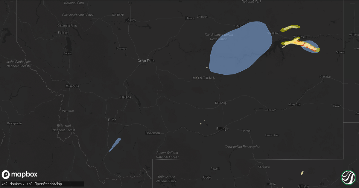
Hail Map in Montana on July 2, 2025
Get this storm
July 2 map
$229
one time, instant access
Download today. No call, no setup
Keep the $229
Bought the map and want the full workflow? Apply the entire $229 to a subscription within 7 days. None of it is wasted.
Every map, not just this one
This buys you this map. Subscription and you get every map we run, in the markets you choose from a few cities to whole states to nationwide. Plus real-time alerts the moment a storm fires.
Contact data
Name, contact info, occupancy, even credit band for addresses in the footprint. You go from where it hit to who to call.
Become the source they trust
Unlimited branding weather history reports on demand. You already have the documented answer ready for the property owner, and you are the one who showed up with it.
Property data and RoofTrace estimates
Pull up any address you have got, its value and the exact code rules for that jurisdiction, straight from One Click Code. Then RoofTrace estimates the squares, pitch, and roof value, priced the way you price.
Storm reports in Montana
Montana
| Date | Description |
|---|---|
| 07/02/20256:45 PM CDT | Mesonet station jpkm8 judith peak raws. Thunderstorm wind gust on wednesday evening. Time of event is estimated. |
| 07/02/20256:45 PM CDT | Mesonet station mtm09 2.1 w moccasin |
| 07/02/20256:15 PM CDT | Corrects previous tstm wnd dmg report from 1 nw lewistown. Public reported on social media that an abandoned lumber shop collapsed due to the thunderstorms with photos |
| 07/02/20256:15 PM CDT | Trees down along the lewistown trail system blocking the trail. Time estimated based on radar. |
| 07/02/20256:10 PM CDT | Public reported on social media that an abandoned lumber shop collapsed due to the thunderstorms with photos of debris across the property. Time estimated based on rada |
| 07/02/20253:15 PM CDT | Mesonet station brrm8 brenner raws. Time of event is estimated. |
| 07/02/20253:14 PM CDT | 74 mph wind gust at the dillon airport. |
| 07/02/20253:07 PM CDT | Estimated wind gust of 58 mph at an ambient weather station... Chicken coop. |
| 07/02/20251:15 AM CDT | Convective outflow wind gust. Little lightning. Mt lebanon mt mesonet site. |
| 07/01/202510:00 PM CDT | St. Marie mt-24 mp 18.0... Mt |
| 07/01/20259:35 PM CDT | A local report indicates 63 MPH wind near 4 ENE Vida |
| 07/01/20259:15 PM CDT | Mesonet station gw1852 tiber marina. |
| 07/01/20259:10 PM CDT | Saco s |
| 07/01/20259:08 PM CDT | South sawmill creek. |
| 07/01/20258:45 PM CDT | 60 mph thunderstorm wind gust on wednesday evening at brady ne montana mesonet site. |
| 07/01/20258:41 PM CDT | Manning corral dogtown... Mt |
| 07/01/20258:30 PM CDT | Multiple cottonwood trees have limb damage... Wick |
| 07/01/20258:30 PM CDT | Multiple cottonwood trees have limb damage... Wicked lightning... Estimated winds 55-60 mph... Lots of rain. |
| 07/01/20258:19 PM CDT | Asos station khln helena airport. |
| 07/01/20258:15 PM CDT | 65 mph wind gust at midway colony mt mesonet site. |
| 07/01/20258:13 PM CDT | Awos station k1gm golf. |
| 07/01/20257:56 PM CDT | Awos station k1hm 6 nne fairfield. |
| 07/01/20257:55 PM CDT | 59 mph thunderstorm wind gust on wednesday evening at bynum w mt mesonet site. |
| 07/01/20257:45 PM CDT | 67 mph thunderstorm wind gust on wednesday evening at augusta n hydromet mt mesonet site. |
| 07/01/20257:00 PM CDT | Estimated wind gusts near 60 mph with a thunderstorm on wednesday evening. Time of event is estimated. |
All States Impacted by Hail Map on July 2, 2025
Cities Impacted by Hail Map on July 2, 2025
- Alliance, NE
- Ellsworth, NE
- Moyock, NC
- Knotts Island, NC
- Patagonia, AZ
- Nogales, AZ
- Orrum, NC
- Sonoita, AZ
- Dillon, MT
- Twin Bridges, MT
- Sheridan, MT
- Vail, AZ
- Tumacacori, AZ
- Tomahawk, WI
- Irma, WI
- Amado, AZ
- Mayer, AZ
- Tubac, AZ
- Wittenberg, WI
- Hatley, WI
- Green Valley, AZ
- Eland, WI
- Rosholt, WI
- Rapelje, MT
- Flint, MI
- Broadview, MT
- Polkton, NC
- Iola, WI
- Tigerton, WI
- Caro, MI
- Unionville, MI
- South Lake Tahoe, CA
- Lane, SC
- Canton, MN
- Minong, WI
- Lewistown, MT
- Decorah, IA
- Trego, WI
- Byron, MN
- Rochester, MN
- Ridgeway, IA
- Roy, MT
- Spring Valley, MN
- Bouse, AZ
- Salome, AZ
- Springbrook, WI
- Spooner, WI
- Deckerville, MI
- Calmar, IA
- Le Roy, MN
- Vassar, MI
- Chester, IA
- Lime Springs, IA
- Sells, AZ
- Fort Atkinson, IA
- Fort Peck, MT
- Nashua, MT
- Wolf Point, MT
- Frazer, MT
- Allendale, SC
- Peerless, MT
- Valier, MT
- Conrad, MT
- Gillette, WY
- Questa, NM
- San Cristobal, NM
- Vida, MT
- Saint Matthews, SC
- Winifred, MT
- Zortman, MT
- Hays, MT
- Winnett, MT
- Malta, MT
- Jordan, MT
- Brusett, MT
- Dodson, MT
- Buckeye, AZ
- Buffalo, WY
- Arlington, AZ
- Tonopah, AZ
- Richey, MT
- Poplar, MT
- Palo Verde, AZ
- Lambert, MT
- Saco, MT
- Hinsdale, MT
- Vandalia, MT
- Glasgow, MT
- Honea Path, SC
- Ware Shoals, SC
- Essex, MT
- Tecopa, CA
- Tripp, SD
- Hayward, WI
- Olivet, SD
- Menno, SD
- Freeman, SD
- Marion, SD
- Wakonda, SD
- Centerville, SD
- Vermillion, SD
- Beresford, SD
- Buffalo, SD
- Ludlow, SD
- Reva, SD
- Ralph, SD
- Hettinger, ND
- Mott, ND
- New England, ND


