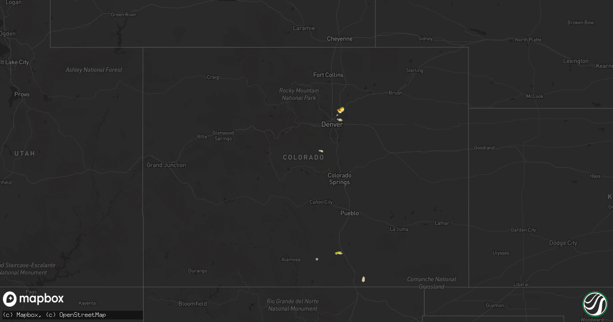
Hail Map in Colorado on July 2, 2021
Get this storm
July 2 map
$229
one time, instant access
Download today. No call, no setup
Keep the $229
Bought the map and want the full workflow? Apply the entire $229 to a subscription within 7 days. None of it is wasted.
Every map, not just this one
This buys you this map. Subscription and you get every map we run, in the markets you choose from a few cities to whole states to nationwide. Plus real-time alerts the moment a storm fires.
Contact data
Name, contact info, occupancy, even credit band for addresses in the footprint. You go from where it hit to who to call.
Become the source they trust
Unlimited branding weather history reports on demand. You already have the documented answer ready for the property owner, and you are the one who showed up with it.
Property data and RoofTrace estimates
Pull up any address you have got, its value and the exact code rules for that jurisdiction, straight from One Click Code. Then RoofTrace estimates the squares, pitch, and roof value, priced the way you price.
Storm reports in Colorado
Colorado
| Date | Description |
|---|---|
| 07/02/20211:42 AM CDT | At 642 PM MDT, a severe thunderstorm was located near Brighton, or 20 miles northeast of Denver, moving northeast at 5 mph. Additional strong to severe storms are expected to develop towards the southwest along I-76. HAZARD...Quarter size hail. SOURCE...Radar indicated. IMPACT...Damage to vehicles is expected. Locations impacted include... Thornton, northeastern Westminster, Commerce City, Northglenn, Brighton, northern Denver International Airport, Lochbuie, Hudson, Barr Lake and Todd Creek. |
| 07/02/202112:55 AM CDT | At 555 PM MDT, a severe thunderstorm was located near Walsenburg, or 23 miles east of Spring Burn Scar north of Highway 160, moving southeast at 5 mph. HAZARD...60 mph wind gusts and quarter size hail. SOURCE...Radar indicated. IMPACT...Hail damage to vehicles is expected. Expect wind damage to roofs, siding, and trees. Locations impacted include... Walsenburg. |
| 07/02/202112:30 AM CDT | At 529 PM MDT, a severe thunderstorm was located near La Veta, or 12 miles east of Spring Burn Scar south of Highway 160 in Huerfano county, moving east at 10 mph. HAZARD...60 mph wind gusts and half dollar size hail. SOURCE...Radar indicated. IMPACT...Hail damage to vehicles is expected. Expect wind damage to roofs, siding, and trees. Locations impacted include... Walsenburg and La Veta. |
| 07/02/202112:06 AM CDT | At 506 PM MDT, a severe thunderstorm was located near Fort Garland, or 7 miles southwest of Spring Burn Scar south of Highway 160 in Costilla county, moving south at 15 mph. HAZARD...60 mph wind gusts and half dollar size hail. SOURCE...Radar indicated. IMPACT...Hail damage to vehicles is expected. Expect wind damage to roofs, siding, and trees. Locations impacted include... Southwestern Spring Burn Scar south of Highway 160 in Costilla county. |
| 07/01/20217:55 PM CDT | A local report indicates 1.75 inch wind near BRIGHTON |
| 07/01/20217:53 PM CDT | Report from mping: quarter |
| 07/01/20217:50 PM CDT | Report from mping: half dollar |
All States Impacted by Hail Map on July 2, 2021
Cities Impacted by Hail Map on July 2, 2021
- Manville, WY
- Lusk, WY
- Glendo, WY
- Jay Em, WY
- Torrington, WY
- Shawnee, WY
- Walsenburg, CO
- Edgemont, SD
- Lance Creek, WY
- Belle Fourche, SD
- Warwick, NY
- Monroe, NY
- Florida, NY
- Chester, NY
- Upton, WY
- Friendsville, PA
- Brackney, PA
- Brighton, CO
- East Smithfield, PA
- Ulster, PA
- Columbia Cross Roads, PA
- Milan, PA
- Newcastle, WY
- Sundance, WY
- Osage, WY
- Moorcroft, WY
- Goldthwaite, TX
- Athens, PA
- Seminole, TX
- Tombstone, AZ
- Elfrida, AZ
- Hewitt, TX
- Lorena, TX
- Alzada, MT
- Fort Garland, CO
- Hammond, MT
- Hill City, SD
- Custer, SD
- Mountainair, NM
- Rome, PA
- Hallstead, PA
- Little Meadows, PA
- New Milford, PA
- Towanda, PA
- Warren Center, PA
- Wysox, PA
- Montrose, PA
- Le Raysville, PA
- Wyalusing, PA
- Trinidad, CO
- Trinchera, CO
- Buffalo, SD
- Kermit, TX
- Waco, TX
- Eola, TX
- Defuniak Springs, FL
- Oneonta, NY
- Maryland, NY
- Oracle, AZ
- Kingsley, PA
- Harford, PA
- Henderson, CO
- Ballinger, TX
- Gillett, PA
- Sedalia, CO
- Hackettstown, NJ
- Great Meadows, NJ
- Davenport, NY
- Mullin, TX
- Flasher, ND
- Denver, CO
- Aurora, CO
- Commerce City, CO
- Carlton, TX
- Hamilton, TX
- Highland Mills, NY
- Troy, PA
- Tucson, AZ
- Sells, AZ
- Schenevus, NY
- Central Valley, NY
- Granbury, TX
- Wink, TX
- Rozet, WY
- Gillette, WY


