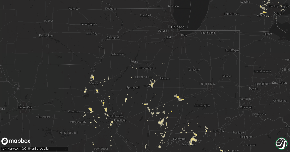
Hail Map in Illinois on July 2, 2012
Get this storm
July 2 map
$229
one time, instant access
Download today. No call, no setup
Keep the $229
Bought the map and want the full workflow? Apply the entire $229 to a subscription within 7 days. None of it is wasted.
Every map, not just this one
This buys you this map. Subscription and you get every map we run, in the markets you choose from a few cities to whole states to nationwide. Plus real-time alerts the moment a storm fires.
Contact data
Name, contact info, occupancy, even credit band for addresses in the footprint. You go from where it hit to who to call.
Become the source they trust
Unlimited branding weather history reports on demand. You already have the documented answer ready for the property owner, and you are the one who showed up with it.
Property data and RoofTrace estimates
Pull up any address you have got, its value and the exact code rules for that jurisdiction, straight from One Click Code. Then RoofTrace estimates the squares, pitch, and roof value, priced the way you price.
Storm reports in Illinois
Illinois
| Date | Description |
|---|---|
| 07/02/20126:15 PM CDT | Trees down and shingles off roofs in city of quincy |
| 07/02/20124:23 PM CDT | A local report indicates 1.00 inch wind near 4 NW RAMSEY |
| 07/02/20123:37 PM CDT | A local report indicates 1.00 inch wind near 3 E SPRINGERTON |
| 07/02/20123:35 PM CDT | A local report indicates 60 MPH wind near 3 E HARRISBURG |
| 07/02/20123:10 PM CDT | The hail was accompanied by at least 70 mph winds. |
| 07/02/20122:03 PM CDT | 70 mph wind estimated. Quarter sized hail. Tree limbs and possibly some trees falling into power lines. |
| 07/02/20122:00 PM CDT | 1 inch hail. Est 50 mph wind heavy rain. In herrin |
All States Impacted by Hail Map on July 2, 2012
Cities Impacted by Hail Map on July 2, 2012
- Wellsville, MO
- Montgomery City, MO
- Pequot Lakes, MN
- New London, WI
- Weyauwega, WI
- Rinard, IL
- Cisne, IL
- Fairfield, IL
- Noble, IL
- Johnsonville, IL
- Clay City, IL
- Philadelphia, TN
- Kingston, TN
- Crossville, TN
- Nunnelly, TN
- Dickson, TN
- Sebeka, MN
- Menahga, MN
- Huntingburg, IN
- Gerald, MO
- Rosebud, MO
- Broadwater, NE
- Nashwauk, MN
- Weldona, CO
- McMillan, MI
- Scottsville, KY
- Bowling Green, KY
- Alvaton, KY
- Adams, TN
- Cedar Hill, TN
- Langdon, ND
- Morrison, MO
- Hermann, MO
- Pikeville, TN
- Vesta, MN
- Lucan, MN
- Crandon, WI
- Laona, WI
- Grant, MI
- Oblong, IL
- Eveleth, MN
- Gilbert, MN
- Mountain Iron, MN
- Iron, MN
- Virginia, MN
- Buffalo, SD
- Mason City, IL
- Moulton, AL
- Interlachen, FL
- Toivola, MI
- Camden, IL
- Mount Sterling, IL
- Stuart, FL
- Black River, MI
- Ossineke, MI
- Morgantown, KY
- Lewisburg, KY
- Naytahwaush, MN
- Waubun, MN
- Mahnomen, MN
- Ludlow, SD
- Hinckley, MN
- Pine City, MN
- Brook Park, MN
- Madisonville, KY
- Perronville, MI
- Argenta, IL
- Decatur, IL
- Oreana, IL
- Columbia, TN
- Limon, CO
- Kaukauna, WI
- Greenleaf, WI
- Annandale, MN
- South Haven, MN
- Litchfield, MN
- Cosmos, MN
- Hutchinson, MN
- Fort McCoy, FL
- Tremont, IL
- Colfax, WA
- Energy, IL
- Carterville, IL
- Herrin, IL
- Boyes, MT
- Biddle, MT
- Pelkie, MI
- Milton, FL
- Jay, FL
- Crystal Falls, MI
- Iron River, MI
- Grove City, MN
- Atwater, MN
- Ottertail, MN
- Swartz Creek, MI
- Flint, MI
- Flushing, MI
- Rapid City, MI
- Buffalo, MN
- Cookeville, TN
- Monterey, TN
- Morley, MI
- Stanwood, MI
- Knoxville, TN
- Spencer, TN
- Melrose, MN
- Freeport, MN
- Albany, MN
- Fosston, MN
- Winger, MN
- Bejou, MN
- Stanley, ND
- Ashley, MI
- Ithaca, MI
- Ellsworth, NE
- Ashby, NE
- Lakeside, NE
- Merriman, NE
- O'Fallon, MO
- Wentzville, MO
- Lake Saint Louis, MO
- Stoneham, CO
- Lewis, IN
- Jasonville, IN
- Winfield, MO
- Troy, MO
- Moscow Mills, MO
- Foley, MO
- Ballwin, MO
- Wildwood, MO
- Eureka, MO
- Sand Lake, MI
- Howard City, MI
- Davison, MI
- Melrose, FL
- Florahome, FL
- Keystone Heights, FL
- Barnesville, MN
- Pelican Rapids, MN
- Rothsay, MN
- Trenton, MI
- Riverview, MI
- Grosse Ile, MI
- Owensboro, KY
- Medford, WI
- Bonduel, WI
- Pulaski, WI
- Shiocton, WI
- Bowling Green, MO
- Eden Valley, MN
- Watkins, MN
- Rhinelander, WI
- Armstrong Creek, WI
- Wabeno, WI
- Gleason, WI
- Pearson, WI
- Summit Lake, WI
- Elcho, WI
- Deerbrook, WI
- Townsend, WI
- Argonne, WI
- Pelican Lake, WI
- White Lake, WI
- Lakeview, MI
- Lynnville, TN
- Culleoka, TN
- Wood, SD
- Gurley, NE
- Dalton, NE
- Pickett, WI
- Winneconne, WI
- Oshkosh, WI
- Van Dyne, WI
- Eldorado, WI
- Omro, WI
- Crab Orchard, TN
- Citra, FL
- Reddick, FL
- Celina, TN
- Moss, TN
- Greenbush, MN
- Brainerd, MN
- New Florence, MO
- Canton, MO
- Warsaw, IL
- Ursa, IL
- Towner, ND
- Meeteetse, WY
- New York Mills, MN
- Northome, MN
- Remus, MI
- Mecosta, MI
- Fort Morgan, CO
- Trout Creek, MI
- Palisade, MN
- Mcgregor, MN
- Jacobson, MN
- Elberfeld, IN
- Haubstadt, IN
- Saint Joseph, MN
- Avon, MN
- Cold Spring, MN
- Ironton, MN
- Oak Park, MN
- Becker, MN
- Crosby, MN
- Elk River, MN
- Wadena, MN
- Wolverton, MN
- Dent, MN
- Erhard, MN
- Pease, MN
- Fort Ripley, MN
- Isle, MN
- Hillman, MN
- Foreston, MN
- Onamia, MN
- Pierz, MN
- Deerwood, MN
- Wahkon, MN
- Little Falls, MN
- Pine River, MN
- Deer Creek, MN
- Vergas, MN
- Browerville, MN
- Hewitt, MN
- Clear Lake, MN
- Frazee, MN
- Henning, MN
- Milaca, MN
- Royalton, MN
- Bertha, MN
- Aldrich, MN
- Foley, MN
- Merrifield, MN
- Randall, MN
- Motley, MN
- Bluffton, MN
- Perham, MN
- Verndale, MN
- Aitkin, MN
- Garrison, MN
- Big Lake, MN
- Princeton, MN
- Staples, MN
- Zimmerman, MN
- Nisswa, MN
- Baxter, MN
- Pillager, MN
- Richville, MN
- Cushing, MN
- Clarissa, MN
- Bemidji, MN
- Mammoth Cave, KY
- Cub Run, KY
- Clarkson, KY
- Two Harbors, MN
- Silver Bay, MN
- Ponsford, MN
- Ogema, MN
- Callaway, MN
- Mountain Grove, MO
- Milltown, IN
- Leavenworth, IN
- Farina, IL
- Potter, NE
- Six Lakes, MI
- Little River, AL
- Clearwater, MN
- Tomahawk, WI
- Greenville, MO
- Clubb, MO
- Glenallen, MO
- Gresham, WI
- Chatsworth, IL
- Rolette, ND
- Mylo, ND
- Willow City, ND
- Nisula, MI
- Dunlap, TN
- Kettle River, MN
- Laporte, MN
- Mora, MN
- Ogilvie, MN
- Cass Lake, MN
- Grantsburg, WI
- Irma, WI
- Clinton Township, MI
- Mount Clemens, MI
- Wabasso, MN
- Rodney, MI
- Big Rapids, MI
- Alma, MI
- Garfield, WA
- Farmington, WA
- Palm City, FL
- Hamilton, ND
- Chisholm, MN
- Battletown, KY
- Maple Lake, MN
- Brighton, MI
- Howell, MI
- Bingham, IL
- Ramsey, IL
- Oconee, IL
- Cerro Gordo, IL
- White Bluff, TN
- Charlotte, TN
- Empire, MI
- Maple City, MI
- Erie, ND
- Holly, MI
- Grand Blanc, MI
- Micanopy, FL
- Robertsdale, AL
- Cody, NE
- Ekalaka, MT
- Camp Crook, SD
- Capitol, MT
- Whitwell, TN
- Whitleyville, TN
- Monticello, IL
- New Haven, MO
- Labelle, FL
- Belcourt, ND
- Marenisco, MI
- Walker, LA
- Oakland City, IN
- Blackduck, MN
- Carmi, IL
- Enfield, IL
- Nebo, IL
- Moose Lake, MN
- Bear Creek, WI
- Clintonville, WI
- Lamberton, MN
- Sebree, KY
- Lakewood, IL
- Alexandria, SD
- Smiths Grove, KY
- Oakland, KY
- Albion, IL
- Marion, AL
- Sanford, MI
- Midland, MI
- Whitmore Lake, MI
- Ann Arbor, MI
- Plymouth, MI
- South Lyon, MI
- Elberta, AL
- Foley, AL
- New Raymer, CO
- Marshall, IL
- Paris, IL
- Bisbee, ND
- Bellaire, MI
- Kewadin, MI
- Central Lake, MI
- Sturgeon Lake, MN
- Depauw, IN
- Monroe City, MO
- Sidney, NE
- Martinsburg, MO
- Oakdale, TN
- Harriman, TN
- Rockfield, KY
- Alden, MI
- Larsen, WI
- South Pittsburg, TN
- Bridgeport, AL
- Sewanee, TN
- Lake, MI
- Clare, MI
- Farwell, MI
- Ashland City, TN
- Eolia, MO
- Sweetwater, TN
- Embarrass, WI
- Neenah, WI
- Manawa, WI
- Marion, WI
- Fond Du Lac, WI
- Fremont, WI
- Hortonville, WI
- Butte Des Morts, WI
- Ogdensburg, WI
- Tigerton, WI
- Shawano, WI
- New Haven, KY
- Hodgenville, KY
- Rockwood, TN
- Sears, MI
- Evart, MI
- Barryton, MI
- Adams, ND
- Lawton, ND
- Lankin, ND
- Sandstone, MN
- Askov, MN
- Bruno, MN
- West Liberty, IL
- Otwell, IN
- Winslow, IN
- Minneapolis, MN
- Flomaton, AL
- Suttons Bay, MI
- Lake Leelanau, MI
- Northport, MI
- Evanston, IN
- Bristow, IN
- Tell City, IN
- Saint Meinrad, IN
- Ferdinand, IN
- Chassell, MI
- Doniphan, MO
- Grandin, MO
- Effingham, IL
- Parrish, AL
- Jasper, AL
- Parmelee, SD
- Gladwin, MI
- Beaverton, MI
- Annapolis, MO
- Seney, MI
- Newberry, MI
- Wiggins, CO
- Wirt, MN
- Max, MN
- Lake City, MI
- Manton, MI
- Lapeer, MI
- Ada, MN
- Twin Valley, MN
- Pekin, IL
- Hawesville, KY
- Cando, ND
- Roseau, MN
- Elsberry, MO
- Glasgow, KY
- Rushville, IL
- Mount Pleasant, MI
- Elsie, MI
- Henderson, MI
- Oakley, MI
- Gainesboro, TN
- Inglis, FL
- Quinton, AL
- Paris, MO
- Hunnewell, MO
- Fife Lake, MI
- Grey Eagle, MN
- Sauk Centre, MN
- Belton, KY
- Rochester, KY
- Drakesboro, KY
- Dunmor, KY
- Fulton, MO
- Steedman, MO
- Redford, MO
- Gaastra, MI
- Hill City, MN
- Swatara, MN
- Solway, MN
- Park Rapids, MN
- Lebanon, KY
- Lynnville, IN
- Crescent City, FL
- Georgetown, FL
- Northville, MI
- Salem, MO
- Cook Sta, MO
- McLeansboro, IL
- Gary, MN
- Trufant, MI
- Pierson, MI
- Coral, MI
- Hawthorne, FL
- Reeder, ND
- Scranton, ND
- McEwen, TN
- Jasper, TN
- Gamaliel, KY
- Lafayette, TN
- Tucson, AZ
- Tensed, ID
- Plummer, ID
- Desmet, ID
- Saint Maries, ID
- Harrison, ID
- Avon Park, FL
- Red Boiling Springs, TN
- Tompkinsville, KY
- Fenton, MI
- Williams, MN
- Watton, MI
- Central, IN
- Mauckport, IN
- Strathcona, MN
- Immokalee, FL
- Ralph, SD
- Newton, IL
- Hector, MN
- Buffalo Lake, MN
- Three Lakes, WI
- Danbury, WI
- Maringouin, LA
- Crosslake, MN
- Herod, IL
- Equality, IL
- Harrisburg, IL
- Brownstown, IL
- Saint Elmo, IL
- Marengo, IN
- English, IN
- Lengby, MN
- Bagley, MN
- White River, SD
- Blackwell, MO
- Briggsdale, CO
- Toledo, IL
- Corunna, MI
- Lennon, MI
- New Lothrop, MI
- Owosso, MI
- Milford, MI
- Highland, MI
- Commerce Township, MI
- Stockton, AL
- Eagle River, WI
- Phelps, WI
- Millwood, KY
- Williamsville, MO
- McGrath, MN
- Summerdale, AL
- Grand Bay, AL
- Soddy Daisy, TN
- Hettinger, ND
- Worley, ID
- Bronson, FL
- Williston, FL
- Morriston, FL
- West Terre Haute, IN
- Terre Haute, IN
- Dennison, IL
- Chesaning, MI
- New Hudson, MI
- Sebring, FL
- Finland, MN
- Shevlin, MN
- Puposky, MN
- Traverse City, MI
- Gwinn, MI
- Saint Cloud, MN
- Kelliher, MN
- Ellery, IL
- Padroni, CO
- Allouez, MI
- Calumet, MI
- Signal Mountain, TN
- Rock Island, TN
- Dix, NE
- Ontonagon, MI
- Leland, MI
- Daphne, AL
- Fairhope, AL
- Cowden, IL
- Herrick, IL
- Nokomis, IL
- Hammond, MT
- Alzada, MT
- Palmyra, IL
- Edmore, MI
- Vestaburg, MI
- Bannister, MI
- Elwell, MI
- North Star, MI
- Brant, MI
- Riverdale, MI
- Breckenridge, MI
- Sumner, MI
- Newaygo, MI
- White Cloud, MI
- Stanton, MI
- Rice Lake, WI
- Birchwood, WI
- Chetek, WI
- Bruce, WI
- Weyerhaeuser, WI
- West Salem, IL
- Atlantic Mine, MI
- Irons, MI
- Bruce Crossing, MI
- Wausau, WI
- Lutsen, MN
- Dahlgren, IL
- Kalkaska, MI
- Pleasant View, TN
- Olivia, MN
- Punta Gorda, FL
- Lake George, MN
- Olney, IL
- Wellston, MI
- Farragut, TN
- Broadus, MT
- Indiantown, FL
- Cokato, MN
- Grandview, IN
- Lewisport, KY
- Maceo, KY
- Rockport, IN
- Fifty Lakes, MN
- Haleyville, AL
- Burton, MI
- Salem, IL
- Malone, WI
- Lebanon, TN
- Hines, MN
- Backus, MN
- Cavalier, ND
- Warrenton, MO
- Spooner, WI
- Trego, WI
- Sullivan, IL
- Hannah, ND
- Caroline, WI
- Mokane, MO
- Norris City, IL
- Hayward, WI
- Detroit Lakes, MN
- Osage, MN
- Penrose, CO
- Rochert, MN
- Armour, SD
- Huntsville, IL
- Cabool, MO
- Berger, MO
- Louisville, IL
- Bingham, NE
- Stewart, MN
- Squaw Lake, MN
- Talmoon, MN
- Deer River, MN
- Bigfork, MN
- Spring Lake, MN
- Dexter, MI
- Cisco, IL
- Maroa, IL
- De Land, IL
- Kinney, MN
- Side Lake, MN
- Hibbing, MN
- Cook, MN
- Hannibal, MO
- Hull, IL
- New London, MO
- Moss Point, MS
- Perrinton, MI
- Saint Johns, MI
- Baraga, MI
- Sidnaw, MI
- Palatka, FL
- Park Falls, WI
- Emily, MN
- Mason, IL
- Wakefield, MI
- Oakfield, WI
- Richmond, MN
- Waite Park, MN
- Pierson, FL
- Conrath, WI
- Makanda, IL
- Carbondale, IL
- Loxley, AL
- Conover, WI
- Weldon, IL
- Felda, FL
- Crystal, MI
- Cantonment, FL
- Ironton, MO
- Providence, KY
- Salol, MN
- Geddes, SD
- Springfield, TN
- Virden, IL
- Waverly, IL
- Gonzales, LA
- Prairieville, LA
- Hettick, IL
- Carlinville, IL
- Emden, MO
- Howard Lake, MN
- Waverly, MN
- Cumberland Furnace, TN
- Corydon, IN
- Roberts, IL
- Roosevelt, MN
- Warroad, MN
- Century, FL
- Denham Springs, LA
- Hersey, MI
- Foristell, MO
- Lancing, TN
- Burnt Prairie, IL
- Marion, IL
- Fremont, MI
- Uniontown, AL
- Poplarville, MS
- Defiance, MO
- Merritt, MI
- Falmouth, MI
- Wrenshall, MN
- Grand Marais, MN
- Leslie, MO
- Beaufort, MO
- Leitchfield, KY
- Santa Claus, IN
- Franklinton, LA
- Mount Hermon, LA
- Mount Erie, IL
- Harrison, MI
- Pacific, MO
- Springerton, IL
- Quincy, IL
- Camp Point, IL
- Edgewood, IL
- Watersmeet, MI
- Holdingford, MN
- Lacrosse, WA
- Land O'Lakes, WI
- Clearbrook, MN
- Rush, CO
- Venus, FL
- Saint Germain, WI
- Long Lake, WI
- Milroy, MN
- Olmstead, KY
- South Pekin, IL
- Lake Lillian, MN
- Bird Island, MN
- Wixom, MI
- Francisco, IN
- Mount Pleasant, TN
- Tustin, MI
- Grosse Pointe, MI
- Saint Clair Shores, MI
- Tennyson, IN
- Weidman, MI
- Pomona Park, FL
- Bryant, WI
- Pickerel, WI
- Wayne City, IL
- Tamarack, MN
- Ventress, LA
- International Falls, MN
- Cedar, MI
- French Lick, IN
- Dubois, IN
- Oak Ridge, TN
- Hay Springs, NE
- Pittsfield, IL
- Wales, ND
- Walhalla, ND
- Seville, FL
- Holton, MI
- Twin Lake, MI
- Clayton, IL
- Hixson, TN
- Chattanooga, TN
- Pembina, ND
- Littlefork, MN
- Bowlus, MN
- Rice, MN
- Saint Francisville, LA
- Maywood, MO
- Altamont, IL
- Bailey, MI
- Beaver Dam, KY
- Osseo, MN
- Champlin, MN
- Maple Grove, MN
- Greensboro, AL
- Livingston, TN
- Hilham, TN
- Sumiton, AL
- Ewen, MI
- Bridgeport, NE
- Bismarck, MO
- Coden, AL
- Selma, AL
- Muskegon, MI
- Greenup, IL
- Nashville, TN
- Franklin, TN
- Omaha, IL
- Kimball, MN
- Marion, MI
- Marcell, MN
- Cromwell, KY
- Auburn, MI
- Monticello, MN
- Montrose, IL
- Jewett, IL
- Wheeler, IL
- Nauvoo, AL
- Lynn, AL
- Carbon Hill, AL
- Dora, AL
- Chrisney, IN
- Lamar, IN
- Philpot, KY
- Cannelton, IN
- Redwood Falls, MN
- Sheridan, MI
- Blanchard, MI
- Kentwood, LA
- Amite, LA
- Mcminnville, TN
- Theodore, AL
- Irvington, AL
- Bayou La Batre, AL
- Leroy, MI
- Burt, MI
- Nevis, MN
- Wolford, ND
- York, ND
- Loudon, TN
- Saint Louis, MI
- Barnum, MN
- Holyoke, MN
- Matheson, CO
- Dassel, MN
- Lanse, MI
- Neche, ND
- Pound, WI
- Crivitz, WI
- Davisburg, MI
- Clarkston, MI
- Ortonville, MI
- Eglin Afb, FL
- Ridgway, IL
- Bon Aqua, TN
- Clarksville, MO
- Silex, MO
- Cataldo, ID
- Lake Placid, FL
- Gretna, LA
- Merino, CO
- Saint Peter, IL
- Kinmundy, IL
- Belleville, MI
- Adairville, KY
- Byers, CO
- Goodrich, MI
- Sparta, TN
- Girard, IL
- Lewiston, MI
- Mulga, AL
- Adamsville, AL
- Cordova, AL
- Sterling, CO
- Bloomer, WI
- Flora, IL
- Geff, IL
- Dawson Springs, KY
- Freeland, MI
- Badger, MN
- Lewisburg, TN
- Beulah, MI
- Honor, MI
- Hestand, KY
- Edmore, ND
- Kerrick, MN
- Caneyville, KY
- Amasa, MI
- Nogales, AZ
- White Lake, MI
- Washington, MI
- Utica, MI
- Potlatch, ID
- Bay City, MI
- Butler, AL
- Ten Mile, TN
- Mineral Point, MO
- Marion Junction, AL
- Webster, WI
- Fence, WI
- Fort Branch, IN
- Farmer City, IL
- Darwin, MN
- Rosebush, MI
- Brimson, MN
- La Grange, MO
- Livonia, LA
- Eldorado, IL
- Boonville, IN
- Rio Rico, AZ
- Uriah, AL
- Robertsville, MO
- Catawissa, MO
- Atlas, MI
- Nebo, KY
- Liberty, IL
- Medora, IL
- Harper Woods, MI
- Detroit, MI
- Oakman, AL
- Elk Rapids, MI
- Williamsburg, MI
- Black Creek, WI
- Frisco City, AL
- Grandview, TN
- Wartburg, TN
- Ypsilanti, MI
- Townley, AL
- Lisco, NE
- Hoyt Lakes, MN
- Aurora, MN
- Biwabik, MN
- Carson City, MI
- Middleton, MI
- Shepherd, MI
- Pompeii, MI
- Appomattox, VA
- Gladstone, VA
- Yale, IL
- Stillwater, MN
- Graysville, TN
- Mass City, MI
- Covington, MI
- Lyles, TN
- Primm Springs, TN
- Saint Michael, MN
- Annapolis, IL
- Park City, KY
- Erskine, MN
- Hazelhurst, WI
- Whitman, NE
- Pensacola, FL
- Holland, KY
- Seaforth, MN
- Hanson, KY
- Gallion, AL
- Louisiana, MO


