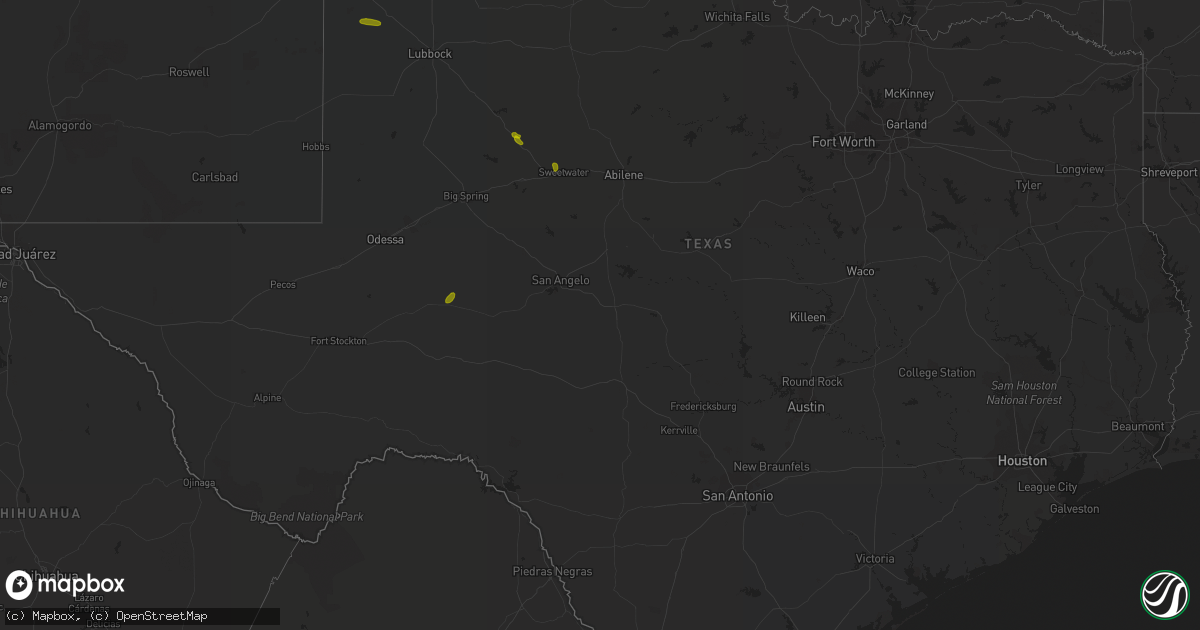
Hail Map in Texas on July 1, 2018
Get this storm
July 1 map
$229
one time, instant access
Download today. No call, no setup
Keep the $229
Bought the map and want the full workflow? Apply the entire $229 to a subscription within 7 days. None of it is wasted.
Every map, not just this one
This buys you this map. Subscription and you get every map we run, in the markets you choose from a few cities to whole states to nationwide. Plus real-time alerts the moment a storm fires.
Contact data
Name, contact info, occupancy, even credit band for addresses in the footprint. You go from where it hit to who to call.
Become the source they trust
Unlimited branding weather history reports on demand. You already have the documented answer ready for the property owner, and you are the one who showed up with it.
Property data and RoofTrace estimates
Pull up any address you have got, its value and the exact code rules for that jurisdiction, straight from One Click Code. Then RoofTrace estimates the squares, pitch, and roof value, priced the way you price.
Storm reports in Texas
Texas
| Date | Description |
|---|---|
| 07/01/20186:25 PM CDT | Delayed report from 7/1/18 --- nws storm survey determined that a microburst with winds estimated at 75 mph resulted in tree and structural damage near the community of |
| 07/01/20185:20 PM CDT | Several power lines down due to thunderstorm winds at cr 226 and us 385. |
| 07/01/20182:13 AM CDT | At 713 PM CDT, a severe thunderstorm was located near Sweetwater, moving north at 10 mph. HAZARD...70 mph wind gusts and quarter size hail. SOURCE...Radar indicated. IMPACT...Hail damage to vehicles is expected. Expect considerable tree damage. Wind damage is also likely to mobile homes, roofs, and outbuildings. This severe thunderstorm will be near, Roby and Longworth around 800 PM CDT.Other locations impacted by this severe thunderstorm include Busby,Capitola and Gannon.This includes Interstate 20 between Mile Markers 238 and 250. |
| 07/01/20181:15 AM CDT | At 615 PM CDT, a severe thunderstorm was located over Muleshoe, moving north at 10 mph. HAZARD...70 mph wind gusts and quarter size hail. SOURCE...Radar indicated. IMPACT...Hail damage to vehicles is expected. Expect considerable tree damage. Wind damage is likely to mobile homes...roofs and outbuildings. Locations impacted include... Muleshoe and Progress. |
| 07/01/201812:58 AM CDT | At 558 PM CDT, a severe thunderstorm was located 5 miles southwest of Muleshoe, moving north at 10 mph. HAZARD...70 mph wind gusts and half dollar size hail. SOURCE...Radar indicated. IMPACT...Hail damage to vehicles is expected. Expect considerable tree damage. Wind damage is likely to mobile homes...roofs and outbuildings. Locations impacted include... Muleshoe. |
| 06/30/201811:42 PM CDT | At 441 PM CDT, severe thunderstorms with a history of producing damaging winds were located along a line extending from near Lake Murray to 7 miles north of Callisburg, moving northeast at 20 mph. HAZARD...60 mph wind gusts. SOURCE...Radar indicated. IMPACT...Expect damage to roofs, siding, and trees. Locations impacted include... Ardmore, Madill, Tishomingo, Kingston, Dickson, Colbert, Mannsville, Ravia, Milburn, Cartwright, Woodville, Reagan, Lake Murray, Lebanon, Russett, Willis, Little City, Lake Texoma, Oakland and Mcbride. |
| 06/30/201811:08 PM CDT | At 407 PM CDT, severe thunderstorms were located along a line extending from near Marietta to 4 miles south of Thackerville, moving northeast at 25 mph. HAZARD...60 mph wind gusts. SOURCE...Radar indicated. IMPACT...Expect damage to roofs, siding, and trees. Locations impacted include... Marietta, Thackerville, southeastern Lake Murray, Lake Texoma. |
| 06/30/201810:39 PM CDT | At 338 PM CDT, a severe thunderstorm was located near Rubottom, moving northeast at 20 mph. HAZARD...70 mph wind gusts and quarter size hail. SOURCE...Radar indicated. IMPACT...Hail damage to vehicles is expected. Expect considerable tree damage. Wind damage is also likely to mobile homes, roofs, and outbuildings. Locations impacted include... Ardmore, Lone Grove, Wilson, Leon, Overbrook, Rubottom, Lake Murray, Burneyville and Courtney. |
| 06/30/20188:57 PM CDT | At 156 PM CDT, a severe thunderstorm was located near Bellevue, moving northeast at 20 mph. HAZARD...Quarter size hail. SOURCE...Radar indicated. IMPACT...Damage to vehicles is expected. Locations impacted include... Bellevue, Bluegrove and Vashti. |
All States Impacted by Hail Map on July 1, 2018
Cities Impacted by Hail Map on July 1, 2018
- Muleshoe, TX
- Enochs, TX
- Amherst, TX
- Roscoe, TX
- Sweetwater, TX
- Snyder, TX
- Big Lake, TX
- New Rockford, ND
- Harvey, ND
- Fessenden, ND
- Crivitz, WI
- Athelstane, WI
- Mountain, WI
- Pound, WI
- White Lake, WI
- Keshena, WI
- Iola, WI
- Arnoldsburg, WV
- Normantown, WV
- Orma, WV
- Esmond, ND
- Barnhart, TX
- Souris, ND
- Saint Jo, TX
- Nocona, TX
- Towner, ND
- Shallowater, TX
- Deer River, MN
- Grand Rapids, MN
- Cohasset, MN
- Mohall, ND
- Maxbass, ND
- Morton, TX
- De Mossville, KY
- Alvarado, MN
- Oslo, MN
- Rugby, ND
- Belcourt, ND
- Dunseith, ND
- Tahoka, TX
- Denver City, TX
- Baird, TX
- Bellevue, TX
- Upham, ND
- Anamoose, ND
- Martin, ND
- Maddock, ND
- Cathay, ND
- Sheyenne, ND
- Granville, ND
- Post, TX
- Coahoma, TX
- Washburn, ND
- Kenmare, ND
- Lansford, ND
- Glenburn, ND
- Smithville, WV
- Harrisville, WV
- Hermleigh, TX
- Pep, TX
- Bantry, ND
- Lovington, NM
- Plains, TX
- Alvord, TX
- Chico, TX
- Rolla, ND
- Charleston, WV
- Willow City, ND
- Bowie, TX
- Callaway, MN
- Moran, TX
- Ringling, OK
- Wilson, OK
- York, ND
- Leeds, ND
- Grace City, ND
- Sunset, TX
- Bethelridge, KY
- Yosemite, KY
- Liberty, KY
- Waynesburg, KY
- Danville, KY
- Stanford, KY
- Junction City, KY
- Crittenden, KY
- Surrey, ND
- Deering, ND
- Norwich, ND
- Columbus, OH
- Minto, ND
- Tigerton, WI
- Amherst Junction, WI
- Newburg, ND
- Westhope, ND
- Wilton, ND
- Henrietta, TX
- Ralls, TX
- Whiteface, TX
- Bowbells, ND
- Albany, TX
- Morning View, KY
- Tuscaloosa, AL
- Breckenridge, TX
- Mertzon, TX
- Bottineau, ND
- Thief River Falls, MN
- Wausaukee, WI
- Bisbee, ND
- Perth, ND
- Hernshaw, WV
- Salvisa, KY
- Harrodsburg, KY
- Georgetown, KY
- Oberon, ND
- Rosedale, WV
- Holliday, TX
- Gainesville, TX
- Lancaster, KY
- Knox, ND
- Laporte, MN
- Pierson, MI
- Buckley, MI
- Glenfield, ND
- Walshville, IL
- Litchfield, IL
- Mount Olive, IL
- Cedar Springs, MI
- Sparta, MI
- Winona, MO
- Fremont, MO
- Alexandria, KY
- Brodhead, KY
- Patterson, GA
- Gulfport, MS
- Franklin, OH
- Alton, MO
- Mcclusky, ND
- Butler, IL
- Hillsboro, IL
- Muenster, TX
- Burneyville, OK
- Brohard, WV
- Big Bend, WV
- Big Springs, WV
- Grygla, MN
- Stephenson, MI
- Westerville, OH
- Lewis Center, OH
- Burnsville, WV
- Orlando, WV
- Aberdeen, OH
- Lexington, KY
- Middletown, OH
- Scotland, TX
- Graham, TX
- Monroe, OH
- Marietta, OK
- Justiceburg, TX
- Lorenzo, TX
- Gonzales, LA
- Antler, ND
- Edwardsville, IL
- Wood River, IL
- Bethalto, IL
- Roxana, IL
- Wittenberg, WI
- Eland, WI
- Millstone, WV
- Mount Zion, WV
- Grantsville, WV
- Blue Mound, IL
- Belle, WV
- Hamersville, OH
- Georgetown, OH
- Bethel, OH
- Windsor, KY
- Seminole, TX
- Big Spring, TX
- Gail, TX
- Diberville, MS
- Biloxi, MS
- Milton, WV
- Berea, KY
- Suring, WI
- Bay Saint Louis, MS
- Shepherdsville, KY
- Goodridge, MN
- Voltaire, ND
- Leon, OK
- Sudan, TX
- Roby, TX
- Long Beach, MS
- Dryden, TX
- Labelle, FL
- Flaxton, ND
- Egeland, ND
- Coulterville, IL
- Gautier, MS
- Dulac, LA
- Nelsonville, WI
- Amherst, WI
- Custer, WI
- Rosholt, WI
- Saint Paris, OH
- Galena, OH
- Clinton, TN
- Ringgold, TX
- Odonnell, TX
- Lucedale, MS


