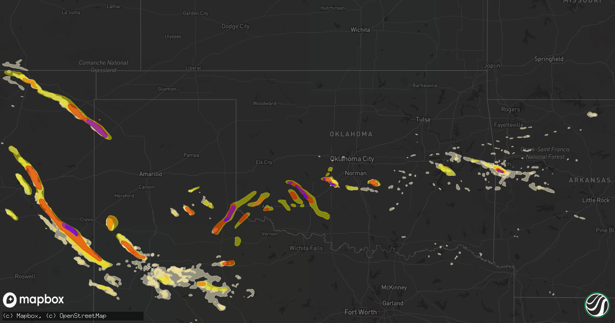
Hail Map in Oklahoma on June 30, 2017
Get this storm
June 30 map
$229
one time, instant access
Download today. No call, no setup
Keep the $229
Bought the map and want the full workflow? Apply the entire $229 to a subscription within 7 days. None of it is wasted.
Every map, not just this one
This buys you this map. Subscription and you get every map we run, in the markets you choose from a few cities to whole states to nationwide. Plus real-time alerts the moment a storm fires.
Contact data
Name, contact info, occupancy, even credit band for addresses in the footprint. You go from where it hit to who to call.
Become the source they trust
Unlimited branding weather history reports on demand. You already have the documented answer ready for the property owner, and you are the one who showed up with it.
Property data and RoofTrace estimates
Pull up any address you have got, its value and the exact code rules for that jurisdiction, straight from One Click Code. Then RoofTrace estimates the squares, pitch, and roof value, priced the way you price.
Storm reports in Oklahoma
Oklahoma
| Date | Description |
|---|---|
| 06/30/20176:57 PM CDT | From kswo tv. |
| 06/30/20176:52 PM CDT | A local report indicates 59 MPH wind near LAWTON |
| 06/30/20176:33 PM CDT | From kswo tv. |
| 06/30/20176:20 PM CDT | From kswo tv. |
| 06/30/20176:18 PM CDT | A local report indicates 1.00 inch wind near TRIBBEY |
| 06/30/20176:14 PM CDT | A local report indicates 1.00 inch wind near APACHE |
| 06/30/20176:14 PM CDT | Few trees down. Several large limbs down. |
| 06/30/20176:08 PM CDT | Relayed by kokh tv. |
| 06/30/20176:01 PM CDT | A local report indicates 1.00 inch wind near MIDDLEBERG |
| 06/30/20175:35 PM CDT | A local report indicates 2.00 inch wind near 5 WSW BOONE |
| 06/30/20174:30 PM CDT | A local report indicates 1.75 inch wind near GOTEBO |
| 06/29/201711:15 PM CDT | Estimated 60-70 mph near johnson creek campgrounds. Possible microburst. No damage found as of yet. |
| 06/29/201710:58 PM CDT | A local report indicates 70 MPH wind near 1 SSW OAKLAND |
| 06/29/201710:50 PM CDT | Power lines down... Sheet metal building destroyed. Time estimated from radar. |
| 06/29/201710:40 PM CDT | A local report indicates 60 MPH wind near 4 NNW LEBANON |
| 06/29/201710:20 PM CDT | Power poles down. Semi overturned on i35 mile marker 11. |
| 06/29/201710:15 PM CDT | A local report indicates 61 MPH wind near 11 NE ARDMORE |
| 06/29/20179:28 PM CDT | Tree limbs 1 inch in diameter broken and shingles blown off roof. |
| 06/29/20178:40 PM CDT | Large tree blown down onto travel trailer at the valley inn rv park. |
| 06/29/20178:00 PM CDT | A local report indicates 1.00 inch wind near 4 SE EUFAULA |
| 06/29/20177:59 PM CDT | Multiple power poles downed. |
| 06/29/20177:55 PM CDT | Dime to quarter hail near longtown. |
| 06/29/20177:55 PM CDT | Dime to quarter hail west of longtown. Corrected for location. |
| 06/29/20177:31 PM CDT | Observed near i-40 and hwy 59. |
| 06/29/20177:29 PM CDT | Many power lines downed. |
| 06/29/20177:29 PM CDT | A local report indicates 1.00 inch wind near ALTUS |
| 06/29/20177:26 PM CDT | At city high school. |
| 06/29/20177:16 PM CDT | A local report indicates 70 MPH wind near WALTERS |
| 06/29/20177:15 PM CDT | Power pole downed. |
| 06/29/20177:05 PM CDT | A local report indicates 72 MPH wind near 3 ESE LAWTON |
| 06/29/20177:05 PM CDT | Warner pd reports trees uprooted... Numerous branches down. |
All States Impacted by Hail Map on June 30, 2017
Cities Impacted by Hail Map on June 30, 2017
- Anton, TX
- Raton, NM
- Vian, OK
- Sallisaw, OK
- Laconia, IN
- Mauckport, IN
- Battletown, KY
- Plains, TX
- Springer, NM
- Colorado City, TX
- Newkirk, NM
- Cuervo, NM
- Garita, NM
- Fort Sumner, NM
- House, NM
- Aspermont, TX
- Corona, NM
- Clarendon, TX
- Morton, TX
- Rogers, NM
- Portales, NM
- Causey, NM
- Jayton, TX
- Marine On Saint Croix, MN
- Saratoga Springs, NY
- Ballston Spa, NY
- Stillwater, NY
- North Bend, NE
- Floyd, NM
- Denver City, TX
- Tatum, NM
- Yeso, NM
- Silverton, TX
- Muleshoe, TX
- Wilson, TX
- Tahoka, TX
- Lubbock, TX
- Grenville, NM
- Belle Plaine, MN
- New Prague, MN
- Jordan, MN
- Valparaiso, NE
- Davey, NE
- Raymond, NE
- Ceresco, NE
- Blooming Prairie, MN
- Ellendale, MN
- Booneville, AR
- Charleston, AR
- Grover Hill, OH
- Justiceburg, TX
- Lakeview, TX
- Crosbyton, TX
- Farwell, TX
- Post, TX
- Terre Haute, IN
- Purcell, OK
- Decatur, IN
- Paducah, TX
- Quitaque, TX
- Mountainville, NY
- New Windsor, NY
- Cornwall On Hudson, NY
- Cornwall, NY
- Amherst, TX
- Littlefield, TX
- Shallowater, TX
- Sudan, TX
- Moriarty, NM
- Mulberry, AR
- Pisgah, IA
- Moorhead, IA
- Brunswick, GA
- Bunch, OK
- Norfork, AR
- Mountain Home, AR
- Newhope, AR
- Middletown, NY
- Sparrow Bush, NY
- Port Jervis, NY
- Huguenot, NY
- Cuddebackville, NY
- Otisville, NY
- Matamoras, PA
- Monticello, IN
- Monon, IN
- Francesville, IN
- Winamac, IN
- Darien, GA
- Townsend, GA
- Hamler, OH
- Deshler, OH
- Holgate, OH
- Wanette, OK
- Hermleigh, TX
- Idalou, TX
- Clayton, IN
- Galion, OH
- Mount Gilead, OH
- Danville, AR
- Rover, AR
- Briggsville, AR
- Haskell, TX
- Stamford, TX
- Rule, TX
- Paris, AR
- Snyder, TX
- Girard, TX
- Lexington, OK
- Asher, OK
- Macomb, OK
- Chickasha, OK
- Lorenzo, TX
- Slaton, TX
- Yemassee, SC
- Early Branch, SC
- Buena Vista, NM
- Cleveland, NM
- Ocate, NM
- Mora, NM
- Ralls, TX
- Elida, NM
- Clayton, NM
- Sedan, NM
- Dalhart, TX
- Amistad, NM
- Greenwood, AR
- Fort Wayne, IN
- Columbia City, IN
- Roanoke, IN
- Scandia, MN
- Gloversville, NY
- Pine Village, IN
- Otterbein, IN
- Friona, TX
- Fayetteville, AR
- Elkins, AR
- Byars, OK
- Crane, TX
- Allen, OK
- Witter, AR
- Combs, AR
- Saint Paul, AR
- Traskwood, AR
- Benton, AR
- Huntington, IN
- Stonewall, OK
- Braggs, OK
- Muskogee, OK
- Spur, TX
- Mooresville, IN
- Taiban, NM
- Pep, NM
- Whiteface, TX
- Conchas Dam, NM
- Subiaco, AR
- Scranton, AR
- Ozark, AR
- Dover, FL
- Verden, OK
- Muldrow, OK
- Wabash, IN
- Emerson, AR
- Magnolia, AR
- Ropesville, TX
- Havana, AR
- McCaulley, TX
- Hamlin, TX
- Rotan, TX
- Roby, TX
- Konawa, OK
- Hope, MN
- Owatonna, MN
- Capitan, NM
- Waterville, MN
- Red Oak, OK
- Wister, OK
- Fort Smith, AR
- Haviland, OH
- Paulding, OH
- Milnesand, NM
- Harrisburg, PA
- Altheimer, AR
- Williamsport, IN
- Hector, MN
- Cee Vee, TX
- Amber, OK
- Blanchard, OK
- Wetumka, OK
- Wewoka, OK
- Holdenville, OK
- Henryetta, OK
- Council Hill, OK
- Rudy, AR
- Alma, AR
- Mountainburg, AR
- Wilburton, OK
- Spiro, OK
- Gans, OK
- Arkoma, OK
- Pocola, OK
- Ransom Canyon, TX
- Attica, IN
- Marshall, AR
- Des Moines, NM
- Midkiff, TX
- Brownfield, TX
- Warner, OK
- Vaughn, NM
- Waterloo, NE
- Springfield, NE
- Gretna, NE
- Yutan, NE
- Ashland, NE
- Weston, CO
- Meadow, TX
- Tokio, TX
- Winslow, AR
- Trementina, NM
- Old Glory, TX
- Hector, AR
- Vendor, AR
- Jasper, AR
- Carrizozo, NM
- Lindsay, OK
- Wayne, OK
- Maysville, OK
- Memphis, TX
- Van Buren, AR
- Roland, OK
- Bokoshe, OK
- New Blaine, AR
- Delaware, AR
- Levelland, TX
- Stilwell, OK
- Deer, AR
- Ponca, AR
- Trinidad, CO
- Abernathy, TX
- West Lebanon, IN
- Hot Springs National Park, AR
- Okemah, OK
- New Haven, IN
- Woodburn, IN
- Clarksville, AR
- Milford, IL
- Hedley, TX
- Huntsville, AR
- Payne, OH
- Somerville, TN
- Plainview, AR
- Bluffton, AR
- Pineland, SC
- Edison, OH
- Mansfield, OH
- Palatka, FL
- Maxwell, NM
- Stigler, OK
- Checotah, OK
- Detroit, TX
- Montezuma, NM
- Las Vegas, NM
- Yukon, OK
- Oklahoma City, OK
- Eufaula, OK
- Kinta, OK
- Quinton, OK
- Bagwell, TX
- Wesley, AR
- Odonnell, TX
- Varnville, SC
- Lebanon, IN
- Galway, NY
- Middle Grove, NY
- Tillman, SC
- Roff, OK
- Oral, SD
- Weston, NE
- Grant, OK
- Bluffton, IN
- Morse Bluff, NE
- Woodbine, IA
- Logan, IA
- Earth, TX
- Oktaha, OK
- Webbers Falls, OK
- Porum, OK
- Green Cove Springs, FL
- O'Brien, TX
- Knox City, TX
- Calvin, OK
- Columbus Grove, OH
- Plant City, FL
- Cleveland, AR
- Austin, MN
- Santa Rosa, NM
- Union City, OK
- Grantsburg, WI
- Hinckley, MN
- Fort McCoy, FL
- Malvern, AR
- Blossom, TX
- Heavener, OK
- Poteau, OK
- Howe, OK
- Waldron, AR
- Hartford, AR
- Peru, IN
- Kathleen, FL
- Lakeland, FL
- McClure, OH
- Idabel, OK
- Haworth, OK
- Brandon, FL
- Valrico, FL
- Wolfforth, TX
- Caddo, OK
- Durant, OK
- Dade City, FL
- Corydon, IN
- Lelia Lake, TX
- Seminole, OK
- Milford, PA
- Layton, NJ
- Calumet, OK
- Boncarbo, CO
- Saint Joe, AR
- Mcalester, OK
- Waverly, GA
- Barling, AR
- Huntington, AR
- Hackett, AR
- Branch, AR
- Mansfield, AR
- Magazine, AR
- Cameron, OK
- Dardanelle, AR
- Natchitoches, LA
- Ratcliff, AR
- Lithia, FL
- Beresford, SD
- Sapello, NM
- Foreston, MN
- Milaca, MN
- Carmel, NY
- Mahopac, NY
- Atwood, OK
- Childress, TX
- Springfield, GA
- Beggs, OK
- Prairie Grove, AR
- Canehill, AR
- West Fork, AR
- Hanna, OK
- Honey Grove, TX
- Sumner, TX
- Hammond, WI
- Somerset, WI
- Keota, OK
- Lavaca, AR
- Anadarko, OK
- Alex, OK
- Ninnekah, OK
- Sasakwa, OK
- Shady Point, OK
- Lafayette, IN
- Ridgeland, SC
- Rexford, NY
- Schenectady, NY
- Bowling Green, OH
- Weston, OH
- Ira, TX
- West Point, KY
- Chester, AR
- Natural Dam, AR
- Dierks, AR
- Craigville, IN
- Memphis, TN
- Millington, TN
- Hillsdale, MI
- Wimauma, FL
- Riverview, FL
- Kilkenny, MN
- Dickens, TX
- Myakka City, FL
- West Lafayette, IN
- Putnam Valley, NY
- Hugo, OK
- Sapulpa, OK
- Mounds, OK
- David City, NE
- Bruno, NE
- Granada, MN
- Arthur City, TX
- Boswell, OK
- Paris, TX
- Powderly, TX
- Lake City, MN
- Ola, AR
- Uniontown, AR
- Minco, OK
- Robert Lee, TX
- Vermillion, SD
- Memphis, NE
- Ithaca, NE
- Jonestown, PA
- Annville, PA
- Quanah, TX
- Eldorado, OK
- Crowell, TX
- Gould, OK
- Hollis, OK
- Mangum, OK
- Dodson, TX
- Gotebo, OK
- Walters, OK
- Apache, OK
- Comanche, OK
- Carnegie, OK
- Mountain View, OK
- Elgin, OK
- Fort Sill, OK
- Lawton, OK
- Duncan, OK
- Geronimo, OK
- Pocasset, OK
- Roosevelt, OK
- Indiahoma, OK
- Frederick, OK
- Mountain Park, OK
- Snyder, OK
- Cache, OK
- Headrick, OK
- Altus, OK
- Duke, OK
- Blair, OK
- Olustee, OK
- Lone Wolf, OK


