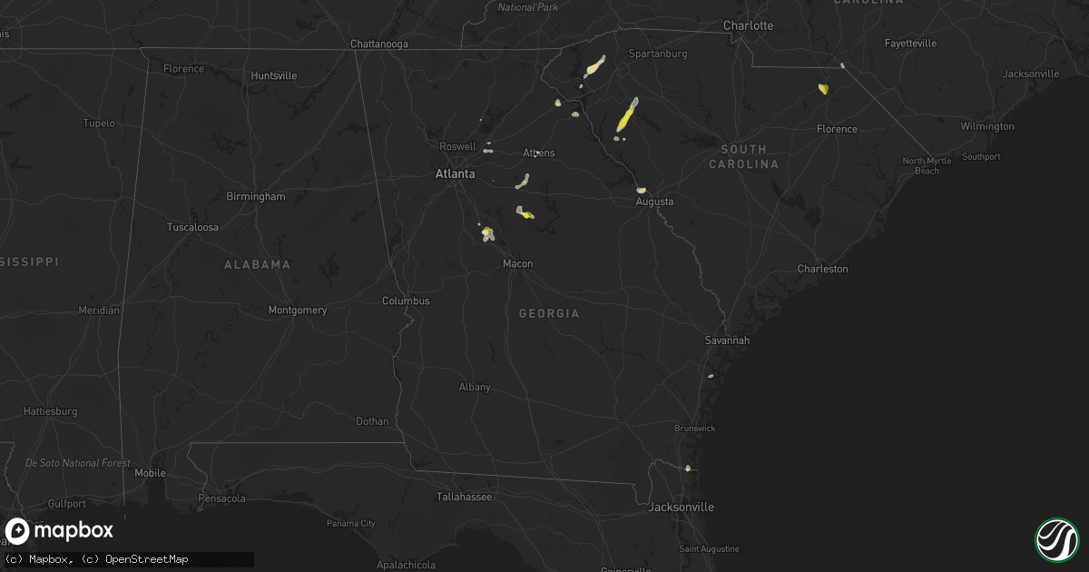
Hail Map in Georgia on June 30, 2016
Get this storm
June 30 map
$229
one time, instant access
Download today. No call, no setup
Keep the $229
Bought the map and want the full workflow? Apply the entire $229 to a subscription within 7 days. None of it is wasted.
Every map, not just this one
This buys you this map. Subscription and you get every map we run, in the markets you choose from a few cities to whole states to nationwide. Plus real-time alerts the moment a storm fires.
Contact data
Name, contact info, occupancy, even credit band for addresses in the footprint. You go from where it hit to who to call.
Become the source they trust
Unlimited branding weather history reports on demand. You already have the documented answer ready for the property owner, and you are the one who showed up with it.
Property data and RoofTrace estimates
Pull up any address you have got, its value and the exact code rules for that jurisdiction, straight from One Click Code. Then RoofTrace estimates the squares, pitch, and roof value, priced the way you price.
Storm reports in Georgia
Georgia
| Date | Description |
|---|---|
| 06/30/20165:15 PM CDT | Several 1-3 foot diameter trees snapped between baxter and sanford streets on the university of georgia campus. |
| 06/30/20164:59 PM CDT | Report of trees down along hardy-mcmanus road. |
| 06/30/20164:59 PM CDT | Report of trees down along hardy-mcmanus road. |
| 06/30/20164:30 PM CDT | Report of tree down along bar bridge road and another down on johnny fears road. |
| 06/30/20164:05 PM CDT | Dime to quarter size hail reported along high falls road near towaliga river drive. |
All States Impacted by Hail Map on June 30, 2016
Cities Impacted by Hail Map on June 30, 2016
- Blue Diamond, NV
- Eatonton, GA
- Las Vegas, NV
- Henderson, NV
- Sleepy Eye, MN
- Springfield, MN
- Morgan, MN
- Wellington, KS
- Mohave Valley, AZ
- Ware Shoals, SC
- Nashua, IA
- Plainfield, IA
- Waverly, IA
- Cedar Falls, IA
- Denver, IA
- Janesville, IA
- Waterloo, IA
- Ionia, IA
- Akron, CO
- Alden, IA
- Tulia, TX
- Happy, TX
- Queen City, MO
- Stratford, TX
- Springfield, CO
- Lamar, CO
- Anton, CO
- Tribune, KS
- Perry, OK
- Orlando, OK
- Stillwater, OK
- Squires, MO
- Rock, KS
- Sarcoxie, MO
- Highlandville, MO
- Spokane, MO
- Edwardsville, IL
- Glen Carbon, IL
- Maryville, IL
- Cut Bank, MT
- Golden Valley, AZ
- Pahrump, NV
- Ringwood, OK
- Lahoma, OK
- Helena, OK
- Meno, OK
- Groom, TX
- Kremlin, MT
- Hominy, OK
- Deepwater, MO
- Warsaw, MO
- Osceola, MO
- Lowry City, MO
- Clinton, MO
- Livermore, CO
- Tie Siding, WY
- Reeds, MO
- Rutledge, GA
- Bishop, GA
- Madison, GA
- Mansfield, GA
- Hartwell, GA
- Lebanon, MO
- Richland, MO
- Texhoma, OK
- Latham, KS
- Ault, CO
- Eaton, CO
- Willard, MO
- Halltown, MO
- Billings, MO
- Miller, MO
- Springfield, MO
- Everton, MO
- Ash Grove, MO
- Marionville, MO
- Bois D Arc, MO
- Mount Vernon, MO
- Republic, MO
- Pampa, TX
- Piedmont, OK
- Okarche, OK
- Sedan, KS
- Pawhuska, OK
- Chautauqua, KS
- Peru, KS
- Burlington, CO
- Midway, GA
- Inverness, MT
- Wayside, TX
- Hodges, SC
- Donalds, SC
- Abbeville, SC
- Death Valley, CA
- Tierra Amarilla, NM
- Micanopy, FL
- Hawthorne, FL
- Shady Dale, GA
- Monticello, GA
- Wiggins, CO
- Fort Morgan, CO
- Cumming, GA
- Sumner, MO
- Garden City, MO
- Marshall, MO
- Sweet Springs, MO
- Malta Bend, MO
- Blackburn, MO
- Laclede, MO
- Brookfield, MO
- Linneus, MO
- Triplett, MO
- Hale, MO
- Purdy, MO
- Briggsdale, CO
- Washburn, MO
- Powell, MO
- Nipton, CA
- Fort Benton, MT
- Gildford, MT
- Loma, MT
- Hingham, MT
- Big Sandy, MT
- Geraldine, MT
- Blockton, IA
- Redding, IA
- Franklin, VA
- Choteau, MT
- Marshfield, MO
- Hartville, MO
- Oakley, ID
- Grouse Creek, UT
- Lawrenceville, GA
- Fairfax, OK
- Granby, MO
- Neosho, MO
- Ketchum, ID
- Cassville, MO
- Cope, CO
- Pritchett, CO
- Iowa Falls, IA
- Hubbard, IA
- New Providence, IA
- Eldora, IA
- Beryl, UT
- Argyle, IA
- Wayland, MO
- Copan, OK
- Dewey, OK
- Ponte Vedra, FL
- Spearman, TX
- Caliente, NV
- Troy, KS
- Highland, KS
- Oregon, MO
- Canton, IL
- Claude, TX
- Laquey, MO
- Trenton, MO
- Gill, CO
- Genoa, CO
- Dacula, GA
- Eagleville, MO
- Buffalo, WY
- Seymour, MO
- Meadview, AZ
- Kingman, AZ
- Easley, SC
- Six Mile, SC
- Liberty, SC
- Central, SC
- Norris, SC
- Rogersville, MO
- Fordland, MO
- Sharon Springs, KS
- Weskan, KS
- Orchard, CO
- Kersey, CO
- Weldona, CO
- Van Buren, MO
- Mexico, MO
- Santa Fe, MO
- Fairview, MO
- Stark City, MO
- Stella, MO
- Faribault, MN
- Kanorado, KS
- Mound City, KS
- Mulhall, OK
- Limon, CO
- Hugo, CO
- Sloan, NV
- Cotter, AR
- Benton, IA
- Searchlight, NV
- Evans, GA
- Bellevue, ID
- Niangua, MO
- Keswick, IA
- Gibson, IA
- Flippin, AR
- Yellville, AR
- Lenoir, NC
- Winthrop, MN
- Ponte Vedra Beach, FL
- Saint Augustine, FL
- Alva, OK
- Waynoka, OK
- Marland, OK
- Holly, CO
- Ida Grove, IA
- Holstein, IA
- Blandinsville, IL
- Rosston, OK
- Buffalo, OK
- Laverne, OK
- Novelty, MO
- Douglass, KS
- Granada, CO
- Seneca, MO
- Fair Grove, MO
- Spickard, MO
- Princeton, MO
- Ridgeway, MO
- Goodland, KS
- Dows, IA
- West Point, IL
- Basco, IL
- Warsaw, IL
- Bowen, IL
- Viroqua, WI
- Westby, WI
- Martin, GA
- Lavonia, GA
- Sergeant Bluff, IA
- Salix, IA
- El Reno, OK
- Bethune, CO
- Needles, CA
- Courtland, VA
- Guthrie, OK
- Crescent, OK
- Cashion, OK
- Dacoma, OK
- Glenwood, MO
- Dundas, MN
- Guymon, OK
- Bethalto, IL
- Cottage Hills, IL
- Alton, IL
- East Alton, IL
- Garland, KS
- Quartzsite, AZ
- Miami, MO
- Bosworth, MO
- Carrollton, MO
- Brunswick, MO
- De Witt, MO
- Saint Marys, GA
- Cole Camp, MO
- Udall, KS
- Belle Plaine, KS
- Memphis, MO
- Webster, IA
- Farmington, IA
- Hillsboro, IA
- Donnellson, IA
- Amarillo, TX
- Weaubleau, MO
- Ponce De Leon, MO
- Crane, MO
- Clever, MO
- Nixa, MO
- Galena, MO
- Chestnutridge, MO
- Aurora, MO
- Patrick, SC
- Society Hill, SC
- Cheraw, SC
- Pender, NE
- Thurston, NE
- Wakefield, NE
- Easton, KS
- Leavenworth, KS
- McLouth, KS
- Lakefield, MN
- Meriden, KS
- Rudyard, MT
- Hatfield, MO
- Olathe, KS
- Medford, MN
- Anderson, MO
- Jackson, GA
- Forsyth, GA
- Barnesville, GA
- Stratton, CO
- Walnut Grove, MO
- Pleasant Hope, MO
- Eldridge, MO
- Thornfield, MO
- Panhandle, TX
- Winfield, KS
- Winter Park, FL
- Maitland, FL
- Boise City, OK
- Malta, ID
- Livonia, MO
- Albany, MO
- Denver, MO
- Orchard, IA
- Elma, IA
- Riceville, IA
- Webb City, MO
- Joplin, MO
- Carterville, MO
- Raeford, NC
- Montello, NV
- Enterprise, UT
- Grant City, MO
- Bedford, IA
- Clearfield, IA
- Mount Ayr, IA
- Quimby, IA
- Ivor, VA
- Wakefield, VA
- Sedley, VA
- Mountain Home, AR
- Atlanta, KS
- Babb, MT
- Martinsville, MO
- Brighton, MO
- Doniphan, MO
- Gray Court, SC
- Laurens, SC
- Idaho Falls, ID
- Marshall, NC
- Bonaparte, IA
- Greenfield, MO
- Amargosa Valley, NV
- Indian Lake Estates, FL
- Yukon, OK
- Clarendon, TX
- Howard, KS
- Urich, MO
- Clarks Hill, SC
- Augusta, GA
- Pierce City, MO
- Monett, MO
- Granite Canon, WY
- Carthage, MO
- Edwards, MO
- Joplin, MT
- Pleasant Hill, MO
- Burbank, OK
- Cedar Vale, KS
- Rapid River, MI
- Meadville, MO
- Ralston, OK
- New Hampton, MO
- Bennettsville, SC
- Hamlet, NC
- Seneca, SC
- Chatham, MI
- Trenary, MI
- Ponca City, OK
- Jean, NV
- Clemons, IA
- Marshalltown, IA
- State Center, IA
- Baker, CA
- Bruner, MO
- Sparta, MO
- Milan, MO
- Sand Coulee, MT
- Fairfield, MT
- Cuba, IL
- Morrisville, MO
- Clinton, NC
- Newton Grove, NC
- Carl Junction, MO
- Keokuk, IA
- Chillicothe, MO
- Craig, MO
- Waverly, MO
- Rogers, AR
- Hamilton, IL
- Houstonia, MO
- Hindsville, AR
- Huntsville, AR
- Ashland, KS
- Windsor, MO
- Lincoln, MO
- Rocky Comfort, MO
- Clemson, SC
- Granite City, IL
- Collinsville, IL
- Homer, NE
- Sloan, IA
- Lucerne, MO
- Reeds Spring, MO
- Mountain Grove, MO
- Gilliam, MO
- Slater, MO
- Jackpot, NV
- May, OK
- Littlefield, AZ
- Macks Creek, MO
- Oak Hill, FL
- Osteen, FL
- Vona, CO
- Deep River, IA
- Taylorsville, NC
- Wasola, MO
- Noble, MO
- Gassville, AR
- Ozark, MO
- Calico Rock, AR
- Norfork, AR
- What Cheer, IA
- Camdenton, MO
- Fairfield, ID
- Ferguson, NC
- Boomer, NC
- Montrose, MO
- Freedom, OK
- Wyola, MT
- Lockwood, MO
- South Greenfield, MO
- Burden, KS
- Montrose, IA
- Tonganoxie, KS
- Athens, GA
- Nevada, IA
- Palatka, FL
- Buford, GA
- Calumet, OK
- Sigourney, IA
- North English, IA
- Leeton, MO
- Collinsville, OK
- Oxford, GA
- Exeter, MO
- Carter, MT
- Marathon, WI
- Tripoli, IA
- Arbela, MO
- Emerson, NE
- Arriba, CO
- Oronogo, MO


