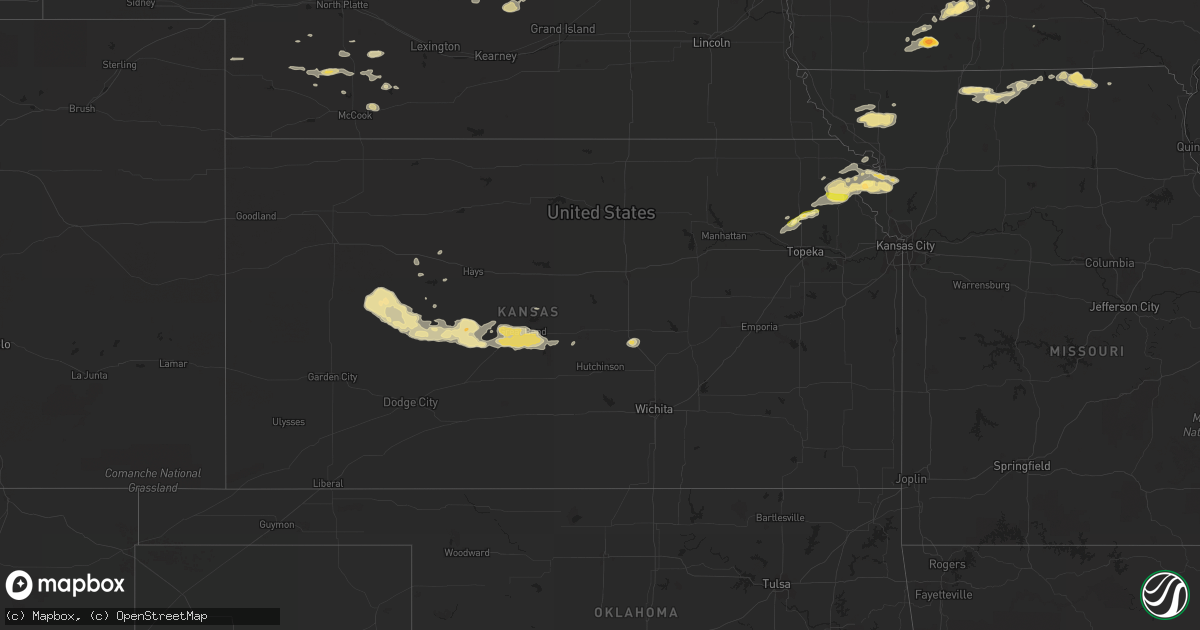
Hail Map in Kansas on June 29, 2014
Get this storm
June 29 map
$229
one time, instant access
Download today. No call, no setup
Keep the $229
Bought the map and want the full workflow? Apply the entire $229 to a subscription within 7 days. None of it is wasted.
Every map, not just this one
This buys you this map. Subscription and you get every map we run, in the markets you choose from a few cities to whole states to nationwide. Plus real-time alerts the moment a storm fires.
Contact data
Name, contact info, occupancy, even credit band for addresses in the footprint. You go from where it hit to who to call.
Become the source they trust
Unlimited branding weather history reports on demand. You already have the documented answer ready for the property owner, and you are the one who showed up with it.
Property data and RoofTrace estimates
Pull up any address you have got, its value and the exact code rules for that jurisdiction, straight from One Click Code. Then RoofTrace estimates the squares, pitch, and roof value, priced the way you price.
Storm reports in Kansas
Kansas
| Date | Description |
|---|---|
| 06/29/20146:46 PM CDT | Trained spotter estimated largest hail size of 1 inch. |
| 06/29/20148:05 AM CDT | A local report indicates 1.00 inch wind near 7 S NESS CITY |
| 06/29/20147:25 AM CDT | A few small tree limbs were down. |
| 06/28/20149:23 PM CDT | Brief tornado near lyman road |
| 06/28/20149:08 PM CDT | Reported on the ground in the town of atchison |
| 06/28/20149:05 PM CDT | Tornado reported on the ground at 1200 north 6th street. |
All States Impacted by Hail Map on June 29, 2014
Cities Impacted by Hail Map on June 29, 2014
- Bolckow, MO
- Graham, MO
- Barnard, MO
- Upson, WI
- Rushville, MO
- Murray, IA
- Marion, IA
- Agency, MO
- Olin, IA
- Anamosa, IA
- Sioux Center, IA
- Alta, IA
- Aurelia, IA
- Alton, IA
- Wausa, NE
- Mclean, NE
- Mason City, NE
- Springfield, SD
- Avon, SD
- Maurice, IA
- Orange City, IA
- Madison, NE
- Albion, NE
- Saint Edward, NE
- Cedar Rapids, NE
- Squaw Lake, MN
- Deer River, MN
- Mellen, WI
- Iron Belt, WI
- Glidden, WI
- Lindsay, NE
- Newman Grove, NE
- Humphrey, NE
- Norway, IA
- Fairfax, IA
- Watkins, IA
- Atkins, IA
- Blairstown, IA
- Van Horne, IA
- Newhall, IA
- Ness City, KS
- Logan, IA
- Missouri Valley, IA
- Modale, IA
- Randalia, IA
- Hawkeye, IA
- Sumner, IA
- Fredericksburg, IA
- Dodge, NE
- Caledonia, MS
- Mount Ayr, IA
- Tingley, IA
- Benton, IA
- Diagonal, IA
- Clearfield, IA
- Bedford, IA
- Viborg, SD
- Ord, NE
- Superior, WI
- Duluth, MN
- Dighton, KS
- Cornucopia, WI
- Bayfield, WI
- Iron River, WI
- Port Wing, WI
- Washburn, WI
- Herbster, WI
- Sargent, NE
- Burwell, NE
- Elyria, NE
- Comstock, NE
- Afton, IA
- Mayetta, KS
- Paxton, IL
- Gibson City, IL
- Melvin, IL
- Iowa Falls, IA
- Varna, IL
- Lacon, IL
- Morrison, IL
- Chadwick, IL
- Fulton, IL
- Ashton, NE
- Rockville, NE
- Farwell, NE
- Loup City, NE
- Wathena, KS
- Troy, KS
- Dunlap, IA
- Audubon, IA
- La Pointe, WI
- Orr, MN
- Galva, KS
- Moundridge, KS
- Mcpherson, KS
- Winnetoon, NE
- Orchard, NE
- Great Bend, KS
- Pawnee Rock, KS
- St John, KS
- Ionia, IA
- New Hampton, IA
- Memphis, MO
- Downing, MO
- Marcus, IA
- Clam Lake, WI
- Spencer, IA
- Harpers Ferry, IA
- Monticello, IA
- Harlan, IA
- Carroll, IA
- Glidden, IA
- Taylor, NE
- Hartley, IA
- Hawarden, IA
- Auburn, IA
- Sibley, IL
- Franklin, GA
- Guilford, MO
- Princeton, MO
- Presque Isle, WI
- Marenisco, MI
- Land O'Lakes, WI
- Hurley, WI
- Montreal, WI
- Soldier, IA
- Ute, IA
- Beresford, SD
- Arrowsmith, IL
- Downs, IL
- Le Roy, IL
- Ellsworth, IL
- Postville, IA
- Isabella, MN
- Lake Worth, FL
- West Palm Beach, FL
- Prophetstown, IL
- Magnet, NE
- Osmond, NE
- Randolph, NE
- Royal, NE
- Belden, NE
- Coleridge, NE
- Laurel, NE
- Creighton, NE
- Brunswick, NE
- Plainview, NE
- Denison, KS
- Alcester, SD
- Arcadia, FL
- Indiantown, FL
- Prairie City, IA
- Utica, KS
- Burdett, KS
- Alexander, KS
- Rush Center, KS
- Nekoma, KS
- Larned, KS
- Rozel, KS
- Beeler, KS
- Marathon, IA
- Laurens, IA
- Curlew, IA
- Webb, IA
- Schuyler, NE
- Mackinaw City, MI
- Carp Lake, MI
- Pellston, MI
- Levering, MI
- Harbor Springs, MI
- Bristow, IA
- Allison, IA
- Plainfield, IA
- Calmar, IA
- Ossian, IA
- Fort Atkinson, IA
- Waucoma, IA
- Lawler, IA
- Dumont, IA
- Greene, IA
- Nashua, IA
- Waukon, IA
- Waverly, IA
- Clarksville, IA
- Decorah, IA
- Benton, WI
- Cuba City, WI
- Newnan, GA
- Petersburg, NE
- Hayward, WI
- Cable, WI
- Lehigh, IA
- Fort Dodge, IA
- Howells, NE
- Bessemer, MI
- Ironwood, MI
- Forest City, IA
- Westside, IA
- Iron River, MI
- Watersmeet, MI
- Hayes Center, NE
- Conception Junction, MO
- Albany, IL
- Fenton, IL
- Titonka, IA
- Wesley, IA
- Stanwood, IA
- Mechanicsville, IA
- Tipton, IA
- Clarence, IA
- Lisbon, IA
- Coggon, IA
- Central City, IA
- Alburnett, IA
- Center Point, IA
- Saint Joseph, MO
- Hooper, NE
- Nickerson, NE
- Everly, IA
- Blair, NE
- Woodbine, IA
- Portsmouth, IA
- Drummond Island, MI
- De Tour Village, MI
- Mount Horeb, WI
- Cross Plains, WI
- Verona, WI
- Erie, IL
- Brooksville, FL
- Lake Nebagamon, WI
- Brule, WI
- Saxon, WI
- Gladbrook, IA
- Beaman, IA
- Grundy Center, IA
- New Providence, IA
- Hubbard, IA
- Union, IA
- Eldora, IA
- Conrad, IA
- Lowndesboro, AL
- De Kalb, MO
- Ansley, NE
- Atchison, KS
- Bendena, KS
- Aspinwall, IA
- Templeton, IA
- Dedham, IA
- Manilla, IA
- Manning, IA
- Ewing, NE
- Radcliffe, IA
- Granville, IA
- Ireton, IA
- Paullina, IA
- North Loup, NE
- Paton, IA
- Churdan, IA
- Allen, NE
- Waterbury, NE
- Emerson, NE
- Hubbard, NE
- Brimson, MN
- Schaller, IA
- Galva, IA
- Algona, IA
- Crystal Lake, IA
- Woden, IA
- Leland, IA
- Garner, IA
- Britt, IA
- Burt, IA
- Gray, GA
- Rembrandt, IA
- Sioux Rapids, IA
- Linn Grove, IA
- Ayrshire, IA
- Indianola, IA
- Dry Branch, GA
- Bartlett, NE
- Ericson, NE
- Mason City, IA
- Manly, IA
- Clear Lake, IA
- Jeffersonville, GA
- Irwinton, GA
- Danville, GA
- Dow City, IA
- Boone, IA
- Stratford, IA
- Whitesburg, GA
- Barnum, IA
- Emmetsburg, IA
- Graettinger, IA
- Middleton, WI
- Madison, WI
- Newtown, MO
- Lucerne, MO
- Chambers, NE
- Valley Falls, KS
- Maywood, NE
- Mount Auburn, IA
- Dysart, IA
- Buckingham, IA
- La Porte City, IA
- Dayton, IA
- Holland, IA
- Dike, IA
- Reinbeck, IA
- Niobrara, NE
- Tyndall, SD
- Tabor, SD
- Wagner, SD
- Storm Lake, IA
- Hanlontown, IA
- Chenoa, IL
- Colfax, IL
- Lexington, IL
- Lytton, IA
- Lake City, IA
- Remsen, IA
- Gowrie, IA
- Otho, IA
- Callender, IA
- Harcourt, IA
- Sycamore, IL
- Thayer, IA
- Peru, IA
- Lorimor, IA
- Wakefield, MI
- Laurel, IA
- Lake View, IA
- Sac City, IA
- Jolley, IA
- Rockwell City, IA
- Ravenna, NE
- Hazard, NE
- Mchenry, IL
- Wauconda, IL
- Blairsburg, IA
- Lohrville, IA
- Burnside, IA
- Kamrar, IA
- Ellsworth, IA
- Alden, IA
- Webster City, IA
- Jewell, IA
- Duncombe, IA
- Pilot Mound, IA
- Stanhope, IA
- Farnhamville, IA
- Williams, IA
- Temple, GA
- Buchanan, GA
- Bremen, GA
- Irene, SD
- Darlington, WI
- Gratiot, WI
- South Wayne, WI
- Indianola, NE
- Bunnell, FL
- Kirkman, IA
- Herman, NE
- Persia, IA
- Elk Horn, IA
- Panama, IA
- Kimballton, IA
- Magnolia, IA
- Wakeeney, KS
- Truro, IA
- Osceola, IA
- Lidderdale, IA
- Breda, IA
- Cainsville, MO
- Ridgeway, MO
- Ogden, IA
- Nortonville, KS
- Cummings, KS
- Effingham, KS
- Lancaster, KS
- Elgin, IA
- Humboldt, IA
- Carrollton, GA
- Mercer, WI
- Coon Rapids, IA
- Moorefield, NE
- Quinter, KS
- McIntyre, GA
- Gordon, GA
- Coal Valley, IL
- Wallace, NE
- Martelle, IA
- Truesdale, IA
- Center Junction, IA
- Hartington, NE
- Newcastle, NE
- Yankton, SD
- Spalding, NE
- Elliott, IL
- Loda, IL
- Cropsey, IL
- Strawn, IL
- Anchor, IL
- Ludlow, IL
- Fairbury, IL
- Cleghorn, IA
- Meriden, IA
- Vinton, IA
- Fonda, IA
- Oregon, WI
- Mcfarland, WI
- Two Harbors, MN
- Stoughton, WI
- Moran, MI
- Lenox, IA
- Barnum, MN
- Kettle River, MN
- Dana, IA
- Everest, KS
- Faucett, MO
- Dearborn, MO
- Woodman, WI
- Wauzeka, WI
- West Bend, IA
- Wenona, IL
- Lostant, IL
- Magnolia, IL
- McNabb, IL
- Streator, IL
- Rock City, IL
- Ridott, IL
- Dakota, IL
- Purdum, NE
- Brewster, NE
- Lehigh Acres, FL
- Fort Myers, FL
- Little Sioux, IA
- Pisgah, IA
- Gower, MO
- Maquoketa, IA
- Early, IA
- Scranton, IA
- Odebolt, IA
- Milo, IA
- Ackworth, IA
- Page, NE
- Inman, NE
- Oneill, NE
- Baraboo, WI
- North Freedom, WI
- Waterloo, IA
- Waynesville, IL
- Wellman, IA
- Okeechobee, FL
- Fort Pierce, FL
- Naples, FL
- Clarkson, NE
- Leigh, NE
- Holton, KS
- Creston, NE
- Scotia, NE
- Wolbach, NE
- Greeley, NE
- Livonia, MO
- Unionville, MO
- Coatsville, MO
- Glenwood, MO
- Queen City, MO
- Lancaster, MO
- Saint Paul, NE
- Lena, IL
- Winslow, IL
- Genoa, NE
- Branch, MI
- Milledgeville, GA
- Lyons, KS
- Sterling, KS
- Kensett, IA
- Nora Springs, IA
- Fayette, IA
- Castalia, IA
- Bradford, IA
- Ackley, IA
- Geneva, IA
- Hampton, IA
- Muscotah, KS
- Horton, KS
- Denton, KS
- Boscobel, WI
- Shellsburg, IA
- Mallard, IA
- Rolfe, IA
- Cedar Rapids, IA
- Cylinder, IA
- Cottage Grove, WI
- Fennimore, WI
- Woodhull, IL
- Story City, IA
- Autaugaville, AL
- Finland, MN
- Maple Park, IL
- Crystal Lake, IL
- Island Lake, IL
- Prairie Du Chien, WI
- Lowden, IA
- Wellfleet, NE
- Preston, IA
- Bryant, IA
- Charlotte, IA
- Miles, IA
- North English, IA
- Nemaha, IA
- Albert City, IA
- Cherokee, IA
- Claflin, KS
- Ransom, KS
- Browntown, WI
- Stockton, IL
- Warren, IL
- Apple River, IL
- Shullsburg, WI
- Scales Mound, IL
- Palm City, FL
- Lake Mills, WI
- Waterloo, WI
- Argyle, WI
- Westville, FL
- Hudson, KS
- Albert, KS
- Ellinwood, KS
- Springville, IA
- Mohawk, MI
- Belgrade, NE
- Denison, IA
- Charter Oak, IA
- Schleswig, IA
- Cochran, GA
- Chester, GA
- Hancock, MI
- Wauneta, NE
- Highland, WI
- Hudson, IA
- Peosta, IA
- Epworth, IA
- Hudson, SD
- Le Mars, IA
- Chatsworth, IA
- Akron, IA
- Rock Valley, IA
- Centerville, SD
- Port Byron, IL
- Cordova, IL
- Zwingle, IA
- Skidmore, MO
- Tekamah, NE
- Maryville, MO
- Maitland, MO
- McConnell, IL
- Orangeville, IL
- Freeport, IL
- Fenton, IA
- Ruthven, IA
- Lone Rock, IA
- Aplington, IA
- Onslow, IA
- Mount Vernon, IA
- Wyoming, IA
- Holstein, IA
- Runnells, IA
- Ames, NE
- North Bend, NE
- Fremont, NE
- Scribner, NE
- Rowley, IA
- Silver Creek, NE
- Lynn Center, IL
- Gove, KS
- Poplar Grove, IL
- Belvidere, IL
- Caledonia, IL
- Rudd, IA
- Rock Falls, IA
- Fertile, IA
- Solon, IA
- Livermore, IA
- Hillsdale, IL
- Charles City, IA
- Rockford, IL
- Lyndon, IL
- Tampico, IL
- Webster, IA
- Macon, GA
- Mission Hill, SD
- Rogers, NE
- Dickens, IA
- Hopkinton, IA
- Garrison, IA
- Traer, IA
- Shannon City, IA
- Healy, KS
- Bazine, KS
- Raymond, KS
- Otis, KS
- Princeton, IA
- Camanche, IA
- De Witt, IA
- McCausland, IA
- Long Grove, IA
- Eldridge, IA
- Davenport, IA
- Grand Mound, IA
- Curtis, NE
- Irwin, IA
- Defiance, IA
- Albert Lea, MN
- Mondamin, IA
- Fullerton, NE
- Bloomington, IL
- Ely, MN
- New Virginia, IA
- Arena, WI
- Dodgeville, WI
- Avoca, WI
- Spring Green, WI
- Barneveld, WI
- Winston, GA
- Douglasville, GA
- Lawton, IA
- Moville, IA
- Delmar, IA
- Phyllis, KY
- Creston, IA
- Eustis, NE
- Monmouth, IA
- Baldwin, IA
- Parkersburg, IA
- Russell, IA
- Steamboat Rock, IA
- Wellsburg, IA
- Cooksville, IL
- McCallsburg, IA
- Amelia, NE
- Sterling, IL
- Moorhead, IA
- Onawa, IA
- Venango, NE
- Champion, NE
- Ryan, IA
- Rock Springs, WI
- Westphalia, IA
- Blencoe, IA
- Exira, IA
- Hamlin, IA
- Craig, NE
- Arlington, NE
- Earling, IA
- Arcadia, NE
- Rea, MO
- Millport, AL
- Hoyt, KS
- Rossville, KS
- Delia, KS
- Maxwell, NE
- Farnam, NE
- Stockville, NE
- Greenville, IA
- Moorland, IA
- Ellis, KS
- Monroe, IA
- Swan, IA
- Hartford, IA
- Pleasantville, IA
- Anselmo, NE
- Columbus, NE
- Muscoda, WI
- Palmer, NE
- Juliette, GA
- Saybrook, IL
- Luzerne, IA
- Belle Plaine, IA
- Boulder Junction, WI
- Cascade, IA
- Garden Prairie, IL
- Marengo, IL
- Harvard, IL
- Homer, NE
- Powersville, MO
- Pollock, MO
- Harris, MO
- Loves Park, IL
- Machesney Park, IL
- Blue River, WI
- Sabula, IA
- Normal, IL
- Dubuque, IA
- Fort Payne, AL
- Ely, IA
- Tilden, NE
- Forsyth, GA
- Armuchee, GA
- Summerville, GA
- Belleville, WI
- Rockton, IL
- Durand, IL
- Davis, IL
- Henry, IL
- Putnam, IL
- Calamus, IA
- Dixon, IA
- Pomeroy, IA
- Brownell, KS
- Geneseo, IL
- Osco, IL
- Atlantic Mine, MI
- Neponset, IL
- Buda, IL
- New Liberty, IA
- Rockford, IA
- Joice, IA
- Plymouth, IA


