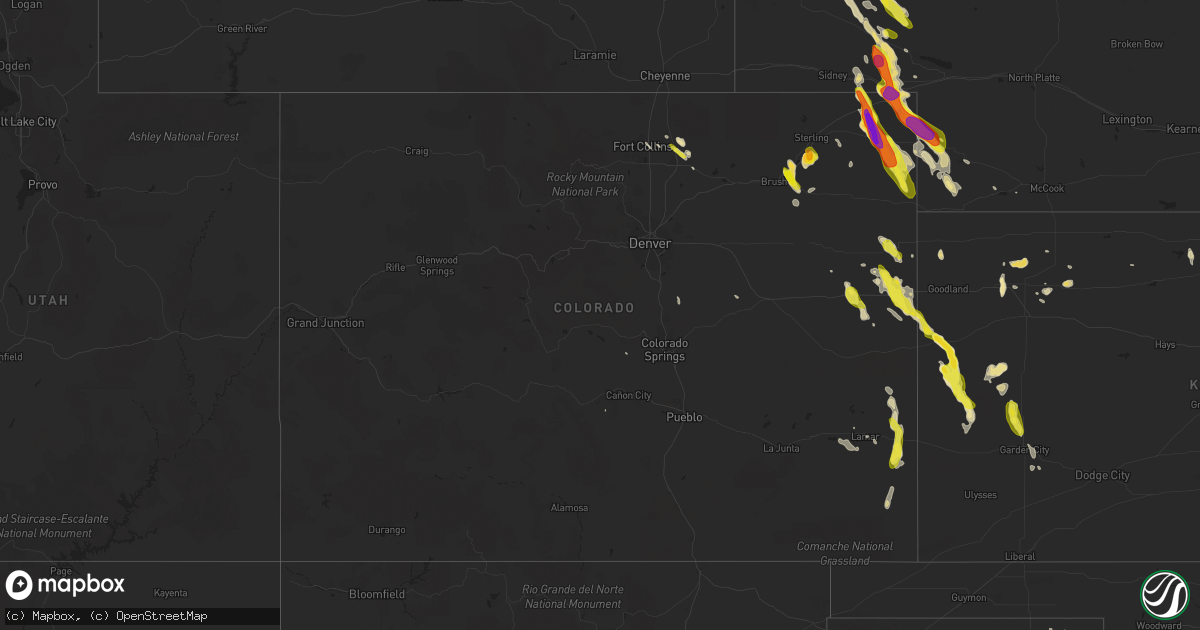
Hail Map in Colorado on June 27, 2016
Get this storm
June 27 map
$229
one time, instant access
Download today. No call, no setup
Keep the $229
Bought the map and want the full workflow? Apply the entire $229 to a subscription within 7 days. None of it is wasted.
Every map, not just this one
This buys you this map. Subscription and you get every map we run, in the markets you choose from a few cities to whole states to nationwide. Plus real-time alerts the moment a storm fires.
Contact data
Name, contact info, occupancy, even credit band for addresses in the footprint. You go from where it hit to who to call.
Become the source they trust
Unlimited branding weather history reports on demand. You already have the documented answer ready for the property owner, and you are the one who showed up with it.
Property data and RoofTrace estimates
Pull up any address you have got, its value and the exact code rules for that jurisdiction, straight from One Click Code. Then RoofTrace estimates the squares, pitch, and roof value, priced the way you price.
Storm reports in Colorado
Colorado
| Date | Description |
|---|---|
| 06/27/20166:47 PM CDT | Broken windows |
| 06/27/20166:45 PM CDT | A local report indicates 2.50 inch wind near PAOLI |
| 06/27/20166:30 PM CDT | Brief weak touchdown |
| 06/27/20166:26 PM CDT | A local report indicates 2.75 inch wind near 2 WSW PAOLI |
| 06/27/20166:14 PM CDT | A local report indicates 1.00 inch wind near 1 E AMHERST |
| 06/27/20166:05 PM CDT | Strong wind |
| 06/27/20166:03 PM CDT | A local report indicates 2.75 inch wind near 3 WNW FAIRFIELD |
| 06/27/20165:46 PM CDT | A local report indicates 1.50 inch wind near 6 SSE JULESBURG |
| 06/27/20165:40 PM CDT | Brief tornado in open rangeland |
| 06/27/20165:14 PM CDT | A local report indicates 1.75 inch wind near 4 ESE MERINO |
| 06/27/20165:01 PM CDT | Very strong winds |
| 06/27/20165:00 PM CDT | A local report indicates 1.75 inch wind near JULESBURG |
| 06/27/20164:30 PM CDT | Hail dented truck while driving on interstate 76 |
| 06/27/20163:51 PM CDT | Landspout that lasted two minutes. |
| 06/27/20162:40 PM CDT | Semi blown over near burlington and two car accident west of burlington on highway 24. |
| 06/27/20162:40 PM CDT | Estimated 60-70 mph winds with blowing dust |
| 06/27/20162:37 PM CDT | A local report indicates 66 MPH wind near 4 S BURLINGTON |
| 06/27/20162:10 PM CDT | Quarter size hail started around 110pm mdt and is still occurring as of 135pm mdt. |
| 06/26/20168:43 PM CDT | A local report indicates 1.00 inch wind near EATON |
| 06/26/20168:13 PM CDT | . |
All States Impacted by Hail Map on June 27, 2016
Cities Impacted by Hail Map on June 27, 2016
- Angora, NE
- Haxtun, CO
- Holly, CO
- Colby, KS
- Atwood, KS
- Humboldt, NE
- Auburn, NE
- Marsland, NE
- Union Grove, AL
- Oral, SD
- Hot Springs, SD
- Buffalo Gap, SD
- Cameron, LA
- Steele, MO
- New Waverly, TX
- Thomas, OK
- Caruthersville, MO
- Finley, TN
- Wiley, CO
- Wamego, KS
- Holcomb, KS
- Garden City, KS
- Boyce, LA
- Fairburn, SD
- Singer, LA
- Moscow, TN
- Rossville, TN
- Hasty, CO
- Custer, SD
- Oshkosh, NE
- Lewellen, NE
- Ellsworth, NE
- Courtland, KS
- Norway, KS
- Saint Gabriel, LA
- Carville, LA
- Sharon Springs, KS
- Baton Rouge, LA
- Yuma, CO
- Otis, CO
- Sedgwick, CO
- Wray, CO
- Lodgepole, NE
- Crook, CO
- Holyoke, CO
- Paoli, CO
- Mankato, KS
- Guide Rock, NE
- Burr Oak, KS
- Rulo, NE
- Perryton, TX
- Chadron, NE
- Clay Center, KS
- Evergreen, AL
- Elizabeth, CO
- Elbert, CO
- Franktown, CO
- Sandy Hook, MS
- Eaton, CO
- Greeley, CO
- Amity, MO
- Inavale, NE
- Forest Hill, LA
- Woodworth, LA
- Elmer, LA
- Morganville, KS
- Vona, CO
- Seibert, CO
- Sidney, IA
- Hamburg, IA
- Indian Mound, TN
- Pittsburg, TX
- Mount Pleasant, TX
- Broadwater, NE
- Frisco City, AL
- Repton, AL
- Rock Port, MO
- Oakland, IA
- Carson, IA
- Chappell, NE
- Trenton, NE
- Winona, KS
- Leoti, KS
- Scott City, KS
- Vanleer, TN
- Cumberland Furnace, TN
- Granada, CO
- Sheridan Lake, CO
- Seiling, OK
- Taloga, OK
- Oakwood, OK
- Wetmore, KS
- Netawaka, KS
- Savannah, MO
- Clarksdale, MO
- Cosby, MO
- Saint Joseph, MO
- Hemingford, NE
- Oelrichs, SD
- Hay Springs, NE
- Alliance, NE
- Smithwick, SD
- Crawford, NE
- Whitney, NE
- White City, KS
- Delight, AR
- Saint Francis, KS
- Idalia, CO
- Lance Creek, WY
- Canadian, TX
- Falls City, NE
- Craig, MO
- Lebanon, KS
- Smith Center, KS
- Gaylord, KS
- Raleigh, MS
- Alva, OK
- Apple Springs, TX
- Bogue Chitto, MS
- Durham, KS
- Tampa, KS
- Dover, TN
- Cumberland City, TN
- Peru, NE
- Nebraska City, NE
- Brownville, NE
- Geismar, LA
- Prairieville, LA
- Gonzales, LA
- Watson, MO
- Nemaha, NE
- Angie, LA
- Tylertown, MS
- Franklinton, LA
- Cedar, KS
- Miami, TX
- Portis, KS
- Osborne, KS
- Lena, MS
- Morton, MS
- Forest, MS
- Duncan, OK
- Rockwood, TN
- Florissant, CO
- Atlanta, TX
- Bivins, TX
- Castleberry, AL
- Belleville, KS
- Munden, KS
- Lakin, KS
- Wallace, KS
- Tribune, KS
- Weskan, KS
- Julesburg, CO
- Riverton, NE
- Higgins, TX
- Benkelman, NE
- Parks, NE
- Stratton, CO
- Ovid, CO
- Hillsboro, KS
- Onaga, KS
- Shannon, MS
- Nettleton, MS
- Plaquemine, LA
- Atwood, CO
- Sterling, CO
- Merino, CO
- Akron, CO
- Corrigan, TX
- Marion, AR
- Glasco, KS
- Concordia, KS
- Enders, NE
- Kirk, CO
- Hillrose, CO
- Saint James, LA
- Willis, TX
- Leedey, OK
- Mason, TN
- Oakland, TN
- Somerville, TN
- Stanton, TN
- Arlington, TN
- Burlington, CO
- Bethune, CO
- Champion, NE
- Jamestown, KS
- Natchez, MS
- Murray, KY
- Brooksville, MS
- Gypsum, KS
- Houma, LA
- Hastings, IA
- Henderson, IA
- Macedonia, IA
- Silver City, IA
- Treynor, IA
- Malvern, IA
- Piedmont, AL
- Manhattan, KS
- Riley, KS
- Bragg City, MO
- Hayti, MO
- Bridgeport, NE
- Amherst, CO
- Big Springs, NE
- Venango, NE
- Imperial, NE
- Lisco, NE
- Hendrix, OK
- Savoy, TX
- Denison, TX
- Bells, TX
- Omaha, TX
- Elm Grove, LA
- Shreveport, LA
- Haughton, LA
- Bossier City, LA
- Barksdale Afb, LA
- Linden, AL
- Monterey, TN
- Hoxie, KS
- Little Rock, AR
- Diboll, TX
- Silas, AL
- Jennings, LA
- Lake Arthur, LA
- Red Cloud, NE
- Frederick, OK
- Hermitage, AR
- Wilmar, AR
- Crowley, LA
- Egan, LA
- Morse, LA
- Hamptonville, NC
- Springhill, LA
- Denham Springs, LA
- Carmen, OK
- Marietta, TX
- Simms, TX
- Linden, TN
- Hohenwald, TN
- Cordova, TN
- Memphis, TN
- Isabella, OK
- Okeene, OK
- Pollok, TX
- Haynesville, LA
- Jacksonville, AL
- Beaver, OK
- Balko, OK
- Huntsville, TX
- Smithdale, MS
- Meadville, MS
- Benton, LA
- Crossville, TN
- Houston, MS
- Ames, OK
- Ringwood, OK
- Clyde, KS
- Marysville, KS
- Shattuck, OK
- Madison, MS
- Ault, CO
- Powhattan, KS
- Whiting, KS
- Custer City, OK
- Donaldsonville, LA
- Darrow, LA
- Madill, OK
- Goltry, OK
- Oberlin, KS
- Pawnee City, NE
- Mayetta, KS
- Holton, KS
- Mineola, IA
- Glenwood, IA
- Emerson, IA
- Imogene, IA
- Council Bluffs, IA
- Enid, OK
- Selden, KS
- White House, TN
- Table Rock, NE
- Pelahatchie, MS
- Brandon, MS
- Canton, MS
- Flowood, MS
- Warren, TX
- Agenda, KS
- Red Level, AL
- Hornbeck, LA
- Cotopaxi, CO
- Vernon, CO
- Fort Collins, CO
- Windsor, CO
- Gueydan, LA
- Amite, LA
- Loranger, LA
- Pine Ridge, SD
- Kentwood, LA
- Roseland, LA
- Waukomis, OK
- Fluker, LA
- McEwen, TN
- Cuba, KS
- Kaplan, LA
- Hendersonville, TN
- Goodlettsville, TN
- Delphos, KS
- Aurora, KS
- Miltonvale, KS
- Maple Hill, KS
- Woodland, MS
- West Liberty, KY
- Fairview, OK
- Gill, CO
- Bogue, KS
- Kersey, CO
- Clifton, KS
- Sardis, TN
- Scotts Hill, TN
- Kenansville, FL
- Johnson, NE
- Purvis, MS
- Lumberton, MS
- Sunshine, LA
- Groveton, TX
- Bladen, NE
- Roseland, NE
- Ayr, NE
- Pierce, CO
- Decaturville, TN
- Cullman, AL
- Eva, AL
- Baileyton, AL
- Jamestown, TN
- Michie, TN
- Counce, TN
- Arapaho, OK
- Fay, OK
- Putnam, OK
- Morris Chapel, TN
- Adamsville, TN
- Enville, TN
- Pacific Junction, IA
- Arlington, AL
- Pineville, LA
- Fleming, CO
- Two Buttes, CO
- Church Hill, TN
- Grand Chenier, LA
- Creole, LA
- Booker, TX
- Harrison, NE
- Lusk, WY
- Ramona, KS
- Marienthal, KS
- Hughes Springs, TX
- Forgan, OK
- Flagler, CO
- Turpin, OK
- Stewartsville, MO
- Maysville, MO
- Dierks, AR
- Okolona, MS
- Olney, TX
- Erin, TN
- Thurman, IA
- Alexandria, LA
- Woodville, MS
- Crosby, MS
- Oak, NE
- Cleveland, TX
- Minneapolis, KS
- Lipscomb, TX
- Simmesport, LA
- Petersburg, TN
- Shelbyville, TN
- Toomsuba, MS
- Laneville, TX
- Republic, KS
- Meno, OK
- Henderson, TN
- Jacks Creek, TN
- Saint George, KS
- Millry, AL
- Clarksdale, MS
- Lambert, MS
- Adams, TN
- Cedar Hill, TN
- Waverly, TN
- Follett, TX
- Loudon, TN
- Philadelphia, TN
- Newcastle, WY
- Henderson, TX
- Roxie, MS
- Waurika, OK
- Kingfisher, OK
- Dallas, TX
- Conroe, TX
- Campbell, NE
- Junction City, KS
- Burchard, NE
- Alton, KS
- Philadelphia, MS
- State Line, MS
- Abilene, KS
- Longford, KS
- Naples, TX
- Atmore, AL
- Brewton, AL
- Arnett, OK
- Centreville, AL
- Superior, NE
- Lawrence, NE
- Blue Hill, NE
- Webber, KS
- Formoso, KS
- Fairfax, MO
- Stella, NE
- Percival, IA
- Merryville, LA
- Bethel Springs, TN
- Schriever, LA
- Thibodaux, LA
- Donner, LA
- New Boston, TX
- Eads, TN
- Randolph, MS
- Wickes, AR
- Shelbyville, TX
- New Concord, KY
- Scandia, KS
- Monticello, AR
- Tennessee Ridge, TN
- Woodville, TX
- Pickens, MS
- Castalian Springs, TN
- Portland, TN
- Union, MS
- Grand Cane, LA
- Logansport, LA
- Lamar, CO
- Fort Worth, TX
- Kirwin, KS
- Manderson, SD
- Bethpage, TN
- Covington, TX
- Grandview, TX
- Weatherford, TX
- Rexford, KS
- Arlington, TX
- De Queen, AR
- Edgemont, SD
- Williston, TN
- Hampshire, TN
- Joaquin, TX
- Mountain Rest, SC
- Alma, KS
- Stratton, NE
- Birmingham, AL
- Solomon, KS
- Bonita Springs, FL
- Olivehill, TN
- Collinwood, TN
- Pierceville, KS
- McLain, MS
- Olla, LA
- Greenbrier, TN
- Clarkrange, TN
- Hessmer, LA
- Simla, CO
- Agate, CO
- Hooker, OK
- Daingerfield, TX
- McFarland, KS
- Paxico, KS
- Sweetwater, TN
- Goff, KS
- Spearsville, LA
- Timnath, CO
- Valdese, NC
- Kanorado, KS
- Snyder, CO


