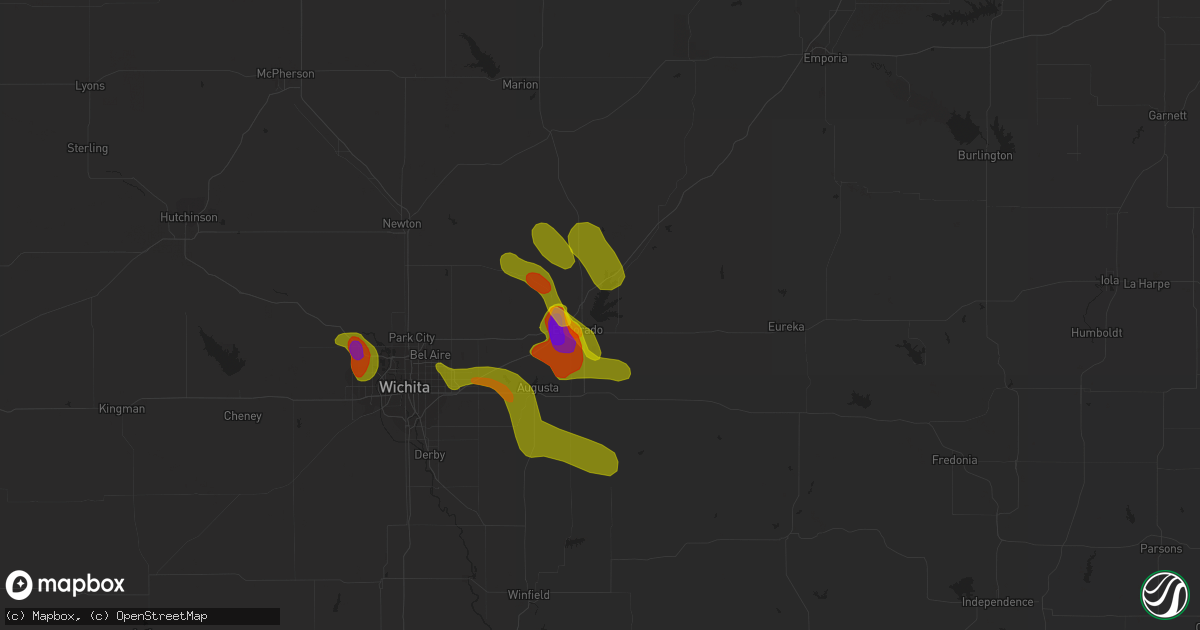
Hail Map in El Dorado, KS on June 26, 2018
Get this storm
June 26 map
$229
one time, instant access
Download today. No call, no setup
Keep the $229
Bought the map and want the full workflow? Apply the entire $229 to a subscription within 7 days. None of it is wasted.
Every map, not just this one
This buys you this map. Subscription and you get every map we run, in the markets you choose from a few cities to whole states to nationwide. Plus real-time alerts the moment a storm fires.
Contact data
Name, contact info, occupancy, even credit band for addresses in the footprint. You go from where it hit to who to call.
Become the source they trust
Unlimited branding weather history reports on demand. You already have the documented answer ready for the property owner, and you are the one who showed up with it.
Property data and RoofTrace estimates
Pull up any address you have got, its value and the exact code rules for that jurisdiction, straight from One Click Code. Then RoofTrace estimates the squares, pitch, and roof value, priced the way you price.
Storm reports in El Dorado, KS
El Dorado, KS
| Date | Description |
|---|---|
| 06/26/20186:50 PM CDT | A local report indicates 1.00 inch wind near 6 ESE POTWIN |
| 06/26/20186:39 PM CDT | Multiple reports of a brief rope tornado touchdown east of potwin and north of el dorado. |
| 06/25/20189:30 PM CDT | Quarter size hail being reported east of hwy 77 north of el dorado. |
| 06/25/20187:58 PM CDT | Butler county em reporting baseball size hail on the nw side of el dorado. |
| 06/25/20187:51 PM CDT | A local report indicates 1.75 inch wind near EL DORADO |
| 06/25/20187:50 PM CDT | Tennis ball size hail reported just west of el dorado. |
| 06/25/20187:28 PM CDT | Ping pong ball size hail reported in el dorado. |
| 06/25/20187:09 PM CDT | Weak to moderate rotation noted near spotter's location as well. |
| 06/25/20187:02 PM CDT | Butler em estimated 50 to 60 mph winds nw of el dorado. A rotating wall cloud was noted as well. |
All States Impacted by Hail Map on June 26, 2018
All Cities Impacted by Hail Map on June 26, 2018
- Tolley, ND
- Mohall, ND
- Kenmare, ND
- Killdeer, ND
- Dunn Center, ND
- Dodge, ND
- Halliday, ND
- Amidon, ND
- Scranton, ND
- Bowman, ND
- Lansford, ND
- Des Lacs, ND
- Berthold, ND
- Glenburn, ND
- Minot, ND
- Burlington, ND
- New England, ND
- South Heart, ND
- Belfield, ND
- Dickinson, ND
- Gladstone, ND
- Manning, ND
- Richardton, ND
- Taylor, ND
- Lodgepole, SD
- Reeder, ND
- Rhame, ND
- Hettinger, ND
- Hebron, ND
- Glen Ullin, ND
- Beulah, ND
- Golden Valley, ND
- Hazen, ND
- Zap, ND
- Keldron, SD
- Lemmon, SD
- Watauga, SD
- Meadow, SD
- Morristown, SD
- Lefor, ND
- New Leipzig, ND
- Elgin, ND
- Mott, ND
- Almont, ND
- Flasher, ND
- Carson, ND
- Oakman, AL
- Townley, AL
- Carbon Hill, AL
- Jasper, AL
- Ekalaka, MT
- Camp Crook, SD
- Ralph, SD
- Ludlow, SD
- Hammond, MT
- Faith, SD
- Dupree, SD
- Cherry Creek, SD
- Reva, SD
- Milesville, SD
- Buffalo, SD
- Newell, SD
- Prairie City, SD
- Midland, SD
- Mud Butte, SD
- Bison, SD
- Isabel, SD
- McIntosh, SD
- Eagle Butte, SD
- Ridgeview, SD
- White Owl, SD
- Howes, SD
- Union Center, SD
- Enning, SD
- Pierre, SD
- Lower Brule, SD
- Onida, SD
- Harrold, SD
- Holabird, SD
- Fort Thompson, SD
- Gann Valley, SD
- Highmore, SD
- Blunt, SD
- Fort Pierre, SD
- Stephan, SD
- Agar, SD
- Gettysburg, SD
- Kennebec, SD
- Chamberlain, SD
- Oacoma, SD
- Reliance, SD
- Kimball, SD
- Pukwana, SD
- Presho, SD
- Stickney, SD
- Plankinton, SD
- Parkston, SD
- Armour, SD
- Delmont, SD
- White Lake, SD
- Corsica, SD
- Vivian, SD
- Absarokee, MT
- Joliet, MT
- Columbus, MT
- Duff, TN
- La Follette, TN
- Speedwell, TN
- Whitesburg, TN
- Mohawk, TN
- Morristown, TN
- Bean Station, TN
- Mooresburg, TN
- Russellville, TN
- Powell, TN
- Ogallah, KS
- Wakeeney, KS
- Ellis, KS
- Collyer, KS
- Ness City, KS
- Bazine, KS
- Pawnee Rock, KS
- Larned, KS
- Great Bend, KS
- St John, KS
- Alexander, KS
- Liebenthal, KS
- Victoria, KS
- McCracken, KS
- La Crosse, KS
- Bison, KS
- Hays, KS
- Gorham, KS
- Albert, KS
- Otis, KS
- Macksville, KS
- Belpre, KS
- Salina, KS
- Brookville, KS
- Lenexa, KS
- Overland Park, KS
- Olathe, KS
- Paola, KS
- Osawatomie, KS
- Houstonia, MO
- Sweet Springs, MO
- Warrensburg, MO
- Centerview, MO
- Whitewater, KS
- El Dorado, KS
- Towanda, KS
- Potwin, KS
- Leon, KS
- Madison, KS
- Olpe, KS
- Atlanta, KS
- Douglass, KS
- Augusta, KS
- Rose Hill, KS
- Andover, KS
- Wichita, KS
- Halstead, KS
- Sedgwick, KS
- Fall River, KS
- Fredonia, KS
- Toronto, KS
- Cassoday, KS
- Burns, KS
- Valley Center, KS
- Maize, KS
- Colwich, KS
- Yates Center, KS
- Milton, KS
- Cheney, KS
- Clearwater, KS
- Conway Springs, KS
- Goddard, KS
- Garden Plain, KS
- Viola, KS
- Neodesha, KS
- Altoona, KS
- Farlington, KS
- Fort Scott, KS
- Hepler, KS
- Walnut, KS
- Uniontown, KS
- Argonia, KS
- Laurens, SC
- Piedmont, MO
- Mill Spring, MO
- Greenville, MO
- Fremont, MO
- Van Buren, MO
- Ellsinore, MO
- Grandin, MO
- Bantry, ND
- Deering, ND
- Upham, ND
- Towner, ND
- New Town, ND
- Rugby, ND
- Mayview, MO
- Higginsville, MO
- Harrison, SD
- Grantville, KS
- Topeka, KS
- Holden, MO
- Bates City, MO
- Freeman, MO
- Peculiar, MO
- Leslie, MO
- New Haven, MO
- Beaufort, MO
- Gerald, MO
- Richland, MO
- Henderson, KY
- Morganfield, KY
- Calhoun, KY
- Sebree, KY
- Dixon, KY
- Corydon, KY
- Robards, KY
- Owensboro, KY
- Burrton, KS
- Eureka, KS
- Lebanon, TN
- Golconda, IL
- Metropolis, IL
- Williamsburg, KY
- Indianapolis, IN
- Regent, ND
- North Salem, IN
- Jamestown, IN
- Ladoga, IN
- Lizton, IN
- New Ross, IN
- Timber Lake, SD
- Meta, MO
- Saint Thomas, MO
- Henley, MO
- Butler, MO
- Schell City, MO
- Rich Hill, MO
- Rockville, MO
- Benedict, KS
- Lowry City, MO
- Deepwater, MO
- Grand Tower, IL
- Le Roy, KS
- Neosho Falls, KS
- Dongola, IL
- Marquand, MO
- Fredericktown, MO
- Perryville, MO
- Kansas City, MO
- Lees Summit, MO
- Rutherfordton, NC
- Cadiz, KY
- Bronson, KS
- Moran, KS
- Edgar Springs, MO
- Hayes, SD
- Osceola, MO
- Clinton, MO
- Maple Park, IL
- Hampshire, IL
- Sycamore, IL
- Raymore, MO
- Belton, MO
- Pleasant Hill, MO
- Vevay, IN
- Seneca, MO
- Goodman, MO
- Neosho, MO
- Mount Hope, KS
- Andale, KS
- Rosiclare, IL
- Herod, IL
- Cave In Rock, IL
- Hampton, KY
- Salem, KY
- Elizabethtown, IL
- Smithland, KY
- Burna, KY
- Marion, KY
- Central City, KY
- Graham, KY
- Powderly, KY
- Greenville, KY
- McCormick, SC
- Mount Carmel, SC
- Calhoun Falls, SC
- Trenton, KY
- Pembroke, KY
- Thomasville, AL
- Sweet Water, AL
- Granville, ND
- Camdenton, MO
- Roach, MO
- Brumley, MO
- Montreal, MO
- Knob Noster, MO
- Fontana, KS
- Fort Leonard Wood, MO
- Stoutland, MO
- Anna, IL
- Buncombe, IL
- Murphysboro, IL
- Frohna, MO
- Pomona, IL
- Salem, MO
- Marion, NC
- Lincolnton, GA
- Marion, IL
- Creal Springs, IL
- Garden City, MO
- Harrisonville, MO
- Clay, KY
- Du Bois, IL
- Saint Mary, MO
- Sainte Genevieve, MO
- Winfield, KS
- Bumpus Mills, TN
- Edgefield, SC
- Cole Camp, MO
- Rush Center, KS
- Linn Creek, MO
- Climax Springs, MO
- Duke, MO
- Lenox, MO
- Rolla, MO
- Beulah, MO
- Newburg, MO
- Licking, MO
- Dover, TN
- Big Rock, TN
- Stonefort, IL
- Equality, IL
- Harrisburg, IL
- Carrier Mills, IL
- Eddyville, IL
- Clarksville, TN
- Castalian Springs, TN
- Gallatin, TN
- Bethpage, TN
- Peterman, AL
- Beatrice, AL
- Evergreen, AL
- Pine Apple, AL
- Ashland City, TN
- Charlotte, TN
- Moore, SC
- Talladega, AL
- Mandaree, ND
- Brownsburg, IN
- Pittsboro, IN
- Bunker Hill, KS
- Lucas, KS
- Russell, KS
- Paradise, KS
- Waldo, KS
- Walsh, IL
- Steeleville, IL
- Coulterville, IL
- Percy, IL
- Cutler, IL
- Sparta, IL
- Chester, IL
- Colony, KS
- Vienna, IL
- Albany, KY
- Hopkinsville, KY
- Williamsville, MO
- Poplar Bluff, MO
- Columbus, NC
- Osage Beach, MO
- Kaiser, MO
- Pioneer, TN
- Marble Hill, MO
- Patton, MO
- Sturgis, KY
- Logan, IL
- West Frankfort, IL
- Orient, IL
- Benton, IL
- Thompsonville, IL
- Cobden, IL
- Wolf Lake, IL
- Jonesboro, IL
- Westhope, ND
- Maxbass, ND
- Antler, ND
- Garrison, ND
- Sherwood, ND
- Oakdale, IL
- Ellis Grove, IL
- Pinckneyville, IL
- Kingsville, MO
- Green Ridge, MO
- Windsor, MO
- Altenburg, MO
- Farmington, MO
- Gorham, IL
- Farrar, MO
- Burlington, KS
- Westphalia, KS
- Odessa, MO
- Grandview, MO
- Greenwood, MO
- Lone Jack, MO
- Grain Valley, MO
- Oak Grove, MO
- Independence, MO
- Leawood, KS
- Blue Springs, MO
- Chesnee, SC
- Mooresboro, NC
- Troy, AL
- Pickens, SC
- Easley, SC
- Goreville, IL
- Luray, KS
- Concordia, MO
- Saint Robert, MO
- Haleyville, AL
- Sautee Nacoochee, GA
- Cleveland, GA
- Tompkinsville, KY
- Burkesville, KY
- Whitwell, TN
- Chattanooga, TN
- Forest City, NC
- McKenzie, AL
- Georgiana, AL
- Plevna, KS
- Glenallen, MO
- Rockholds, KY
- Jackson, MO
- Ozark, IL
- Gridley, KS
- Iola, KS
- Hermann, MO
- Owensville, MO
- Sunrise Beach, MO
- Ulman, MO
- Lake Ozark, MO
- Washington, MO
- Bremen, KY
- Madisonville, KY
- Sacramento, KY
- Macks Creek, MO
- La Cygne, KS
- Abbyville, KS
- Arlington, KS
- Turon, KS
- Sylvia, KS
- Providence, KY
- Lane, KS
- Crosby, ND
- Ambrose, ND
- Jefferson City, MO
- Zeigler, IL
- Royalton, IL
- Mulkeytown, IL
- Ewing, IL
- Ellington, MO
- Ellinwood, KS
- Claflin, KS
- Fort Payne, AL
- Tamaroa, IL
- Nashville, IL
- Ashley, IL
- Linn, MO
- Loose Creek, MO
- Walker, MO
- Mapleton, KS
- Scottsville, KY
- Springville, TN
- Buchanan, TN
- Tryon, NC
- Nashville, TN
- Mentone, AL
- Edmonton, KY
- Trenton, GA
- Eddyville, KY
- Tignall, GA
- Leeton, MO
- Padroni, CO
- Saint Johns, FL
- Barbourville, KY
- Vanleer, TN
- Maynardville, TN
- Lafayette, TN
- Pleasant Shade, TN
- Whitleyville, TN
- Red Boiling Springs, TN
- Lebanon, IN
- Cape Girardeau, MO
- Petersburg, IN
- Otwell, IN
- Winslow, IN
- Chipley, FL
- Pfeifer, KS
- Union, MO
- Alto Pass, IL
- Limon, CO
- Saint Elizabeth, MO
- Westphalia, MO
- Wappapello, MO
- Cypress, IL
- Manitou, KY
- Nebo, KY
- Caryville, TN
- Hestand, KY
- Bridgeport, AL
- Clayton, AL
- Louisville, AL
- Northport, AL
- Berry, AL
- Hayneville, AL
- Barnett, MO
- Herrin, IL
- Macedonia, IL
- McClure, IL
- Winona, MO
- Youngstown, FL
- Ramer, AL
- Lineville, AL
- Ashland, AL
- Wildwood, GA
- Lookout Mountain, GA
- Fulton, MO
- Karnak, IL
- Kevil, KY
- Grand Chain, IL
- Crane, IN
- Bedford, KY
- Prospect, KY
- Louisville, KY
- Glasgow, KY
- Dixon Springs, TN
- Ransom, KS
- Richards, MO
- Nevada, MO
- Harwood, MO
- Piqua, KS
- Richmond, KS
- Greeley, KS
- Newton, KS
- Peabody, KS
- Florence, KS
- Benton, KS
- South Pittsburg, TN
- Lafayette, AL
- Jacksonville, FL
- Cunningham, KS
- Goodwater, AL
- Veedersburg, IN
- Brownell, KS
- Tuscumbia, MO
- Eugene, MO
- Lebanon, MO
- Waynesville, MO
- Laquey, MO
- Ironton, MO
- Arcadia, MO
- Vinegar Bend, AL
- State Line, MS
- Gray Summit, MO
- Greensburg, KY
- Hollytree, AL
- Poland, IN
- Mokane, MO
- Tebbetts, MO
- Drakesboro, KY
- Glens Fork, KY
- Columbia, KY
- Abbeville, SC
- Lapine, AL
- Grady, AL
- Crocker, MO
- Dixon, MO
- Washburn, TN
- Rising Fawn, GA
- Springfield, KY
- Montgomery, AL
- Catharine, KS
- Caledonia, MO
- Vanzant, MO
- Fairview, MO
- Stark City, MO
- Stella, MO
- Granby, MO
- Wessington Springs, SD
- Fredonia, KY
- Minot Afb, ND
- Karlsruhe, ND
- Parshall, ND
- Solomon, KS
- Gypsum, KS
- Abilene, KS
- Bunceton, MO
- Prairie Home, MO
- Solsberry, IN
- Bloomfield, IN
- La Monte, MO
- Whiteman Air Force Base, MO
- Versailles, MO
- Warsaw, MO
- Villa Ridge, MO
- Boston, KY
- Oakland City, IN
- Keenes, IL
- Wayne City, IL
- De Soto, IL
- Hurst, IL
- Carbondale, IL
- Waverly, KY
- Murdock, KS
- Pretty Prairie, KS
- Bolivar, MO
- Grantsburg, IL
- West Paducah, KY
- Belknap, IL
- Centertown, KY
- Seymour, MO
- Hartville, MO
- Mansfield, MO
- Upton, KY
- Magnolia, KY
- Munfordville, KY
- Bee Spring, KY
- Mammoth Cave, KY
- Smiths Grove, KY
- Woodbine, KY
- Herndon, KY
- Clairfield, TN
- Pall Mall, TN
- Pawhuska, OK
- Bartlesville, OK
- Mount Juliet, TN
- Thorn Hill, TN
- Helenwood, TN
- Smithville, TN
- Hendersonville, TN
- Milton, TN
- Watertown, TN
- Knoxville, TN
- Oak Ridge, TN
- Valley Head, AL
- Gaffney, SC
- Atlanta, GA
- Alpharetta, GA
- Roswell, GA
- Franklin, AL
- Landrum, SC
- Mill Spring, NC
- Brevard, NC
- Walhalla, SC
- Graham, AL
- Parrish, AL
- Roseglen, ND
- Brazil, IN
- Shields, ND
- Kingdom City, MO
- Ellsworth, KS
- Louisburg, KS
- Mora, MO
- Sedalia, MO
- Hughesville, MO
- Montrose, MO
- Cedar Point, KS
- Albion, IL
- Grayville, IL
- Browns, IL
- Lincoln, MO
- Marion, KS
- Fisherville, KY
- Mauckport, IN
- Iberia, MO
- Bentley, KS
- Haven, KS
- Bardstown, KY
- La Harpe, KS
- Simpson, IL
- Ullin, IL
- Eldorado, IL
- New Burnside, IL
- Makanda, IL
- Utica, KY
- Philpot, KY
- Shawneetown, IL
- Mount Sherman, KY
- Buffalo, KY
- Elizabethtown, KY
- Glendale, KY
- Cecilia, KY
- Eastview, KY
- Brownsville, KY
- Annapolis, MO
- Knifley, KY
- Cabool, MO
- Russell Springs, KY
- Patterson, MO
- Adolphus, KY
- Westmoreland, TN
- Oakland, KY
- Gracey, KY
- Sharps Chapel, TN
- Carthage, TN
- Cumberland Furnace, TN
- Cunningham, TN
- Chapmansboro, TN
- Southside, TN
- Winfield, TN
- Spring City, TN
- Gaylesville, AL
- Menlo, GA
- Guild, TN
- West Union, SC
- Clinton, SC
- Flintstone, GA
- Greenville, SC
- Mcminnville, TN
- Tyler, AL
- Butler, AL
- Perkinston, MS
- East Palatka, FL
- Coleharbor, ND
- Capron, IL
- Poplar Grove, IL
- Lantry, SD
- Smithton, MO
- Otterville, MO
- Columbia, MO
- Westport, KY
- Newberry, IN
- Avon, IN
- New Palestine, IN
- Danville, IN
- Beech Grove, IN
- Calhoun, MO
- Charlestown, IN
- Sims, IL
- Foster, MO
- Appleton City, MO
- Hamilton, KS
- Boss, MO
- Sedan, KS
- Moline, KS
- Slaughters, KY
- Rumsey, KY
- Conway, MO
- Corbin, KY
- Lily, KY
- London, KY
- Park City, KY
- Princeton, KY
- Cave City, KY
- Horse Cave, KY
- Cerulean, KY
- Bowling Green, KY
- Alpha, KY
- Monterey, TN
- Newport, TN
- Tracy City, TN
- Madison, TN
- Hermitage, TN
- Old Hickory, TN
- Batesville, AR
- Lancaster, TN
- Columbus, MS
- Hollywood, AL
- Clover, SC
- Smyrna, SC
- York, SC
- Jackson, AL
- Saint Stephens, AL
- York, ND
- Willow City, ND
- Fort Yates, ND
- Eudora, KS
- Nelson, MO
- De Soto, KS
- Shawnee, KS
- Prairie Village, KS
- Strasburg, MO
- Napoleon, MO
- Marshall, MO
- Buckner, MO
- Gardner, KS
- Cleveland, MO
- Pilot Grove, MO
- Hartsburg, MO
- Tipton, MO
- Syracuse, MO
- Clarksburg, MO
- California, MO
- Holts Summit, MO
- Bonnots Mill, MO
- New Bloomfield, MO
- Scottsburg, IN
- Centertown, MO
- Vienna, MO
- Emporia, KS
- Strong City, KS
- Hartford, KS
- Cottonwood Falls, KS
- Eldridge, MO
- Tunas, MO
- Fort Knox, KY
- New Castle, KY
- Sulphur, KY
- Virgil, KS
- Galatia, IL
- Jacob, IL
- Uniontown, MO
- Bixby, MO
- Arkansas City, KS
- Maple City, KS
- Dexter, KS
- Campbellsville, KY
- Sonora, KY
- White Mills, KY
- Big Clifty, KY
- Hanson, KY
- Livingston, TN
- Taneyville, MO
- Bradleyville, MO
- Old Fort, NC
- Waverly, TN
- Stewart, TN
- Cookeville, TN
- Rutledge, TN
- Lowndesville, SC
- Iva, SC
- Stevenson, AL
- Sunset, SC
- Camp Hill, AL
- Dadeville, AL
- Westwego, LA
- Fitzpatrick, AL
- Kennedy, AL
- Whatley, AL
- Cragford, AL
- Reform, AL
- Burlington, IL
- Marshall, IL
- Paris, IL
- Orleans, IN
- Waverly, MO
- Malta Bend, MO
- Lexington, IN
- Bland, MO
- Morrison, MO
- Mount Sterling, MO
- Parker, KS
- La Grange, KY
- Richview, IL
- Hoyleton, IL
- Raymond, KS
- Evansville, IN
- Centerville, KS
- Carmi, IL
- Burnt Prairie, IL
- Golden Gate, IL
- Springerton, IL
- Mill Shoals, IL
- Fairfield, IL
- Barnhill, IL
- Dahlgren, IL
- McLeansboro, IL
- Buffalo, KS
- Cherryville, MO
- Oxford, KS
- Rock, KS
- Udall, KS
- Burden, KS
- Clarkson, KY
- Gray, KY
- Frakes, KY
- Bybee, TN
- Crab Orchard, TN
- Martin, GA
- Lavonia, GA
- Red Level, AL
- Lilburn, GA
- Lawrenceville, GA
- Perry, FL
- Elrod, AL
- Fayette, AL
- Livermore, KY
- Urich, MO
- Hudson, KS
- Tell City, IN
- Hazel, KY
- Mountain Rest, SC
- Dennison, IL
- Joelton, TN
- Pisgah, AL
- Henagar, AL
- Byrdstown, TN
- Monticello, KY
- Silva, MO
- Paris, TN
- Linden, AL
- Dixons Mills, AL
- Pine Knot, KY
- Paoli, IN
- Crofton, KY
- Wartburg, TN
- Eighty Eight, KY
- Union Mills, NC
- Monroeville, AL
- Blue Mound, KS
- Mound City, KS
- Pleasanton, KS
- Notasulga, AL
- Clubb, MO
- Waverly, AL
- Auburn, AL
- Repton, AL
- Energy, IL
- Johnston City, IL
- Pittsburg, IL
- Ridgway, IL
- Newburg, ND
- Dimock, SD
- Ethan, SD
- Guthrie, KY
- La Fayette, KY
- Elkton, KY
- Fort Campbell, KY
- Oak Grove, KY
- Knox, ND
- Benedict, ND
- Raleigh, ND
- Hanover, IN
- Silver Lake, KS
- Cory, IN
- Chamois, MO
- Stover, MO
- Perry, KS
- Lecompton, KS
- Blackwater, MO
- Otisco, IN
- Henryville, IN
- Bellmont, IL
- Mount Carmel, IL
- Cannelton, IN
- Deerfield, MO
- Gravois Mills, MO
- Edwards, MO
- Sheldon, MO
- El Dorado Springs, MO
- Milo, MO
- Laconia, IN
- Kinsley, KS
- Lewis, KS
- Bloomfield, KY
- Falls Of Rough, KY
- Hardinsburg, KY
- Ozark, MO
- Nixa, MO
- Summer Shade, KY
- Oneida, TN
- Lucas, KY
- Austin, KY
- Koshkonong, MO
- Allons, TN
- Hilham, TN
- Hartsville, TN
- Nebo, NC
- Franklin, TN
- Huntsville, TN
- Hagarville, AR
- Lamar, AR
- Salem, SC
- Tamassee, SC
- Jasper, TN
- Highland Home, AL
- Winfield, AL
- Leesville, SC
- New Salem, ND
- Auxvasse, MO
- Blairstown, MO
- Chilhowee, MO
- Boonville, MO
- Olean, MO
- Russellville, MO
- Eldon, MO
- Adrian, MO
- Drexel, MO
- Archie, MO
- Lohman, MO
- Kincaid, KS
- Elsmore, KS
- Welda, KS
- Redfield, KS
- Belle Rive, IL
- Celestine, IN
- Saint Anthony, IN
- Jasper, IN
- Mount Vernon, IN
- Park Hills, MO
- Belleview, MO
- Derby, KS
- Hardyville, KY
- Galesburg, KS
- Nancy, KY
- Jamestown, KY
- Sarcoxie, MO
- Bunker, MO
- Portland, TN
- La Center, KY
- McGee, MO
- Lake Lure, NC
- Erin, TN
- Celina, TN
- Tazewell, TN
- Greeneville, TN
- Centerville, TN
- Sparta, TN
- Capitan, NM
- Tallassee, AL
- Bankston, AL
- Goshen, AL
- Middleburg, FL
- Orange Park, FL
- Coal City, IN
- Worthington, IN
- English, IN
- Marengo, IN
- Borden, IN
- Jamestown, MO
- Pacific, MO
- Mount Vernon, IL
- Woodlawn, IL
- Jeffersonville, IN
- House Springs, MO
- Tennyson, IN
- Gentryville, IN
- Freeman Spur, IL
- Vine Grove, KY
- West Point, KY
- Radcliff, KY
- Falcon, MO
- Oak Ridge, MO
- Old Appleton, MO
- Millersville, MO
- Latham, KS
- Des Arc, MO
- Sedgewickville, MO
- Canmer, KY
- Elk Horn, KY
- Nowata, OK
- Pleasant View, TN
- Parrottsville, TN
- Del Rio, TN
- Midway, TN
- Ware Shoals, SC
- Houston, AL
- Millport, AL
- Decatur, MS
- Lawrence, MS
- Lake, MS
- Pine Hill, AL
- Ocala, FL


