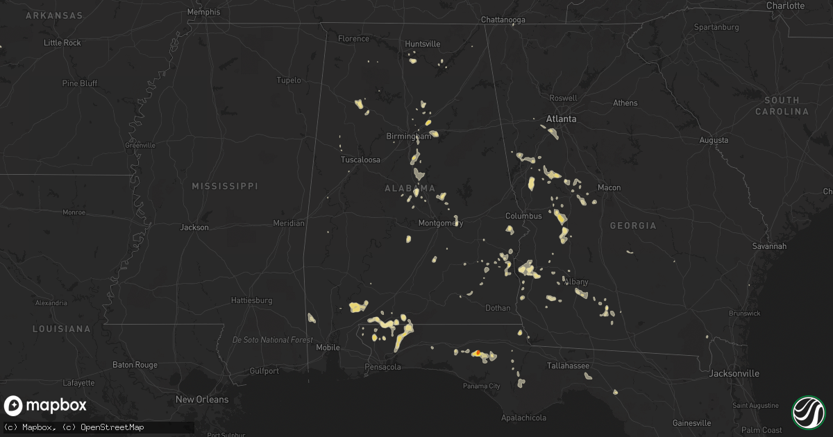
Hail Map in Alabama on June 26, 2016
Get this storm
June 26 map
$229
one time, instant access
Download today. No call, no setup
Keep the $229
Bought the map and want the full workflow? Apply the entire $229 to a subscription within 7 days. None of it is wasted.
Every map, not just this one
This buys you this map. Subscription and you get every map we run, in the markets you choose from a few cities to whole states to nationwide. Plus real-time alerts the moment a storm fires.
Contact data
Name, contact info, occupancy, even credit band for addresses in the footprint. You go from where it hit to who to call.
Become the source they trust
Unlimited branding weather history reports on demand. You already have the documented answer ready for the property owner, and you are the one who showed up with it.
Property data and RoofTrace estimates
Pull up any address you have got, its value and the exact code rules for that jurisdiction, straight from One Click Code. Then RoofTrace estimates the squares, pitch, and roof value, priced the way you price.
Storm reports in Alabama
Alabama
| Date | Description |
|---|---|
| 06/26/20166:55 PM CDT | Several trees down. One tree on home. |
| 06/26/20166:01 PM CDT | Two small trees were blown down and a tractor barn was destroyed near clanton. Winds were estimated around 50 mph. |
| 06/26/20164:50 PM CDT | Large tree down on hwy 50 just east of honoraville |
| 06/26/20163:42 PM CDT | Trees were blown down near the intersection of oswichee road and greenburt road. |
| 06/25/20168:05 PM CDT | Reports of a tree on a house along harris street in atmore. |
| 06/25/20167:10 PM CDT | Trees down on mcgougin road... Wood rd... And edendale rd |
All States Impacted by Hail Map on June 26, 2016
Cities Impacted by Hail Map on June 26, 2016
- Honoraville, AL
- Floral City, FL
- Bushnell, FL
- Stilwell, KS
- Overland Park, KS
- Kansas City, MO
- Belton, MO
- Burlington, OK
- Cherokee, OK
- Hyannis, NE
- Spring Hill, KS
- Bucyrus, KS
- Wolf Point, MT
- Frazer, MT
- Larslan, MT
- Wimauma, FL
- Manchester, OK
- Wakita, OK
- Happy, TX
- Marathon, TX
- Nauvoo, AL
- Carbon Hill, AL
- Eldridge, AL
- Atmore, AL
- Little River, AL
- Fort Stockton, TX
- Pennington, AL
- Olathe, KS
- Warrensburg, MO
- Tryon, NE
- Oak Grove, MO
- Bates City, MO
- Holden, MO
- Odessa, MO
- Seale, AL
- Hatchechubbee, AL
- New Bloomfield, MO
- Louisburg, KS
- Cleveland, MO
- Fargo, OK
- Amarillo, TX
- Clanton, AL
- McDavid, FL
- Brewton, AL
- Flomaton, AL
- Jay, FL
- Century, FL
- Blountstown, FL
- Clarksville, FL
- Mullen, NE
- Whitman, NE
- Ozona, TX
- Yukon, OK
- Piedmont, OK
- Greenville, GA
- Seneca, NE
- Banks, AL
- Enid, OK
- Nash, OK
- Montgomery, AL
- Pike Road, AL
- Naples, FL
- Donalsonville, GA
- Miami, TX
- Gotebo, OK
- Mokane, MO
- Cedar Key, FL
- Inglis, FL
- Chiefland, FL
- Baker, FL
- Milton, FL
- Ariton, AL
- Cordell, OK
- Springville, AL
- Trussville, AL
- Odenville, AL
- Mulberry Grove, IL
- Pocahontas, IL
- Greenville, IL
- Smithboro, IL
- Vernon, FL
- Chipley, FL
- Coats, KS
- Fulton, MO
- Steedman, MO
- Gatewood, MO
- Creighton, MO
- Canyon, TX
- Claude, TX
- Perryton, TX
- Bay Saint Louis, MS
- Valentine, NE
- Butler, MO
- Highland Home, AL
- McHenry, MS
- Saucier, MS
- Lexington, NE
- Holyoke, CO
- Jessieville, AR
- Andalusia, AL
- Canadian, TX
- Sun City, KS
- Viola, KS
- Cheney, KS
- Eustis, NE
- Bessemer, AL
- Reydon, OK
- Cheyenne, OK
- Red Rock, OK
- Morris, GA
- Minter, AL
- Tyler, AL
- Calera, AL
- Shelby, AL
- Jemison, AL
- Jefferson City, MO
- Medford, OK
- Webster, FL
- Dade City, FL
- Wheeler, IL
- Newton, GA
- Arlington, GA
- Leary, GA
- Arnett, OK
- Gage, OK
- Shattuck, OK
- Meriden, KS
- Wayside, TX
- Molena, GA
- Gay, GA
- Thomaston, GA
- Woodbury, GA
- Crane, TX
- Odessa, TX
- Fairview, OK
- Mauk, GA
- Box Springs, GA
- Comstock, TX
- Barney, GA
- Moultrie, GA
- Sonora, TX
- Houstonia, MO
- La Monte, MO
- California, MO
- Curtis, NE
- Overton, NE
- Elm Creek, NE
- Geuda Springs, KS
- Polk City, FL
- Chester, OK
- Lonedell, MO
- Grubville, MO
- Norman Park, GA
- Frisco City, AL
- Strasburg, CO
- Onarga, IL
- Wellsville, KS
- Haxtun, CO
- Ada, OH
- Briscoe, TX
- Wheeler, TX
- Taloga, OK
- Monticello, FL
- Lamont, FL
- Holts Summit, MO
- Tebbetts, MO
- Saint Cloud, FL
- Champion, NE
- Lagrange, IN
- Hereford, TX
- Pell City, AL
- Fort Gaines, GA
- Hayneville, AL
- Roberta, GA
- Fayette, AL
- Kennedy, AL
- Madison, AL
- Albion, IL
- Ooltewah, TN
- Hydro, OK
- Stockville, NE
- Moorefield, NE
- Caldwell, KS
- Bluff City, KS
- Walnut Ridge, AR
- Loda, IL
- Clarendon, TX
- Lelia Lake, TX
- Wallace, NE
- Sutherland, NE
- Hershey, NE
- Dickens, NE
- Clayton, AL
- Ponca City, OK
- Dryden, TX
- Harrisonville, MO
- Archie, MO
- Amherst, CO
- La Follette, TN
- Evening Shade, AR
- Arthur, NE
- Molino, FL
- Patton, MO
- Citronelle, AL
- Altus, OK
- Columbiana, AL
- Montevallo, AL
- Pelham, AL
- Chelsea, AL
- Alabaster, AL
- Ravenden, AR
- Cherokee Village, AR
- Imboden, AR
- Ravenden Springs, AR
- Williford, AR
- Hardy, AR
- Cuthbert, GA
- Coleman, GA
- Lovington, IL
- Perry, FL
- New Brockton, AL
- Enterprise, AL
- Morrisonville, IL
- Pearlington, MS
- Fort Morgan, CO
- Snyder, CO
- Hillrose, CO
- Brush, CO
- Franklin, GA
- Hogansville, GA
- Grantville, GA
- Cartwright, ND
- Greenwood, FL
- Bascom, FL
- Sneads, FL
- Alva, FL
- Lehigh Acres, FL
- Summerfield, TX
- Pass Christian, MS
- Cerro Gordo, IL
- Townley, AL
- Eufaula, AL
- Richwood, OH
- Marysville, OH
- Talbotton, GA
- Gardner, KS
- Eudora, KS
- Edgerton, KS
- Yuma, CO
- Blakely, GA
- Hennessey, OK
- Stapleton, NE
- Bunker, MO
- Guntersville, AL
- Salem, AR
- Gibson City, IL
- Melvin, IL
- Paxton, IL
- Danville, KS
- Harper, KS
- Lone Jack, MO
- Centerview, MO
- Mayview, MO
- Grain Valley, MO
- Knoxville, GA
- Musella, GA
- Pawhuska, OK
- Mustang, OK
- Thedford, NE
- Ponce De Leon, FL
- Boligee, AL
- Merriman, NE
- Attica, KS
- Longdale, OK
- Fort Supply, OK
- Brooksville, FL
- Glenallen, MO
- Greenville, MO
- Sweetwater, OK
- Immokalee, FL
- Burbank, OK
- Fairfax, OK
- Whitwell, TN
- Palmer, TN
- Elsie, NE
- Cleveland, AL
- Lakeville, IN
- Plymouth, IN
- Callaway, NE
- Perry, OK
- Centertown, MO
- Maxwell, NE
- Paola, KS
- Maywood, NE
- Paxton, NE
- Hayes Center, NE
- Wellfleet, NE
- North Platte, NE
- Uriah, AL
- Claremont, IL
- Hammon, OK
- Winter Haven, FL
- Lake Alfred, FL
- Ellery, IL
- Abbeville, AL
- Crystal River, FL
- Akron, CO
- Carmen, OK
- Raymond, OH
- Lagrange, GA
- Pine Mountain, GA
- Kremlin, OK
- Circle, MT
- Piqua, OH
- Erick, OK
- Fountain, FL
- Vinita, OK
- Bluejacket, OK
- Poplar, MT
- Mount Pleasant, AR
- Batesville, AR
- Jackson, AL
- Isabel, KS
- Trafford, AL
- Knob Noster, MO
- Crawford, OK
- Billings, OK
- Marland, OK
- Tonkawa, OK
- Gordo, AL
- Peculiar, MO
- Olustee, OK
- Brockton, MT
- Mangum, OK
- Topeka, KS
- Grant, AL
- Ramer, AL
- Ellaville, GA
- Buena Vista, GA
- Rupert, GA
- Collierville, TN
- Byhalia, MS
- Tampa, FL
- Headrick, OK
- Elba, AL
- Leawood, KS
- Friona, TX
- Pilot Grove, MO
- Baconton, GA
- Abbeville, GA
- Sawyer, KS
- Imperial, MO
- Jasonville, IN
- Louisville, AL
- Clio, AL
- Huntsville, AL
- Holdenville, OK
- Albany, GA
- Vienna, MO
- Dixon, MO
- Sedgewickville, MO
- Plato, MO
- Medicine Lodge, KS
- Bourbon, MO
- Potosi, MO
- Verbena, AL
- Ulman, MO
- Iberia, MO
- Tuscumbia, MO
- Hedley, TX
- Amsterdam, MO
- Sharon, KS
- Pipe Creek, TX
- Bandera, TX
- Cashion, OK
- Junction City, GA
- Butler, GA
- Defuniak Springs, FL
- Freeport, FL
- Omega, GA
- Sumner, GA
- Brady, NE
- North Liberty, IN
- Bremen, IN
- South Bend, IN
- Bluffton, IN
- Shamrock, TX
- Lutz, FL
- Wesley Chapel, FL
- Cleveland, TN
- Pittsview, AL
- Chillicothe, TX
- Michigan City, IN
- Pittsburg, KS
- Galena, KS
- Weir, KS
- Wray, CO
- Morris, AL
- Riverdale, GA
- Fairburn, GA
- Fayetteville, GA
- Atlanta, GA
- Union City, GA
- Spring Hill, FL
- Rantoul, KS
- Ottawa, KS
- Auburndale, FL
- Lakeland, FL
- Loose Creek, MO
- Robinson, IL
- Beverly Hills, FL
- Lecanto, FL
- Jet, OK
- Doerun, GA
- Marion, OH
- Caledonia, OH
- Bucyrus, OH
- Titus, AL
- Remlap, AL
- Venus, FL
- Arcadia, FL
- Wing, AL
- Bristol, FL
- Ash Flat, AR
- Black Rock, AR
- Pocahontas, AR
- Olney, IL
- Dundas, IL
- La Crosse, IN
- Raton, NM
- Hazlehurst, GA
- Whitewater, MO
- Stockton, AL
- Ames, OK
- West Plains, MO
- Clarksville, AR
- Plantersville, AL
- Welch, OK
- Nevada, OH
- Union Springs, AL
- Weston, CO
- Lindsay, MT
- Americus, GA
- Plains, GA
- Crescent City, IL
- Snyder, OK
- Grady, NM
- Damascus, GA
- Zolfo Springs, FL
- Canehill, AR
- Marion, KY
- Hartsburg, MO
- Strafford, MO
- Francesville, IN
- Dunlap, TN
- Mclean, TX
- Salem, MO
- Markle, IN
- Ogallala, NE
- Wetumpka, AL
- Birmingham, AL
- Bartow, FL
- Parkersburg, IL
- West Salem, IL
- Napoleon, OH
- Manchester, GA
- Oklahoma City, OK
- Columbus, KS
- Garden City, MO
- Sarasota, FL
- Bradenton, FL
- Goshen, IN
- Clarksburg, MO
- Marbury, AL
- Deatsville, AL
- Springfield, MO
- Equality, AL
- Rockford, AL
- Kilbourne, IL
- Land O'Lakes, FL
- Moreland, GA
- Moulton, AL
- Saint Elizabeth, MO
- Newton, IL
- Sweet Springs, MO
- Eddyville, IL
- Somerville, AL
- Portland, MO
- Rhineland, MO
- Dover, OK
- Jamestown, MO
- Prairie Home, MO
- Eldorado, TX
- Roswell, NM
- Luthersville, GA
- Winston, GA
- Douglasville, GA
- Sparks, GA
- Fort Valley, GA
- Lebanon Junction, KY
- Arapahoe, NE
- Culloden, GA
- Riverview, FL
- Sedalia, MO
- Hughesville, MO
- Nelson, MO
- Floyd, NM
- Atascosa, TX
- Saint Joseph, IL
- Gifford, IL
- Farnam, NE
- Marble Hill, MO
- Folkston, GA
- Cropwell, AL
- Barnhart, MO
- Arnold, MO
- Middlebury, IN
- Ellenton, GA
- Altha, FL
- Gulfport, MS
- Rensselaer, IN
- Wanette, OK
- Shipshewana, IN
- Topeka, IN
- Granite City, IL
- Meta, MO
- Columbus, OH
- Waynoka, OK
- Reading, MI
- Camden, MI
- Hillsdale, MI
- Slidell, LA
- New Orleans, LA
- Sullivan, IL
- Findlay, IL
- Saint Louis, MO
- Bluffton, AR
- Plainview, AR
- Cambridge, NE
- Urich, MO
- Lees Summit, MO
- Mooreland, OK
- Parrish, FL
- Dittmer, MO
- Lynchburg, MO
- Town Creek, AL
- Mount Hope, AL
- Seiling, OK
- Valhermoso Springs, AL
- Troy, AL
- Montrose, IL
- Winfield, KS
- Henagar, AL
- Pisgah, AL
- Oneida, TN
- Freeburg, MO
- Broadview, NM
- Marshall, MO
- Houston, AL
- Billingsley, AL
- Tucson, AZ
- Lapine, AL
- Dimmitt, TX
- Vinegar Bend, AL
- Smithland, KY
- Townsend, GA
- Marianna, FL
- Laceys Spring, AL
- Holbrook, NE
- Corn, OK
- Des Arc, MO
- Patterson, MO
- Maplesville, AL
- Knoxville, AL
- Fosters, AL
- Ralph, AL
- Preston, GA
- Georgetown, GA
- Leeds, AL
- Moody, AL
- Maryville, IL
- Collinsville, IL
- Chattanooga, TN
- Ringgold, GA
- Pleasanton, KS
- Amoret, MO
- Foster, MO
- Stanton, AL
- Oneonta, AL
- Eglin Afb, FL
- Pond Creek, OK
- Yale, IL
- Watseka, IL
- Concordia, MO
- Syracuse, MO
- Otterville, MO
- Okeechobee, FL
- Calvert City, KY
- Ledbetter, KY
- Brookport, IL
- Paducah, KY
- Long Beach, MS
- Sumterville, FL
- Higginsville, MO
- Fort Myers, FL
- Estero, FL
- Westphalia, MO
- Bonnots Mill, MO
- Dawson, GA
- Inverness, FL
- Brumley, MO
- Nowata, OK
- Midway, AL
- Davenport, FL
- Clermont, FL
- Okeene, OK
- Yatesville, GA
- Keystone, IN
- Lithia, FL
- Mulberry, FL
- Oconee, IL
- Tower Hill, IL
- Leesburg, GA
- Tallassee, AL
- Byron, GA
- Kearney, NE
- Gibbon, NE
- Warm Springs, GA
- Hamilton, GA
- Pine Mountain Valley, GA
- Decatur, IN
- Gravelly, AR
- De Soto, KS
- Perryville, MO
- Woodward, OK


