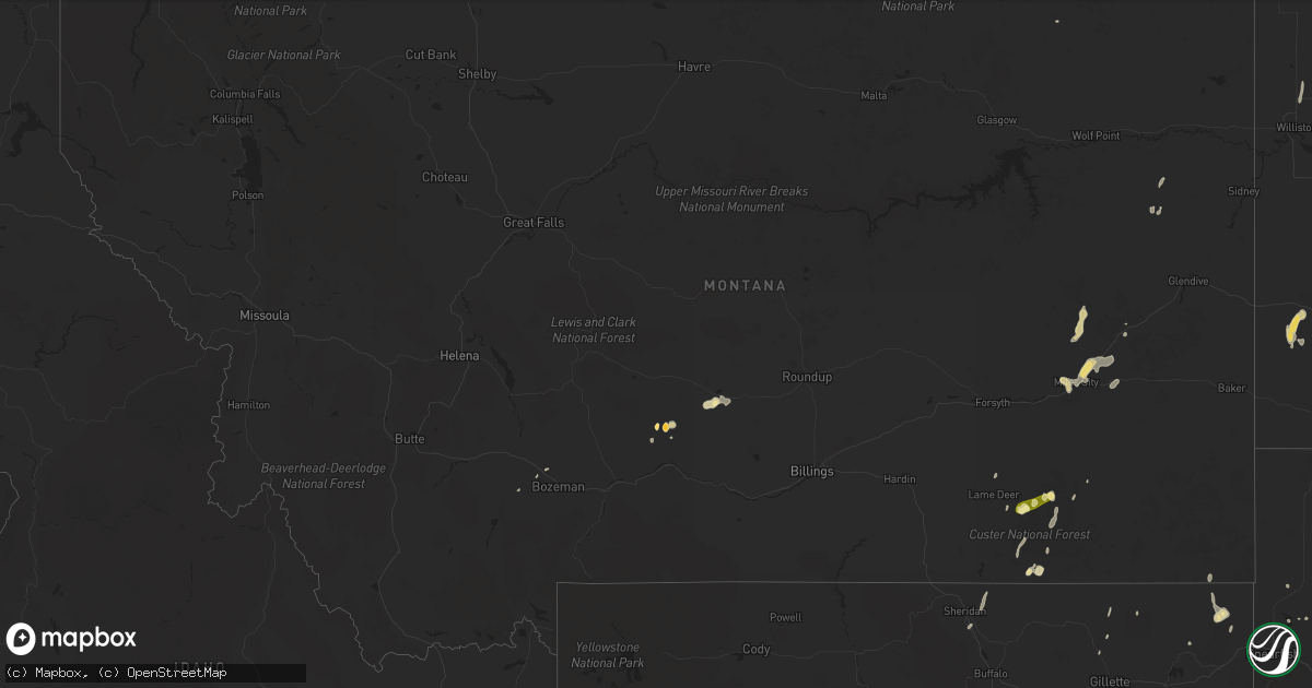
Hail Map in Montana on June 26, 2014
Get this storm
June 26 map
$229
one time, instant access
Download today. No call, no setup
Keep the $229
Bought the map and want the full workflow? Apply the entire $229 to a subscription within 7 days. None of it is wasted.
Every map, not just this one
This buys you this map. Subscription and you get every map we run, in the markets you choose from a few cities to whole states to nationwide. Plus real-time alerts the moment a storm fires.
Contact data
Name, contact info, occupancy, even credit band for addresses in the footprint. You go from where it hit to who to call.
Become the source they trust
Unlimited branding weather history reports on demand. You already have the documented answer ready for the property owner, and you are the one who showed up with it.
Property data and RoofTrace estimates
Pull up any address you have got, its value and the exact code rules for that jurisdiction, straight from One Click Code. Then RoofTrace estimates the squares, pitch, and roof value, priced the way you price.
Storm reports in Montana
Montana
| Date | Description |
|---|---|
| 06/26/20146:00 PM CDT | 2 inches of accumulated hail on the ground. Winds 40 to 50 mph |
| 06/26/20144:35 PM CDT | 0.44 inches of rain in 10 minutes from 1525-1535. |
| 06/25/20147:40 PM CDT | A local report indicates 65 MPH wind near 12 W PLEVNA |
| 06/25/20147:32 PM CDT | A local report indicates 65 MPH wind near 13 W PLEVNA |
All States Impacted by Hail Map on June 26, 2014
Cities Impacted by Hail Map on June 26, 2014
- Alva, WY
- Aladdin, WY
- Benton, MO
- Sikeston, MO
- Charleston, MO
- Scott City, MO
- Carleton, NE
- Lame Deer, MT
- Ashland, MT
- Belleville, KS
- Woodbine, IA
- Sutherland, NE
- Marquette, NE
- Dunlap, IA
- Bunnell, FL
- Moville, IA
- Correctionville, IA
- Hooper, NE
- Fremont, NE
- Yoder, WY
- Champion, NE
- Zap, ND
- Beulah, ND
- Mankato, KS
- Superior, NE
- Wilmore, KS
- Edgemont, SD
- Malvern, IA
- Joes, CO
- Cope, CO
- Paisley, FL
- Melville, MT
- Big Timber, MT
- Sebring, FL
- Lake Placid, FL
- George, IA
- Monroe, NE
- Genoa, NE
- Newcastle, WY
- Bridgeport, NE
- Vona, CO
- Dickinson, ND
- Paxton, NE
- Battle Creek, IA
- Danbury, IA
- Wauneta, NE
- Valentine, NE
- Ocklawaha, FL
- Weirsdale, FL
- Central City, NE
- Manhattan, MT
- Avoca, IA
- Shelby, IA
- Birney, MT
- Ridgeview, SD
- Eagle Butte, SD
- Holstein, IA
- Cushing, IA
- Kimball, NE
- Bushnell, NE
- Logan, IA
- Stockton, KS
- Scranton, ND
- Highmore, SD
- Yuma, CO
- Fort Stockton, TX
- Custer, SD
- Smith Center, KS
- Sanborn, IA
- Sibley, IA
- Melvin, IA
- Ashton, IA
- Okeechobee, FL
- Anton, CO
- Dade City, FL
- Charter Oak, IA
- Moorhead, IA
- Soldier, IA
- Dow City, IA
- Ute, IA
- Akron, CO
- Burns, WY
- Hillsdale, WY
- Deshler, NE
- Isabel, KS
- Nashville, KS
- Medicine Lodge, KS
- Bruno, NE
- Prague, NE
- Merriman, NE
- Casper, WY
- Fontanelle, IA
- Taylor, ND
- Otter, MT
- Agra, KS
- Kensington, KS
- Phillipsburg, KS
- Midland, SD
- Oneill, NE
- Grover, CO
- Omaha, NE
- Fort Calhoun, NE
- Dawson, NE
- Salem, NE
- Palisade, NE
- Sheldon, IA
- Hospers, IA
- Rapid City, SD
- Alliance, NE
- Gordon, NE
- Rushville, NE
- Hay Springs, NE
- Lefor, ND
- Gladstone, ND
- Lance Creek, WY
- Oberlin, KS
- Wahoo, NE
- Martin, SD
- Osborne, KS
- Alton, KS
- Natoma, KS
- Lander, WY
- Chandler, MN
- Ree Heights, SD
- Scribner, NE
- Dodge, NE
- Fort Davis, TX
- Gillette, WY
- Kaycee, WY
- Oakland, NE
- Lyons, NE
- Kilgore, NE
- Saint Francis, SD
- Lynch, NE
- Kinsey, MT
- Ismay, MT
- Miles City, MT
- Carthage, SD
- De Smet, SD
- Orleans, NE
- Seibert, CO
- Stratton, CO
- Flagler, CO
- Debary, FL
- Leigh, NE
- Creston, NE
- Waterloo, NE
- Columbus, NE
- Floral City, FL
- Bushnell, FL
- Nobleton, FL
- Brooksville, FL
- Edgar, NE
- Greenfield, IA
- East Prairie, MO
- Saint Francis, KS
- Winslow, NE
- Uehling, NE
- Shawmut, MT
- Ocheyedan, IA
- Meadow, SD
- Volborg, MT
- Broadus, MT
- Lusk, WY
- Medora, ND
- Belfield, ND
- Peerless, MT
- Forsyth, MT
- Scandia, KS
- Munden, KS
- McCook, NE
- Golden Valley, ND
- Elkhorn, NE
- Springfield, NE
- Gretna, NE
- Burr Oak, KS
- Jeffrey City, WY
- Miller, SD
- Atwood, KS
- Adel, IA
- Palmer, NE
- Fullerton, NE
- Hattiesburg, MS
- Sumrall, MS
- Colon, NE
- Limon, CO
- Aurora, NE
- Hayes Center, NE
- Vernon, CO
- Tuthill, SD
- Cody, NE
- Danbury, NE
- Naples, FL
- Burlington, CO
- Verdon, NE
- Brainard, NE
- Dwight, NE
- Roseland, LA
- Republic, KS
- Herndon, KS
- Mullinville, KS
- New Salem, ND
- Glen Ullin, ND
- Shelby, NE
- Terry, MT
- Richey, MT
- Crookston, NE
- West Point, NE
- Turon, KS
- Bison, KS
- Rush Center, KS
- Carpenter, WY
- Hawk Springs, WY
- Utica, KY
- McDonald, KS
- Harrisville, MS
- Regent, ND
- Culbertson, NE
- North Loup, NE
- Iona, MN
- Maxbass, ND
- Lagrange, WY
- Sentinel Butte, ND
- South Heart, ND
- Orange City, IA
- Salt Flat, TX
- Verdigre, NE
- Holyoke, CO
- Imperial, NE
- Eckley, CO
- Otis, CO
- Wray, CO
- Stafford, KS
- Halliday, ND
- Richardton, ND
- Arapahoe, WY
- Riverton, WY
- Vale, SD
- Newell, SD
- Hemingford, NE
- Lindsay, NE
- Hebron, NE
- Gilead, NE
- Sun City, KS
- Lake City, KS
- Buffalo, WY
- Beaver City, NE
- Hendley, NE
- Norton, KS
- Lenora, KS
- Plainview, NE
- Stella, NE
- Gregory, SD
- Winner, SD
- Dallas, SD
- Hamill, SD
- North Fort Myers, FL
- Punta Gorda, FL
- Athol, KS
- Deland, FL
- Boyden, IA
- Pisgah, IA
- Sheridan, WY
- Portsmouth, IA
- Persia, IA
- King City, MO
- Union Star, MO
- Loxahatchee, FL
- Dix, NE
- Potter, NE
- Bayard, NE
- Harrisburg, NE
- Wimauma, FL
- Bethune, CO
- Mandaree, ND
- Killdeer, ND
- Dexter, KS
- Cambridge, KS
- Cunningham, KS
- Hancock, IA
- Walnut, IA
- Mission, SD
- Rosebud, SD
- Orient, IA
- Weston, WY
- New Town, ND
- Hardwick, MN
- Edgerton, MN
- St John, KS
- Knoxville, IA
- Ten Sleep, WY
- North Bend, NE
- Benkelman, NE
- Scotia, NE
- Upham, ND
- Long Island, KS
- Belgrade, NE
- Alva, FL
- Courtland, KS
- Bonesteel, SD
- Fairfax, SD
- Niobrara, NE
- Cedar Creek, NE
- Box Elder, SD
- Tekamah, NE
- Altoona, FL
- Helena, MO
- Winnetoon, NE
- Hugo, CO
- Williston, ND
- New Underwood, SD
- Sturgis, SD
- Nunn, CO
- Sarasota, FL
- Ceresco, NE
- Weston, NE
- Calhoun, KY
- Livermore, KY
- Earlham, IA
- Clive, IA
- Van Meter, IA
- Urbandale, IA
- West Des Moines, IA
- Winterset, IA
- De Soto, IA
- Dallas Center, IA
- Booneville, IA
- Waukee, IA
- Wolbach, NE
- Lake Andes, SD
- Silsbee, TX
- Fred, TX
- Decker, MT
- Indianola, IA
- Grant, NE
- Wagner, SD
- Julesburg, CO
- Malmo, NE
- Esbon, KS
- Lebanon, KS
- Craig, NE
- Decatur, NE
- Sundance, WY
- Valley, NE
- Yutan, NE
- Mead, NE
- Missouri Valley, IA
- West Concord, MN
- Springfield, SD
- Bison, SD
- South Fulton, TN
- New England, ND
- Belle Fourche, SD
- De Leon Springs, FL
- Pierson, FL
- Idalia, CO
- Dunn Center, ND
- York, NE
- Ashland, NE
- Hill City, SD
- Linwood, NE
- Carson, IA
- Ithaca, NE
- Indianola, NE
- David City, NE
- Fairbury, NE
- Seward, NE
- Venango, NE
- Atkinson, NE
- Alma, NE
- Cheyenne, WY
- Ryegate, MT
- Fort Myers, FL
- Burke, SD
- Saint Charles, SD
- Harrison, NE
- Herrick, SD
- Bird City, KS
- Manning, ND
- Wheatland, WY
- Parrish, FL
- Piedmont, SD
- Black Hawk, SD
- Gaylord, KS
- Ideal, SD
- Wood, SD
- Rogers, NE
- Morse Bluff, NE
- Snyder, NE
- Dupree, SD
- Lysite, WY
- Worthington, MN
- Denison, IA
- Arion, IA
- Venus, FL
- Conception, MO
- Stanberry, MO
- Guilford, MO
- Belgrade, MT
- Waverly, NE
- Kenansville, FL
- Rose Hill, NC
- Magnolia, NC
- Republican City, NE
- Fairfield, ND
- Clarks, NE
- Polk, NE
- Stromsburg, NE
- Kirk, CO
- Norcatur, KS
- Nashville, AR
- Pratt, KS
- Nickerson, NE
- Cedar Bluffs, NE
- Herman, NE
- Laketown, UT
- Marsland, NE
- Bristol, FL
- Winfield, KS
- Ord, NE
- Cedar Rapids, NE
- Bertrand, MO
- Broadwater, NE
- Dante, SD
- Nelson, NE
- Ruskin, NE
- Rock Rapids, IA
- Doon, IA
- Sawyer, KS
- Stanley, ND
- Glenburn, ND
- Lansford, ND
- White River, SD
- Waldo, KS
- Saint Augustine, FL
- Alzada, MT
- Davenport, NE
- Oak, NE
- Hebron, ND
- Grassy Butte, ND
- Harlan, IA
- Geddes, SD
- Earling, IA
- Panama, IA
- Slayton, MN
- Minden, IA
- Arcadia, FL
- Pierson, IA
- Kingsley, IA
- Anthon, IA
- Hulett, WY
- Fort Myers Beach, FL
- Carr, CO
- Ames, NE
- Ludlow, SD
- Dawson, MN
- Warren, TX
- Chadron, NE
- Stamford, NE
- Hamlin, IA
- Audubon, IA
- Willard, NC
- Raymond, NE
- Almena, KS
- Webber, KS
- Platte, SD
- Creighton, NE
- Ogallala, NE
- Fleming, CO
- Hordville, NE
- Devils Tower, WY
- Waldron, KS
- Hazelton, KS
- Clarkfield, MN
- Trenton, NE
- Stratton, NE
- Donnybrook, ND
- Bellwood, NE
- Rising City, NE
- Ulysses, NE
- Surprise, NE
- Ocala, FL
- Ashton, NE
- Garland, NE
- Bee, NE
- Valparaiso, NE
- Genoa, CO
- Oxford, NE
- Torrington, WY


