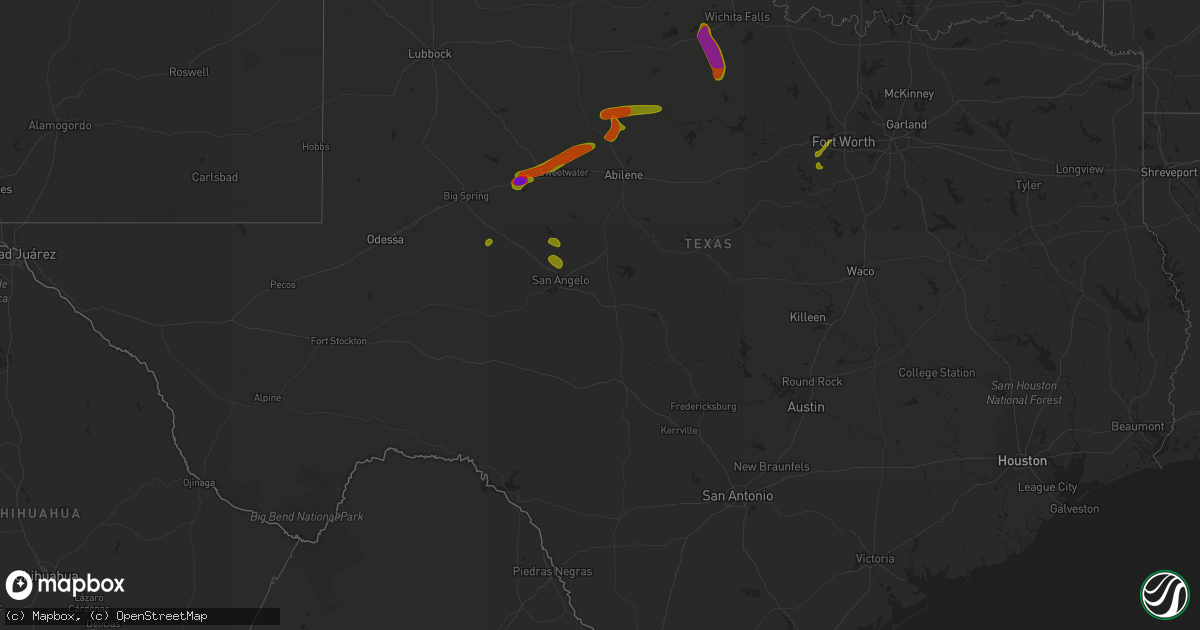
Hail Map in Texas on June 23, 2018
Get this storm
June 23 map
$229
one time, instant access
Download today. No call, no setup
Keep the $229
Bought the map and want the full workflow? Apply the entire $229 to a subscription within 7 days. None of it is wasted.
Every map, not just this one
This buys you this map. Subscription and you get every map we run, in the markets you choose from a few cities to whole states to nationwide. Plus real-time alerts the moment a storm fires.
Contact data
Name, contact info, occupancy, even credit band for addresses in the footprint. You go from where it hit to who to call.
Become the source they trust
Unlimited branding weather history reports on demand. You already have the documented answer ready for the property owner, and you are the one who showed up with it.
Property data and RoofTrace estimates
Pull up any address you have got, its value and the exact code rules for that jurisdiction, straight from One Click Code. Then RoofTrace estimates the squares, pitch, and roof value, priced the way you price.
Storm reports in Texas
Texas
| Date | Description |
|---|---|
| 06/23/20187:28 AM CDT | At 1228 AM CDT, severe thunderstorms were located along a line extending from 4 miles west of Scipio to near Stonewall to 4 miles southwest of Lone Grove, moving southeast at 40 mph. HAZARD...60 mph wind gusts. SOURCE...Radar indicated. IMPACT...Expect damage to roofs, siding, and trees. Locations impacted include... Ardmore, Duncan, Ada, Durant, Pauls Valley, Holdenville, Sulphur, Marlow, Madill, Atoka, Tishomingo, Davis, Marietta, Coalgate, Lone Grove, Healdton, Wynnewood, Wilson, Kingston and Stratford. |
| 06/23/20185:49 AM CDT | At 1048 PM CDT, severe thunderstorms were located along a line extending from Throckmorton to near Eula, moving east at 25 mph. HAZARD...60 mph wind gusts and penny size hail. SOURCE...Radar indicated. IMPACT...Expect damage to roofs, siding, and trees. These severe thunderstorms will remain over mainly rural areas of northeastern Callahan...eastern Shackelford and southeastern Throckmorton Counties, including the following locations... Mccarty Lake, The Intersection Of Us-183 And Us-283, Lusk, Admiral, Us-283 Near The Callahan-Shackelford County Line, The Intersection Of Us-283 And Ranch Road 209, Us-180 Near The Shackelford-Stephens County Line and I-20 Near The Callahan-Eastland County Line.This includes Interstate 20 between Mile Markers 304 and 323. |
| 06/23/20185:43 AM CDT | At 1043 PM CDT, a severe thunderstorm was located near Olney, moving south at 15 mph. This is a very dangerous storm. HAZARD...80 mph wind gusts and softball size hail. SOURCE...Radar indicated. IMPACT...Flying debris will be dangerous to those caught without shelter. Mobile homes will be heavily damaged. Expect considerable damage to roofs, windows, and vehicles. Extensive tree damage and power outages are likely. This severe thunderstorm will remain over mainly rural areas of south central Archer County. |
| 06/23/20185:19 AM CDT | At 1018 PM CDT, a severe thunderstorm was located near Clyde, moving east at 30 mph. HAZARD...60 to 65 mph wind gusts and quarter size hail. SOURCE...Radar indicated. IMPACT...Hail damage to vehicles is expected. Expect wind damage to roofs, siding, and trees. This severe thunderstorm will be near, Baird around 1025 PM CDT. Putnam around 1050 PM CDT. Moran around 1100 PM CDT.Other locations impacted by this severe thunderstorm include I-20 Near The Callahan-Eastland County Line and Us-283 Near The Callahan-Shackelford County Line.This includes Interstate 20 between Mile Markers 293 and 323. |
| 06/23/20185:11 AM CDT | At 1011 PM CDT, a severe thunderstorm was located 8 miles southwest of Archer City, moving southeast at 25 mph. HAZARD...Golf ball size hail and 70 mph wind gusts. SOURCE...Radar indicated. IMPACT...People and animals outdoors will be injured. Expect hail damage to roofs, siding, windows, and vehicles. Expect considerable tree damage. Wind damage is also likely to mobile homes, roofs, and outbuildings. Locations impacted include... Graham, Jacksboro, Olney, Bryson and Newcastle. |
| 06/23/20184:53 AM CDT | At 952 PM CDT, a severe thunderstorm was located 4 miles southeast of Lake Kickapoo, moving southeast at 20 mph. This is a very dangerous storm. HAZARD...80 mph wind gusts and three inch hail. SOURCE...Radar indicated. IMPACT...Flying debris will be dangerous to those caught without shelter. Mobile homes will be heavily damaged. Expect considerable damage to roofs, windows, and vehicles. Extensive tree damage and power outages are likely. Locations impacted include... Archer City and Lake Kickapoo. |
| 06/23/20184:43 AM CDT | At 942 PM CDT, a severe thunderstorm was located over Lake Stamford Marina, or 9 miles southeast of Haskell, moving east at 20 mph. HAZARD...Ping pong ball size hail and 60 mph wind gusts. SOURCE...Radar indicated. IMPACT...People and animals outdoors will be injured. Expect hail damage to roofs, siding, windows, and vehicles. Expect wind damage to roofs, siding, and trees. This severe thunderstorm will remain over mainly rural areas of southeastern Haskell...northeastern Jones...northwestern Shackelford and southwestern Throckmorton Counties, including the following locations... The Intersection Of Us-380 And Highway 222. |
| 06/23/20184:23 AM CDT | At 922 PM CDT, a severe thunderstorm was located near Sagerton, or near Stamford, moving northeast at 25 mph. HAZARD...Golf ball size hail and 60 mph wind gusts. SOURCE...Radar indicated. IMPACT...People and animals outdoors will be injured. Expect hail damage to roofs, siding, windows, and vehicles. Expect wind damage to roofs, siding, and trees. This severe thunderstorm will be near, Rule around 940 PM CDT. Haskell around 945 PM CDT. Weinert around 1005 PM CDT. |
| 06/23/20184:18 AM CDT | At 918 PM CDT, a severe thunderstorm was located near Mankins, moving southeast at 25 mph. HAZARD...Golf ball size hail. SOURCE...Radar indicated. IMPACT...People and animals outdoors will be injured. Expect damage to roofs, siding, windows, and vehicles. Locations impacted include... Archer City, Scotland, Dundee, Mankins and Lake Kickapoo. |
| 06/23/20184:09 AM CDT | At 908 PM CDT, a severe thunderstorm was located over Anson, moving east at 20 mph. HAZARD...60 mph wind gusts and half dollar size hail. SOURCE...Radar indicated. IMPACT...Hail damage to vehicles is expected. Expect wind damage to roofs, siding, and trees. This severe thunderstorm will be near, Lueders and Avoca around 925 PM CDT. Fort Griffin around 955 PM CDT.Other locations impacted by this severe thunderstorm include Funston,Big Country Baptist Assembly, The Intersection Of Us-283 And Ranch Road 209 and The Intersection Of Us-180 And Farm Road 600. |
| 06/23/20183:45 AM CDT | At 844 PM CDT, a severe thunderstorm was located 11 miles north of Hobbs, or 21 miles northeast of Snyder near Hudd , moving northeast at 15 mph. HAZARD...Golf ball size hail and 70 mph wind gusts. SOURCE...Radar indicated. IMPACT...People and animals outdoors will be injured. Expect hail damage to roofs, siding, windows, and vehicles. Expect considerable tree damage. Wind damage is also likely to mobile homes, roofs, and outbuildings. This severe thunderstorm will remain over mainly rural areas of northeastern Scurry County. |
| 06/23/20183:41 AM CDT | At 840 PM CDT, severe thunderstorms were located along a line extending from near Tennyson to near Grape Creek to near Water Valley, moving southeast at 35 mph. HAZARD...70 mph wind gusts and quarter size hail. SOURCE...Radar indicated. IMPACT...Hail damage to vehicles is expected. Expect considerable tree damage. Wind damage is also likely to mobile homes, roofs, and outbuildings. Severe thunderstorms will be near, San Angelo, O.c. Fisher Reservoir and San Angelo State Park around 845 PM CDT. Miles, Goodfellow Air Force Base, Rowena and Veribest around 855 PM CDT. Wall, Lowake and Arden around 900 PM CDT. Tankersley, Twin Buttes Reservoir, Mereta and Vancourt around 910 PM CDT. Eola and Lake Nasworthy around 915 PM CDT. Knickerbocker around 920 PM CDT. Christoval around 925 PM CDT.Other locations impacted by these severe thunderstorms include Vick,The Intersection Of Us-83 And Ranch Road 765, The Intersection Of Us-83 And Ranch Road 1929, The Intersection Of Highway 208 And RanchRoad 2662, Us-87 Near The Coke-Tom Green County Line, Us-67 Near The Irion-Tom Green County Line, Harriet and The Intersection Of Ranch Road 380And Ranch Road 381. |
| 06/23/20183:40 AM CDT | At 840 PM CDT, a severe thunderstorm was located near Anson, moving east at 20 mph. HAZARD...Golf ball size hail and 70 mph wind gusts. SOURCE...Radar indicated. IMPACT...People and animals outdoors will be injured. Expect hail damage to roofs, siding, windows, and vehicles. Expect considerable tree damage. Wind damage is also likely to mobile homes, roofs, and outbuildings. This severe thunderstorm will be near, Anson around 845 PM CDT. Avoca and Nugent around 900 PM CDT. Lueders around 905 PM CDT.Other locations impacted by this severe thunderstorm include Funston,The Intersection Of Us-180 And Ranch Road 126, Truby, Hitson, The Intersection Of Us-180 And Farm Road 600 and Tuxedo. |
| 06/23/20183:25 AM CDT | At 824 PM CDT, severe thunderstorms were located along a line extending from near Tennyson to 8 miles north of Grape Creek to near Water Valley, moving southeast at 30 mph. HAZARD...70 mph wind gusts and quarter size hail. SOURCE...Radar indicated. IMPACT...Hail damage to vehicles is expected. Expect considerable tree damage. Wind damage is also likely to mobile homes, roofs, and outbuildings. Severe thunderstorms will be near, Grape Creek around 830 PM CDT. Tennyson around 835 PM CDT. San Angelo, Carlsbad and Orient around 845 PM CDT. Miles around 855 PM CDT. San Angelo State Park and O.c. Fisher Reservoir around 905 PM CDT.Other locations impacted by these severe thunderstorms include TheIntersection Of Highway 208 And Ranch Road 2662, Harriet and Us-87 Near The Coke-Tom Green County Line. |
| 06/23/20183:11 AM CDT | At 810 PM CDT, a severe thunderstorm was located near Robert Lee, moving east at 15 mph. HAZARD...60 mph wind gusts and half dollar size hail. SOURCE...Radar indicated. IMPACT...Hail damage to vehicles is expected. Expect wind damage to roofs, siding, and trees. This severe thunderstorm will be near, Robert Lee around 820 PM CDT. Tennyson around 855 PM CDT. Bronte around 900 PM CDT.Other locations impacted by this severe thunderstorm include TheIntersection Of Highway 208 And Ranch Road 2662. |
| 06/23/20183:09 AM CDT | At 808 PM CDT, a severe thunderstorm was located 7 miles southeast of Garden City, moving northeast at 15 mph. HAZARD...Golf ball size hail and 70 mph wind gusts. SOURCE...Radar indicated. IMPACT...People and animals outdoors will be injured. Expect hail damage to roofs, siding, windows, and vehicles. Expect considerable tree damage. Wind damage is also likely to mobile homes, roofs, and outbuildings. Locations impacted include... Highway 158 east of Garden City. |
| 06/23/20183:00 AM CDT | At 759 PM CDT, a severe thunderstorm was located near Longworth, or 10 miles north of Sweetwater, moving northeast at 25 mph. HAZARD...Golf ball size hail and 70 mph wind gusts. SOURCE...Radar indicated. IMPACT...People and animals outdoors will be injured. Expect hail damage to roofs, siding, windows, and vehicles. Expect considerable tree damage. Wind damage is also likely to mobile homes, roofs, and outbuildings. This severe thunderstorm will be near, Roby and Longworth around 810 PM CDT. Sylvester around 820 PM CDT. Mccaulley around 830 PM CDT.Other locations impacted by this severe thunderstorm include TheIntersection Of Us-180 And Ranch Road 126, Gannon, Hitson, Busby and Capitola.This includes Interstate 20 between Mile Markers 238 and 253. |
| 06/23/20182:55 AM CDT | At 754 PM CDT, a severe thunderstorm was located 13 miles west of Sterling City, moving east at 25 mph. HAZARD...Ping pong ball size hail and 60 mph wind gusts. SOURCE...Radar indicated. IMPACT...People and animals outdoors will be injured. Expect hail damage to roofs, siding, windows, and vehicles. Expect wind damage to roofs, siding, and trees. This severe thunderstorm will be near, Sterling City around 830 PM CDT. |
| 06/23/20182:49 AM CDT | At 748 PM CDT, a severe thunderstorm was located over Stamford, moving southeast at 10 mph. HAZARD...Ping pong ball size hail and 60 mph wind gusts. SOURCE...Radar indicated. IMPACT...People and animals outdoors will be injured. Expect hail damage to roofs, siding, windows, and vehicles. Expect wind damage to roofs, siding, and trees. This severe thunderstorm will be near, Avoca around 830 PM CDT.Other locations impacted by this severe thunderstorm include Funstonand Tuxedo. |
| 06/23/20182:28 AM CDT | At 728 PM CDT, a severe thunderstorm was located near Lake Colorado City, or near Colorado City, moving northeast at 15 mph. HAZARD...Golf ball size hail and 70 mph wind gusts. SOURCE...Radar indicated. IMPACT...People and animals outdoors will be injured. Expect hail damage to roofs, siding, windows, and vehicles. Expect considerable tree damage. Wind damage is also likely to mobile homes, roofs, and outbuildings. Locations impacted include... Colorado City, Loraine, Colorado City Airport, Inadale, Lake Colorado City, Champion Creek Reservoir, Lake Colorado City State Park, Westbrook, Hermleigh and Buford.This includes Interstate 20 between mile markers 207 and 228. |
| 06/23/20182:18 AM CDT | At 718 PM CDT, a severe thunderstorm was located near Wastella, or 10 miles west of Roscoe, moving northeast at 25 mph. HAZARD...Two inch hail and 60 mph wind gusts. SOURCE...Radar indicated. IMPACT...People and animals outdoors will be injured. Expect hail damage to roofs, siding, windows, and vehicles. Expect wind damage to roofs, siding, and trees. This severe thunderstorm will be near, Wastella around 725 PM CDT. Roscoe around 735 PM CDT.Other locations impacted by this severe thunderstorm include Gannon,Busby, Capitola, I-20 Near The Nolan-Mitchell County Line and Us-84 Near The Nolan-Fisher County Line.This includes Interstate 20 between Mile Markers 229 and 253. |
| 06/23/20181:49 AM CDT | At 648 PM CDT, a severe thunderstorm was located over Lake Colorado City State Park, or 7 miles southwest of Colorado City, moving northeast at 15 mph. HAZARD...Ping pong ball size hail and 60 mph wind gusts. SOURCE...Radar indicated. IMPACT...People and animals outdoors will be injured. Expect hail damage to roofs, siding, windows, and vehicles. Expect wind damage to roofs, siding, and trees. Locations impacted include... Colorado City, Loraine, Colorado City Airport, Lake Colorado City, Champion Creek Reservoir, Lake Colorado City State Park, Westbrook and Buford.This includes Interstate 20 between mile markers 203 and 226. |
| 06/22/201811:05 PM CDT | A local report indicates 60 MPH wind near E WOODSON |
| 06/22/201811:02 PM CDT | Ping pong ball hail near olney |
| 06/22/20189:57 PM CDT | A local report indicates 1.00 inch wind near 5 NE LAKE KICKAPOO |
| 06/22/20189:55 PM CDT | A local report indicates 1.75 inch wind near 2 NE LAKE KICKAPOO |
| 06/22/20189:50 PM CDT | Late report from last evening. Hail ranged from two to two and a quarter inches in diameter. Time estimated by radar. |
| 06/22/20189:13 PM CDT | A local report indicates 61 MPH wind near 2 E WALL |
| 06/22/20188:56 PM CDT | A local report indicates 1.75 inch wind near 20 NE SNYDER |
| 06/22/20188:55 PM CDT | A local report indicates 72 MPH wind near 7 NW SAN ANGELO |
| 06/22/20188:45 PM CDT | A local report indicates 87 MPH wind near N GRAPE CREEK |
| 06/22/20188:20 PM CDT | East 2nd st. |
| 06/22/20188:18 PM CDT | East 2nd st. |
| 06/22/20188:16 PM CDT | A local report indicates 2.75 inch wind near COLORADO CITY |
| 06/22/20187:47 PM CDT | A local report indicates 1.75 inch wind near 5 N ROSCOE |
| 06/22/20187:43 PM CDT | A local report indicates 1.75 inch wind near 1 E LORAINE |
| 06/22/20187:25 PM CDT | Fm 2836 |
All States Impacted by Hail Map on June 23, 2018
Cities Impacted by Hail Map on June 23, 2018
- Bloomfield, NE
- Wausa, NE
- Wayne, NE
- Carroll, NE
- Stanton, NE
- Winside, NE
- Wisner, NE
- Howells, NE
- Pilger, NE
- Randolph, NE
- Dodge, NE
- West Point, NE
- Hoskins, NE
- Morrill, NE
- Scottsbluff, NE
- Mitchell, NE
- Lexington, NE
- Overton, NE
- Elwood, NE
- Creston, NE
- Lindsay, NE
- Madison, NE
- Newman Grove, NE
- Humphrey, NE
- Leigh, NE
- Rexford, KS
- Hoxie, KS
- Colby, KS
- Oakley, KS
- Oberlin, KS
- Atwood, KS
- Park, KS
- Quinter, KS
- Morland, KS
- Grinnell, KS
- McDonald, KS
- Johnson, KS
- Ulysses, KS
- Arapahoe, CO
- Weskan, KS
- Sharon Springs, KS
- Wallace, KS
- Goodland, KS
- Burlington, CO
- Kanorado, KS
- Garden City, KS
- Ingalls, KS
- Pierceville, KS
- Minneola, KS
- Ford, KS
- Bucklin, KS
- Englewood, KS
- Lusk, WY
- Manville, WY
- Lance Creek, WY
- Midwest, WY
- Topping, VA
- Hardyville, VA
- Wake, VA
- Hartfield, VA
- Deltaville, VA
- Limon, CO
- Agate, CO
- Hugo, CO
- Matheson, CO
- Eads, CO
- Haswell, CO
- Karval, CO
- Kit Carson, CO
- Vona, CO
- Stratton, CO
- Ramah, CO
- Rush, CO
- Arlington, CO
- Genoa, CO
- Arriba, CO
- Devol, OK
- Loveland, OK
- Frederick, OK
- Tipton, OK
- Grandfield, OK
- Walters, OK
- Chandler, OK
- Sparks, OK
- Prague, OK
- Paden, OK
- Okemah, OK
- Weleetka, OK
- Mounds, OK
- Beggs, OK
- Locust Grove, OK
- Chouteau, OK
- Pryor, OK
- Wagoner, OK
- Eufaula, OK
- Hanna, OK
- Krebs, OK
- Mcalester, OK
- Stuart, OK
- Calvin, OK
- Savanna, OK
- Kiowa, OK
- Holdenville, OK
- Seiling, OK
- Vici, OK
- Mutual, OK
- Colorado City, TX
- Sylvester, TX
- Roscoe, TX
- Loraine, TX
- Roby, TX
- Sweetwater, TX
- McCaulley, TX
- Anson, TX
- Stamford, TX
- Avoca, TX
- Robert Lee, TX
- Sterling City, TX
- San Angelo, TX
- Olney, TX
- Windthorst, TX
- Holliday, TX
- Rule, TX
- Haskell, TX
- Throckmorton, TX
- Fort Worth, TX
- Weatherford, TX
- Aledo, TX
- Cresson, TX
- Godley, TX
- Manderson, SD
- Porcupine, SD
- Wounded Knee, SD
- Pine Ridge, SD
- Spencer, SD
- Salem, SD
- Portal, ND
- Watford City, ND
- Kaycee, WY
- Pierre, SD
- Bayard, NE
- Mcgrew, NE
- Bethune, CO
- Norfolk, NE
- Pierce, NE
- Mclean, NE
- Osmond, NE
- Cheyenne Wells, CO
- Mooreland, OK
- Woodward, OK
- Newalla, OK
- Harrah, OK
- Choctaw, OK
- Bartlesville, OK
- Lamont, OK
- Fayette, AL
- Stigler, OK
- Wingate, TX
- Tuscola, TX
- Abilene, TX
- Winters, TX
- Lawn, TX
- Ovalo, TX
- Colt, AR
- Carlsbad, TX
- Fairfield, ND
- Van Tassell, WY
- Harrison, NE
- Crawford, NE
- Marsland, NE
- Trenton, NE
- Yuma, CO
- Akron, CO
- Anton, CO
- Lindon, CO
- Joes, CO
- Cope, CO
- Dodge City, KS
- Fowler, KS
- Amorita, OK
- Kiowa, KS
- Medicine Lodge, KS
- Burlington, OK
- Waldron, KS
- Hazelton, KS
- Oklahoma City, OK
- Bristow, OK
- Boley, OK
- Castle, OK
- Rotan, TX
- Joiner, AR
- Russellville, AL
- Tuscumbia, AL
- Miami, FL
- Montezuma, KS
- Cimarron, KS
- Wakita, OK
- Onancock, VA
- Greenbush, VA
- Accomac, VA
- Bloxom, VA
- Parksley, VA
- Tunica, MS
- Talihina, OK
- Wilburton, OK
- Perry, OK
- Wellston, OK
- Luther, OK
- Kinta, OK
- Whitefield, OK
- Porum, OK
- Epping, ND
- Doole, TX
- Voss, TX
- Millersview, TX
- Garden City, TX
- Central City, NE
- Belgrade, NE
- Egeland, ND
- Willow City, ND
- Checotah, OK
- Anna, IL
- Dongola, IL
- Stillwater, OK
- Moran, TX
- Woodson, TX
- Breckenridge, TX
- Levant, KS
- Bantry, ND
- Caputa, SD
- Faith, SD
- Williston, ND
- Berthold, ND
- Rugby, ND
- White Stone, VA
- Riverton, WY
- Shoshoni, WY
- Valentine, NE
- Cody, NE
- Idaho Falls, ID
- Alva, OK
- Garber, OK
- Hunter, OK
- Tonkawa, OK
- Cypress, IL
- Vienna, IL
- Buncombe, IL
- Edenton, NC
- Earlsboro, OK
- Shawnee, OK
- Seminole, OK
- Columbia, NC
- Memphis, TN
- Vernon, AL
- Wolbach, NE
- Midland, VA
- Gouldbusk, TX
- Headrick, OK
- Elmer, OK
- Niobrara, NE
- Selden, KS
- Calhan, CO
- Wiggins, CO
- Albany, TX
- Clyde, TX
- Orlando, OK
- Oktaha, OK
- Pawnee, OK
- Maramec, OK
- Cleveland, OK
- Jennings, OK
- Glencoe, OK
- Rocklake, ND
- Iron City, TN
- Milesville, SD
- Martin, SD
- Batesland, SD
- Merriman, NE
- Ogallala, NE
- Brule, NE
- Davenport, OK
- Oakwood, OK
- Granbury, TX
- Graham, TX
- Hamlin, TX
- Brewster, KS
- Cisco, TX
- Branson, CO
- Magnet, NE
- Hemingford, NE
- Lake City, KS
- Churchs Ferry, ND
- Swifton, AR
- Tuckerman, AR
- Stroud, OK
- Meeker, OK
- Wetumka, OK
- Henryetta, OK
- Aspermont, TX
- Holcomb, KS
- Deerfield, KS
- Providence Forge, VA
- Red Rock, OK
- Morrison, OK
- Simla, CO
- Winfred, SD
- Mccurtain, OK
- Towner, ND
- Palestine, AR
- Eastland, TX
- Seibert, CO
- Medford, OK
- Hermosa, SD
- Syracuse, KS
- Holly, CO
- Shawnee, WY
- Chester, OK
- Cypress Inn, TN
- El Paso, AR
- Wallops Island, VA
- Onley, VA
- Haviland, KS
- Alamo, ND
- Ray, ND
- Bronte, TX
- Ballinger, TX
- Norton, TX
- Lodge Grass, MT
- Muskogee, OK
- Glen Rose, TX
- Nemo, TX
- Rainbow, TX
- Berryville, AR
- Lampe, MO
- Carney, OK
- Woodrow, CO
- Fort Morgan, CO
- Snyder, TX
- Marland, OK
- Okmulgee, OK
- Talpa, TX
- Quinton, OK
- Norman, OK
- Ludell, KS
- Chappell, NE
- Ovid, CO
- Julesburg, CO
- Keenesburg, CO
- Albion, NE
- Brookport, IL
- Ashland, KS
- Parkin, AR
- Earle, AR
- San Saba, TX
- Gates, NC
- Casper, WY
- Stratton, NE
- Merkel, TX
- Brockton, MT
- Lakota, ND
- Upham, ND
- Carthage, SD
- Howard, SD
- Arnegard, ND
- Brush, CO
- Metropolis, IL
- Cherokee, OK
- Wilmore, KS
- Coldwater, KS
- Terlton, OK
- Yukon, OK
- Bethany, OK
- Hartshorne, OK
- Newcastle, TX
- Baird, TX
- Hermleigh, TX
- Waskish, MN
- Midland, SD
- Philip, SD
- Winona, KS
- Big Springs, NE
- Roggen, CO
- Yale, OK
- Wild Horse, CO
- Gloucester, VA
- Shacklefords, VA
- Saluda, VA
- Putnam, OK
- Copeland, KS
- Atwood, OK
- Douglas, WY
- Arnett, OK
- Manchester, OK
- Cedar Rapids, NE
- Clarkson, NE
- Cobbs Creek, VA
- Edmond, OK
- Palmer, NE
- Saint Libory, NE
- Tribune, KS
- Clarks, NE
- Indianola, OK
- Taloga, OK
- Canton, OK
- Anthony, KS
- Hatton, ND
- Munich, ND
- Shelley, ID
- Culbertson, NE
- Buffalo, OK
- Fay, OK
- Suffolk, VA
- Dustin, OK
- Maud, OK
- Tecumseh, OK
- Leighton, AL
- Bokoshe, OK
- Spiro, OK
- Shady Point, OK
- Poteau, OK
- Grainfield, KS
- Mannford, OK
- Bluff City, KS
- Nash, OK
- Freedom, OK
- Cameron, OK
- Cash, AR
- Dryden, TX
- Belden, NE
- Springfield, SD
- Minatare, NE
- Sedgwick, CO
- Herndon, KS
- Dighton, KS
- Sheridan Lake, CO
- Waynoka, OK
- Caldwell, KS
- Jetmore, KS
- Drumright, OK
- Follett, TX
- Sharon, OK
- Fargo, OK
- Como, NC
- Murfreesboro, NC
- Fairview, OK
- Enid, OK
- Geary, OK
- Calumet, OK
- Sapulpa, OK
- Saffell, AR
- Cord, AR
- Jackson, TN
- Waynesboro, TN
- Wynne, AR
- Heth, AR
- Forrest City, AR
- Hughes, AR
- West Memphis, AR
- Melvin, TX
- Cleburne, TX
- Langdon, ND
- Devils Lake, ND
- Gillette, WY
- Rapid City, SD
- Ten Sleep, WY
- Monroe, NE
- Kirk, CO
- Healy, KS
- Lakin, KS
- Leoti, KS
- Blackwell, OK
- Ponca City, OK
- Wright, KS
- Kremlin, OK
- Helena, OK
- Keota, OK
- Glenpool, OK
- Jenks, OK
- Wheatland, OK
- Kiefer, OK
- Canadian, OK
- El Reno, OK
- Mcloud, OK
- Newport, AR
- Porter, OK
- Amagon, AR
- Fisher, AR
- Perkins, OK
- Quitman, AR
- Greenbrier, AR
- Damascus, AR
- Austin, AR
- Beebe, AR
- Vilonia, AR
- Morris, OK
- Dill City, OK
- Sherwood, AR
- Jacksonville, AR
- Little Rock Air Force Base, AR
- Clifton, TN
- Bradley, OK
- Lindsay, OK
- Mertzon, TX
- Fullerton, NE
- Eustis, NE
- Kendall, KS
- Attica, KS
- Tulsa, OK
- Rosston, OK
- Bison, OK
- Billings, OK
- Haskell, OK
- Taft, OK
- Jonesboro, AR
- Haileyville, OK
- Tuskahoma, OK
- Wister, OK
- Red Oak, OK
- Blanco, OK
- McCrory, AR
- Cotton Plant, AR
- Helena, AR
- Hawley, TX
- Vidalia, GA
- Miles, TX
- Saint Paul, NE
- McDonald, TN
- Nauvoo, AL
- Jasper, AL
- Double Springs, AL
- Edgerton, WY
- Lexington, OK
- Haltom City, TX
- Ashton, NE
- Loup City, NE
- Sun City, KS
- Stromsburg, NE
- Camargo, OK
- Marienthal, KS
- Tripp, SD
- Spencer, OK
- Jones, OK
- Lamar, MO
- Aline, OK
- Booker, TX
- Coleman, TX
- Rockville, NE
- Boynton, OK
- Lavina, MT
- Iliff, CO
- Coolidge, KS
- Greensburg, KS
- Cleo Springs, OK
- Mullinville, KS
- Karnak, IL
- Belknap, IL
- Dacoma, OK
- Carmen, OK
- Roper, NC
- Plymouth, NC
- Batesville, AR
- Sulphur Rock, AR
- Charlotte, AR
- Okarche, OK
- Weiner, AR
- Watonga, OK
- Arcadia, OK
- Elk City, OK
- Guthrie, OK
- Arlington, TN
- Millington, TN
- Cabot, AR
- Clarksdale, MS
- Santa Anna, TX
- Bangs, TX
- Crescent City, FL
- Cocoa, FL
- Hialeah, FL
- Platte Center, NE
- Collyer, KS
- Bealeton, VA
- Catlett, VA
- Offerle, KS
- Pratt, KS
- Protection, KS
- Hardtner, KS
- Harper, KS
- Deer Creek, OK
- Powells Point, NC
- Kitty Hawk, NC
- Pocola, OK
- Muldrow, OK
- Carter, OK
- Higden, AR
- Lutts, TN
- Sasakwa, OK
- Wewoka, OK
- Sulphur, OK
- Davis, OK
- Lynn, AL
- Lexa, AR
- Sulligent, AL
- Beaverton, AL
- Bankston, AL
- Guin, AL
- Onawa, IA
- Vernon, CO
- Scott City, KS
- Pond Creek, OK
- Mulhall, OK
- Crescent, OK
- Marshall, OK
- Lynn, AR
- Depew, OK
- Tyronza, AR
- Bassett, AR
- Frenchmans Bayou, AR
- Marked Tree, AR
- Cherry Valley, AR
- Hickory Ridge, AR
- Olivehill, TN
- Paint Rock, TX
- Widener, AR
- Buffalo Gap, TX
- Edson, KS
- Spearville, KS
- Sawyer, KS
- Alicia, AR
- Kellyville, OK
- Webbers Falls, OK
- Manns Harbor, NC
- Edgemont, AR
- Prim, AR
- Mountain View, AR
- Tryon, OK
- Agra, OK
- Canute, OK
- Lamar, OK
- Florence, AL
- Center Ridge, AR
- Phil Campbell, AL
- Spruce Pine, AL
- Cherokee, AL
- Blackwell, TX
- Mylo, ND
- Keystone, SD
- Zahl, ND
- Michigan, ND
- Gering, NE
- Greeley, NE
- Dannebrog, NE
- Farwell, NE
- Idalia, CO
- Barhamsville, VA
- Locust Hill, VA
- New Church, VA
- Toano, VA
- Hacksneck, VA
- Temperanceville, VA
- Hallwood, VA
- Assawoman, VA
- Chincoteague Island, VA
- Charles City, VA
- Williamsburg, VA
- Painter, VA
- Kilmarnock, VA
- Lanexa, VA
- Atlantic, VA
- Gate, OK
- Covington, OK
- Lucien, OK
- Kingfisher, OK
- Newark, AR
- Balko, OK
- Hennessey, OK
- Purcell, OK
- Washington, OK
- Collinwood, TN
- Duncan, OK
- Drummonds, TN
- Munford, TN
- Brownwood, TX
- Lohn, TX
- Wolford, ND
- Chapman, NE
- Sublette, KS
- South Haven, KS
- Shattuck, OK
- Ripley, OK
- Powhatan, AR
- Allen, OK
- Jacksboro, TX
- Perrin, TX
- Dyess Afb, TX
- Opa Locka, FL


