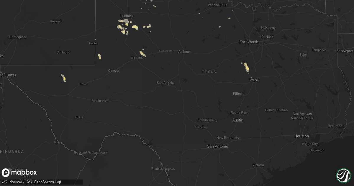
Hail Map in Texas on June 22, 2014
Get this storm
June 22 map
$229
one time, instant access
Download today. No call, no setup
Keep the $229
Bought the map and want the full workflow? Apply the entire $229 to a subscription within 7 days. None of it is wasted.
Every map, not just this one
This buys you this map. Subscription and you get every map we run, in the markets you choose from a few cities to whole states to nationwide. Plus real-time alerts the moment a storm fires.
Contact data
Name, contact info, occupancy, even credit band for addresses in the footprint. You go from where it hit to who to call.
Become the source they trust
Unlimited branding weather history reports on demand. You already have the documented answer ready for the property owner, and you are the one who showed up with it.
Property data and RoofTrace estimates
Pull up any address you have got, its value and the exact code rules for that jurisdiction, straight from One Click Code. Then RoofTrace estimates the squares, pitch, and roof value, priced the way you price.
Storm reports in Texas
Texas
| Date | Description |
|---|---|
| 06/22/20146:57 PM CDT | Storm chasers reported a tornado on the ground with a center pivot irrigation system flipped and damaged. Tornado was rated ef-0...and lasted 6 minutes. |
| 06/22/20146:20 PM CDT | 10-12 inch in diameter tree fell through a fence and on to a house. |
| 06/22/20146:15 PM CDT | Kact asos reported 59 mph at 611 pm. |
| 06/22/20146:15 PM CDT | Numerous trees down along flat rock road on the north side of lake waco |
| 06/22/20146:08 PM CDT | Several trees down on highway 185 just west of lake waco |
| 06/22/20144:58 PM CDT | 70 to 80 mph wind gusts at mccowan valley park |
| 06/22/20146:45 AM CDT | 5-6 inch diameter limb of elm tree down |
| 06/22/20146:21 AM CDT | 4-5 inch diameter tree down and 4-5 inch limb down in keller |
| 06/22/20146:20 AM CDT | Large tree blown down onto home in the 3800 block of 1st street in fort worth. Estimated 60 mph winds. |
| 06/22/20144:25 AM CDT | Powerlines down |
| 06/22/20144:15 AM CDT | Measured at kickapoo airport /kcwc/. Spotters report trees down in wichita falls. |
| 06/22/20143:55 AM CDT | Large tree down. Sondra dr off of callfield. Via kfdx |
| 06/22/20143:45 AM CDT | Large tree down. Public report via kfdx |
| 06/22/20143:30 AM CDT | Detected by the west texas mesonet |
| 06/22/20142:51 AM CDT | West texas mesonet observation |
| 06/22/20142:33 AM CDT | Observed by the west texas mesonet. Another 60 mph wind gust also occurred at 235 am. |
| 06/22/20142:15 AM CDT | A local report indicates 60 MPH wind near GOODLETT |
| 06/22/20141:50 AM CDT | Sampled by the west texas mesonet |
| 06/22/20141:05 AM CDT | Recorded by the west texas mesonet |
| 06/22/20141:00 AM CDT | Measured by the west texas mesonet |
| 06/22/201412:30 AM CDT | A local report indicates 60 MPH wind near 2 WSW CLARENDON |
| 06/22/201412:19 AM CDT | A local report indicates 59 MPH wind near 10 ENE PALO DURO CANYON |
| 06/22/201412:10 AM CDT | A local report indicates 60 MPH wind near 1 ENE MCLEAN |
| 06/22/201412:05 AM CDT | A local report indicates 61 MPH wind near 3 NW PALO DURO CANYON |
| 06/22/201412:04 AM CDT | A local report indicates 61 MPH wind near 3 NNW PALO DURO CANYON |
| 06/21/201411:47 PM CDT | A local report indicates 59 MPH wind near 7 SW PANTEX |
| 06/21/201411:47 PM CDT | A local report indicates 60 MPH wind near 5 WNW TIMBERCREEK CANYO |
| 06/21/201411:46 PM CDT | A local report indicates 67 MPH wind near 6 ENE AMARILLO |
| 06/21/201411:46 PM CDT | A local report indicates 64 MPH wind near 4 NNW LAKE TANGLEWOOD |
| 06/21/201411:45 PM CDT | A local report indicates 58 MPH wind near 4 NNW LAKE TANGLEWOOD |
| 06/21/201411:40 PM CDT | A local report indicates 68 MPH wind near 2 ESE PAMPA |
| 06/21/201411:39 PM CDT | A local report indicates 59 MPH wind near 6 NW TIMBERCREEK CANYON |
| 06/21/201411:38 PM CDT | Roof blown off a carport and a large tree blown down. Damage on the north side of amarillo. |
| 06/21/201411:38 PM CDT | A local report indicates 61 MPH wind near 5 SSW AMARILLO |
| 06/21/201411:38 PM CDT | Roof blown off a carport and a large tree blown down. Damage on the north side of amarillo. |
| 06/21/201411:38 PM CDT | A local report indicates 59 MPH wind near 9 NNE AMARILLO |
| 06/21/201411:36 PM CDT | A local report indicates 70 MPH wind near 5 W TIMBERCREEK CANYON |
| 06/21/201411:35 PM CDT | Couple of homes damaged. Time estimated based on radar. |
| 06/21/201411:35 PM CDT | A local report indicates 58 MPH wind near 9 NNE AMARILLO |
| 06/21/201411:35 PM CDT | A local report indicates 64 MPH wind near 2 ESE PAMPA |
| 06/21/201411:30 PM CDT | A local report indicates 70 MPH wind near 6 NNW AMARILLO |
| 06/21/201411:28 PM CDT | Winds estimated at 65 to 70 mph. Power out across town. |
| 06/21/201411:25 PM CDT | Large trees down in pampa |
| 06/21/201411:25 PM CDT | Widespread straight line wind damage in pampa including trees and powerlines down...power outages...and at least one house fire caused by the storms |
| 06/21/201411:25 PM CDT | Sustained 73 mph wind with a gust to 93 mph. |
| 06/21/201411:11 PM CDT | Winds estimated at 60 to 70 mph |
| 06/21/201410:48 PM CDT | A local report indicates 61 MPH wind near 26 NW MIAMI |
| 06/21/201410:40 PM CDT | A local report indicates 80 MPH wind near 15 SW WOLF CREEK PARK |
| 06/21/201410:32 PM CDT | A local report indicates 80 MPH wind near 18 SSE SPEARMAN |
| 06/21/201410:15 PM CDT | A local report indicates 60 MPH wind near 2 SW CANADIAN |
| 06/21/201410:12 PM CDT | A local report indicates 1.00 inch wind near CANADIAN |
| 06/21/201410:02 PM CDT | Hail from nickel size up to quarter size was reported. |
| 06/21/20149:45 PM CDT | Damage reported on red deer creek road to a farmstead and several barns. Nws amarillo is currently awaiting results from a storm survey to officially rate this tornado. |
| 06/21/20149:42 PM CDT | Very strong winds as well |
| 06/21/20149:40 PM CDT | A local report indicates 70 MPH wind near 6 WNW CANADIAN |
| 06/21/20148:55 PM CDT | Golf ball size hail and estimated 50 mph winds at intersection of us hwy 83 and state hwy 23 |
| 06/21/20148:46 PM CDT | High winds also. |
| 06/21/20147:22 PM CDT | Storm chasers reported a brief tornado touchdown. Tornado was rated ef-0...and lasted 1 minute. |
| 06/21/20147:18 PM CDT | A local report indicates 1.00 inch wind near 2 E BOOKER |
| 06/21/20147:08 PM CDT | A local report indicates 2.50 inch wind near DARROUZETT |
| 06/21/20147:05 PM CDT | A local report indicates 1.75 inch wind near DARROUZETT |
All States Impacted by Hail Map on June 22, 2014
Cities Impacted by Hail Map on June 22, 2014
- High Springs, FL
- Licking, MO
- Claude, TX
- Macon, MS
- Louisville, MS
- Stinnett, TX
- Spearman, TX
- Perryton, TX
- Borger, TX
- Pampa, TX
- Miami, TX
- Englewood, KS
- Pierce, CO
- Briggsdale, CO
- Wellington, CO
- Nunn, CO
- Ault, CO
- Carr, CO
- Canadian, TX
- Victoria, KS
- Walker, KS
- Gorham, KS
- Oskaloosa, IA
- Eddyville, IA
- Fremont, IA
- Beacon, IA
- Cedar, IA
- Wakefield, KS
- Milford, KS
- New Castle, VA
- King City, MO
- McFall, MO
- Topeka, KS
- Rossville, KS
- Delia, KS
- Silver Lake, KS
- Sheridan Lake, CO
- Maywood, NE
- Hayes Center, NE
- Keosauqua, IA
- Douds, IA
- Milton, IA
- Hoisington, KS
- Olmitz, KS
- Roggen, CO
- Wauneta, NE
- Flagler, CO
- Laverne, OK
- Waynesboro, MS
- Otis, CO
- Perryville, MO
- Elmore, AL
- Wetumpka, AL
- Thermopolis, WY
- Worland, WY
- Jacksonville, MO
- Cairo, MO
- Batesville, MS
- Princeton, MO
- Kellyville, OK
- Yuma, CO
- Post, TX
- Wheeler, TX
- Mobeetie, TX
- Shamrock, TX
- Tulia, TX
- Montgomery, AL
- Beaver, OK
- Kit Carson, CO
- Ulysses, KS
- Johnson, KS
- Saint Charles, MO
- O'Fallon, MO
- Saint Peters, MO
- Brownell, KS
- Bazine, KS
- Blountsville, AL
- Garden City, KS
- Satanta, KS
- Deerfield, KS
- Lakin, KS
- Karval, CO
- Union, IA
- Albion, IA
- Liscomb, IA
- Thomasville, AL
- Bonne Terre, MO
- Floyd, NM
- Defuniak Springs, FL
- Canton, KS
- Pueblo, CO
- Indianola, MS
- Leoti, KS
- Russell, KS
- Oneonta, AL
- Lesterville, MO
- Redford, MO
- Nashville, GA
- Wappapello, MO
- Greenville, MO
- Pachuta, MS
- Vossburg, MS
- Tescott, KS
- Wiggins, CO
- Log Lane Village, CO
- Orchard, CO
- Weldona, CO
- Fort Morgan, CO
- Elbert, CO
- Marienthal, KS
- Canyon, TX
- Walterboro, SC
- Balko, OK
- Gate, OK
- Crosbyton, TX
- Brookfield, MO
- Selmer, TN
- Bethel Springs, TN
- Ness City, KS
- Panhandle, TX
- Groom, TX
- Clarendon, TX
- Amarillo, TX
- Tahoka, TX
- Benton, MS
- Scott City, KS
- Hartley, TX
- Dalhart, TX
- Ellinwood, KS
- Great Bend, KS
- Dighton, KS
- Bird City, KS
- Holyoke, CO
- Nazareth, TX
- Happy, TX
- Dimmitt, TX
- Empire, AL
- Yates City, IL
- Gilson, IL
- Maquon, IL
- Winona, KS
- Wallace, KS
- Alexander, KS
- Nekoma, KS
- Decatur, IA
- Leon, IA
- Davis City, IA
- Lyons, KS
- Memphis, MO
- Ensign, KS
- Minneola, KS
- Dodge City, KS
- Cimarron, KS
- Wolfforth, TX
- Meadow, TX
- Ropesville, TX
- Wilson, TX
- Lubbock, TX
- Riley, KS
- Fort Riley, KS
- Junction City, KS
- Overton, NE
- Sumner, NE
- Lexington, NE
- Hilliard, FL
- Yoder, CO
- Ordway, CO
- Olney Springs, CO
- White Deer, TX
- Meade, KS
- Forgan, OK
- Sharon Springs, KS
- Owasso, OK
- Tulsa, OK
- Booker, TX
- Follett, TX
- Darrouzett, TX
- Lapine, AL
- Highland Home, AL
- Letohatchee, AL
- Fort Deposit, AL
- Newton, KS
- North Newton, KS
- Farber, MO
- Laddonia, MO
- Minneapolis, KS
- Delphos, KS
- Akron, CO
- Washington, IA
- Lenox, GA
- White City, KS
- Kilmichael, MS
- Fort Collins, CO
- Brownfield, TX
- Salt Flat, TX
- Holly, CO
- Syracuse, KS
- Rogers, NM
- Portales, NM
- Alma, KS
- Skellytown, TX
- Lovilia, IA
- Keenesburg, CO
- Coldwater, KS
- Protection, KS
- Kress, TX
- Silverton, TX
- Warsaw, MO
- Edson, KS
- Rea, MO
- Union Star, MO
- Brush, CO
- Hardesty, OK
- Guymon, OK
- Gruver, TX
- Copeland, KS
- Sublette, KS
- Blackshear, GA
- Alma, GA
- Garrett, WY
- Bell, FL
- Little York, IL
- Monmouth, IL
- Couch, MO
- Myrtle, MO
- Autaugaville, AL
- Marion, KS
- Lincolnville, KS
- Kanorado, KS
- Goodland, KS
- Van Buren, MO
- Maple Hill, KS
- Atchison, KS
- Rushville, MO
- De Kalb, MO
- Harper, IA
- South English, IA
- Keota, IA
- Webster, IA
- North English, IA
- Deep River, IA
- Rush Center, KS
- Greenville, AL
- Sunray, TX
- Manzanola, CO
- Laurel, MS
- Spearville, KS
- Bowman, SC
- Odonnell, TX
- Holcomb, KS
- Ethel, MO
- Browning, MO
- New Boston, MO
- Winigan, MO
- Green City, MO
- Green Castle, MO
- Elmer, MO
- Milan, MO
- Bucklin, MO
- Avondale, CO
- Wright, KS
- Rosston, OK
- Highland, KS
- Oregon, MO
- Morgan, TX
- Clifton, TX
- Blum, TX
- Whitney, TX
- Eaton, CO
- Little River, KS
- Windom, KS
- Pawnee Rock, KS
- Eskridge, KS
- Harveyville, KS
- Geneseo, KS
- Lorraine, KS
- Holyrood, KS
- Bushton, KS
- Healy, KS
- Ottumwa, IA
- University Park, IA
- Kirkville, IA
- Kellogg, IA
- Grinnell, IA
- Medicine Bow, WY
- Monticello, FL
- Paulding, MS
- Pfeifer, KS
- Bison, KS
- Bryson, TX
- Jermyn, TX
- Folsom, NM
- Salisbury, MO
- Haxtun, CO
- Ray City, GA
- Otis, KS
- Robinson, KS
- Troy, KS
- Everest, KS
- North Platte, NE
- Sutherland, NE
- Hershey, NE
- Saint Francis, KS
- Mize, MS
- Enterprise, MS
- Powhattan, KS
- Hiawatha, KS
- Fairview, KS
- Netawaka, KS
- Wetmore, KS
- Tuskegee, AL
- Salina, KS
- Assaria, KS
- Gypsum, KS
- Weston, MO
- Platte City, MO
- Wentzville, MO
- Hugo, CO
- Birmingham, IA
- Fairfield, IA
- Wathena, KS
- Ramer, AL
- Hillsboro, KS
- Lehigh, KS
- Boone, CO
- Sugar City, CO
- Wellfleet, NE
- Tribune, KS
- Versailles, MO
- Florence, MO
- Livingston, AL
- Gravois Mills, MO
- Lancaster, KS
- Yukon, OK
- State Center, IA
- Alta Vista, KS
- Carrollton, MO
- Roswell, NM
- Ocala, FL
- Anthony, FL
- Newton, IA
- Hugoton, KS
- Champion, NE
- Amherst, CO
- Irondale, MO
- Bismarck, MO
- Valdosta, GA
- Summerfield, FL
- Weirsdale, FL
- Dahinda, IL
- Williamsfield, IL
- Saint Joseph, MO
- Elwood, KS
- Claxton, GA
- Lakeland, GA
- Tallassee, AL
- Cainsville, MO
- Bennett, CO
- Jeffrey City, WY
- Leland, MS
- Vaiden, MS
- Winona, MS
- Higgins, TX
- Hull, IL
- Allen, KS
- New Cambria, MO
- Salem, MO
- Elida, NM
- Byhalia, MS
- Montezuma, KS
- Melrose, IA
- Russell, IA
- Coahoma, TX
- Dexter, NM
- Amazonia, MO
- Wellborn, FL
- Saint George, SC
- Round O, SC
- Whitewater, KS
- Oakwood, OK
- Oxford, MS
- Grove Hill, AL
- Olive Branch, MS
- Alva, OK
- Pattonsburg, MO
- Eldon, IA
- Batavia, IA
- Elmwood, IL
- Foristell, MO
- Ashburn, GA
- Sycamore, GA
- Lawtey, FL
- Starke, FL
- Effingham, KS
- Nicholls, GA
- Coffeeville, AL
- Brooklyn, IA
- Malcom, IA
- Osceola, MO
- Ocilla, GA
- Weir, MS
- Lockney, TX
- Tie Siding, WY
- Claflin, KS
- Ashland, KS
- Saint Patrick, MO
- Kinsley, KS
- Ford, KS
- Offerle, KS
- Ransom, KS
- Guernsey, IA
- Victor, IA
- Honoraville, AL
- Idalia, CO
- Seymour, TX
- Kanopolis, KS
- Lake City, FL
- Herington, KS
- Peoria, IL
- Mapleton, IL
- Pekin, IL
- Manito, IL
- Vaughan, MS
- Hereford, TX
- Macomb, IL
- Ellsworth, KS
- Chariton, IA
- Ridgeland, MS
- Madison, MS
- Doddsville, MS
- Osceola, AR
- Council Grove, KS
- Burdick, KS
- Lost Springs, KS
- Ramona, KS
- Patterson, GA
- Mershon, GA
- Fowler, KS
- Wayside, TX
- Gainesville, FL
- Glasford, IL
- Andrews, TX
- Manhattan, KS
- Sylvester, GA
- Albany, GA
- Floydada, TX
- Earle, AR
- Monroe City, MO
- Philadelphia, MO
- Emden, MO
- Wayland, MO
- Kahoka, MO
- Emporia, KS
- Shaw, MS
- York, AL
- Lewistown, MO
- Macon, MO
- Justiceburg, TX
- Benoit, MS
- Meridian, MS
- Stonewall, MS
- Ingalls, KS
- Leary, GA
- Newton, GA
- Middletown, MO
- Fruitland Park, FL
- Oakley, KS
- Madison, MO
- Bendena, KS
- Denton, KS
- Agency, IA
- Vancleave, MS
- Snyder, CO
- Alapaha, GA
- Marlow, OK
- White Cloud, KS
- Whiting, KS
- Forest City, MO
- Sabetha, KS
- Harleyville, SC
- Selma, AL
- Puxico, MO
- Tillatoba, MS
- Fowler, CO
- Mandeville, LA
- Flomot, TX
- Matador, TX
- Courtland, MS
- Hobart, OK
- Sentinel, OK
- Solomon, KS
- Bennington, KS
- Frankford, MO
- McDonald, KS
- Marked Tree, AR
- Illinois City, IL
- Saltillo, MS
- Arriba, CO
- Windsor, MO
- Calhoun, MO
- Fitzpatrick, AL
- Douglas, WY
- Philadelphia, MS
- Sanderson, FL
- Lone Wolf, OK
- Limon, CO
- Briscoe, TX
- La Prairie, IL
- Clayton, IL
- Camp Point, IL
- Golden, IL
- Yalaha, FL
- Dubois, WY
- Buckatunna, MS
- Ashford, AL
- Dothan, AL
- Goessel, KS
- Calhan, CO
- Davis, OK
- Blythedale, MO
- Riverton, WY
- Cambridge, IA
- Emelle, AL
- New Cambria, KS
- Libertyville, IA
- Buffalo, OK
- Bowie, TX
- Cottageville, SC
- Wyaconda, MO
- Temple, OK
- Columbia, AL
- Vincent, AL
- Harpersville, AL
- Sterrett, AL
- Alpine, AL
- The Villages, FL
- Grinnell, KS
- Trivoli, IL
- Brimfield, IL
- Farmington, IL
- Canton, IL
- Windsor, CO
- Hanna City, IL
- Red Wing, MN
- Goodhue, MN
- Noxapater, MS
- Kopperl, TX
- Sumner, GA
- De Valls Bluff, AR
- Roe, AR
- Clarendon, AR
- Miami, MO
- Rose Hill, IA
- What Cheer, IA
- Alexis, IL
- Cole Camp, MO
- Big Spring, TX
- Seminole, TX
- Greeley, CO
- Dwight, KS
- Easton, KS
- Moundridge, KS
- Durham, KS
- Las Animas, CO
- Table Grove, IL
- Rocky Ford, CO
- Bunceton, MO
- Glen Elder, KS
- Beloit, KS
- Marion, AL
- Wilson, AR
- Bentonia, MS
- Bowling Green, MO
- Louisiana, MO
- Bunker Hill, KS
- Luray, KS
- Mayetta, KS
- Eureka, MO
- Pacific, MO
- Peabody, KS
- Bamberg, SC
- Repton, AL
- Center, MO
- Bloomfield, IA
- Hastings, FL
- Palatka, FL
- East Palatka, FL
- Beggs, OK
- Ellington, MO
- Shubuta, MS
- Pierceville, KS
- Nahunta, GA
- Horton, KS
- Hooker, OK
- Slaton, TX
- Vulcan, MO
- Mclean, TX
- Walters, OK
- Westbrook, TX
- Tyler, AL
- Electra, TX
- Notasulga, AL
- Eclectic, AL
- Admire, KS
- Hedrick, IA
- Alachua, FL
- Vinita, OK
- Cope, CO
- Bethel, MO
- Holly Hill, SC
- Apache, OK
- Fort Cobb, OK
- Parkin, AR
- Chiefland, FL
- San Jon, NM
- La Crosse, KS
- Brady, NE
- Farnam, NE
- Collinsville, MS
- Lindsborg, KS
- Mathews, AL
- Valley Mills, TX
- Youngstown, FL
- Albert, KS
- Ethel, MS
- Saint Simons Island, GA
- Steinhatchee, FL
- Topeka, IL
- Marquette, KS
- Mcpherson, KS
- Andalusia, AL
- Anabel, MO
- Clarence, MO
- Magee, MS
- Mount Olive, MS
- Stover, MO
- Mora, MO
- Shoshoni, WY
- Piedmont, MO
- Bellevue, TX
- Lepanto, AR
- Dyess, AR
- Arbela, MO
- Crawfordsville, IA
- Ainsworth, IA
- Bethany, MO
- Savannah, MO
- Darlington, MO
- Rosendale, MO
- Coffey, MO
- Dozier, AL
- Catoosa, OK
- Claremore, OK
- Ewing, MO
- Burlingame, KS
- Rose Hill, MS
- Raymond, KS
- New Canton, IL
- Kinderhook, IL
- Ocklawaha, FL
- Ridgeway, MO
- Curryville, MO
- Fulton, MS
- Huntsville, MO
- Ramah, CO
- Strasburg, CO
- Mediapolis, IA
- Sperry, IA
- Stewartsville, MO
- Lovington, NM
- Drakesville, IA
- Palisade, NE
- Patterson, MO
- Red Level, AL
- Opa Locka, FL
- Miami, FL
- Alexandria, MO
- Ellsinore, MO
- Cement, OK
- Alford, FL
- Mooreville, MS
- Glenallen, MO
- Steele, AL
- Gallant, AL
- Altoona, AL
- Hannibal, MO
- Belzoni, MS
- Green Cove Springs, FL
- Rhodes, IA
- Collins, IA
- Mount Orab, OH
- De Witt, MO
- Boulder, CO
- Trenton, NE
- Newhall, IA
- Van Horne, IA
- Hays, KS
- Pike Road, AL
- Warwick, GA
- Melrose, NM
- Floris, IA
- Genoa, CO
- Liverpool, IL
- Verona, IL
- Kinsman, IL
- Ollie, IA
- Avon, IL
- Oquawka, IL
- Livermore, CO
- Morrill, KS
- Vega, TX
- Comanche, OK
- Vandalia, MO
- Eddyville, NE
- Altha, FL
- Lake Saint Louis, MO
- Kingsland, GA
- Woodbine, GA
- Collinsville, OK
- Chickasha, OK
- Foxworth, MS
- Dawson, GA
- Lacombe, LA
- Osborn, MO
- Wilsey, KS
- Hesston, KS
- Halstead, KS
- Freeport, FL
- Plainview, TX
- Mooreland, OK
- Seiling, OK
- Burdett, KS
- Larned, KS
- Kim, CO
- Newark, MO
- La Belle, MO
- Bassfield, MS
- Eads, CO
- Gorin, MO
- Ladora, IA
- Keswick, IA
- Millersburg, IA
- Adel, GA
- Fort Gaines, GA
- Hart, TX
- Burlington, IA
- Bunnell, FL
- Hoboken, GA
- Waycross, GA
- Belleview, MO
- Ironton, MO
- Plymouth, IL
- Plains, KS
- Curtis, NE
- Joiner, AR
- Selma, IA
- Ackerman, MS
- Edwards, MO
- Lincoln, MO
- Elm Creek, NE
- Smoaks, SC
- Wewahitchka, FL
- Chase, KS
- Cheyenne Wells, CO
- Dearborn, MO
- Faucett, MO
- Merritt, NC
- Oologah, OK
- Bosworth, MO
- Sardis, MS
- Roaring Springs, TX
- McCracken, KS
- Old Town, FL
- Durham, MO
- Moravia, IA
- Lincoln, KS
- Beverly, KS
- Canton, MS
- Hardy, AR
- Fountain, FL
- Crenshaw, MS
- Fort White, FL
- Grandfield, OK
- Jay, FL
- Century, FL
- Slidell, LA
- Waco, TX
- Panama City, FL
- Newberry, FL
- New London, MO
- Auburn, KS
- Laramie, WY
- Graham, TX
- Gladstone, IL
- Snyder, TX
- Leavenworth, KS
- Walton, KS
- Lewistown, IL
- Cuba, IL
- Sweetwater, OK
- Muscotah, KS
- Webb, AL
- Cowarts, AL
- Melbourne, IA
- Fredericktown, MO
- Rush, CO
- Kersey, CO
- Lipscomb, TX
- Hanston, KS


