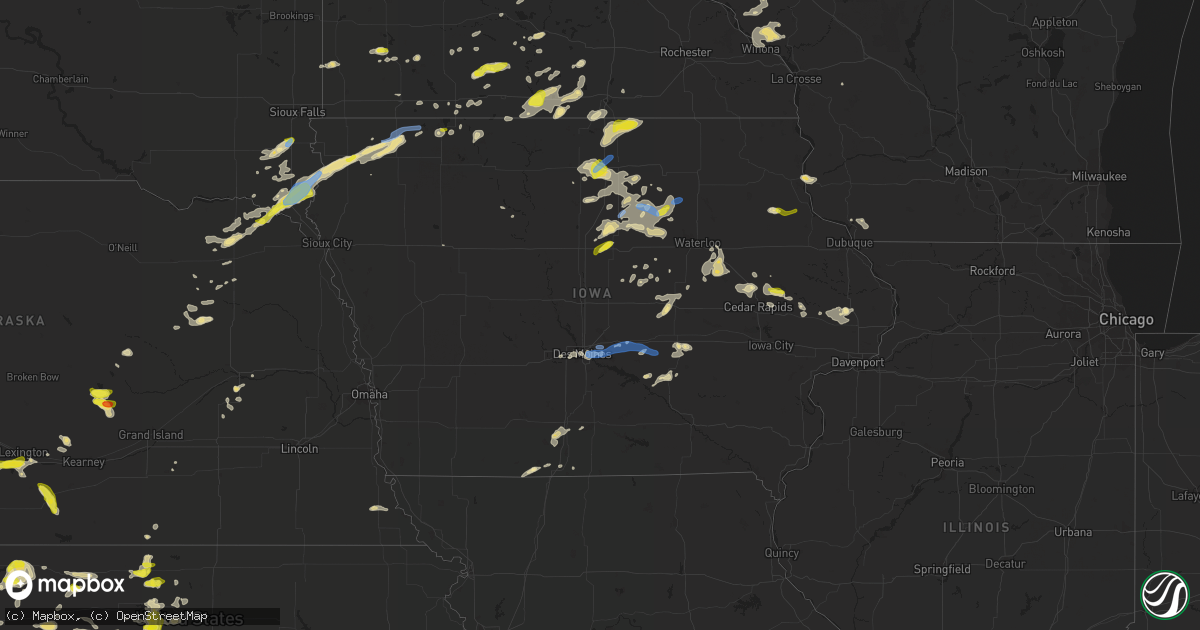
Hail Map in Iowa on June 21, 2020
Get this storm
June 21 map
$229
one time, instant access
Download today. No call, no setup
Keep the $229
Bought the map and want the full workflow? Apply the entire $229 to a subscription within 7 days. None of it is wasted.
Every map, not just this one
This buys you this map. Subscription and you get every map we run, in the markets you choose from a few cities to whole states to nationwide. Plus real-time alerts the moment a storm fires.
Contact data
Name, contact info, occupancy, even credit band for addresses in the footprint. You go from where it hit to who to call.
Become the source they trust
Unlimited branding weather history reports on demand. You already have the documented answer ready for the property owner, and you are the one who showed up with it.
Property data and RoofTrace estimates
Pull up any address you have got, its value and the exact code rules for that jurisdiction, straight from One Click Code. Then RoofTrace estimates the squares, pitch, and roof value, priced the way you price.
Storm reports in Iowa
Iowa
| Date | Description |
|---|---|
| 06/21/20206:56 PM CDT | A local report indicates 62 MPH wind near 3 NE CLEAR LAKE |
| 06/21/20206:54 PM CDT | Report from mping: quarter |
| 06/21/20205:30 PM CDT | Iowa dot reported that a large tree was down blocking both lanes of highway 30 where highway 30 crosses the wapsipinicon river east of wheatland. Time of the event was |
| 06/21/20205:20 PM CDT | Em reports a downed power pole and downed trees across town. Estimated gusts at 60 mph. |
| 06/21/20205:02 PM CDT | A few 4-5 inch diameter tree branches down. |
| 06/21/20204:43 PM CDT | Up to quarter sized hail. |
| 06/21/20204:42 PM CDT | Branches down in lake park... Reported by local law enforcement. |
| 06/21/20204:37 PM CDT | Numerous 4 to 10 inches tree branches downed by straight line winds. |
| 06/21/20204:35 PM CDT | 50-60 mph gusts reported. |
| 06/21/20204:16 PM CDT | A local report indicates 62 MPH wind near 2 N SHELDON |
| 06/21/20204:15 PM CDT | Power pole and trees down. |
| 06/21/20203:59 PM CDT | Trees down from straight line winds. |
| 06/21/20203:55 PM CDT | Hail from dime size to quarter size. |
| 06/21/20203:48 PM CDT | 6 to 9 inch diameter tree branch down... Power outages in rock valley. |
| 06/21/20203:25 PM CDT | . |
| 06/21/20203:24 PM CDT | Spiked hail stone that is roughly quarter sized. One spike measured 1.2 inches in diameter. |
| 06/21/20203:02 PM CDT | Corrects previous hail report to correct the time from 1 wnw lafayette. Spiked hail stone that is roughly quarter sized. One spike measured 1.2 inches in diameter. |
| 06/21/20201:25 PM CDT | Corn crop damaged. Corn laying down in spots... And some leaves stripped. |
| 06/21/20201:25 PM CDT | A local report indicates 1.00 inch wind near 2 N MOUNT AUBURN |
| 06/21/20204:14 AM CDT | At 914 PM CDT, a severe thunderstorm was located near Aplington, or 9 miles southwest of Allison, moving east at 30 mph. HAZARD...60 mph wind gusts and nickel size hail. SOURCE...Radar indicated. IMPACT...Expect damage to roofs, siding, and trees. Locations impacted include... Waverly, Allison, Parkersburg, Shell Rock, Aplington, Janesville, New Hartford and Waverly Municipal Airport. |
| 06/21/20203:56 AM CDT | At 856 PM CDT, a severe thunderstorm was located near Tripoli, or 10 miles northeast of Waverly, moving east at 30 mph. HAZARD...60 mph wind gusts. SOURCE...Radar indicated. IMPACT...Expect damage to roofs, siding, and trees. Locations impacted include... Waverly, Sumner and Tripoli. |
| 06/21/20203:30 AM CDT | At 829 PM CDT, a severe thunderstorm was located 7 miles north of Iowa Falls, moving northeast at 35 mph. HAZARD...60 mph wind gusts and quarter size hail. SOURCE...Radar indicated. IMPACT...Hail damage to vehicles is expected. Expect wind damage to roofs, siding, and trees. Emergency management reports numerous instances of 60 to 70 mph winds with these storms and trees and powerlines down. Locations impacted include... Iowa Falls, Hampton, Allison, Ackley, Clarksville, Shell Rock, Greene, Aplington, Dumont, Plainfield, Frederika, Geneva, Bristow, Bradford, Hansell, Aredale, Hampton Municipal Airport, Allison Municipal Airport and Ackley Municipal Airport. |
| 06/21/20203:08 AM CDT | At 807 PM CDT, a severe thunderstorm was located over Allison, moving northeast at 25 mph. HAZARD...60 mph wind gusts and quarter size hail. SOURCE...Radar indicated. IMPACT...Hail damage to vehicles is expected. Expect wind damage to roofs, siding, and trees. Locations impacted include... Allison, Ackley, Clarksville, Dumont, Plainfield, Frederika, Bristow and Allison Municipal Airport. |
| 06/21/20202:55 AM CDT | At 755 PM CDT, a severe thunderstorm was located near Iowa Falls, moving northeast at 30 mph. HAZARD...60 mph wind gusts and quarter size hail. SOURCE...Radar indicated. IMPACT...Hail damage to vehicles is expected. Expect wind damage to roofs, siding, and trees. Locations impacted include... Iowa Falls, Ackley, Alden, Buckeye, Owasa and Iowa Falls Municipal Airport. |
| 06/21/20202:38 AM CDT | At 738 PM CDT, a severe thunderstorm was located over Hampton, moving northeast at 35 mph. HAZARD...60 mph wind gusts and quarter size hail. SOURCE...Radar indicated. IMPACT...Hail damage to vehicles is expected. Expect wind damage to roofs, siding, and trees. Locations impacted include... Hampton, Greene, Dumont, Coulter, Geneva, Bristow, Bradford, Hansell, Chapin, Aredale, Hampton Municipal Airport and Beeds Lake State Park. |
| 06/21/20202:21 AM CDT | At 721 PM CDT, a severe thunderstorm was located near Rockwell, or 9 miles southwest of Mason City, moving east at 25 mph. HAZARD...60 mph wind gusts and quarter size hail. SOURCE...Radar indicated. IMPACT...Hail damage to vehicles is expected. Expect wind damage to roofs, siding, and trees. Locations impacted include... Mason City, Rockwell, Swaledale, Burchinal and Portland. This includes Interstate 35 between mile markers 182 and 192. |
| 06/21/20202:14 AM CDT | At 714 PM CDT, severe thunderstorms were located along a line extending from St. Ansgar to Nora Springs, moving east at 30 mph. HAZARD...60 mph wind gusts and penny size hail. SOURCE...Radar indicated. IMPACT...Expect damage to roofs, siding, and trees. Severe thunderstorms will be near... St. Ansgar around 720 PM CDT. Osage around 725 PM CDT. Floyd around 740 PM CDT.Other locations impacted by these severe thunderstorms include CountyRoads A 39 And S 70, Rock Creek, Idlewilde State Park, Howardville,Brownville, County Roads T 54 And A 31 and County Roads B 20 And T26. |
| 06/21/20202:02 AM CDT | Lamoni airport asos. |
| 06/21/20201:58 AM CDT | Wood frame of steel building blown down during the storm. 2.50 inches of rainfall also received. |
| 06/21/20201:52 AM CDT | Some tree damage from newton to reasnor. Other tree damage in eastern jasper county. From jasper co dispatch. Time estimated from radar. |
| 06/21/20201:30 AM CDT | Observation from personal weather station. As602 3 nnw pleasant hill. |
| 06/21/20201:29 AM CDT | At 629 AM CDT, a severe thunderstorm was located near Lawton, or 11 miles southeast of Sioux City, moving east at 20 mph. HAZARD...60 mph wind gusts and quarter size hail. SOURCE...Radar indicated. IMPACT...Hail damage to vehicles is expected. Expect wind damage to roofs, siding, and trees. This severe thunderstorm will be near... Moville around 650 AM CDT. Anthon around 700 AM CDT.Other locations impacted by this severe thunderstorm include Bronsonand Oto. |
| 06/21/20201:05 AM CDT | Tree down on road. Time estimated from radar. |
| 06/21/20201:05 AM CDT | Tree damage along e douglas. Time estimated from radar. |
| 06/21/20201:00 AM CDT | Idot reports wires and trees down along e 14th/highway 69. Tree blocking southbound lanes. Time estimated from radar. |
| 06/20/202011:55 PM CDT | At 455 PM CDT, a severe thunderstorm was located over Superior, or near Estherville, moving east at 40 mph. HAZARD...60 mph wind gusts and quarter size hail. SOURCE...Radar indicated. IMPACT...Hail damage to vehicles is expected. Expect wind damage to roofs, siding, and trees. Locations impacted include... Estherville, Okamanpedan Lake, Iowa Lake, Swan Lake, Ingham Lake, High Lake, Armstrong, Wallingford, Gruver, Dolliver, Fort Defiance State Park, Okamanpedan State Park, Wolden County Park and Estherville Municipal Airport. |
| 06/20/202011:53 PM CDT | At 453 PM CDT, severe thunderstorms were located along a line extending from 8 miles southwest of Lakefield to near Fostoria, moving east at 55 mph. HAZARD...60 mph wind gusts. SOURCE...Emergency management. At 442 pm a 59 mph wind was reported at 3 southeast of Lake Park. IMPACT...Expect damage to roofs, siding, and trees. Severe thunderstorms will be near... Terril around 505 PM CDT. Jackson In Jackson County around 510 PM CDT.Other locations impacted by these severe thunderstorms include Alpha. |
| 06/20/202011:22 PM CDT | At 422 PM CDT, severe thunderstorms were located along a line extending from near Little Rock to near Sibley to near Melvin, moving northeast at 50 mph. HAZARD...60 mph wind gusts and quarter size hail. SOURCE...Public. At 416 pm CDT a 62 mph wind gust was reported at Sheldon. IMPACT...Hail damage to vehicles is expected. Expect wind damage to roofs, siding, and trees. Severe thunderstorms will be near... Melvin around 425 PM CDT. Hartley around 430 PM CDT. Ocheyedan around 435 PM CDT. Harris around 440 PM CDT. Lake Park and Round Lake around 445 PM CDT. Milford, Arnolds Park, Okoboji, Wahpeton and West Okoboji around 455 PM CDT. Spirit Lake, Lakefield and Orleans around 500 PM CDT.Other locations impacted by these severe thunderstorms includeBigelow. |
| 06/20/202010:45 PM CDT | At 345 PM CDT, a severe thunderstorm was located over Whittier, or 9 miles west of Anamosa, moving east at 15 mph. HAZARD...60 mph wind gusts and quarter size hail. SOURCE...Radar indicated. IMPACT...Hail damage to vehicles is expected. Expect wind damage to roofs, siding, and trees. Locations impacted include... Anamosa, Springville, Waubeek, Langworthy, Stone City, Whittier, Viola, Matsell Bridge Natural Area and Wapsipinicon State Park. |
| 06/20/20209:53 PM CDT | At 253 PM CDT, a severe thunderstorm was located near Union Grove State Park, or 9 miles northeast of Vermillion, moving northeast at 30 mph. HAZARD...60 mph wind gusts and quarter size hail. SOURCE...Radar indicated. IMPACT...Hail damage to vehicles is expected. Expect wind damage to roofs, siding, and trees. This severe thunderstorm will be near... Akron around 310 PM CDT. Alcester around 320 PM CDT. Hawarden around 330 PM CDT.Other locations impacted by this severe thunderstorm includeChatsworth. |
| 06/20/20209:46 PM CDT | At 245 PM CDT, a severe thunderstorm was located near Volga, or near Elkader, moving northeast at 15 mph. HAZARD...Quarter size hail. SOURCE...Radar indicated. IMPACT...Damage to vehicles is expected. This severe thunderstorm will be near... Elkader around 315 PM CDT.Other locations impacted by this severe thunderstorm includeMederville, Garber, Motor, Communia, Clayton Center, St. Olaf. |
| 06/20/20209:41 PM CDT | At 241 PM CDT, a severe thunderstorm was located near Delmar, or 7 miles south of Maquoketa, moving southeast at 10 mph. HAZARD...60 mph wind gusts and quarter size hail. SOURCE...Radar indicated. IMPACT...Hail damage to vehicles is expected. Expect wind damage to roofs, siding, and trees. Locations impacted include... DeWitt, Delmar, Charlotte and Welton. |
| 06/20/20208:38 PM CDT | A local report indicates 60 MPH wind near PLAINFIELD |
| 06/20/20208:36 PM CDT | Report from mping of tree limbs broken. |
| 06/20/20208:21 PM CDT | At 119 PM CDT, a severe thunderstorm was located over Mount Auburn, or 7 miles north of Vinton, moving east at 15 mph. HAZARD...60 mph wind gusts and quarter size hail. SOURCE...Radar indicated. IMPACT...Hail damage to vehicles is expected. Expect wind damage to roofs, siding, and trees. Locations impacted include... Urbana, Brandon, Rowley, Mount Auburn, Lime Creek County Park, Spencers Grove, Minne Estema Park, Cheney and Vinton Memorial Airport.This includes Interstate 380 between mile markers 40 and 53. |
| 06/20/20208:10 PM CDT | Multiple tree limbs and power lines down in iowa falls. |
| 06/20/20207:45 PM CDT | A local report indicates 73 MPH wind near HAMPTON |
| 06/20/20207:40 PM CDT | Mixed in with a lot of smaller hail. Lasted roughly 10 minutes. |
| 06/20/20207:40 PM CDT | Tree limbs down west of hampton. Time and location estimated by radar. |
| 06/20/20207:20 PM CDT | Rwis site rmci4 south of mason city on interstate 35. |
| 06/20/20207:19 PM CDT | Report via social media. Location estimated by radar. |
All States Impacted by Hail Map on June 21, 2020
Cities Impacted by Hail Map on June 21, 2020
- Crofton, NE
- Fordyce, NE
- Bloomfield, NE
- Wausa, NE
- Hartington, NE
- Hill City, KS
- Mullinville, KS
- Greensburg, KS
- Dawson, AL
- Beresford, SD
- Centerville, SD
- Miami, TX
- Luray, KS
- Lucas, KS
- Childersburg, AL
- Alpine, AL
- Newnan, GA
- Sharpsburg, GA
- West, MS
- Tellico Plains, TN
- Loomis, NE
- Holdrege, NE
- Atlanta, NE
- Orleans, NE
- Bertrand, NE
- Paradise, KS
- Natoma, KS
- Lakin, KS
- Bayfield, WI
- Washburn, WI
- Roanoke, AL
- Wedowee, AL
- La Pointe, WI
- Meade, KS
- Van Wert, IA
- Murray, IA
- Grand River, IA
- Osceola, IA
- Amber, OK
- Slayton, MN
- Lake Wilson, MN
- Moscow, KS
- Carnegie, OK
- Henrietta, TX
- Wichita Falls, TX
- Albion, NE
- Petersburg, NE
- Melvin, IA
- Elk Point, SD
- Sheldon, IA
- Alcester, SD
- Sanborn, IA
- Burbank, SD
- George, IA
- Hudson, SD
- Ashton, IA
- Hawarden, IA
- Newcastle, NE
- Matlock, IA
- Wynot, NE
- Sibley, IA
- Ireton, IA
- Sioux Center, IA
- Rock Valley, IA
- Vermillion, SD
- Boyden, IA
- Hull, IA
- Greeley, NE
- Garden City, KS
- Lincoln, KS
- Sylvan Grove, KS
- Ocheyedan, IA
- Carter, OK
- Sentinel, OK
- Lone Wolf, OK
- Englewood, KS
- New Richmond, WI
- Plainville, KS
- Wilson, KS
- Hannibal, MO
- Palmyra, MO
- Utica, MS
- Natchitoches, LA
- Marathon, TX
- Maud, OK
- Bowlegs, OK
- Seminole, OK
- Junction City, AR
- Homer, LA
- Haynesville, LA
- Canadian, TX
- Crawford, OK
- Cheyenne, OK
- Reydon, OK
- Durham, OK
- Glen Elder, KS
- Beloit, KS
- Aline, OK
- Carmen, OK
- Waynoka, OK
- Lebanon, KS
- Mankato, KS
- Esbon, KS
- Burr Oak, KS
- Cimarron, KS
- Plains, KS
- Duluth, MN
- Mobeetie, TX
- Perryton, TX
- Guide Rock, NE
- Bastrop, LA
- Montezuma, IA
- Toddville, IA
- Center Point, IA
- Shipman, IL
- Gillespie, IL
- Holyrood, KS
- Bushton, KS
- Claflin, KS
- Litchfield, IL
- Green Forest, AR
- Berryville, AR
- Loris, SC
- Belzoni, MS
- Willis, TX
- New Waverly, TX
- Wright, KS
- Jetmore, KS
- Dodge City, KS
- Edwards, MS
- Balko, OK
- Gove, KS
- Grinnell, KS
- Winona, KS
- Oakley, KS
- Odin, MN
- Eudora, AR
- Oak Grove, LA
- Russell, KS
- Bunker Hill, KS
- Dorrance, KS
- Lorraine, KS
- Hoisington, KS
- Butternut, WI
- Hayward, WI
- Potosi, WI
- Stockton, KS
- Jasper, AL
- Cordova, AL
- Townley, AL
- Parrish, AL
- Oakman, AL
- Platteville, WI
- Oregon, MO
- Kellerton, IA
- Mount Ayr, IA
- Spickard, MO
- Trenton, MO
- St John, KS
- Jonesboro, LA
- Chatham, LA
- Wheeler, TX
- Briscoe, TX
- Iowa Falls, IA
- Bradford, IA
- Alden, IA
- Hampton, IA
- Auburn, NE
- Nemaha, NE
- Humboldt, NE
- Hempstead, TX
- Waller, TX
- Prairie View, TX
- Prairie Du Chien, WI
- McGregor, IA
- New Ulm, MN
- Rising City, NE
- Shelby, NE
- Huntsville, TX
- Ellsworth, KS
- Raymond, OH
- Marysville, OH
- Patriot, OH
- Lineville, AL
- Ledbetter, TX
- Westbrook, MN
- Ada, OK
- Asher, OK
- Wanette, OK
- Stratford, OK
- Byars, OK
- Clear Lake, IA
- Satanta, KS
- Chester, OK
- Ringwood, OK
- Carrier, OK
- Goltry, OK
- Cleo Springs, OK
- Liberal, KS
- Enid, OK
- Gate, OK
- Freedom, OK
- Meno, OK
- Mooreland, OK
- Kismet, KS
- Lahoma, OK
- Rosston, OK
- Helena, OK
- Alva, OK
- Buffalo, OK
- Dacoma, OK
- Chetek, WI
- Dallas, WI
- Cameron, WI
- Barron, WI
- Elmore, MN
- Ruleville, MS
- Gillette, WY
- Healy, KS
- Dighton, KS
- Apache, OK
- Spearman, TX
- Tillar, AR
- Rohwer, AR
- Watson, AR
- Hugoton, KS
- Ulysses, KS
- Wynnewood, OK
- Pauls Valley, OK
- Atkinson, IL
- McCamey, TX
- Ingalls, KS
- Eighty Four, PA
- Washington, PA
- Scenery Hill, PA
- Tribune, KS
- Morehead, KY
- Fargo, OK
- Bowie, TX
- Hamburg, AR
- Benoit, MS
- Sweetwater, OK
- Elk City, OK
- Dill City, OK
- Sayre, OK
- Butler, OK
- Canute, OK
- Erick, OK
- Hennessey, OK
- Ames, OK
- Pierceville, KS
- Rockville, NE
- Stromsburg, NE
- Chenoa, IL
- Pontiac, IL
- Cragford, AL
- Hunter, KS
- Tipton, KS
- Transylvania, LA
- Mayersville, MS
- Bingham Lake, MN
- Mountain Lake, MN
- Jasper, MN
- Pipestone, MN
- Edgerton, MN
- Lake Providence, LA
- Lost Nation, IA
- Hampton, AR
- Brookston, TX
- Sumner, TX
- New Richland, MN
- Mitchellville, IA
- Runnells, IA
- Alexander, IA
- Belmond, IA
- Blanchard, OK
- Tuttle, OK
- Preston, MS
- De Kalb, MS
- Lawton, OK
- Cache, OK
- Faxon, OK
- Hope, AR
- Eros, LA
- Arcadia, FL
- Wells, MN
- Blue Earth, MN
- Sublette, KS
- Montezuma, KS
- Copeland, KS
- Bellwood, NE
- Mound Bayou, MS
- Hermitage, AR
- Elmer, LA
- Boyce, LA
- Malcom, IA
- Iowa Park, TX
- Loveland, OK
- Grandfield, OK
- Chattanooga, OK
- Indiahoma, OK
- Turon, KS
- Stafford, KS
- Harris, IA
- Lake Park, IA
- Appleton City, MO
- Warren, AR
- Harrisonburg, LA
- Woodville, MS
- Cardington, OH
- Birchwood, WI
- Mikana, WI
- Rice Lake, WI
- Mount Auburn, IA
- Woodward, OK
- El Reno, OK
- Anadarko, OK
- Dawsonville, GA
- Coldwater, KS
- Strawberry Point, IA
- Avon Park, FL
- Batesland, SD
- Tama, IA
- Montour, IA
- Wadsworth, OH
- Saginaw, MN
- Fort Pierre, SD
- Draper, SD
- Hayes, SD
- Murdo, SD
- Mankato, MN
- Lake Crystal, MN
- Lake Lure, NC
- Leesville, LA
- Marshalltown, IA
- Liscomb, IA
- Hoxie, KS
- Bunker Hill, IL
- Fort Stockton, TX
- Fort Supply, OK
- Devol, OK
- Burkburnett, TX
- Walters, OK
- Beaver, OK
- Binger, OK
- Hinton, OK
- Cedartown, GA
- Glenville, MN
- Northwood, IA
- Emmons, MN
- Lake Mills, IA
- Monument, KS
- Laverne, OK
- Cornucopia, WI
- Brookville, KS
- Irene, SD
- Wakonda, SD
- Anamosa, IA
- Marion, IA
- Martelle, IA
- Central City, IA
- Alburnett, IA
- Springville, IA
- Alderson, WV
- Richland, MS
- Pearl, MS
- Flowood, MS
- Jackson, MS
- Bloomfield, KY
- Springfield, KY
- Willisburg, KY
- Double Springs, AL
- Addison, AL
- Houston, AL
- Fulton, AR
- Dodge, WI
- Winona, MN
- Galesville, WI
- Fountain City, WI
- Trempealeau, WI
- Arcadia, WI
- Huntsville, AR
- Arnett, OK
- Fairmont, MN
- Armstrong, IA
- Weir, MS
- Ackerman, MS
- Boyceville, WI
- Clear Lake, WI
- Downing, WI
- Prairie Farm, WI
- Drew, MS
- Jewell, KS
- Broken Bow, OK
- Fordoche, LA
- Strong, AR
- Huttig, AR
- De Witt, AR
- Ethel, AR
- Superior, NE
- Lenora, KS
- Almena, KS
- Norton, KS
- Quincy, IL
- Taylor, MO
- Saint Peter, MN
- Lafayette, MN
- Osseo, WI
- Dahlonega, GA
- Havre, MT
- Fall Creek, WI
- Shattuck, OK
- Randolph, NE
- Eleva, WI
- Strum, WI
- Coats, KS
- Monroe, LA
- Clayton, LA
- Greene, IA
- Allison, IA
- Dumont, IA
- Bristow, IA
- Gorham, KS
- Grundy Center, IA
- Temple, OK
- Winchester, TN
- La Porte City, IA
- Worthington, MN
- Round Lake, MN
- Atlanta, LA
- Montgomery, LA
- Waldorf, MN
- Waseca, MN
- Garwin, IA
- Gilman, IA
- Toledo, IA
- Clutier, IA
- Beverly, KS
- Barnard, KS
- Fort Cobb, OK
- Decatur, TX
- Carthage, MS
- College Station, TX
- Saint James, MN
- Glade, KS
- Waldo, KS
- Gilmore City, IA
- Rolfe, IA
- Bellevue, TX
- Nocona, TX
- Greenville, MS
- Brady, NE
- Saint Ansgar, IA
- Kensett, IA
- Belpre, KS
- Macksville, KS
- Sharon, OK
- Mineral Springs, AR
- Monticello, AR
- Camden, AR
- Brackettville, TX
- Iron River, WI
- Brule, WI
- Port Wing, WI
- Maple, WI
- Mountain View, OK
- Amherst, NE
- Schoenchen, KS
- McCracken, KS
- Hays, KS
- Scottsboro, AL
- Grant, AL
- Bagley, WI
- Ormsby, MN
- Lewisville, MN
- Trimont, MN
- Conrad, IA
- Konawa, OK
- Saint Charles, AR
- Eveleth, MN
- Gilbert, MN
- Ridgeland, WI
- Albert Lea, MN
- Hollandale, MN
- Paint Rock, AL
- Trenton, AL
- El Dorado, AR
- Karnack, TX
- Colfax, WI
- Jackson, MN
- Osmond, NE
- Mclean, NE
- La Grange, MO
- Maywood, MO
- Haviland, KS
- Protection, KS
- Oakhurst, TX
- Booker, TX
- Forgan, OK
- Vici, OK
- Isabella, MN
- Parkersburg, IA
- New Prague, MN
- Caddo, OK
- Minneola, KS
- Hartland, MN
- Scott City, KS
- Marienthal, KS
- Leoti, KS
- Victoria, KS
- Dubach, LA
- Carmine, TX
- Kirwin, KS
- Eldridge, AL
- Carbon Hill, AL
- Minco, OK
- Union City, OK
- Rayville, LA
- Oak Ridge, LA
- Horatio, AR
- Pawnee Rock, KS
- Mechanicsville, IA
- Olin, IA
- Kennan, WI
- Catawba, WI
- Vinton, IA
- Brandon, IA
- Waterloo, IA
- Dysart, IA
- Jesup, IA
- Bogue, KS
- Damar, KS
- Palco, KS
- Great Bend, KS
- Angola, LA
- Saint Francisville, LA
- Newton, IA
- Madison, GA
- Lexa, AR
- Poplar Grove, AR
- Cuba City, WI
- Columbus, NE
- Montague, TX
- Palo, IA
- Warrior, AL
- Hayden, AL
- Cottage Hills, IL
- East Alton, IL
- Opelika, AL
- Lafayette, AL
- Waverly, AL
- Pioneer, LA
- Frostproof, FL
- Selden, KS
- Suches, GA
- Rockford, AL
- Kellyton, AL
- Alexander City, AL
- Elwood, NE
- Eustis, NE
- Lexington, NE
- Snyder, OK
- Mountain Park, OK
- Rozel, KS
- Nekoma, KS
- Holcomb, KS
- Camargo, OK
- North Platte, NE
- Maxwell, NE
- Sheldon, WI
- Alma, NE
- Rosedale, MS
- Beulah, MS
- Gainesville, TX
- Valley View, TX
- Era, TX
- Muenster, TX
- Ethel, MS
- Kosciusko, MS
- Newellton, LA
- Jacksons Gap, AL
- Davis, SD
- Lennox, SD
- Alden, MN
- Bricelyn, MN
- Rogers, AR
- Garfield, AR
- Darrouzett, TX
- Follett, TX
- Viborg, SD
- Worthing, SD
- Custer City, OK
- Huntsville, IL
- Byers, TX
- Petrolia, TX
- Pineville, LA
- Dry Prong, LA
- Liebenthal, KS
- Mooers Forks, NY
- Ellenburg Depot, NY
- Dodson, LA
- Sikes, LA
- Loup City, NE
- Ashton, NE
- Shamrock, TX
- Higgins, TX
- Foss, OK
- Piedmont, AL
- Caldwell, TX
- Bryan, TX
- Galt, MO
- Clarendon, AR
- Duncan, MS
- Wilmar, AR
- Delmar, IA
- Grand Mound, IA
- Florien, LA
- Herbster, WI
- Estherville, IA
- Merigold, MS
- Marion, LA
- Hoyt Lakes, MN
- Aurora, MN
- Traer, IA
- Pratt, KS
- Emerson, AR
- Cable, WI
- Solon Springs, WI
- Drummond, WI
- Sterling, KS
- Sherman, TX
- Rolling Fork, MS
- Sondheimer, LA
- Thornton, IA
- Swaledale, IA
- Rockwell, IA
- Ventura, IA
- Garner, IA
- Silver City, MS
- Ogden, AR
- Ashdown, AR
- Ferriday, LA
- Geneseo, IL
- Agra, KS
- Gaylord, KS
- Kensington, KS
- Phillipsburg, KS
- Athol, KS
- Rockford, IA
- Dougherty, IA
- Early, IA
- Lucas, OH
- Cordell, OK
- Ryan, OK
- Redwood, MS
- Gotebo, OK
- Hobart, OK
- Winnebago, MN
- Hot Springs, SD
- Harrison, TN
- Ooltewah, TN
- Starkville, MS
- Tchula, MS
- Louise, MS
- Ravenna, NE
- Albert, KS
- Talladega, AL
- Lincoln, AL
- Ackley, IA
- Aplington, IA
- Geneva, IA
- Pella, IA
- Harpersville, AL
- Mustang, OK
- Dadeville, AL
- Brandon, MS
- Gordon, WI
- Shelby, MS
- Alpena, AR
- Ringgold, TX
- Ashley, OH
- Osborne, KS
- Blair, OK
- Roosevelt, OK
- Okoboji, IA
- Milford, IA
- Spirit Lake, IA
- Ensign, KS
- Fowler, KS
- Gillett, AR
- Stuttgart, AR
- Greenville, GA
- Taloga, OK
- Glen Flora, WI
- Hawkins, WI
- Hollandale, MS
- Star City, AR
- Grady, AR
- Lakefield, MN
- Scotia, NE
- Rison, AR
- Sadler, TX
- New Sharon, IA
- Leighton, IA
- Ashland, WI
- Lead Hill, AR
- Morland, KS
- Colmesneil, TX
- Augusta, WI
- Lookeba, OK
- Hollister, OK
- Randlett, OK
- Electra, TX
- Sheppard Afb, TX
- Frederick, OK
- Forestburg, TX
- Alvord, TX
- Brimson, MN
- Neligh, NE
- Albion, IA
- Kodak, TN
- Weatherford, OK
- Corn, OK
- Waurika, OK
- Comfrey, MN
- Harvard, NE
- Sebring, FL
- Pierce, NE
- Smithfield, NE
- Mathiston, MS
- Marquette, IA
- Parkdale, AR
- Portland, AR
- Stapleton, NE
- Seiling, OK
- Gayville, SD
- La Crosse, KS
- Larned, KS
- Cochrane, WI
- Alma, WI
- Gilman, WI
- Hanston, KS
- Eupora, MS
- Cashton, WI
- Waukee, IA
- West Des Moines, IA
- Clinton, OK
- Leedey, OK
- Arapaho, OK
- Cleveland, TX
- Sully, IA
- Anguilla, MS
- Big Sandy, MT
- Trout, LA
- Olla, LA
- Uvalde, TX
- Madison, NE
- Newman Grove, NE
- Meadow Grove, NE
- Trafford, AL
- Red Cloud, NE
- Groveton, TX
- Coldspring, TX
- Sheffield, IA
- Lagrange, GA
- Timewell, IL
- Pine Mountain, GA
- Alexandria, LA
- Box Elder, MT
- Stanwood, IA
- Ashland, AL
- Valley Park, MS
- Miller, NE
- Antlers, OK
- Des Moines, IA
- Clayton, OK
- Daisy, OK
- Gridley, IL
- Princeton, MO
- Gracemont, OK
- Colfax, LA
- Tilden, NE
- Sterlington, LA
- Katy, TX
- Houston, TX
- Clayton, IL
- New Providence, IA
- Cedar Rapids, IA
- Shellsburg, IA
- Ness City, KS
- Lexington, MS
- Saratoga, AR
- Rose Hill, VA
- Durant, MS
- Hockley, TX
- Colony, OK
- Hydro, OK
- Woodbury, GA
- Molena, GA
- Concord, GA
- Gay, GA
- Conroe, TX
- Medina, OH
- Reading, MN
- Millersburg, OH
- Baltic, OH
- Welcome, MN
- Stanford, KY
- Walker, IA
- Spearville, KS
- Empire, AL
- Conception Junction, MO
- Barnard, MO
- Maryville, MO
- Searsboro, IA
- Deep River, IA
- Guernsey, IA
- Brooklyn, IA
- Trinity, TX
- Pointblank, TX
- Beaman, IA
- Glenwood City, WI
- Somerset, WI
- Terril, IA
- Klemme, IA
- Stout, IA
- Aredale, IA
- New Hartford, IA
- Kesley, IA
- Mason City, IA
- Austinville, IA
- Meservey, IA
- Shell Rock, IA
- Clarksville, IA
- Dows, IA
- Popejoy, IA
- Latimer, IA
- Eldora, IA
- Mount Vernon, IA
- Seville, OH
- Byers, KS
- Bison, KS
- Pfeifer, KS
- Otis, KS
- Stella, MO
- West Monroe, LA
- Ruston, LA
- Choudrant, LA
- Waskom, TX
- Dunnell, MN
- Alpha, MN
- Sherburn, MN
- Holly Grove, AR
- Almyra, AR
- Whitesboro, TX
- Hurley, SD
- Sparkman, AR
- Alligator, MS
- Pickens, MS
- Lena, MS
- Jonesville, LA
- Alton, KS
- Woodston, KS
- Rush Center, KS
- Farnam, NE
- Sallis, MS
- Easton, MN
- Two Harbors, MN
- Loranger, LA
- Mondovi, WI
- Cunningham, KS
- Eufaula, OK
- Frost, MN
- Delavan, MN
- Granada, MN
- Union, IA
- Kinsley, KS
- Osceola, NE
- McCool, MS
- Glenmora, LA
- Mapleton, MN
- Minnesota Lake, MN
- Windsor Heights, IA
- Guntersville, AL
- Columbia, LA
- Battle Creek, NE
- Lisbon, OH
- Elgin, OK
- Fletcher, OK
- Wayne, OK
- Centerburg, OH
- Sunbury, OH
- Croton, OH
- Bell Buckle, TN
- Shelbyville, TN
- De Valls Bluff, AR
- Buffalo Center, IA
- Ratcliff, AR
- Woodville, TX
- Glidden, WI
- Warm Springs, GA
- Manchester, GA
- Cruger, MS
- Enon Valley, PA
- New Castle, PA
- Stanberry, MO
- Sheridan, MO
- Roe, AR
- Fort Necessity, LA
- Gladbrook, IA
- Colfax, IA
- Hermanville, MS
- Deerfield, KS
- Saline, LA
- Brighton, IL
- Macon, MS
- Shuqualak, MS
- Avoca, MN
- Penokee, KS
- De Queen, AR
- Ragland, AL
- Ashville, AL
- Trent, SD
- Kanawha, IA
- Gurley, AL
- Auburn, NH
- White Castle, LA
- Carville, LA
- Goodwater, AL
- Good Thunder, MN
- Woodburn, IA
- Trenton, IL
- Lebanon, IL
- Mascoutah, IL
- Elgin, NE
- Campobello, SC
- Inman, SC
- Independence, WI
- Sanger, TX
- Sturgis, MS
- Creighton, NE
- Coleridge, NE
- Lamoni, IA
- Ravenwood, MO
- Dumas, AR
- Monterey, LA
- Rufe, OK
- Farmerville, LA
- Arnolds Park, IA
- Carlisle, IA
- Altoona, IA
- Pleasant Hill, IA
- Maitland, MO
- Natchez, LA
- Butterfield, MN
- Truman, MN
- Lexington, IL
- Rattan, OK
- Mellwood, AR
- Pheba, MS
- Boelus, NE
- Elm Creek, NE
- Burdett, KS
- Ashland, KS
- Flanagan, IL
- Lipscomb, TX
- Waukomis, OK
- Fairview, OK
- Amboy, MN
- Hanlontown, IA
- Carpenter, IA
- Manly, IA
- Terry, MT
- Wilton, AR
- Twin Lakes, MN
- Madelia, MN
- Tony, WI
- Lexington, OK
- Marvell, AR
- Morristown, TN
- Fulda, MN
- Harrison, AR
- Dunbar, WV
- Charleston, WV
- Nitro, WV
- Poca, WV
- Louisville, MS
- Pelahatchie, MS
- Prairie View, KS
- Logan, KS
- Rocky, OK
- Crocketts Bluff, AR
- Dallas, GA
- Philadelphia, MS
- Darfur, MN
- Sleepy Eye, MN
- Waynesboro, GA
- Martin, SC
- Volga, IA
- Mulberry, TN
- Belvidere, TN
- Somerville, TX
- Wheatland, IA
- Lowden, IA
- Calamus, IA
- Killduff, IA
- Reasnor, IA
- Marble Rock, IA
- Rainsville, AL
- Perrysville, OH
- Clarence, IA
- Leon, IA
- Ringold, OK
- Valliant, OK
- Brooksville, MS
- Carrollton, AL
- Crossett, AR
- Hospers, IA
- Decatur, IA
- Davis City, IA
- Lockesburg, AR
- Shaw, MS
- Reinbeck, IA
- Murphy, NC
- Milan, MO
- Boaz, AL
- Livingston, TX
- Plaquemine, LA
- Montrose, AR
- Indianola, MS
- Wallingford, IA
- Wilmot, AR
- Rome, OH
- Winfield, WV
- Red House, WV
- Talbott, TN
- Greer, SC
- Greenville, SC
- Avon, IL
- Sylacauga, AL
- Overton, NE
- Swainsboro, GA
- Wheeler, WI
- Hudson, KS
- Hastings, OK
- Superior, IA
- Russellville, TN
- Jefferson City, TN
- Sneedville, TN
- Eidson, TN
- Thorn Hill, TN
- Mooresburg, TN
- Rogersville, TN
- Sylvia, KS
- Iuka, KS
- Haven, KS
- Murdock, KS
- Arlington, KS
- Pretty Prairie, KS
- Cheney, KS
- Kingman, KS
- Wilmore, KS
- Waverly, IA
- Plainfield, IA
- Monroe, IA
- Grinnell, IA
- Lynnville, IA
- Prairie City, IA
- Hammon, OK
- Rosston, TX
- Saint Jo, TX
- Sunset, TX
- Terral, OK
- Stamps, AR
- Elkader, IA
- Elkport, IA
- Edgewood, IA
- Garber, IA
- Williams, IA
- Radcliffe, IA
- Gage, OK
- May, OK
- Watonga, OK
- Canton, OK
- Oakwood, OK
- Fay, OK
- Putnam, OK
- Bessie, OK
- Pocasset, OK
- Roff, OK
- Dougherty, OK
- Healdton, OK
- Lone Grove, OK
- Lindsay, OK
- Mannsville, OK
- Duncan, OK
- Burneyville, OK
- Lindsay, TX
- Ratliff City, OK
- Ardmore, OK
- Ringling, OK
- Marietta, OK
- Thackerville, OK
- Leon, OK
- Paoli, OK
- Foster, OK
- Graham, OK
- Madill, OK
- Davis, OK
- Kingston, OK
- Maysville, OK
- Tussy, OK
- Loco, OK
- Overbrook, OK
- Wilson, OK
- Lebanon, OK
- Purcell, OK
- Elmore City, OK
- Hennepin, OK
- Springer, OK
- Mill Creek, OK
- Sulphur, OK
- Lindale, GA
- Ashland, OH
- Mansfield, OH
- Grainfield, KS
- Wellford, SC
- Lyman, SC
- Duncan, SC


