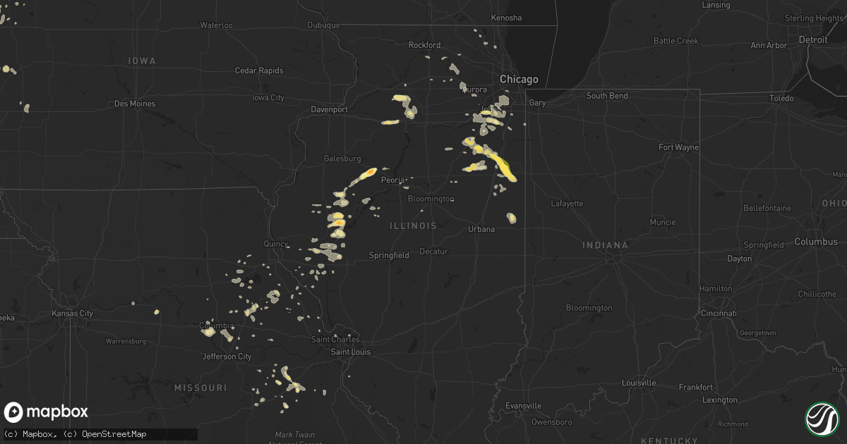
Hail Map in Illinois on June 21, 2014
Get this storm
June 21 map
$229
one time, instant access
Download today. No call, no setup
Keep the $229
Bought the map and want the full workflow? Apply the entire $229 to a subscription within 7 days. None of it is wasted.
Every map, not just this one
This buys you this map. Subscription and you get every map we run, in the markets you choose from a few cities to whole states to nationwide. Plus real-time alerts the moment a storm fires.
Contact data
Name, contact info, occupancy, even credit band for addresses in the footprint. You go from where it hit to who to call.
Become the source they trust
Unlimited branding weather history reports on demand. You already have the documented answer ready for the property owner, and you are the one who showed up with it.
Property data and RoofTrace estimates
Pull up any address you have got, its value and the exact code rules for that jurisdiction, straight from One Click Code. Then RoofTrace estimates the squares, pitch, and roof value, priced the way you price.
Storm reports in Illinois
Illinois
| Date | Description |
|---|---|
| 06/21/20146:57 PM CDT | Two trees... One 20 inch diameter... One 10 inch diameter blown down. Multiple tree limbs blown down. |
| 06/21/20146:42 PM CDT | A local report indicates 64 MPH wind near VERMILION COUNTY AIRPOR |
| 06/21/20146:42 PM CDT | Large tree down at liberty lane and ferndale. Tree blocking road. |
| 06/21/20146:42 PM CDT | Numerous reports of trees down on power poles or across roads from bismarck to danville. |
| 06/21/20146:35 PM CDT | At ld 25 |
| 06/21/20146:19 PM CDT | At caton farm rd and il59. Minor flooding. |
| 06/21/20145:37 PM CDT | In volo - gazebo lifted from backyard - droppped into front yard onto a gas regulator. Gilmer rd south of il120. Relayed to lake cnty 911. |
| 06/21/20145:34 PM CDT | Tree down - split roof of house - pheasant run rd nw of fairfield. Time estimated. |
| 06/21/20145:30 PM CDT | Relayed via facebook. |
| 06/21/20145:15 PM CDT | Sheriffs office has received several reports of trees and power lines down across town. |
| 06/21/20144:51 PM CDT | Near fremont center 50 to 60 mph winds with numerous 3 inches branches down. |
| 06/21/20144:50 PM CDT | Trees down. Numerous power poles downed along u.s. Highway 24. Also extensive damage done to one end of a warehouse building and small damage to a second farm building. |
| 06/21/20144:50 PM CDT | A local report indicates 75 MPH wind near MUNDELEIN |
| 06/21/20144:47 PM CDT | A local report indicates 70 MPH wind near HAWTHORN WOODS |
| 06/21/20144:45 PM CDT | Extensive damage to crops near town that appeared to be caused by large hail and/or large hail and severe winds based on photos. Time estimated per radar. |
| 06/21/20144:35 PM CDT | A local report indicates 1.00 inch wind near 1 S VERSAILLES |
| 06/21/20144:30 PM CDT | Possible tornado on the ground with a number of trees down. On the western edge of round lake beach. |
| 06/21/20144:30 PM CDT | 4 to 6 inch dia limbs |
| 06/21/20144:25 PM CDT | Large tree split and laying across the road |
| 06/21/20144:20 PM CDT | In town - numerous trees and power/utility lines down. 2 miles south of town a shed was demolished. |
| 06/21/20144:01 PM CDT | A local report indicates 70 MPH wind near 4 NE BURTON |
| 06/21/20144:00 PM CDT | A local report indicates 67 MPH wind near 4 NE BURTON |
| 06/21/20143:52 PM CDT | Large trees were blown down in new holland. |
| 06/21/20143:48 PM CDT | Large tree down on power lines - 1 block south of il115 on main st. Few utility poles and small branches down throughout the village. Time estimated from radar. |
| 06/21/20143:43 PM CDT | Tree blown down on highway 136 near san jose...relayed through sheriffs office. |
| 06/21/20143:39 PM CDT | Power lines blown down in mason city...relayed through sheriffs office. |
| 06/21/20143:35 PM CDT | Power lines blown down in mason city...relayed through sheriffs office. |
| 06/21/20143:30 PM CDT | Large tree down... Destroying a motorhome. Report via facebook |
| 06/21/20143:26 PM CDT | A local report indicates 1.75 inch wind near ASTORIA |
| 06/21/20143:20 PM CDT | Lots of penny and nickel-sized hail falling along us-24 beween astoria and 3 w astoria...largest hail stones measured 1.2 inches in diameter. |
| 06/21/20143:20 PM CDT | Power lines down blown in forest city. |
| 06/21/20143:18 PM CDT | A local report indicates 1.00 inch wind near ASTORIA |
| 06/21/20143:06 PM CDT | Power lines down in town of browning |
| 06/21/20143:02 PM CDT | A local report indicates 1.00 inch wind near RAY |
| 06/21/20142:48 PM CDT | Pea size hail. |
| 06/21/20142:45 PM CDT | Healthy trees up to 12 inches in diameter were blown over on the southeast side of elmwood. |
| 06/21/20142:45 PM CDT | A local report indicates 1.75 inch wind near 2 N ELMWOOD |
| 06/21/20142:42 PM CDT | Numerous tree limbs down... Corn stalks blown down and broken in two |
| 06/21/20142:25 PM CDT | A local report indicates 1.00 inch wind near MARIETTA |
| 06/21/20141:50 PM CDT | At us52 and cedar rd - several small branches down. Also minor street flooding southward into wilton center. |
| 06/20/20147:18 PM CDT | Three trees down - 12-16 inches in diameter. |
| 06/20/20147:11 PM CDT | Wind gust to 50 mph - small tree limbs down |
| 06/20/20147:02 PM CDT | Three trees down - 12-16 inches in diameter. |
| 06/20/20147:00 PM CDT | Multiple large trees down - includes along many of the county roads. Tree on house at 620w county line rd. |
All States Impacted by Hail Map on June 21, 2014
Cities Impacted by Hail Map on June 21, 2014
- Newcastle, WY
- Upton, WY
- Osage, WY
- Cleghorn, IA
- Marcus, IA
- Beresford, SD
- Hudson, SD
- Sharon Springs, KS
- Elmwood, IL
- Gordon, NE
- Merriman, NE
- Arthur, NE
- Haigler, NE
- Midland, SD
- Valley City, ND
- Rogers, ND
- Luverne, ND
- Thompson, ND
- Reynolds, ND
- Bourbon, MO
- Sullivan, MO
- Mansfield, SD
- Crookston, MN
- Climax, MN
- Nielsville, MN
- Mentor, MN
- Beltrami, MN
- Columbia, MO
- Wooldridge, MO
- Jamestown, MO
- Faulkton, SD
- Onaka, SD
- Fort Pierre, SD
- Bethune, CO
- Stratton, CO
- Santa Rosa, NM
- Morrison, TN
- Manchester, TN
- Charleston, SC
- Charleston Afb, SC
- Littlefork, MN
- Big Falls, MN
- Eagle Butte, SD
- Timber Lake, SD
- Dix, NE
- Syracuse, KS
- Eastover, SC
- Marshall, MO
- Reddick, FL
- Williston, FL
- Hayes, SD
- Clifton, IL
- Ashkum, IL
- Crescent City, IL
- Milford, IL
- Watseka, IL
- Danforth, IL
- Gilman, IL
- Chebanse, IL
- Gerald, MO
- Leslie, MO
- Hill City, SD
- Lead, SD
- Roscoe, SD
- Laddonia, MO
- Martinsburg, MO
- Montpelier, ND
- Greeley, CO
- Platteville, CO
- Kersey, CO
- La Salle, CO
- Clio, AL
- Clopton, AL
- Clayton, AL
- Ansley, NE
- Arcadia, NE
- Mason City, NE
- Curtis, NE
- Arlington, TN
- Eads, TN
- Eureka, SD
- Hosmer, SD
- Vona, CO
- Kirk, CO
- Wagon Mound, NM
- Barry, IL
- New Canton, IL
- Dillon, SC
- Latta, SC
- Ashley, ND
- Fingal, ND
- Allen, SD
- Wanblee, SD
- Cheyenne Wells, CO
- Gillette, WY
- Irene, SD
- Freeman, SD
- Viborg, SD
- Danville, IL
- Potomac, IL
- Wingina, VA
- Appomattox, VA
- Pamplin, VA
- Buckingham, VA
- Dillwyn, VA
- Prospect, VA
- Gladstone, VA
- Farmville, VA
- Burlington, CO
- Pine Ridge, SD
- Felton, MN
- Conway, SC
- Rockham, SD
- Redfield, SD
- Alapaha, GA
- Weskan, KS
- Montgomery City, MO
- Section, AL
- Ypsilanti, ND
- Jamestown, ND
- Willacoochee, GA
- Broken Bow, NE
- Westerville, NE
- Jonesboro, AR
- State University, AR
- La Moille, IL
- Arlington, IL
- Malden, IL
- Ohio, IL
- Princeton, IL
- Parks, NE
- Quincy, IL
- Liberty, IL
- Shipman, VA
- Pearson, GA
- Autryville, NC
- Charter Oak, IA
- Dunlap, IA
- Dow City, IA
- Arapahoe, NE
- Edison, NE
- Elwood, NE
- Bertrand, NE
- Litchfield, NE
- Ord, NE
- Oconto, NE
- Rush Hill, MO
- Tecumseh, MO
- Dora, MO
- Middletown, MO
- Tribune, KS
- Blanchard, ND
- Hunter, ND
- Caledonia, ND
- Galesburg, ND
- Hillsboro, ND
- Cummings, ND
- Oriska, ND
- Page, ND
- Shelly, MN
- Java, SD
- Bowdle, SD
- Cullom, IL
- Fairbury, IL
- Piper City, IL
- Chatsworth, IL
- Saunemin, IL
- Forrest, IL
- Los Alamos, NM
- Hitchcock, SD
- Aurelia, IA
- Cherokee, IA
- Georgetown, SC
- Nemo, SD
- Rapid City, SD
- Custer, SD
- Keystone, SD
- Deadwood, SD
- Beaver City, NE
- Callaway, NE
- Paris, MO
- Ipswich, SD
- Hurley, SD
- Wagarville, AL
- Marietta, IL
- Smithfield, IL
- University Park, IL
- Monee, IL
- Dupree, SD
- Mills, NE
- Gettysburg, SD
- Astoria, IL
- Rushville, IL
- Browning, IL
- Kissimmee, FL
- Selby, SD
- Wakpala, SD
- Mound City, SD
- Glenham, SD
- Goose Creek, SC
- Spiritwood, ND
- Sanborn, ND
- Volin, SD
- Lebanon, SD
- Frankfort, IL
- Dalton, GA
- Wayne, NE
- Frostproof, FL
- Sheridan, WY
- Cherry Creek, SD
- Bishopville, SC
- Greensboro, AL
- Vernon, FL
- Gardner, ND
- Anthon, IA
- Hornick, IA
- Oto, IA
- Moville, IA
- Bennett, CO
- Silex, MO
- Troy, MO
- Hoven, SD
- Tolstoy, SD
- Ashton, SD
- Cresbard, SD
- Mobridge, SD
- Northville, SD
- New London, MO
- Wauconda, IL
- Grayslake, IL
- Round Lake, IL
- Mundelein, IL
- Eufaula, AL
- Arion, IA
- Bronson, IA
- Smithland, IA
- Climbing Hill, IA
- Willow Lake, SD
- Farmington, IL
- Yates City, IL
- Brimfield, IL
- Dalzell, SC
- Sumter, SC
- Kulm, ND
- Edgeley, ND
- Campbell, MO
- Holcomb, MO
- Clarkton, MO
- Ranchester, WY
- Parkman, WY
- Dayton, WY
- Florence, SC
- Darlington, SC
- Monterey, TN
- Crossville, TN
- Vaughn, NM
- Joes, CO
- McLean, IL
- Loman, MN
- Birch Tree, MO
- Loris, SC
- Fulton, MO
- Chadron, NE
- Fort Sumner, NM
- Saint James, MO
- Alta, IA
- Menno, SD
- Utica, SD
- Benton City, MO
- Coal City, IL
- Mazon, IL
- Oxford, NE
- Joliet, IL
- Channahon, IL
- Primrose, NE
- Albion, NE
- Seymour, MO
- New Lenox, IL
- New Raymer, CO
- McIntosh, AL
- Shelbina, MO
- Indianola, NE
- Mitchell, NE
- Atkinson, NE
- Table Grove, IL
- Ipava, IL
- Dwight, IL
- Stapleton, NE
- Ute, IA
- Soldier, IA
- Mapleton, IA
- Hampton, GA
- Locust Grove, GA
- Mcdonough, GA
- Albertville, AL
- Mitchell, SD
- Mount Vernon, SD
- Saint Cloud, FL
- Pilger, NE
- Wisner, NE
- Chapin, IL
- Keenesburg, CO
- Hudson, CO
- Loup City, NE
- Emden, MO
- Monroe City, MO
- Geddes, SD
- Northwood, ND
- Arapahoe, CO
- Ponca, NE
- Elk Point, SD
- Culbertson, NE
- Harlan, IA
- Avoca, IA
- Stuart, NE
- Naper, NE
- Newport, NE
- Fredonia, ND
- Lehr, ND
- Lugoff, SC
- Nakina, NC
- Spencer, NE
- White Owl, SD
- Madison, MO
- Holliday, MO
- Rocheport, MO
- Caputa, SD
- Hermosa, SD
- Le Mars, IA
- Steelville, MO
- Jacksonville, NC
- Holly Ridge, NC
- Kanorado, KS
- Albany, GA
- Bassett, NE
- Gainesboro, TN
- Pleasant Hill, IL
- Forbes, ND
- Forest City, IL
- Topeka, IL
- Havana, IL
- Eads, CO
- Sheridan Lake, CO
- Strasburg, ND
- Pollock, SD
- Gothenburg, NE
- Arnold, NE
- Brady, NE
- Fairburn, GA
- Palmetto, GA
- McCook, NE
- Wardell, MO
- Hayti, MO
- Bragg City, MO
- Manhattan, IL
- Sacramento, NM
- Mexico, MO
- Jud, ND
- Wray, CO
- Amboy, IL
- Harmon, IL
- Wellsville, MO
- Adams, ND
- Valentine, NE
- Hubert, NC
- Cordele, GA
- Branford, FL
- Cross, SC
- Pollocksville, NC
- Maysville, NC
- Coosada, AL
- Deatsville, AL
- Millbrook, AL
- Elmore, AL
- Minneota, MN
- Taunton, MN
- Humboldt, TN
- Medina, TN
- Trenton, TN
- Emington, IL
- Campus, IL
- Cabery, IL
- Reddick, IL
- Gardner, IL
- Herscher, IL
- Union Hill, IL
- Kankakee, IL
- Buckingham, IL
- Youngstown, FL
- Chipley, FL
- Piedmont, AL
- Centre, AL
- Sublette, IL
- Pocahontas, AR
- Ravenden Springs, AR
- Oak Lawn, IL
- Kimball, NE
- Moorefield, NE
- Belvidere, SD
- Newcastle, NE
- Burbank, SD
- Plainfield, IL
- Mountain View, AR
- Wakonda, SD
- Norton, KS
- Havana, FL
- Alcester, SD
- Brunsville, IA
- Fairview, IL
- Sturgis, SD
- Ridgely, TN
- Whitesburg, GA
- Newnan, GA
- Huger, SC
- Orleans, NE
- Avon, IL
- Bushnell, IL
- Dunning, NE
- Frederick, IL
- Rosebud, MO
- Cuba, MO
- Clarendon, NC
- Tabor City, NC
- Chadbourn, NC
- Whiteville, NC
- Douglasville, GA
- Atlanta, GA
- Castana, IA
- Rodney, IA
- Ashland, MO
- New Bloomfield, MO
- Nebo, IL
- Winona, MO
- Vermillion, SD
- Fullerton, ND
- Remsen, IA
- Hinton, IA
- Washta, IA
- Pierson, IA
- Kingsley, IA
- Quimby, IA
- International Falls, MN
- Sweetwater, TN
- Philadelphia, TN
- Madisonville, TN
- Senatobia, MS
- Goodland, KS
- Watkins, CO
- Palm Bay, FL
- Axson, GA
- Douglas, GA
- Rossville, IL
- Howard, SD
- Luray, SC
- Valdosta, GA
- Lake Park, GA
- Morton, IL
- Birchwood, TN
- Greenwood Springs, MS
- Des Moines, NM
- Oshkosh, NE
- Bowling Green, MO
- Covington, LA
- Bush, LA
- Elloree, SC
- Cuba, IL
- Plains, GA
- Americus, GA
- Tallahassee, FL
- Crawfordville, FL
- Odell, IL
- Rockport, IL
- Greenville, NC
- Butte, NE
- York, AL
- Lenox, GA
- Belle, MO
- Vichy, MO
- Quincy, FL
- Cambridge, NE
- Sylvester, GA
- Rozet, WY
- Winner, SD
- Ideal, SD
- Owensville, MO
- Wallace, NE
- Dickens, NE
- Arabi, GA
- Dyersburg, TN
- Newbern, TN
- Curryville, MO
- Ogallala, NE
- Rebecca, GA
- Fitzgerald, GA
- Argusville, ND
- Arthur, ND
- Bainbridge, GA
- Attapulgus, GA
- Newville, AL
- Columbia, AL
- Headland, AL
- Vernon, CO
- Herreid, SD
- Presho, SD
- Raiford, FL
- Starke, FL
- Weed, NM
- Centerville, SD
- Champion, NE
- Imperial, NE
- Buffalo Gap, SD
- Vonore, TN
- Wallace, KS
- Spalding, NE
- Petersburg, NE
- Ayden, NC
- Scribner, NE
- Abbeville, AL
- Bland, MO
- Springville, TN
- Lawtey, FL
- Blountstown, FL
- Faith, SD
- Summerville, GA
- La Fayette, GA
- Wall, SD
- Leasburg, MO
- Greeley, NE
- Louisiana, MO
- Quitman, MS
- Shubuta, MS
- Melvin, AL
- Gilbertown, AL
- Saint Charles, MO
- Avon Park, FL
- Fordland, MO
- Timmonsville, SC
- Fort Meade, FL
- Wyanet, IL
- Buda, IL
- Sheffield, IL
- Elwood, IL
- Enders, NE
- Florissant, MO
- Somerset, KY
- Dover, NC
- Jamestown, SC
- Pontiac, IL
- Kempton, IL
- Eureka, IL
- Marshfield, MO
- Arenzville, IL
- Cedar Lake, IN
- Beecher, IL
- Meherrin, VA
- Oacoma, SD
- Orangeburg, SC
- Martin, TN
- Piedmont, SD
- Wilmington, IL
- Hahira, GA
- Cordesville, SC
- Bonneau, SC
- Versailles, IL
- Beardstown, IL
- Mount Sterling, IL
- Oakes, ND
- Piggott, AR
- Bristow, NE
- Glencross, SD
- Minooka, IL
- Shorewood, IL
- Morris, IL
- Peotone, IL
- Mescalero, NM
- Clayton, IL
- Chambersburg, IL
- Jacksonville, IL
- Meredosia, IL
- Bluffs, IL
- Baylis, IL
- Stoutsville, MO
- Perry, MO
- Stamford, NE
- Sulligent, AL
- Melbourne, FL
- Rockledge, FL
- Waverly, MO
- Crawford, NE
- Alton, MO
- Whitney, NE
- Melrose, NM
- Lake Zurich, IL
- Vernon Hills, IL
- Sugar Valley, GA
- Chiefland, FL
- Doniphan, MO
- Holstein, IA
- Gackle, ND
- Columbus, NE
- Adel, GA
- New Underwood, SD
- North Charleston, SC
- Moncks Corner, SC
- Hanahan, SC
- Rembert, SC
- Crossville, AL
- Coldwater, MS
- Moorhead, IA
- Lake Wales, FL
- East Dublin, GA
- Andover, SD
- Elgin, SC
- Ponce De Leon, FL
- Fork, SC
- Lake View, SC
- Sycamore, IL
- Maple Park, IL
- Moody, MO
- Hickory Hills, IL
- Bridgeview, IL
- Burbank, IL
- Justice, IL
- Long Valley, SD
- Pittsfield, IL
- Parker, CO
- Aurora, CO
- Dixon, IL
- Lawton, IA
- Wauneta, NE
- Rockingham, NC
- Agar, SD
- Ward, AL
- Enfield, NC
- Bell, FL
- Ranger, GA
- Merrill, IA
- Protem, MO
- Martin, SD
- O'Fallon, MO
- Hermann, MO
- Remer, MN
- Harriman, TN
- Louisville, AL
- Georgetown, MN
- Moorhead, MN
- Kingston, IL
- Easton, IL
- Linden, AL
- Glen Saint Mary, FL
- Camp Lejeune, NC
- Long Island, KS
- Anton Chico, NM
- Sisseton, SD
- Paris, TN
- Buchanan, TN
- Tinley Park, IL
- Homer Glen, IL
- Lockport, IL
- Mokena, IL
- Lemont, IL
- Palos Heights, IL
- Oak Forest, IL
- Palos Park, IL
- Orland Park, IL
- Axis, AL
- Geraldine, AL
- Groveoak, AL
- Agate, CO
- Groton, SD
- Smithville, GA
- Westfield, IA
- Higbee, MO
- Howes, SD
- Milesville, SD
- Thompson, MO
- Sioux City, IA
- Carthage, TN
- Pleasant Shade, TN
- Lamar, SC
- Long Lake, SD
- Bristol, FL
- Ayr, ND
- Amenia, ND
- Sparta, TN
- Meridian, MS
- Wedgefield, SC
- Ringwood, IL
- Richmond, IL
- Danbury, IA
- Potter, NE
- Monroe Center, IL
- Davis Junction, IL
- Ellendale, ND
- Hannibal, MO
- Gideon, MO
- Griggsville, IL
- Braidwood, IL
- Tebbetts, MO
- Hope, ND
- Interior, SD
- Scotland, SD
- Colchester, IL
- Macomb, IL
- Bronson, FL
- Colome, SD
- Arrowsmith, IL
- Idalia, CO
- Auxvasse, MO
- Vermont, IL
- Corning, AR
- Nunda, SD
- Jackson, AL
- Littleton, IL
- Industry, IL
- Oglethorpe, GA
- Hayes Center, NE
- Collison, IL
- Deer Creek, IL
- Climax, GA
- Canton, IL
- Lewistown, IL
- Liverpool, IL
- Vandalia, MO
- Atkinson, NC
- Black Hawk, SD
- Canton, SD
- Aynor, SC
- Clayton, NM
- North Loup, NE
- Fyffe, AL
- Dawson, AL
- London Mills, IL
- Maquon, IL
- Ellisville, IL
- Union Springs, AL
- Comstock, NE
- Society Hill, SC
- Clarksville, MO
- Monticello, KY
- Frankford, MO
- Blackstone, IL
- Cornell, IL
- Maywood, NE
- Ocilla, GA
- Steward, IL
- Oswego, IL
- Montgomery, IL
- Whitakers, NC
- Plymouth, IL
- Dekalb, IL
- Manteno, IL
- Madison, SD
- Hartsville, SC
- Buckley, IL
- Adair, IL
- Delaplaine, AR
- Nashville, TN
- Pegram, TN
- Kingston Springs, TN
- Granville, IA
- Camden, SC
- Panama City, FL
- Correctionville, IA
- Van Orin, IL
- Walnut, IL
- North Platte, NE
- Hookerton, NC
- Grifton, NC
- Ravenden, AR
- Hunnewell, MO
- Newton, GA
- Leary, GA
- Saint Matthews, SC
- Palmer, NE
- Decker, MT
- Marion, SC
- Mullins, SC
- Canby, MN
- Lomira, WI
- Grant Park, IL
- Platte, SD
- Pembroke Pines, FL
- Winfield, MO
- Foley, MO
- Larimore, ND
- Watertown, TN
- Lebanon, TN
- Gordonsville, TN
- Washington, IL
- Prairie Home, MO
- Beulaville, NC
- Bruner, MO
- Leola, SD
- Paragould, AR
- Winchester, IL
- Middleburg, FL
- Marengo, IL
- Hampshire, IL
- Santa Fe, MO
- Carpenter, SD
- Richwoods, MO
- Keysville, VA
- West Plains, MO
- Loomis, NE
- Centralia, MO
- Chinquapin, NC
- Georgetown, TN
- Charleston, TN
- Hendley, NE
- Kingston, TN
- Franklin, TN
- Onarga, IL
- Brooker, FL
- Lake Butler, FL
- Holbrook, NE
- Grover, CO
- Palmyra, MO
- Big Rock, IL
- Sugar Grove, IL
- Elburn, IL
- Aurora, IL
- Ada, MN
- Waterloo, IL
- Couch, MO
- Cissna Park, IL
- Nashville, GA
- De Soto, MO
- Myrtle, MO
- Brush Creek, TN
- Oxly, MO
- Timewell, IL
- Arlington, SD
- Georgetown, GA
- Esmont, VA
- Schuyler, VA
- Success, AR
- Rolla, MO
- Mayo, FL
- Cherryville, MO
- Fort White, FL
- Ridgeview, SD
- Mchenry, IL
- Chenoa, IL
- Colfax, IL
- Wellfleet, NE
- Pinetta, FL
- Webb, IA
- Gilcrest, CO
- Loda, IL
- Paullina, IA
- Primghar, IA
- Koshkonong, MO
- Littleton, CO
- Lone Tree, CO
- Englewood, CO
- Monroe, NC
- Norris, SD
- Dunlap, IL
- Princeville, IL
- Wray, GA
- Steedman, MO
- Williamsburg, MO
- Lennox, SD
- Eolia, MO
- Woodrow, CO
- Omaha, AR
- Wentworth, SD
- Turton, SD
- Galva, IA
- Martinton, IL
- Evans, CO
- Effingham, SC


