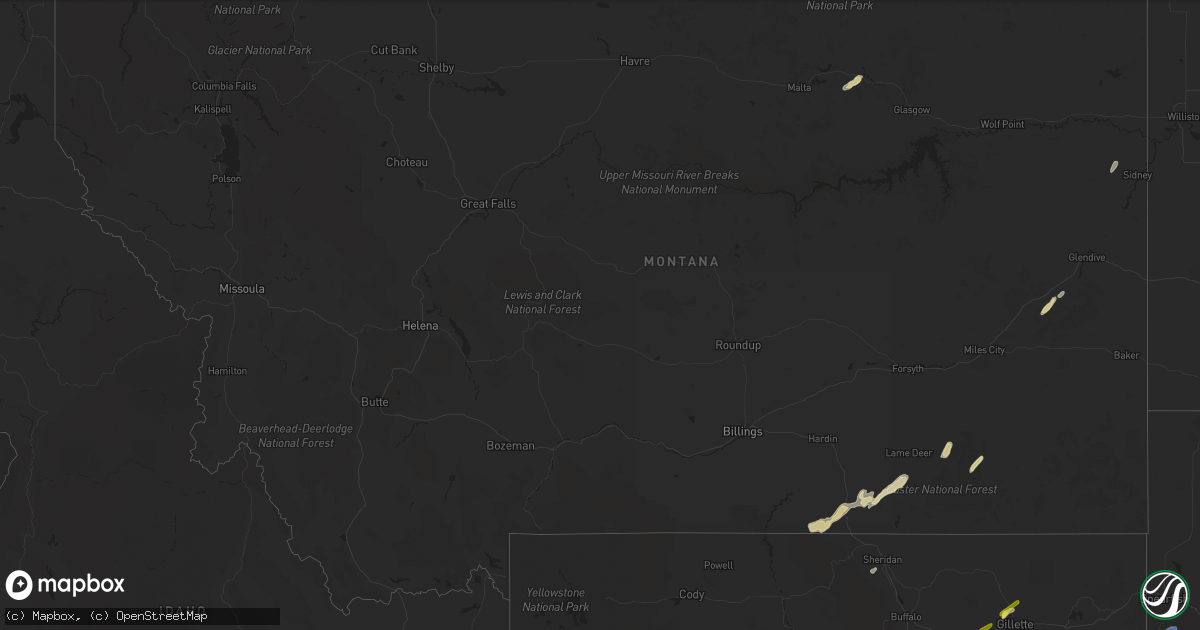
Hail Map in Montana on June 20, 2022
Get this storm
June 20 map
$229
one time, instant access
Download today. No call, no setup
Keep the $229
Bought the map and want the full workflow? Apply the entire $229 to a subscription within 7 days. None of it is wasted.
Every map, not just this one
This buys you this map. Subscription and you get every map we run, in the markets you choose from a few cities to whole states to nationwide. Plus real-time alerts the moment a storm fires.
Contact data
Name, contact info, occupancy, even credit band for addresses in the footprint. You go from where it hit to who to call.
Become the source they trust
Unlimited branding weather history reports on demand. You already have the documented answer ready for the property owner, and you are the one who showed up with it.
Property data and RoofTrace estimates
Pull up any address you have got, its value and the exact code rules for that jurisdiction, straight from One Click Code. Then RoofTrace estimates the squares, pitch, and roof value, priced the way you price.
Storm reports in Montana
Montana
| Date | Description |
|---|---|
| 06/20/20223:25 PM CDT | Several large trees downed and half a roof taken off of a house trailer; lots of small hail. |
| 06/19/20229:27 PM CDT | At 227 PM MDT, severe thunderstorms were located along a line extending from 6 miles northwest of Dayton to 12 miles northwest of Fort Phil Kearny Historical Site, moving east at 10 mph. HAZARD...60 mph wind gusts and quarter size hail. SOURCE...Trained weather spotters report quarter size hail in Dayton with these storms. IMPACT...Hail damage to vehicles is expected. Expect wind damage to roofs, siding, and trees. Locations impacted include... Sheridan, Ranchester, Dayton, Big Horn, Parkman, Banner and Story. |
| 06/19/20228:53 PM CDT | At 152 PM MDT, a severe thunderstorm was located 8 miles south of Lodge Grass, or 33 miles northwest of Sheridan, moving northeast at 35 mph. HAZARD...60 mph wind gusts and half dollar size hail. SOURCE...Radar indicated. IMPACT...Hail damage to vehicles is expected. Expect wind damage to roofs, siding, and trees. Locations impacted include... Busby, Wyola, Kirby and Rosebud Battlefield Park. |
| 06/19/20228:34 PM CDT | At 134 PM MDT, a severe thunderstorm was located 15 miles southeast of Busby, or 35 miles south of Colstrip, moving northeast at 30 mph. HAZARD...60 mph wind gusts and quarter size hail. SOURCE...Radar indicated. IMPACT...Hail damage to vehicles is expected. Expect wind damage to roofs, siding, and trees. Locations impacted include... Ashland, Birney, Birney Village and Northern Cheyenne Indian Reservation. |
| 06/19/20227:24 PM CDT | Mesonet station pnhm8 hoyt 16ese/pine hill. |
All States Impacted by Hail Map on June 20, 2022
Cities Impacted by Hail Map on June 20, 2022
- Fosston, MN
- Lengby, MN
- Crookston, MN
- Euclid, MN
- Red Lake Falls, MN
- Orr, MN
- Lambert, MT
- East Grand Forks, MN
- Thompson, ND
- Grand Forks, ND
- Fisher, MN
- Beltrami, MN
- Fertile, MN
- Wheatland, ND
- Mapleton, ND
- Casselton, ND
- Pillager, MN
- Brainerd, MN
- Fallon, MT
- Gonvick, MN
- Oklee, MN
- Gully, MN
- Goodridge, MN
- Trail, MN
- Plummer, MN
- Naytahwaush, MN
- Ogema, MN
- Callaway, MN
- Bagley, MN
- White Earth, MN
- Waubun, MN
- Detroit Lakes, MN
- Audubon, MN
- Mahnomen, MN
- Erskine, MN
- Canyon, MN
- Cotton, MN
- Cook, MN
- Lame Deer, MT
- Ashland, MT
- Forsyth, MT
- Freeport, MN
- Albany, MN
- Kelliher, MN
- Merrifield, MN
- Ironton, MN
- Crosby, MN
- Grenville, SD
- Sisseton, SD
- Peever, SD
- Eden, SD
- Roslyn, SD
- Littlefork, MN
- Big Falls, MN
- Marcell, MN
- Bovey, MN
- Reynolds, ND
- Hibbing, MN
- Chisholm, MN
- Isabel, SD
- Midland, SD
- Tampa, FL
- Nielsville, MN
- Ada, MN
- Thief River Falls, MN
- Shelly, MN
- Halstad, MN
- Brooks, MN
- Mentor, MN
- Mcintosh, MN
- Caledonia, ND
- Hillsboro, ND
- Pelican Rapids, MN
- Halliday, ND
- Richardton, ND
- Beulah, ND
- Gladstone, ND
- Dodge, ND
- Taylor, ND
- Felton, MN
- Fort Ripley, MN
- Forbes, MN
- Fredonia, ND
- Wishek, ND
- Enderlin, ND
- Sheldon, ND
- Kathryn, ND
- Kulm, ND
- Litchville, ND
- Oriska, ND
- Montpelier, ND
- Valley City, ND
- Edgeley, ND
- Lehr, ND
- Ashley, ND
- Nome, ND
- Fort Ransom, ND
- Fingal, ND
- Dickey, ND
- Jud, ND
- Tower City, ND
- Buffalo, ND
- Lisbon, ND
- Gackle, ND
- Marion, ND
- Grygla, MN
- Saint Hilaire, MN
- Bristol, SD
- Waubay, SD
- Webster, SD
- Gary, SD
- Murdock, MN
- Little Falls, MN
- Aitkin, MN
- Malta, MT
- Saco, MT
- Hinsdale, MT
- Miller, SD
- Pine River, MN
- Shevlin, MN
- Redlake, MN
- Clearbrook, MN
- Leonard, MN
- Argusville, ND
- Harwood, ND
- Presho, SD
- Wanblee, SD
- Draper, SD
- Okaton, SD
- Belvidere, SD
- Kadoka, SD
- Murdo, SD
- Long Valley, SD
- Vivian, SD
- White River, SD
- Gatzke, MN
- Pequot Lakes, MN
- Nisswa, MN
- Verona, ND
- Vale, SD
- Garrison, MN
- Ivanhoe, MN
- Minneota, MN
- Lake Benton, MN
- Flandreau, SD
- Aurora, SD
- Brookings, SD
- Colman, SD
- Ruthton, MN
- Elkton, SD
- Arco, MN
- Taunton, MN
- Cass Lake, MN
- Laporte, MN
- Saxon, WI
- Badger, MN
- Roseau, MN
- Underwood, MN
- Dent, MN
- Talmoon, MN
- Ulen, MN
- Georgetown, MN
- Hawley, MN
- Moorhead, MN
- Borup, MN
- Dilworth, MN
- Perley, MN
- Glyndon, MN
- Fargo, ND
- Deerwood, MN
- Faith, SD
- Dupree, SD
- Dumont, MN
- Wheaton, MN
- Browns Valley, MN
- Beardsley, MN
- Yale, SD
- Huron, SD
- Pierz, MN
- Starbuck, MN
- Glenwood, MN
- Brandt, SD
- Spooner, WI
- Battle Lake, MN
- Henning, MN
- Naubinway, MI
- Newberry, MI
- Frederic, WI
- Shell Lake, WI
- Wolsey, SD
- Virgil, SD
- Alpena, SD
- Volga, SD
- Bruce, SD
- Princeton, MN
- Howard, SD
- Cokato, MN
- Backus, MN
- Atkinson, NE
- Kaycee, WY
- Buffalo, WY
- Chancellor, SD
- Parker, SD
- Amelia, NE
- Stuart, NE
- Burwell, NE
- Humboldt, SD
- Hartford, SD
- Pipestone, MN
- Montrose, SD
- Madison, SD
- Salem, SD
- Winfred, SD
- Scenic, SD
- Wentworth, SD
- Sarasota, FL
- Newcastle, WY
- Trent, SD
- Whitman, NE
- Valentine, NE
- Forbes, ND
- Ellendale, ND
- Decker, MT
- Lodge Grass, MT
- Interior, SD
- Eagle Butte, SD
- Lantry, SD
- Yoder, WY
- Wessington, SD
- Holabird, SD
- Pierre, SD
- Blunt, SD
- Fort Pierre, SD
- Onida, SD
- Harrold, SD
- Saint Lawrence, SD
- Gwinner, ND
- Oakes, ND
- Mitchell, NE
- Hemingford, NE
- Lakeside, NE
- Ellsworth, NE
- Bridgeport, NE
- Angora, NE
- Merriman, NE
- Fifty Lakes, MN
- Claire City, SD
- Newell, SD
- Hendricks, MN
- White, SD
- Seneca, SD
- Highmore, SD
- Faulkton, SD
- Orient, SD
- Marsland, NE
- Fullerton, ND
- Iroquois, SD
- Cavour, SD
- Ironwood, MI
- Hurley, WI
- Newport, NE
- Bassett, NE
- Golden Valley, ND
- Long Prairie, MN
- Swanville, MN
- Randall, MN
- Danube, MN
- Olivia, MN
- Annandale, MN
- Colton, SD
- Wagner, SD
- Dante, SD
- Lynch, NE
- Delmont, SD
- Sargent, NE
- Taylor, NE
- Dalton, MN
- Fergus Falls, MN
- Hyannis, NE
- Union Center, SD
- Johnstown, NE
- Nunda, SD
- Ramona, SD
- Conde, SD
- Doland, SD
- Turton, SD
- Morrill, NE
- Spencer, SD
- Oneill, NE
- Wadena, MN
- Hewitt, MN
- Upson, WI
- Bessemer, MI
- Ramsay, MI
- Wakefield, MI
- Montreal, WI
- Gile, WI
- Iron Belt, WI
- Gillette, WY
- Longville, MN
- Federal Dam, MN
- Walker, MN
- Remer, MN
- Couderay, WI
- Chadron, NE
- Marion, SD
- Harrison, NE
- Dickinson, ND
- Timber Lake, SD
- Otter, MT
- Baxter, MN
- Melrose, MN
- Flensburg, MN
- Burtrum, MN
- Sauk Centre, MN
- Browerville, MN
- Grey Eagle, MN
- Cushing, MN
- Berlin, ND
- Thedford, NE
- Wood Lake, NE
- Bayard, NE
- Mcgrew, NE
- Bingham, NE
- Gering, NE
- Oshkosh, NE
- Torrington, WY
- Wilmot, SD
- Wall, SD
- Wasta, SD
- Luverne, ND
- Gary, MN
- Madison, MN
- Lamoure, ND
- Miltona, MN
- Parkers Prairie, MN
- Alliance, NE
- Stirum, ND
- Leola, SD
- Marietta, MN
- Vergas, MN
- Veteran, WY
- Edgemont, SD
- Cape Coral, FL
- Summit, SD
- Long Pine, NE
- Ainsworth, NE
- Springview, NE
- Hay Springs, NE
- Porter, MN
- Okeechobee, FL
- Fort Lauderdale, FL
- Twin Valley, MN
- Marshall, MN
- Bird Island, MN
- Hector, MN
- Royalton, MN
- Cottonwood, MN
- Hill City, SD
- Winger, MN
- Howard Lake, MN
- Waverly, MN
- Buffalo, MN
- Maple Lake, MN
- Arlington, SD
- Hawk Springs, WY
- Cheyenne, WY
- South Heart, ND
- Clarkfield, MN
- Sunburg, MN
- Tyler, MN
- Jasper, MN
- Woodstock, MN
- Holland, MN
- Hardwick, MN
- Lake Wilson, MN
- Chandler, MN
- Edgerton, MN
- Canova, SD
- Loxahatchee, FL
- Tintah, MN
- Mountain Iron, MN
- Estelline, SD
- Clear Lake, SD
- Evansville, MN
- Clitherall, MN
- Vining, MN
- Glencross, SD
- Holdingford, MN
- Saucier, MS
- Hackensack, MN
- Hertel, WI
- Sheridan, WY
- Wyola, MT
- Birney, MT
- Deer Creek, MN
- Rosholt, SD
- Nashua, MN
- Norcross, MN
- Campbell, MN
- Wendell, MN
- Elbow Lake, MN
- Mills, NE
- Minatare, NE
- Harrisburg, NE
- Ashby, NE
- Trail City, SD
- Osage, WY
- Lefor, ND
- Wolf Point, MT
- Cherry Creek, SD
- Sidney, MT
- Milesville, SD
- New England, ND
- Philip, SD
- Deadwood, SD
- Lead, SD
- Rapid City, SD
- Custer, SD
- Rockham, SD
- Bath, SD
- Aberdeen, SD
- Lower Brule, SD
- Houghton, SD
- Warner, SD
- Hayes, SD
- Roscoe, SD
- Kyle, SD
- Cresbard, SD
- Onaka, SD
- Mellette, SD
- Lebanon, SD
- Westport, SD
- Tolstoy, SD
- Northville, SD
- Ipswich, SD
- Columbia, SD
- Mansfield, SD
- Tripp, SD
- Avon, SD
- Dimock, SD
- Ethan, SD
- Parkston, SD
- Alexandria, SD
- Luverne, MN
- Baltic, SD
- Sioux Falls, SD
- Brandon, SD
- Tea, SD
- Renner, SD
- Crooks, SD
- Dell Rapids, SD
- Garretson, SD
- Valley Springs, SD
- Beaver Creek, MN
- Balaton, MN
- Lennox, SD
- Willow Lake, SD
- De Smet, SD
- Bryant, SD
- Lake Norden, SD
- Carpenter, SD
- Wood Lake, MN
- Sacred Heart, MN
- Granite Falls, MN
- Echo, MN
- Hanley Falls, MN
- Strandburg, SD
- Dawson, MN
- Milan, MN
- Benson, MN
- Henry, SD
- Labolt, SD
- Nevis, MN
- Clinton, MN
- Clark, SD
- Canby, MN
- Bradley, SD
- Akeley, MN
- Twin Brooks, SD
- Staples, MN
- Herman, MN
- Garden City, SD
- Appleton, MN
- Bellingham, MN
- Danvers, MN
- Bertha, MN
- Sebeka, MN
- Brandon, MN
- Villard, MN
- Barrett, MN
- Barry, MN
- New York Mills, MN
- Watson, MN
- Clara City, MN
- Maynard, MN
- Revillo, SD
- Chokio, MN
- New London, MN
- South Shore, SD
- Menahga, MN
- Ortonville, MN
- Florence, SD
- Castlewood, SD
- Garfield, MN
- Vienna, SD
- Kranzburg, SD
- Graceville, MN
- Holloway, MN
- Verndale, MN
- Clontarf, MN
- Osakis, MN
- Hancock, MN
- New Effington, SD
- Correll, MN
- Morris, MN
- Bluffton, MN
- Ortley, SD
- Donnelly, MN
- Kerkhoven, MN
- Milbank, SD
- Stockholm, SD
- Pennock, MN
- Raymond, MN
- Marvin, SD
- Boyd, MN
- Hazel, SD
- Ottertail, MN
- Perham, MN
- Montevideo, MN
- Richville, MN
- Goodwin, SD
- Aldrich, MN
- Hayti, SD
- Brooten, MN
- Watertown, SD
- Wallace, SD
- Corona, SD
- Ashby, MN
- Park Rapids, MN
- Belgrade, MN
- West Fargo, ND
- Hitterdal, MN
- Bemidji, MN
- Lake Park, MN
- Davenport, ND
- Leonard, ND
- Solway, MN
- Hitchcock, SD
- Emmet, NE
- Zap, ND


