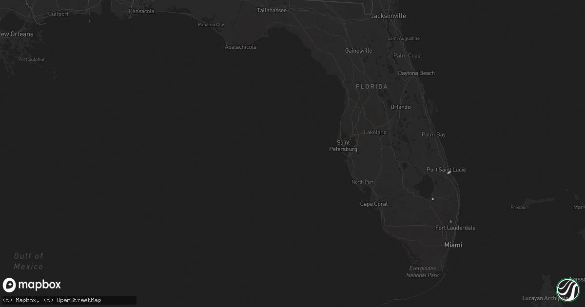
Hail Map in Florida on June 20, 2021
Get this storm
June 20 map
$229
one time, instant access
Download today. No call, no setup
Keep the $229
Bought the map and want the full workflow? Apply the entire $229 to a subscription within 7 days. None of it is wasted.
Every map, not just this one
This buys you this map. Subscription and you get every map we run, in the markets you choose from a few cities to whole states to nationwide. Plus real-time alerts the moment a storm fires.
Contact data
Name, contact info, occupancy, even credit band for addresses in the footprint. You go from where it hit to who to call.
Become the source they trust
Unlimited branding weather history reports on demand. You already have the documented answer ready for the property owner, and you are the one who showed up with it.
Property data and RoofTrace estimates
Pull up any address you have got, its value and the exact code rules for that jurisdiction, straight from One Click Code. Then RoofTrace estimates the squares, pitch, and roof value, priced the way you price.
Storm reports in Florida
Florida
| Date | Description |
|---|---|
| 06/20/20213:58 PM CDT | Very large hardwood tree branches downed within the city of coral springs. Video shared via social media by the city. Radar estimated winds were around 50 kt / 58 mph d |
| 06/20/20213:57 PM CDT | Photo via social media of large downed tree on the southern side of the intersection of banks road and west copans road. Time estimated from radar. |
| 06/20/20213:41 PM CDT | Small branches and palm fronds down. Time estimated. Radar suggests winds of 50 to 60 mph in the area around the time of this report. |
| 06/20/202112:57 PM CDT | 911 call center reports downed power lines... Transformers... And trees along martin luther king jr ave. Call came in at 1:17pm. Time estimated using radar. |
| 06/20/20215:36 AM CDT | At 1036 AM EDT, a severe thunderstorm was located over Archer, or 12 miles northeast of Bronson, moving northeast at 20 mph. HAZARD...60 mph wind gusts. SOURCE...Radar indicated. IMPACT...Expect damage to roofs, siding, and trees. Locations impacted include... Gainesville, Alachua, Hawthorne, Archer, University Of Florida, Rochelle, Cross Creek, Orange Heights, Gainesville Airport and Newnans Lake. |
| 06/19/202111:41 PM CDT | At 441 PM EDT, severe thunderstorms were located along a line extending from 6 miles west of Coral Springs to Margate, moving south at 5 mph. HAZARD...60 mph wind gusts and quarter size hail. SOURCE...Radar indicated. IMPACT...Hail damage to vehicles is expected. Expect wind damage to roofs, siding, and trees. Locations impacted include... Fort Lauderdale, Coral Springs, Pompano Beach, Davie and Plantation. |
| 06/19/202111:20 PM CDT | At 420 PM EDT, a severe thunderstorm was located 7 miles northwest of Coral Springs, moving east at 15 mph. HAZARD...60 mph wind gusts and quarter size hail. SOURCE...Radar indicated. IMPACT...Hail damage to vehicles is expected. Expect wind damage to roofs, siding, and trees. Locations impacted include... Fort Lauderdale, Coral Springs, Pompano Beach, Sunrise and Boca Raton. |
| 06/19/202111:11 PM CDT | At 410 PM EDT, severe thunderstorms were located along a line extending from near East Toll Gate On Alligator Alley to near Intersection Krome And U.S. 27, moving northeast at 5 mph. HAZARD...60 mph wind gusts and quarter size hail. SOURCE...Radar indicated. IMPACT...Hail damage to vehicles is expected. Expect wind damage to roofs, siding, and trees. Locations impacted include... Pembroke Pines, Miramar, Davie, Plantation and Sunrise. |
All States Impacted by Hail Map on June 20, 2021
Cities Impacted by Hail Map on June 20, 2021
- Sycamore, IL
- Dekalb, IL
- Clare, IL
- Murray, IA
- Mercer, MO
- Princeton, MO
- Cainsville, MO
- Van Wert, IA
- Walnut, IL
- Chillicothe, MO
- Callao, MO
- Carmel, IN
- Indianapolis, IN
- Pioneer, OH
- Kingdom City, MO
- Fulton, MO
- Long Grove, IA
- Lees Summit, MO
- Grain Valley, MO
- Hillsboro, IA
- Donnellson, IA
- Farmington, IA
- Higbee, MO
- Dundee, MI
- Ida, MI
- Monroe, MI
- Petersburg, MI
- Faucett, MO
- Higginsville, MO
- Wakarusa, IN
- Goshen, IN
- West Point, IA
- Fort Madison, IA
- Berrien Springs, MI
- Browning, MO
- Trenton, MO
- Humphreys, MO
- Spickard, MO
- Jamesport, MO
- Galt, MO
- Laredo, MO
- Chula, MO
- Ridott, IL
- Davis, IL
- Durand, IL
- Pecatonica, IL
- Rock City, IL
- Huntsville, MO
- Bevier, MO
- Excello, MO
- New Cambria, MO
- Clifton Hill, MO
- Salisbury, MO
- Macon, MO
- El Dorado Springs, MO
- Schell City, MO
- Harwood, MO
- Lyndon, KS
- Richmond, KS
- Quenemo, KS
- Williamsburg, KS
- Princeton, KS
- Ottawa, KS
- Osage City, KS
- Melvern, KS
- Pomona, KS
- Paola, KS
- Roanoke, IN
- Cunningham, KS
- La Crosse, IN
- North Judson, IN
- San Pierre, IN
- Brownsburg, IN
- Grenville, NM
- Clayton, NM
- Green City, MO
- Green Castle, MO
- Lambertville, MI
- Temperance, MI
- Shelbina, MO
- Colorado Springs, CO
- Cassopolis, MI
- Niles, MI
- Dowagiac, MI
- Harris, MO
- Buffalo, OK
- Mooreland, OK
- Jacksonville, MO
- Cairo, MO
- Victor, CO
- Clark, MO
- Eau Claire, MI
- Sodus, MI
- Knox, IN
- Hamlet, IN
- Linneus, MO
- Purdin, MO
- Armstrong, MO
- Fayette, MO
- Glasgow, MO
- Lorimor, IA
- Creston, IA
- Afton, IA
- Thayer, IA
- Mendon, MO
- Burlington, KS
- Amazonia, MO
- Clarksdale, MO
- Helena, MO
- Cosby, MO
- Saint Joseph, MO
- Savannah, MO
- Covert, MI
- Coloma, MI
- El Dorado, KS
- Leon, KS
- Augusta, KS
- Ridgeway, MO
- Berryton, KS
- Wakarusa, KS
- Benton Harbor, MI
- Hartford, MI
- Shannon, IL
- Preston, IA
- Laclede, MO
- Allison, IA
- Lagrange, IN
- Lebo, KS
- Neosho Rapids, KS
- Freeport, IL
- Monroe, IA
- Prairie City, IA
- Amity, MO
- Stevensville, MI
- Decatur, MI
- Saint Joseph, MI
- Watervliet, MI
- Buchanan, MI
- Lawrence, MI
- Bangor, MI
- Berrien Center, MI
- Odessa, MO
- Bates City, MO
- Fort Supply, OK
- Bremen, IN
- Ripley, NY
- North East, PA
- Grinnell, IA
- Kellogg, IA
- Eagleville, MO
- Leon, IA
- Lineville, IA
- Kellerton, IA
- Lamoni, IA
- Grand River, IA
- Davis City, IA
- Garden Grove, IA
- Decatur, IA
- Blythedale, MO
- Ellston, IA
- Boonville, MO
- Wellington, MO
- Mayview, MO
- Udall, KS
- Payne, OH
- Wauseon, OH
- Ridgeville Corners, OH
- Stryker, OH
- Paulding, OH
- Liberty Center, OH
- Woodburn, IN
- Antwerp, OH
- Napoleon, OH
- Monroeville, IN
- Defiance, OH
- Archbold, OH
- Ney, OH
- Sherwood, OH
- Cecil, OH
- Rothville, MO
- Sumner, MO
- Brookfield, MO
- Meadville, MO
- Marceline, MO
- Milan, MO
- Novinger, MO
- Osseo, MI
- Camden, MI
- Montpelier, OH
- Tippecanoe, IN
- Argos, IN
- Rochester, IN
- Bourbon, IN
- Valley Center, KS
- Sedgwick, KS
- Florissant, CO
- Richards, MO
- Nevada, MO
- Walker, MO
- Rich Hill, MO
- Rockville, MO
- Nappanee, IN
- Plymouth, IN
- Aurora, IL
- Humeston, IA
- Allerton, IA
- Breckenridge, MO
- Mount Carmel, PA
- Leck Kill, PA
- Pitman, PA
- Klingerstown, PA
- Coal Township, PA
- Shamokin, PA
- Elysburg, PA
- Harrisonville, MO
- Leonard, MO
- Atlanta, MO
- Wooldridge, MO
- Jamestown, MO
- Peru, IA
- Mount Carroll, IL
- Lanark, IL
- Forreston, IL
- Chadwick, IL
- Lentner, MO
- Clarence, MO
- Madison, MO
- Keytesville, MO
- Harmon, IL
- Rock Falls, IL
- Wichita, KS
- Keyes, OK
- Goodwell, OK
- Moberly, MO
- Knob Noster, MO
- Hartford, KS
- Coggon, IA
- Walker, IA
- Rocky Ford, CO
- La Junta, CO
- Pascagoula, MS
- Tampico, IL
- New Bedford, IL
- Holden, MO
- Newton, IA
- Wever, IA
- Keosauqua, IA
- Lomax, IL
- Dallas City, IL
- Mount Sterling, IA
- Niota, IL
- Bonaparte, IA
- Baroda, MI
- Galien, MI
- New Carlisle, IN
- Cortland, OH
- Kirksville, MO
- Lucerne, MO
- Powersville, MO
- Newtown, MO
- Sigourney, IA
- Washington, IA
- Harper, IA
- Keota, IA
- Anabel, MO
- Brunswick, MO
- Oregon, MO
- Slater, MO
- La Salle, MI
- Pilot Grove, MO
- Louisburg, KS
- Topeka, KS
- Etna Green, IN
- Naperville, IL
- Warrenville, IL
- Nelson, MO
- Marshall, MO
- Blackwater, MO
- Wheeling, MO
- Lecompton, KS
- Rolling Prairie, IN
- Mill Creek, IN
- Corder, MO
- Andrews, IN
- Huntington, IN
- Liberal, KS
- Colfax, IA
- Three Oaks, MI
- Sawyer, MI
- South Bend, IN
- Manzanola, CO
- Ordway, CO
- Coden, AL
- Danville, IA
- New London, IA
- Barnard, MO
- Conception Junction, MO
- Edwardsburg, MI
- La Porte, IN
- Maple Park, IL
- Waldron, MI
- Edon, OH
- Pittsford, MI
- Turpin, OK
- Bethany, MO
- Gilman City, MO
- Miles, IA
- Sabula, IA
- Aredale, IA
- Rea, MO
- Rosendale, MO
- La Harpe, KS
- Novelty, MO
- Walkerton, IN
- Hanna, IN
- Fort Wayne, IN
- Vassar, KS
- Redfield, KS
- Uniontown, KS
- Oak Grove, MO
- Lakeville, IN
- Pella, IA
- Sully, IA
- Lynnville, IA
- Reasnor, IA
- Runnells, IA
- Otley, IA
- Swan, IA
- Dalton, MO
- Houstonia, MO
- Hughesville, MO
- Le Roy, KS
- Lone Jack, MO
- Alma, MO
- Weldon, IA
- Shannon City, IA
- Osceola, IA
- Diagonal, IA
- Mount Ayr, IA
- Tingley, IA
- Malta Bend, MO
- Gilliam, MO
- Eureka, KS
- Rose Hill, KS
- Douglass, KS
- Gilman, IA
- Chagrin Falls, OH
- Prophetstown, IL
- Sheffield, IL
- Greenwood, MO
- North Liberty, IN
- Cripple Creek, CO
- Centerview, MO
- Warrensburg, MO
- Kingsville, MO
- Greene, IA
- Hampton, IA
- Sheffield, IA
- Topeka, IN
- Sturgis, MI
- Manchester, IA
- Franklin, PA
- Mingo, IA
- Belle Glade, FL
- Kincaid, KS
- Welda, KS
- Colony, KS
- Coats, KS
- Pratt, KS
- Winamac, IN
- Francesville, IN
- Medaryville, IN
- Bunceton, MO
- Milledgeville, IL
- Savanna, IL
- Jensen Beach, FL
- Palm City, FL
- Stuart, FL
- Port Saint Lucie, FL
- Elkhart, IN
- Arlington, KS
- Andover, KS
- Zionsville, IN
- Towanda, KS
- La Plata, MO
- Dougherty, IA
- Dumont, IA
- Bristow, IA
- Greeley, KS
- Garnett, KS
- Waverly, KS
- Peculiar, MO
- Kouts, IN
- Wheatfield, IN
- De Witt, MO
- Carrollton, MO
- Coral Springs, FL
- Osceola, IN
- Mishawaka, IN
- Gibbs, MO
- Hurdland, MO
- Westphalia, KS
- Miami, MO
- Adrian, MO
- Drexel, MO
- Delmar, IA
- Lost Nation, IA
- South Haven, MI
- Pueblo, CO
- Trimble, MO
- Edgerton, MO
- Plattsburg, MO
- Hugoton, KS
- Montezuma, IA
- Malcom, IA
- Stockton, IL
- Sweet Springs, MO
- Blackburn, MO
- Lexington, MO
- Waverly, MO
- Eldridge, IA
- Walcott, IA
- Davenport, IA
- Donahue, IA
- Goodhue, MN
- Mazeppa, MN
- Martinsville, MO
- New Hampton, MO
- Pollock, MO
- Gulf Shores, AL
- Mount Morris, IL
- Oregon, IL
- Polo, IL
- Rockton, IL
- Dakota, IL
- Shirland, IL
- Waterman, IL
- Hinckley, IL
- Benton, KS
- Greenwich, KS
- Kechi, KS
- Columbia City, IN
- Osceola, MO
- Grand Mound, IA
- De Witt, IA
- Lenox, IA
- Gallatin, MO
- Rockwell, IA
- Belton, MO
- Stilwell, KS
- Cleveland, MO
- Bucyrus, KS
- Raymore, MO
- Worthington, IA
- Hopkinton, IA
- Mulvane, KS
- Alva, OK
- Derby, KS
- Winthrop, IA
- Masonville, IA
- Byron, IL
- Stillman Valley, IL
- Camden Point, MO
- Dearborn, MO
- Sawyer, KS
- Medicine Lodge, KS
- Leawood, KS
- Blue Springs, MO
- Independence, MO
- Pleasant Hill, MO
- Buckner, MO
- Overland Park, KS
- Kansas City, MO
- Grandview, MO
- Napoleon, MO
- Spragueville, IA
- Hanover, IL
- Elizabeth, IL
- Bernard, IA
- Bryant, IA
- Bellevue, IA
- La Motte, IA
- Maquoketa, IA
- Zwingle, IA
- Shelbyville, MO
- Centralia, MO
- Hannibal, MO
- Louisiana, MO
- Monroe City, MO
- Farber, MO
- Bowling Green, MO
- Frankford, MO
- Benton City, MO
- Thompson, MO
- Vandalia, MO
- Rush Hill, MO
- Hunnewell, MO
- Stoutsville, MO
- Paris, MO
- Middletown, MO
- Wellsville, MO
- Santa Fe, MO
- Perry, MO
- New London, MO
- Curryville, MO
- Holliday, MO
- Emden, MO
- Bethel, MO
- Mexico, MO
- Martinsburg, MO
- Laddonia, MO
- Montgomery City, MO
- Center, MO
- Truxton, MO
- Williamsburg, MO
- O'Fallon, MO
- Lake Saint Louis, MO
- Auxvasse, MO
- Troy, MO
- Sturgeon, MO
- Truesdale, MO
- High Hill, MO
- Moscow Mills, MO
- Bellflower, MO
- Jonesburg, MO
- Hallsville, MO
- Foristell, MO
- New Florence, MO
- Harrisburg, MO
- Rocheport, MO
- Wentzville, MO
- Columbia, MO
- Hawk Point, MO
- Wright City, MO
- Warrenton, MO
- Hartsburg, MO
- Tebbetts, MO
- Rhineland, MO
- Steedman, MO
- New Bloomfield, MO
- Portland, MO
- Morrison, MO
- Berger, MO
- New Franklin, MO
- Centertown, MO
- Mokane, MO
- Marthasville, MO
- California, MO
- Ashland, MO
- Chamois, MO
- Franklin, MO
- Prairie Home, MO
- Hermann, MO
- Gobles, MI
- Paw Paw, MI
- Lawton, MI
- Mattawan, MI
- Kalamazoo, MI
- Centreville, MI
- Marshall, MI
- Webberville, MI
- Olivet, MI
- Sherwood, MI
- Onondaga, MI
- Burr Oak, MI
- Union City, MI
- Albion, MI
- Bronson, MI
- Rives Junction, MI
- Athens, MI
- Tekonsha, MI
- Dansville, MI
- Homer, MI
- Eaton Rapids, MI
- Mason, MI
- Burlington, MI
- Colon, MI
- Leslie, MI
- Williamston, MI
- Springport, MI
- Adrian, MI
- Fayette, OH
- Morenci, MI
- Onsted, MI
- Sand Creek, MI
- Hudson, MI
- Manitou Beach, MI
- Clayton, MI
- Deerfield, MI
- Blissfield, MI
- Whitehouse, OH
- Swanton, OH
- Grand Rapids, OH
- Waterville, OH
- Delta, OH
- Neapolis, OH
- Monclova, OH
- Granger, IN
- Notre Dame, IN
- Addison, MI
- North Adams, MI
- Hillsdale, MI
- Jonesville, MI
- Palmyra, MI
- Portage, MI
- Schoolcraft, MI
- Scotts, MI
- Marcellus, MI
- Gary, IN
- Westmont, IL
- Hickory Hills, IL
- Justice, IL
- Whiting, IN
- Downers Grove, IL
- Crestwood, IL
- Oswego, IL
- Woodridge, IL
- Lisle, IL
- Summit Argo, IL
- Oak Lawn, IL
- Plainfield, IL
- Burbank, IL
- Lemont, IL
- Palos Hills, IL
- East Chicago, IN
- Hometown, IL
- Willow Springs, IL
- Bridgeview, IL
- Blue Island, IL
- Palos Park, IL
- Chicago, IL
- Alsip, IL
- Bristol, IL
- Bolingbrook, IL
- La Grange, IL
- Evergreen Park, IL
- Montgomery, IL
- Sugar Grove, IL
- Hammond, IN
- Elburn, IL
- Willowbrook, IL
- Riverdale, IL
- Darien, IL
- Worth, IL
- Palos Heights, IL
- Big Rock, IL
- Chicago Ridge, IL
- Flossmoor, IL
- Newark, IL
- Chicago Heights, IL
- Matteson, IL
- Highland, IN
- Schererville, IN
- Romeoville, IL
- Orland Park, IL
- Homer Glen, IL
- Glenwood, IL
- Homewood, IL
- Munster, IN
- Chesterton, IN
- Oak Forest, IL
- Griffith, IN
- Merrillville, IN
- Sheridan, IL
- Park Forest, IL
- Posen, IL
- Olympia Fields, IL
- Dyer, IN
- Frankfort, IL
- Earlville, IL
- Calumet City, IL
- Hobart, IN
- Leland, IL
- Portage, IN
- New Lenox, IL
- Harvey, IL
- Saint John, IN
- Millington, IL
- Lake Station, IN
- Union Mills, IN
- Tinley Park, IL
- Minooka, IL
- Crest Hill, IL
- Steger, IL
- Joliet, IL
- Dolton, IL
- Millbrook, IL
- Markham, IL
- Lockport, IL
- Mendota, IL
- Thornton, IL
- Midlothian, IL
- Country Club Hills, IL
- Michigan City, IN
- Crete, IL
- Sandwich, IL
- Wanatah, IN
- Crown Point, IN
- South Holland, IL
- Valparaiso, IN
- Westville, IN
- Mokena, IL
- Lansing, IL
- Hazel Crest, IL
- Yorkville, IL
- Lowell, IN
- Cedar Lake, IN
- Hebron, IN
- Boone Grove, IN
- River Forest, IL
- Stone Park, IL
- Elmwood Park, IL
- Franklin Park, IL
- Roselle, IL
- Bensenville, IL
- Lincolnwood, IL
- Arlington Heights, IL
- Harwood Heights, IL
- Medinah, IL
- Oak Park, IL
- Bloomingdale, IL
- Mount Prospect, IL
- Addison, IL
- River Grove, IL
- Elmhurst, IL
- Park Ridge, IL
- Itasca, IL
- Elk Grove Village, IL
- Wood Dale, IL
- Schaumburg, IL
- Melrose Park, IL
- Berkeley, IL
- Maywood, IL
- Niles, IL
- Schiller Park, IL
- Des Plaines, IL
- Westfield, IN
- Fountain, CO


