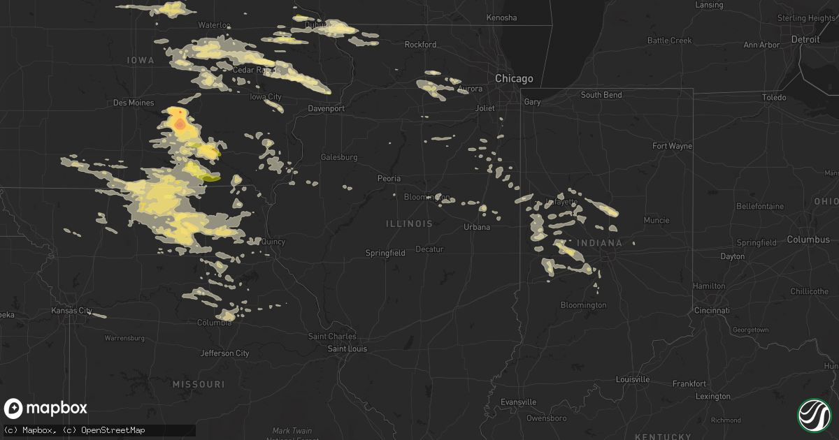
Hail Map in Illinois on June 20, 2015
Get this storm
June 20 map
$229
one time, instant access
Download today. No call, no setup
Keep the $229
Bought the map and want the full workflow? Apply the entire $229 to a subscription within 7 days. None of it is wasted.
Every map, not just this one
This buys you this map. Subscription and you get every map we run, in the markets you choose from a few cities to whole states to nationwide. Plus real-time alerts the moment a storm fires.
Contact data
Name, contact info, occupancy, even credit band for addresses in the footprint. You go from where it hit to who to call.
Become the source they trust
Unlimited branding weather history reports on demand. You already have the documented answer ready for the property owner, and you are the one who showed up with it.
Property data and RoofTrace estimates
Pull up any address you have got, its value and the exact code rules for that jurisdiction, straight from One Click Code. Then RoofTrace estimates the squares, pitch, and roof value, priced the way you price.
Storm reports in Illinois
Illinois
| Date | Description |
|---|---|
| 06/20/20154:35 PM CDT | A tree blown down in the city of freeport. |
| 06/20/20153:22 PM CDT | Tree down on a house and several small branches down in town. Diameter unknown. Delayed report. |
| 06/20/201512:15 AM CDT | A local report indicates 63 MPH wind near XENIA |
| 06/19/201511:47 PM CDT | 4 to 8 inch diameter tree limbs down |
| 06/19/201511:47 PM CDT | A local report indicates 67 MPH wind near 1 N HOOPESTON |
| 06/19/201511:35 PM CDT | Roof and structural damage...12x12 shed destroyed. Numerous trees and large branches down. Other minor damage...roof shingles and fences. |
| 06/19/201511:30 PM CDT | A local report indicates 62 MPH wind near HOOPESTON |
| 06/19/201511:30 PM CDT | Trees down |
| 06/19/201511:03 PM CDT | Tree limbs down northwest of buckley near i-57. Facebook report. Time estimated. |
| 06/19/201510:45 PM CDT | Tree down on grand ave. From wand-tv. |
| 06/19/201510:35 PM CDT | Small tree limbs down |
| 06/19/201510:14 PM CDT | Tree down on mobile home |
| 06/19/201510:09 PM CDT | Tree down blocking rt. 54. From logan co. Em. |
| 06/19/201510:05 PM CDT | Tree limb down on old 36 |
| 06/19/201510:05 PM CDT | At fourth street and pond. One tree snapped onto power lines. Via social media. |
| 06/19/20159:58 PM CDT | Near route 18. One tree and power lines down. |
| 06/19/20159:55 PM CDT | Trees down at hearts prairie rd and rt. 104 |
| 06/19/20159:50 PM CDT | Trees down |
| 06/19/20159:49 PM CDT | Tree down on rt. 89 |
| 06/19/20159:39 PM CDT | One foot diameter tree down on rt. 26. Also power lines down. |
| 06/19/20159:25 PM CDT | 3 to 4 inch diameter tree limbs down |
| 06/19/20159:15 PM CDT | Tree down |
| 06/19/20159:05 PM CDT | Power line down |
| 06/19/20159:00 PM CDT | 11 inch diameter tree snapped off at 8th and jefferson street . |
| 06/19/20158:50 PM CDT | Tree and power pole down |
| 06/19/20158:50 PM CDT | Tree down |
| 06/19/20158:45 PM CDT | Trees down |
| 06/19/20158:45 PM CDT | Trees down in town |
| 06/19/20158:36 PM CDT | Trees down |
| 06/19/20158:36 PM CDT | Several trees and power lines down in town |
| 06/19/20158:12 PM CDT | Trees down across northern part of county...including good hope and macomb. Time estimated from radar. |
| 06/19/20158:01 PM CDT | Power lines down...time estimated from radar. |
| 06/19/20157:45 PM CDT | Trees down across roads. Power out. Time estimated. |
All States Impacted by Hail Map on June 20, 2015
Cities Impacted by Hail Map on June 20, 2015
- Mount Union, IA
- Winfield, IA
- Olds, IA
- New London, IA
- Mount Pleasant, IA
- Mount Vernon, IA
- Cedar Rapids, IA
- Willow City, ND
- Charlottesville, VA
- Philip, SD
- Wall, SD
- Quinn, SD
- Wasta, SD
- Kadoka, SD
- Tama, IA
- Garwin, IA
- Marshalltown, IA
- Toledo, IA
- Montour, IA
- Le Grand, IA
- Greencastle, IN
- Clayton, IN
- Fillmore, IN
- Mooresville, IN
- Stilesville, IN
- Monrovia, IN
- Coatesville, IN
- Martinsville, IN
- Ambia, IN
- Aneta, ND
- Saint Cloud, FL
- Auxvasse, MO
- Centralia, MO
- Columbia, MO
- Hallsville, MO
- Thompson, MO
- Mount Dora, FL
- Eustis, FL
- Lucerne, MO
- Princeton, MO
- Powersville, MO
- Mullen, NE
- Fingal, ND
- Rapid City, SD
- Merriman, NE
- Hermosa, SD
- Fairburn, SD
- Pine Ridge, SD
- Cody, NE
- Hot Springs, SD
- Allen, SD
- Porcupine, SD
- Rushville, NE
- Manderson, SD
- Buffalo Gap, SD
- Ashby, NE
- Gordon, NE
- Hay Springs, NE
- Pringle, SD
- Kyle, SD
- Batesland, SD
- Tuthill, SD
- Wounded Knee, SD
- Martin, SD
- Valentine, NE
- Custer, SD
- Whitman, NE
- Lovilia, IA
- Albia, IA
- Chariton, IA
- Towner, ND
- Newcastle, WY
- Upton, WY
- Williamston, NC
- Exline, IA
- Wever, IA
- Humphreys, MO
- Scottsville, VA
- Palmyra, VA
- Troy, VA
- Weldon, IA
- Grand River, IA
- Van Wert, IA
- Woodbridge, VA
- Fairfax Station, VA
- Occoquan, VA
- Springfield, VA
- Fort Belvoir, VA
- Alexandria, VA
- Lorton, VA
- Stockton, IL
- Devils Lake, ND
- Gillette, WY
- Dysart, IA
- Traer, IA
- Garrison, IA
- Gladbrook, IA
- Iowa Falls, IA
- Mexico, MO
- Benton City, MO
- Martinsburg, MO
- Bisbee, ND
- Egeland, ND
- Cando, ND
- Starkweather, ND
- Diagonal, IA
- Marshall, IN
- Bloomingdale, IN
- Montezuma, IN
- Clarence, IA
- Stanwood, IA
- Mechanicsville, IA
- Lowden, IA
- Kellerton, IA
- Vanceboro, NC
- Kirksville, MO
- Novinger, MO
- Sturgis, SD
- Fort Meade, SD
- Osage, WY
- Crawfordsville, IN
- Henderson, NC
- Christmas, FL
- Orlando, FL
- Rugby, ND
- Lead, SD
- Eldora, IA
- New Providence, IA
- Oriska, ND
- Valley City, ND
- Tower City, ND
- Marion, IA
- Robins, IA
- Faith, SD
- Dupree, SD
- Newburg, ND
- Westhope, ND
- Souris, ND
- Martin, ND
- Harvey, ND
- Sandy Hook, VA
- Powhatan, VA
- Gum Spring, VA
- Maidens, VA
- Mineral, VA
- Goochland, VA
- Rozet, WY
- Union Center, SD
- White Owl, SD
- Mud Butte, SD
- Enning, SD
- Oral, SD
- Milan, MO
- Green City, MO
- Ottumwa, IA
- Agency, IA
- Bloomfield, IA
- Arnold, NE
- Carman, IL
- Naples, FL
- Moorcroft, WY
- Hampton, IA
- Dumont, IA
- Parkersburg, IA
- Geneva, IA
- Allison, IA
- Kesley, IA
- Aplington, IA
- Ackley, IA
- Mcville, ND
- Aurora, NC
- Washington, DC
- Arlington, VA
- Fort Myer, VA
- Gladstone, VA
- Appomattox, VA
- Concord, VA
- Timber Lake, SD
- Anamosa, IA
- Forest, IN
- Kempton, IN
- Russiaville, IN
- Atlanta, IN
- Tipton, IN
- Sharpsville, IN
- Tracy, IA
- Leighton, IA
- Harvey, IA
- Pella, IA
- Oskaloosa, IA
- Grace City, ND
- Hayes, SD
- Lithia, FL
- Mulberry, FL
- Crary, ND
- Webster, ND
- West Liberty, IA
- Wahpeton, ND
- Hudson, IA
- Madison, MO
- Cairo, MO
- Beaman, IA
- Conrad, IA
- Hiawatha, IA
- Springville, IA
- Toddville, IA
- Vinton, IA
- Shellsburg, IA
- Center Point, IA
- Alburnett, IA
- Palo, IA
- Martelle, IA
- Centerville, IA
- Udell, IA
- Blakesburg, IA
- Drakesville, IA
- Moulton, IA
- Moravia, IA
- Unionville, IA
- Dazey, ND
- Hannaford, ND
- Roachdale, IN
- Waveland, IN
- New Market, IN
- Danville, IN
- New Ross, IN
- North Salem, IN
- Bainbridge, IN
- Ladoga, IN
- Yorkville, IL
- Oswego, IL
- Sugar Grove, IL
- Big Rock, IL
- Aurora, IL
- Montgomery, IL
- Bristol, IL
- Plano, IL
- Hopkinton, IA
- Woodford, VA
- Port Royal, VA
- Bowling Green, VA
- Veedersburg, IN
- Ransom, IL
- Streator, IL
- Waterford, VA
- Tuscarora, MD
- Lovettsville, VA
- Purcellville, VA
- Leesburg, VA
- Point Of Rocks, MD
- Tremont, IL
- Paris, MO
- Pollocksville, NC
- Elburn, IL
- Maple Park, IL
- Black Hawk, SD
- Corydon, IA
- Promise City, IA
- Esmond, ND
- Maddock, ND
- Fort Pierre, SD
- Midland, SD
- Stapleton, NE
- Lithonia, GA
- Stone Mountain, GA
- Cooperstown, ND
- Winigan, MO
- New Boston, MO
- Ethel, MO
- Green Castle, MO
- Elmer, MO
- Novelty, MO
- Edina, MO
- Glenfield, ND
- Deadwood, SD
- Piedmont, SD
- Bowdon, ND
- Fessenden, ND
- Hill City, SD
- Brady, NE
- Goldsmith, IN
- Bethany, MO
- Cumberland, VA
- Farmville, VA
- Mchenry, ND
- Foosland, IL
- Donahue, IA
- Long Grove, IA
- Ely, IA
- Calamus, IA
- Buckingham, IA
- Wheatland, IA
- Dixon, IA
- Morley, IA
- New Liberty, IA
- La Porte City, IA
- Clutier, IA
- Lisbon, IA
- Newhall, IA
- Grand Mound, IA
- Bennett, IA
- Lost Nation, IA
- Reinbeck, IA
- Eldridge, IA
- Olin, IA
- Saint Michael, ND
- Arthur, NE
- Malta, IL
- Isabel, SD
- Tolna, ND
- Binford, ND
- Warwick, ND
- Wyaconda, MO
- Gorin, MO
- Luray, MO
- Galena, MD
- Salem, IA
- Frostproof, FL
- Unionville, MO
- Pollock, MO
- Galena, IL
- Scales Mound, IL
- McLaughlin, SD
- Oviedo, FL
- Lamoni, IA
- Clearfield, IA
- Lenox, IA
- Sharpsburg, IA
- Gravity, IA
- Corning, IA
- Ruther Glen, VA
- Iowa City, IA
- Romney, IN
- Maysville, NC
- Cainsville, MO
- Gibbs, MO
- Browning, MO
- Davis City, IA
- Hurdland, MO
- Greentop, MO
- Seymour, IA
- Leon, IA
- Glenwood, MO
- Harris, MO
- Coatsville, MO
- Cincinnati, IA
- Bucklin, MO
- Brashear, MO
- Mercer, MO
- Purdin, MO
- Livonia, MO
- La Plata, MO
- Allerton, IA
- Clio, IA
- Knox City, MO
- Newtown, MO
- Newark, MO
- Lineville, IA
- Delphi, IN
- Bringhurst, IN
- Cutler, IN
- Pattonsburg, MO
- New Hampton, MO
- McFall, MO
- Emden, MO
- Hunnewell, MO
- Shelbina, MO
- Mount Auburn, IA
- Mooreton, ND
- Leonard, ND
- Mcleod, ND
- Walcott, ND
- Wyndmere, ND
- Barney, ND
- Bussey, IA
- Sully, IA
- Lynnville, IA
- Reasnor, IA
- Otley, IA
- Beacon, IA
- Monroe, IA
- New Sharon, IA
- Knoxville, IA
- University Park, IA
- Sundance, WY
- Pine Village, IN
- Williamsport, IN
- Attica, IN
- Bates City, MO
- Blue Springs, MO
- Odessa, MO
- Oak Grove, MO
- Grain Valley, MO
- Independence, MO
- Bradenton, FL
- Brazil, IN
- Carbon, IN
- Rockville, IN
- Cascade, IA
- Morgantown, IN
- De Witt, IA
- La Salle, IL
- Kenansville, FL
- Fort Hancock, TX
- Nemo, SD
- Smithwick, SD
- Oelrichs, SD
- Edgemont, SD
- Apple River, IL
- Shullsburg, WI
- Elizabeth, IL
- Dubuque, IA
- La Motte, IA
- Cuba City, WI
- Bellevue, IA
- Peosta, IA
- East Dubuque, IL
- Hazel Green, WI
- Keystone, SD
- Hyannis, NE
- Bingham, NE
- Atlanta, MO
- Boswell, IN
- Fowler, IN
- Castalia, NC
- Indian Lake Estates, FL
- Lake Wales, FL
- Reelsville, IN
- Rantoul, IL
- Jamesport, MO
- Coffey, MO
- Jameson, MO
- Palmyra, MO
- Washington, VA
- Sperryville, VA
- Woodville, VA
- Bumpass, VA
- Cartersville, VA
- Waynetown, IN
- Wingate, IN
- Colfax, IN
- Thorntown, IN
- Darlington, IN
- New Richmond, IN
- Salisbury, NC
- Rockwell, NC
- Coggon, IA
- Valentines, VA
- Lawrenceville, VA
- Emporia, VA
- Gasburg, VA
- Kathleen, FL
- Dade City, FL
- Lakeland, FL
- Zephyrhills, FL
- Monticello, IA
- Bernard, IA
- Ryan, IA
- Manchester, IA
- Delhi, IA
- Worthington, IA
- Burlington, IA
- Kinsman, IL
- Van Horne, IA
- Chelsea, IA
- Brooklyn, IA
- Huntsville, MO
- Church Road, VA
- Geneva, FL
- Plant City, FL
- Thonotosassa, FL
- New Underwood, SD
- Marengo, IA
- Norway, IA
- Watkins, IA
- Amana, IA
- Jesup, IA
- Spickard, MO
- Antler, ND
- Steward, IL
- Compton, IL
- Paw Paw, IL
- Lee, IL
- Rosholt, SD
- Colfax, ND
- Wheaton, MN
- Sheldon, ND
- Hankinson, ND
- Tintah, MN
- Fairmount, ND
- Cabery, IL
- Clifton, IL
- Drake, ND
- Karlsruhe, ND
- New Rockford, ND
- Bowling Green, FL
- Kramer, ND
- Clark, MO
- New Effington, SD
- Walkerton, VA
- Saint Stephens Church, VA
- Bruington, VA
- King William, VA
- Aylett, VA
- Dows, IA
- Tingley, IA
- Ellston, IA
- Hannibal, MO
- Santa Fe, MO
- Jemison, AL
- Nichols, IA
- Lone Tree, IA
- Mount Sterling, IA
- Cantril, IA
- Keosauqua, IA
- Gaffney, SC
- Sturgeon, MO
- Esmont, VA
- Schuyler, VA
- Shabbona, IL
- Leland, IL
- Waterman, IL
- Earlville, IL
- Watseka, IL
- Milford, IL
- West Lafayette, IN
- Westpoint, IN
- Otterbein, IN
- Lafayette, IN
- Prescott, IA
- Trenton, MO
- Beaverdam, VA
- Round Hill, VA
- Eddyville, IA
- Babson Park, FL
- Pearl City, IL
- Upham, ND
- Bantry, ND
- Hubbard, IA
- Union, IA
- Wellington, IL
- Mulberry, IN
- Minnewaukan, ND
- Penn, ND
- Arbela, MO
- Warfield, VA
- Alberta, VA
- Sutton, ND
- Carrington, ND
- Millboro, VA
- Hillsboro, IA
- Milford, VA
- Cross Plains, WI
- Black Earth, WI
- Mount Horeb, WI
- Oxford, NC
- Higbee, MO
- Freeport, IL
- Langworthy, IA
- Bourbonnais, IL
- McKenney, VA
- Wilsons, VA
- Blackstone, VA
- Ford, VA
- Blandinsville, IL
- Sciota, IL
- Roseville, IL
- King City, MO
- Union Star, MO
- Rea, MO
- Hillsboro, IN
- Tomball, TX
- Spring, TX
- Sorrento, FL
- Ellsworth, NE
- Philadelphia, MO
- Jacksonville, NC
- Stafford, VA
- Fredericksburg, VA
- Paeonian Springs, VA
- Frankfort, IN
- Meadow, SD
- Gilman, IL
- Hamilton, IA
- Ellsworth, IL
- Bloomington, IL
- Cooksville, IL
- Downs, IL
- Tripoli, IA
- Farley, IA
- Barneveld, WI
- Arena, WI
- Gladys, VA
- Long Island, VA
- Hurt, VA
- Gretna, VA
- Mystic, IA
- Plano, IA
- Cedar, IA
- Chillicothe, IA
- Eldon, IA
- Kirkville, IA
- Hedrick, IA
- Melcher Dallas, IA
- Somonauk, IL
- West Brooklyn, IL
- Hinckley, IL
- Ashton, IL
- Worthington, MO
- Eagleville, MO
- Rutledge, MO
- Blythedale, MO
- Russell, IA
- Hatfield, MO
- Lancaster, MO
- Queen City, MO
- Kahoka, MO
- Bethel, MO
- Linneus, MO
- Ewing, MO
- Williamson, IA
- Macon, MO
- Columbia, IA
- Pleasantville, IA
- New Cambria, MO
- Galt, MO
- Downing, MO
- Lacona, IA
- Batavia, IA
- Fremont, IA
- Mount Ayr, IA
- Williamstown, MO
- Melrose, IA
- Brookfield, MO
- Decatur, IA
- Callao, MO
- La Belle, MO
- Baring, MO
- Floris, IA
- Bevier, MO
- Oxford, IN
- Hoopeston, IL
- Rossville, IL
- Holy Cross, IA
- New Vienna, IA
- Durango, IA
- Kingman, IN
- Callaway, NE
- Wauchula, FL
- Gloucester, VA
- Bottineau, ND
- Covington, IN
- Peotone, IL
- Crawfordsville, IA
- Washington, IA
- Wayland, IA
- Thayer, IA
- Jacksonville, MO
- Holliday, MO
- Anabel, MO
- Clarence, MO
- Excello, MO
- Cathay, ND
- Buffalo, ND
- Rogers, ND
- Laclede, MO
- Whitewood, SD
- Seneca, NE
- Tryon, NE
- Middletown, MO
- Rochelle, IL
- Glasgow, MO
- Guttenberg, IA
- Thedford, NE
- Ashkum, IL
- New Bern, NC
- Gibson City, IL
- Cicero, IN
- Westfield, IN
- Noblesville, IN
- Sheridan, IN
- Fayette, MO
- Harrisburg, MO
- Spring Green, WI
- Avoca, WI
- Winter Haven, FL
- Campus, IL
- Buckingham, IL
- Dwight, IL
- Paxton, IL
- Nokomis, FL
- Brandon, IA
- Sheyenne, ND
- Churchs Ferry, ND
- Chebanse, IL
- Kankakee, IL
- Dallas City, IL
- Lomax, IL
- Centerpoint, IN
- Bristow, IA
- Malcom, IA
- Belle Plaine, IA
- Hartwick, IA
- Knox, ND
- York, ND
- Memphis, MO
- Herscher, IL
- Indiantown, FL
- Clarion, IA
- Cuba, IL
- Canton, IL
- Thomasboro, IL
- Gifford, IL
- Brighton, IA
- Ludlow, IL
- Fithian, IL
- Armstrong, IL
- Columbia, VA
- Maywood, MO
- Durham, MO
- Bridgeton, IN
- Liscomb, IA
- Elberon, IA
- Vining, IA
- Wellsville, MO
- Washington, NC
- Greenville, NC
- Robersonville, NC
- Stokes, NC
- Dekalb, IL
- Essex, IL
- Bonfield, IL
- West Burlington, IA
- Michigantown, IN
- Wimbledon, ND
- Clarks Hill, IN
- Bradford, IA
- Oregon, IL
- Amissville, VA
- Windsor, NC
- Kennedyville, MD
- Massey, MD
- Millington, MD
- Chocowinity, NC
- Battle Ground, IN
- Danville, IA
- West Point, IA
- Middletown, IA
- Kingdom City, MO
- Keystone, IA
- Bremo Bluff, VA
- Fork Union, VA
- Utica, IL
- Le Roy, IL
- North Liberty, IA
- Wayland, MO
- Argyle, IA
- Arvonia, VA
- Dillwyn, VA
- Lincoln, AL
- Fort Meade, FL
- Ladora, IA
- Victor, IA
- Columbus Junction, IA
- Penfield, IL
- Danforth, IL
- Oilville, VA
- Montpelier, VA
- Rockville, VA
- Spotsylvania, VA
- Enderlin, ND
- Rice, VA
- Jetersville, VA
- Piper City, IL
- Alden, IA
- Rowan, IA
- Eagle Grove, IA
- Latimer, IA
- New Hartford, IA
- Austinville, IA
- Shell Rock, IA
- Galt, IA
- Falls Church, VA
- Hyattsville, MD
- Homestead, IA
- South Amana, IA
- Monee, IL
- Munford, TN
- Brighton, TN
- Burlison, TN
- Blue Mounds, WI
- Dodgeville, WI
- Lena, IL
- Beltsville, MD
- Silver Spring, MD
- Fairfax, IA
- Maysville, MO
- Iva, SC
- Pointblank, TX
- Raritan, IL
- Lowland, NC
- Edward, NC
- Ernul, NC
- Blounts Creek, NC
- Oglala, SD
- Yarmouth, IA
- Jamesville, NC
- North Platte, NE
- North Port, FL
- Adamstown, MD
- Dickerson, MD
- Hamilton, VA
- Harpers Ferry, WV
- Bluemont, VA
- Bradford, IL
- Henry, IL
- Whitestown, IN
- Lebanon, IN
- Moberly, MO
- Onarga, IL
- Crescent City, IL
- Saint Patrick, MO
- Buckingham, VA
- Wingina, VA
- Keswick, VA
- Keene, VA
- Howardsville, VA
- Middleton, WI
- Stanley, IA
- Hazleton, IA
- Blackstone, IL
- Powder Springs, GA
- Sherrill, IA
- Tipton, IA
- Lincoln, IA
- Grinnell, IA
- Wyoming, IA
- Urbana, IA
- Albion, IA
- Luzerne, IA
- Central City, IA
- Gilman, IA
- Oxford Junction, IA
- Atkins, IA
- Walker, IA
- Waterloo, IA
- Rowley, IA
- Lentner, MO
- Rixeyville, VA
- Culpeper, VA
- Sharon, ND
- Newnan, GA
- Smithfield, IL
- Ellisville, IL
- Manquin, VA
- Hanover, VA
- Mechanicsville, VA
- Lorida, FL
- Birmingham, AL
- Myakka City, FL
- Montezuma, IA
- Searsboro, IA
- Sumner, IA
- Bowling Green, MO
- Harmony, IN
- Rosedale, IN
- Rainsville, NM
- Armstrong, MO
- Clifton Hill, MO
- Greenfield, IN
- Earlville, IA
- Delaware, IA
- Dyersville, IA
- Benton, WI
- Epworth, IA
- Arrowsmith, IL
- Saybrook, IL
- Oberon, ND
- Luverne, ND
- Pulaski, IA
- Chadron, NE


