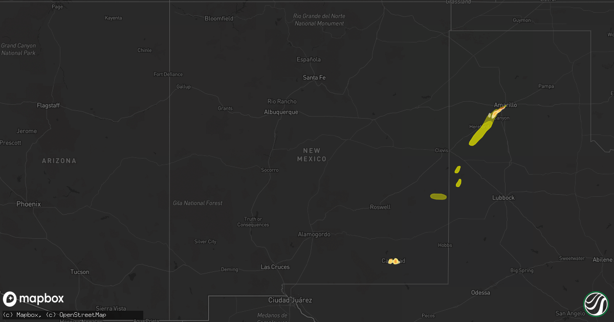
Hail Map in New Mexico on June 20, 2013
Get this storm
June 20 map
$229
one time, instant access
Download today. No call, no setup
Keep the $229
Bought the map and want the full workflow? Apply the entire $229 to a subscription within 7 days. None of it is wasted.
Every map, not just this one
This buys you this map. Subscription and you get every map we run, in the markets you choose from a few cities to whole states to nationwide. Plus real-time alerts the moment a storm fires.
Contact data
Name, contact info, occupancy, even credit band for addresses in the footprint. You go from where it hit to who to call.
Become the source they trust
Unlimited branding weather history reports on demand. You already have the documented answer ready for the property owner, and you are the one who showed up with it.
Property data and RoofTrace estimates
Pull up any address you have got, its value and the exact code rules for that jurisdiction, straight from One Click Code. Then RoofTrace estimates the squares, pitch, and roof value, priced the way you price.
Storm reports in New Mexico
New Mexico
| Date | Description |
|---|---|
| 06/20/20136:28 PM CDT | 5 power poles snapped near ground at highway 62/180 and w derrick road just east of airport. Time estimated based on asos gust time. |
| 06/20/20136:27 PM CDT | A local report indicates 67 MPH wind near 5 SSW CARLSBAD |
| 06/20/20136:10 PM CDT | On highway 62/180/ |
| 06/20/20135:13 PM CDT | A local report indicates 1.50 inch wind near CARLSBAD |
| 06/20/20135:05 PM CDT | A local report indicates 58 MPH wind near 2 SW DORA |
| 06/20/20134:35 PM CDT | Also pea to marble sized hail covering ground in south carlsbad. |
| 06/20/20134:05 PM CDT | A local report indicates 1.75 inch wind near 4 NW CARLSBAD |
| 06/20/20133:30 PM CDT | Quarter to golf ball sized hail |
All States Impacted by Hail Map on June 20, 2013
Cities Impacted by Hail Map on June 20, 2013
- Braham, MN
- Hancock, MN
- Appleton, MN
- Correll, MN
- Ashley, ND
- Linton, ND
- Lehr, ND
- Gackle, ND
- Wishek, ND
- Ottertail, MN
- Richville, MN
- Carlsbad, NM
- Rozet, WY
- Alberta, MN
- Morris, MN
- Tower City, ND
- Buffalo, ND
- Brook Park, MN
- Mora, MN
- Pine City, MN
- Grasston, MN
- Stanchfield, MN
- Ogilvie, MN
- Perham, MN
- Henning, MN
- Battle Lake, MN
- New York Mills, MN
- Hillsboro, ND
- Halstad, MN
- Hendrum, MN
- Muleshoe, TX
- Webster, SD
- Friona, TX
- Amarillo, TX
- Canyon, TX
- Valley City, ND
- Buffalo Center, IA
- Thompson, IA
- Forest City, IA
- Woden, IA
- Grantsburg, WI
- Siren, WI
- Page, ND
- Detroit Lakes, MN
- Grandin, ND
- Wildorado, TX
- Blanchard, ND
- Armstrong, IA
- Bancroft, IA
- Ringsted, IA
- Estherville, IA
- Swea City, IA
- Fenton, IA
- Dolliver, IA
- Chokio, MN
- Portland, ND
- Gwinner, ND
- Milnor, ND
- Forman, ND
- Titonka, IA
- Leland, IA
- Britt, IA
- Minong, WI
- Hope, ND
- Frazee, MN
- Rochert, MN
- Hawley, MN
- Winter, WI
- Ada, MN
- Fredonia, ND
- Eureka, SD
- Rogers, ND
- Enderlin, ND
- Harwood, ND
- Stewartville, MN
- Rochester, MN
- Colby, KS
- Hazelton, ND
- Braddock, ND
- Strasburg, ND
- Cogswell, ND
- Ledyard, IA
- Lake Park, MN
- Karlsruhe, ND
- Exeland, WI
- Ojibwa, WI
- Radisson, WI
- Couderay, WI
- Dent, MN
- Oriska, ND
- Sanborn, ND
- Lakota, IA
- Kintyre, ND
- Pecos, TX
- Tompkinsville, KY
- Celina, TN
- Red Boiling Springs, TN
- Hestand, KY
- Moss, TN
- Lone Rock, IA
- Rugby, ND
- Audubon, MN
- Pelican Rapids, MN
- Ortonville, MN
- Sabin, MN
- Wheatland, ND
- Granada, MN
- Danbury, WI
- Webster, WI
- Granville, ND
- Dumont, MN
- Graceville, MN
- Drake, ND
- Arcadia, WI
- Dodge, WI
- Long Lake, SD
- Underwood, MN
- Fingal, ND
- Donnelly, MN
- Esmond, ND
- Rothsay, MN
- Barnesville, MN
- Georgetown, MN
- Perley, MN
- Horace, ND
- Kindred, ND
- Fargo, ND
- Moorhead, MN
- West Fargo, ND
- Argusville, ND
- Voltaire, ND
- Sudan, TX
- Buffalo Valley, TN
- Silver Point, TN
- Deer Creek, MN
- Tatum, NM
- Crossroads, NM
- Milnesand, NM
- Elida, NM
- Napoleon, ND
- Zeeland, ND
- Sterling, ND
- Driscoll, ND
- Wing, ND
- Balfour, ND
- Hague, ND
- Pollock, SD
- Morton, TX
- Summerfield, TX
- Dimmitt, TX
- Hereford, TX
- Ashland City, TN
- Christine, ND
- Mayville, ND
- Clifford, ND
- Litchville, ND
- Marion, ND
- Ypsilanti, ND
- Spiritwood, ND
- Mapleton, ND
- Davenport, ND
- Sebeka, MN
- Menahga, MN
- Fergus Falls, MN
- Wolverton, MN
- Glyndon, MN
- Stone Lake, WI
- Ladysmith, WI
- Springbrook, WI
- Gordon, WI
- Hayward, WI


