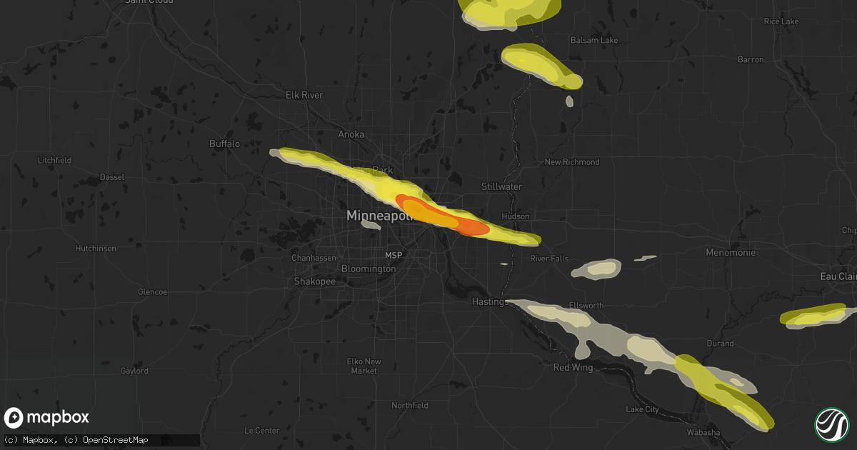
Hail Map in Saint Paul, MN on June 19, 2026
Get this storm
June 19 map
$229
one time, instant access
Download today. No call, no setup
Keep the $229
Bought the map and want the full workflow? Apply the entire $229 to a subscription within 7 days. None of it is wasted.
Every map, not just this one
This buys you this map. Subscription and you get every map we run, in the markets you choose from a few cities to whole states to nationwide. Plus real-time alerts the moment a storm fires.
Contact data
Name, contact info, occupancy, even credit band for addresses in the footprint. You go from where it hit to who to call.
Become the source they trust
Unlimited branding weather history reports on demand. You already have the documented answer ready for the property owner, and you are the one who showed up with it.
Property data and RoofTrace estimates
Pull up any address you have got, its value and the exact code rules for that jurisdiction, straight from One Click Code. Then RoofTrace estimates the squares, pitch, and roof value, priced the way you price.
Storm reports in Saint Paul, MN
Saint Paul, MN
| Date | Description |
|---|---|
| 06/19/20266:05 PM CDT | Photo report of hail slightly larger than 2 inches in st paul. |
| 06/19/20266:02 PM CDT | A local report indicates 1.25 inch wind near 2 S Oakdale |
| 06/19/20266:00 PM CDT | A local report indicates 1.25 inch wind near 2 W Maplewood |
| 06/19/20265:59 PM CDT | A local report indicates 1.25 inch wind near 1 E Roseville |
| 06/19/20265:54 PM CDT | Photo report via facebook. |
| 06/19/20265:51 PM CDT | A local report indicates 1.25 inch wind near Oakdale |
| 06/19/20265:47 PM CDT | A local report indicates 1.00 inch wind near Oakdale |
| 06/19/20265:44 PM CDT | Report from mping: quarter |
| 06/19/20265:44 PM CDT | A lot of hail near lake phalen... Up to quarter sized. |
| 06/19/20265:42 PM CDT | Photo report via facebook. |
| 06/19/20265:41 PM CDT | A local report indicates 1.25 inch wind near 2 W Maplewood |
| 06/19/20265:39 PM CDT | Report from mping: ping pong ball |
| 06/19/20265:37 PM CDT | Report from mping: half dollar |
| 06/19/20265:37 PM CDT | Report from mping: quarter |
| 06/19/20265:37 PM CDT | A local report indicates 1.00 inch wind near 1 E Roseville |
| 06/19/20265:36 PM CDT | Report from mping: quarter |
| 06/19/20265:36 PM CDT | Report from mping: quarter |
| 06/19/20265:35 PM CDT | A local report indicates 2.00 inch wind near 1 NE Falcon Heights |
| 06/19/20265:34 PM CDT | Report from mping: quarter |
| 06/19/20265:32 PM CDT | Golf ball sized hail near hwy 36 and i35. |
| 06/19/20265:32 PM CDT | Report from mping: quarter |
| 06/19/20265:32 PM CDT | Report from mping: hen egg |
| 06/19/20265:31 PM CDT | Photo report via facebook. |
| 06/19/20265:30 PM CDT | A local report indicates 1.50 inch wind near 2 SE Roseville |
| 06/19/20265:30 PM CDT | Report from mping: quarter |
| 06/19/20265:30 PM CDT | Photo report of half dollar sized hail. |
| 06/19/20265:29 PM CDT | Report from mping: golf ball |
| 06/19/20265:28 PM CDT | A lot of hail falling in roseville up to half dollar sized. The ground is fully covered with hail. |
| 06/19/20265:27 PM CDT | Report from mping: half dollar |
| 06/19/20265:26 PM CDT | Report from mping: quarter |
| 06/19/20265:23 PM CDT | Report from mping: quarter |
| 06/19/20265:23 PM CDT | A local report indicates 1.00 inch wind near Roseville |
All States Impacted by Hail Map on June 19, 2026
All Cities Impacted by Hail Map on June 19, 2026
- Anna, TX
- Eldorado, TX
- San Angelo, TX
- Lone Grove, OK
- Ardmore, OK
- Whitewright, TX
- Girard, TX
- Vancourt, TX
- Comanche, TX
- Farmersville, TX
- Snyder, TX
- Menard, TX
- Miles, TX
- Wall, TX
- Dallas, TX
- Paris, TX
- Paint Rock, TX
- Paducah, TX
- Eola, TX
- Campbell, TX
- Mill Creek, OK
- Greenville, TX
- Arthur City, TX
- Cooper, TX
- Powderly, TX
- Sumner, TX
- Brookston, TX
- De Kalb, TX
- Lake Creek, TX
- Enloe, TX
- Richland Springs, TX
- Pattonville, TX
- Deport, TX
- San Saba, TX
- Clarksville, TX
- Sulphur Bluff, TX
- Brady, TX
- Lohn, TX
- Coleman, TX
- Rochelle, TX
- Gustine, TX
- Avery, TX
- Doole, TX
- Millersview, TX
- Gouldbusk, TX
- Mount Vernon, TX
- Cherokee, TX
- Talpa, TX
- Annona, TX
- Valley Spring, TX
- Llano, TX
- Bend, TX
- Hooks, TX
- Goldthwaite, TX
- Lometa, TX
- Haworth, OK
- Melvin, TX
- New Boston, TX
- Ashdown, AR
- Foreman, AR
- Texarkana, AR
- Sanborn, NY
- Lockport, NY
- Dozier, AL
- Gasport, NY
- Akron, NY
- Sacramento, NM
- Marianna, FL
- Grand Ridge, FL
- Greenwood, FL
- Lake Mary, FL
- North Tonawanda, NY
- Brewton, AL
- Sanford, FL
- Hawley, MN
- Glyndon, MN
- Andalusia, AL
- Baker, FL
- Wing, AL
- Evergreen, AL
- Lake Wales, FL
- Brainerd, MN
- Edgewater, FL
- Oak Hill, FL
- Punta Gorda, FL
- Little River, AL
- Frazee, MN
- New Smyrna Beach, FL
- Chunchula, AL
- Citronelle, AL
- Chester, TX
- Georgetown, MN
- Uriah, AL
- Hillman, MN
- Pierz, MN
- Barnesville, MN
- Felton, MN
- Moorhead, MN
- Las Vegas, NM
- Verndale, MN
- Sebeka, MN
- Onamia, MN
- Staples, MN
- Cloudcroft, NM
- Kenansville, FL
- Stuttgart, AR
- Saint Cloud, FL
- Mescalero, NM
- Motley, MN
- Hondo, NM
- San Patricio, NM
- Pillager, MN
- Indian Lake Estates, FL
- Frostproof, FL
- Wagarville, AL
- Jackson, AL
- Okeechobee, FL
- Ogilvie, MN
- Milaca, MN
- Mora, MN
- Vero Beach, FL
- Duncan, MS
- Lake Placid, FL
- Mora, NM
- Aldrich, MN
- Tinnie, NM
- Franklin, TX
- Ocate, NM
- Palm Bay, FL
- Brenham, TX
- Moore Haven, FL
- Cushing, MN
- Cocoa, FL
- Alligator, MS
- Wahkon, MN
- Ribera, NM
- San Jose, NM
- Fort Ripley, MN
- Holcomb, MS
- Frankville, AL
- Bellville, TX
- Little Falls, MN
- Lorida, FL
- Braham, MN
- Cleveland, TX
- McLain, MS
- Neely, MS
- Leakesville, MS
- Blue Ridge, TX
- Grasston, MN
- Pine City, MN
- Rush City, MN
- Tutwiler, MS
- Charleston, MS
- Dayton, TX
- Sierra Blanca, TX
- Merritt Island, FL
- Saint Stephens, AL
- Chatom, AL
- Colfax, LA
- Virginia City, NV
- Olla, LA
- Jena, LA
- Trout, LA
- Chappell Hill, TX
- Silver Springs, NV
- Cypress, TX
- Reno, NV
- Hanover, MN
- Rogers, MN
- Loretto, MN
- Hamel, MN
- Grantsburg, WI
- Stanchfield, MN
- Tibbie, AL
- Dayton, NV
- Maple Grove, MN
- Osseo, MN
- Harris, MN
- Minneapolis, MN
- Raton, NM
- Cimarron, NM
- Geneva, FL
- Sparks, NV
- Mims, FL
- Osteen, FL
- Sylvan Grove, KS
- Buffalo, MN
- Lincoln, KS
- Saint Paul, MN
- North Branch, MN
- Saint Croix Falls, WI
- Ellsworth, KS
- Fruitdale, AL
- Cambridge, MN
- Deer Park, AL
- Clewiston, FL
- Cushing, WI
- Taylors Falls, MN
- Center City, MN
- Lindstrom, MN
- Vaughn, NM
- Salina, KS
- Brookville, KS
- New Caney, TX
- La Loma, NM
- Spring, TX
- Luck, WI
- Lake Elmo, MN
- Shafer, MN
- Anton Chico, NM
- Falun, KS
- Lindsborg, KS
- Assaria, KS
- South Bay, FL
- Mondovi, WI
- Coffeeville, MS
- Wellington, NV
- Eau Claire, WI
- Porter, TX
- Humble, TX
- Houston, TX
- Dresser, WI
- Stillwater, MN
- Afton, MN
- Osceola, WI
- Lakeland, MN
- Coila, MS
- Centuria, WI
- Belle Glade, FL
- Canal Point, FL
- Taylorsville, MS
- Carrollton, MS
- Amery, WI
- Hudson, WI
- River Falls, WI
- Utica, MS
- Hope, KS
- Prescott, WI
- Hager City, WI
- Fall Creek, WI
- Tampa, KS
- Gypsum, KS
- Ellsworth, WI
- Soso, MS
- Laurel, MS
- Stringer, MS
- Calhoun City, MS
- Pahokee, FL
- Oakman, AL
- Augusta, WI
- Boyd, WI
- Huffman, TX
- Spring Valley, WI
- Beldenville, WI
- Kingwood, TX
- Crosby, TX
- Loxahatchee, FL
- Galva, KS
- French Camp, MS
- Kilmichael, MS
- New Orleans, LA
- Stanley, WI
- Osseo, WI
- Fairchild, WI
- Bay City, WI
- Maiden Rock, WI
- Minden, NV
- Mathiston, MS
- Maben, MS
- Woodville, WI
- Eupora, MS
- Kokomo, MS
- Ellisville, MS
- Plum City, WI
- Starkville, MS
- Ovett, MS
- Sturgis, MS
- Durand, WI
- Hastings, MN
- Mize, MS
- Arkansaw, WI
- Baton Rouge, LA
- Eleva, WI
- Santa Rosa, NM
- Canton, KS
- Hillsboro, KS
- Moundridge, KS
- Goessel, KS
- Newton, KS
- Walton, KS
- Hesston, KS
- Peabody, KS
- Marion, KS
- Florence, KS
- Halstead, KS
- North Newton, KS
- Elbing, KS
- Burns, KS
- Whitewater, KS
- Alma Center, WI
- Humbird, WI
- Merrillan, WI
- Valley Center, KS
- Sedgwick, KS
- Potwin, KS
- Pepin, WI
- Richton, MS
- Foxworth, MS
- Nelson, WI
- Alma, WI
- Stockholm, WI
- Columbia, MS
- El Dorado, KS
- Towanda, KS
- Cornell, WI
- Brooksville, MS
- Oak Vale, MS
- Baker, LA
- Greenwell Springs, LA
- Cassoday, KS
- Wiggins, MS
- Jayess, MS
- Walker, LA
- Taiban, NM
- Fort Sumner, NM
- Lumberton, MS
- Denham Springs, LA
- Arcadia, WI
- Perkinston, MS
- Livingston, LA
- Laredo, TX
- Lecompte, LA
- Forest Hill, LA
- Cheneyville, LA
- Galesville, WI
- Ettrick, WI
- Mount Olive, MS
- Collins, MS
- Purvis, MS
- Floyd, NM
- Holden, LA
- San Ygnacio, TX
- Springfield, LA
- Tylertown, MS
- Angie, LA
- Hebbronville, TX
- Poplarville, MS
- Asherton, TX
- Big Wells, TX
- Crystal City, TX
- Freer, TX
- Realitos, TX
- Gibsland, LA
- Elkhart, TX
- Leander, TX
- Palestine, TX
- Rusk, TX
- Calhoun, LA
- Choudrant, LA
- Eros, LA
- Groesbeck, TX
- Kensington, KS
- Agra, KS
- Naponee, NE
- Phillipsburg, KS
- Republican City, NE
- Smith Center, KS
- Bonita, LA
- Bienville, LA
- Castor, LA
- Centerville, TX


