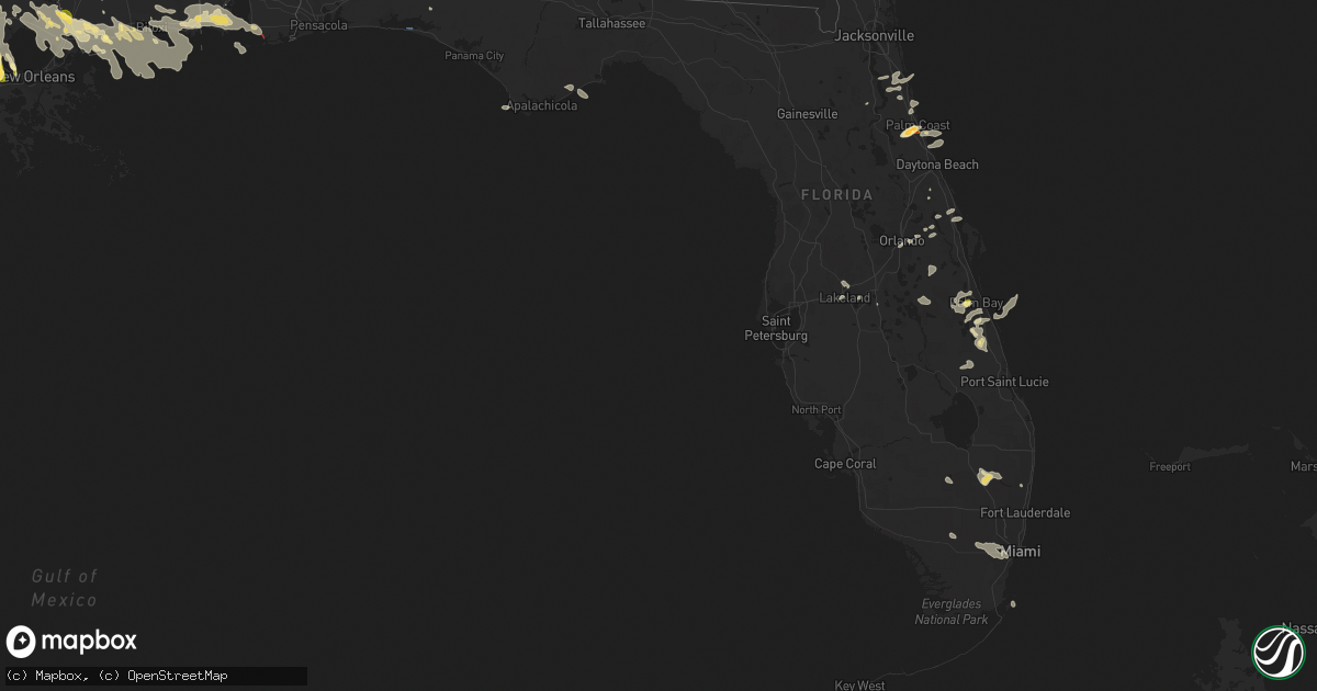
Hail Map in Florida on June 19, 2023
Get this storm
June 19 map
$229
one time, instant access
Download today. No call, no setup
Keep the $229
Bought the map and want the full workflow? Apply the entire $229 to a subscription within 7 days. None of it is wasted.
Every map, not just this one
This buys you this map. Subscription and you get every map we run, in the markets you choose from a few cities to whole states to nationwide. Plus real-time alerts the moment a storm fires.
Contact data
Name, contact info, occupancy, even credit band for addresses in the footprint. You go from where it hit to who to call.
Become the source they trust
Unlimited branding weather history reports on demand. You already have the documented answer ready for the property owner, and you are the one who showed up with it.
Property data and RoofTrace estimates
Pull up any address you have got, its value and the exact code rules for that jurisdiction, straight from One Click Code. Then RoofTrace estimates the squares, pitch, and roof value, priced the way you price.
Storm reports in Florida
Florida
| Date | Description |
|---|---|
| 06/19/20236:50 PM CDT | All lanes are obstructed by debris at 5000 palm coast parkway near hammock dunes bridge. Nearby hammock dunes bridge gusted to 57 mph. |
| 06/19/20236:50 PM CDT | Report of fence down caused by tstm wind. |
| 06/19/20236:45 PM CDT | Golfball... 1.75 inch hail... Reported. |
| 06/19/20236:43 PM CDT | Corrects previous hail report from 3 ene bunnell. Golfball... 1.75 inch hail... Reported at palm coast fire department station 21 belle terre parkway and palm coast par |
| 06/19/20235:46 PM CDT | Report of powerlin |
| 06/19/20235:46 PM CDT | Report of powerlines and trees down from thunderstorm wind gust. |
| 06/19/20232:45 PM CDT | Power lines down and large tree branches snapped. |
| 06/19/20232:39 PM CDT | Social media video showing a large tree down partially blocking traffic on north kendall drive near sw 112th avenue. This damage is associated with a severe thunderstor |
| 06/19/20232:30 PM CDT | Large tree branches snapped. Time estimated from radar. |
| 06/19/20232:21 PM CDT | Asos station kmia miami reported a wind gust of 59mph at 3:21pm as a severe thunderstorm moved through the area. |
| 06/19/20232:05 PM CDT | Corrects time from previous tstm wnd dmg report from 1 ene coral way village. Power lines down and large tree branches snapped. |
| 06/19/202311:26 AM CDT | A tree fell across hwy 17 near the blue bridge on the camden county side. Time was estimated by radar. |
| 06/19/202311:21 AM CDT | Multiple broadcast and social media reports of a tornado near sandestiin. |
| 06/19/202311:09 AM CDT | Power outage caused by fallen tree or limbs. |
| 06/19/20239:59 AM CDT | Corrects previous tstm wnd dmg report from 6 nne houston. Report of powerlines and trees down along cr 136a and 53rd road from thunderstorm wind gust. |
| 06/19/20239:20 AM CDT | Tree down on house on waukeenah st in moneticello. Time estimated by radar. |
| 06/19/20239:20 AM CDT | Several trees and power lines down across the county. |
| 06/19/20239:04 AM CDT | Tree down along i-10 reported on the florida highway patrol website. |
| 06/19/20239:00 AM CDT | Tree go through a modular home north of monticello... Fl. Time estimated by radar. |
| 06/19/20239:00 AM CDT | Tree down on powerlines along buck lake road... Just east of walden road. |
| 06/19/20239:00 AM CDT | Tree debris in road in 2300 block of centerville road. |
| 06/19/20238:55 AM CDT | Tree blocking road on salt road near ashville hwy and government farms road. |
| 06/19/20238:51 AM CDT | Tree down with powerlines on roadway at mahan and james ct. |
| 06/19/20238:50 AM CDT | Tree down across mahan at phillips. |
| 06/19/20236:40 AM CDT | A tree is down blocking the right lane of i-75 sb in reddick. Photo was relayed via social media. Time was estimated by radar. |
| 06/19/20234:43 AM CDT | Time estimated by radar. Gainesville pd advises that one northbound lane of sr-121 is closed at radio road in gainesville due to a downed tree. |
| 06/18/20239:12 PM CDT | Patrick space force base |
| 06/18/20238:50 PM CDT | Several public reports of damage... Including wires and a fence blown down... A metal shed blown over a fence and into a neighbor's yard... A pool enclosure damaged on |
| 06/18/20237:15 PM CDT | Trained spotter measured & photographed half dollar sized hail on hinchman street se. |
| 06/18/20237:05 PM CDT | Spotter reports quarter-sized hail in palm bay. |
| 06/18/20237:00 PM CDT | Tree down at the intersection of colbert lane at n village parkway. |
All States Impacted by Hail Map on June 19, 2023
Cities Impacted by Hail Map on June 19, 2023
- Laceys Spring, AL
- Huntsville, AL
- Owens Cross Roads, AL
- New Hope, AL
- Gurley, AL
- Woodville, AL
- Paint Rock, AL
- Scottsboro, AL
- Columbia, MS
- Miramar Beach, FL
- Santa Rosa Beach, FL
- Fairhope, AL
- Foley, AL
- Taft, TX
- Grand Bay, AL
- Carrabelle, FL
- Lumberton, MS
- Freeport, FL
- Brewton, AL
- Chipley, FL
- Cameron, SC
- Orangeburg, SC
- Perkinston, MS
- Doerun, GA
- Camilla, GA
- Sale City, GA
- Moultrie, GA
- Hartsfield, GA
- McHenry, MS
- Caryville, FL
- Bonifay, FL
- Coden, AL
- Theodore, AL
- Irvington, AL
- Moss Point, MS
- Elloree, SC
- Wiggins, MS
- Bowman, SC
- Amissville, VA
- Brady, TX
- Menard, TX
- Melvin, TX
- Eden, TX
- Hext, TX
- Mason, TX
- Lohn, TX
- Doole, TX
- Gouldbusk, TX
- Junction, TX
- London, TX
- Rockwood, TX
- Santa Anna, TX
- Rochelle, TX
- Christoval, TX
- San Angelo, TX
- Brookesmith, TX
- Vancleave, MS
- Camden, AL
- McIntosh, AL
- Citronelle, AL
- Chatom, AL
- Saraland, AL
- Chunchula, AL
- Lucedale, MS
- Jackson, AL
- Frankville, AL
- Saint Stephens, AL
- Deer Park, AL
- Lower Peach Tree, AL
- Wilmer, AL
- Mobile, AL
- Key Largo, FL
- Pine Hill, AL
- Atmore, AL
- Perdido, AL
- Alberta, AL
- Gautier, MS
- Ocean Springs, MS
- Semmes, AL
- Gulf Shores, AL
- Arlington, AL
- Thomaston, AL
- Waveland, MS
- Bay Saint Louis, MS
- Grove Hill, AL
- Thomasville, AL
- Millry, AL
- Miami, FL
- Gulfport, MS
- Wagarville, AL
- Tibbie, AL
- Port Saint Joe, FL
- Boca Raton, FL
- Saucier, MS
- Dickinson, AL
- Monroeville, AL
- Bayou La Batre, AL
- Pascagoula, MS
- Pass Christian, MS
- Biloxi, MS
- Diberville, MS
- Coleman, TX
- Bunnell, FL
- Palm Coast, FL
- Palm Bay, FL
- Bangs, TX
- Volborg, MT
- Ismay, MT
- Plevna, MT
- Picayune, MS
- Pearl River, LA
- Baker, MT
- Wibaux, MT
- Golva, ND
- Sentinel Butte, ND
- Cross Plains, TX
- Burkett, TX
- Leakesville, MS
- Kiln, MS
- Diamondhead, MS
- Saint Augustine, FL
- Elkton, FL
- Flagler Beach, FL
- Clyde, TX
- Fellsmere, FL
- Oviedo, FL
- Clewiston, FL
- Orlando, FL
- Mims, FL
- Saint Cloud, FL
- Kenansville, FL
- Oak Hill, FL
- Auburndale, FL
- Winter Haven, FL
- Mount Hermon, LA
- Osyka, MS
- Lakeland, FL
- Vero Beach, FL
- Tylertown, MS
- Jayess, MS
- Franklinton, LA
- Summerville, SC
- Sandy Hook, MS
- Angie, LA
- Mullin, TX
- Long Beach, MS
- Brooklyn, MS
- Hattiesburg, MS
- Eldorado, TX
- Eight Mile, AL
- Poplarville, MS
- Covington, LA
- Grant, FL
- Malabar, FL
- Vinegar Bend, AL
- Forsyth, MT
- Slidell, LA
- Palatka, FL
- Stennis Space Center, MS
- Vancourt, TX
- Foxworth, MS
- Purvis, MS
- Ormond Beach, FL
- New Smyrna Beach, FL
- Sebastian, FL
- Bogalusa, LA
- Lake Wales, FL
- Waverly, FL
- Hastings, FL
- Ponte Vedra Beach, FL
- Melbourne, FL
- Christmas, FL
- Melbourne Beach, FL
- Malta, MT
- Summit, MS
- Mccomb, MS
- Bush, LA
- Pearlington, MS
- Lacombe, LA
- Abita Springs, LA
- Lodge Grass, MT
- Garryowen, MT
- Crow Agency, MT
- Hardin, MT
- Angela, MT
- Cohagen, MT
- Kinsey, MT
- Terry, MT
- La Place, LA
- Norco, LA
- Hahnville, LA
- Destrehan, LA
- Boutte, LA
- Paradis, LA
- Luling, LA
- Rosebud, MT
- Hathaway, MT
- Miles City, MT
- Holden, LA
- Albany, LA
- Hammond, LA
- Springfield, LA
- Ponchatoula, LA
- Tickfaw, LA
- Lambert, MT
- Richey, MT
- Bloomfield, MT
- Circle, MT
- Lovell, WY
- Amite, LA
- Independence, LA
- Kenner, LA
- Brockway, MT
- Medora, ND
- Belfield, ND
- Loranger, LA
- Okeechobee, FL
- Fort Pierce, FL
- Saint Xavier, MT
- Pine Grove, LA
- Robert, LA
- Walker, LA
- Clinton, LA
- Denham Springs, LA
- Greenwell Springs, LA
- New Orleans, LA
- Folsom, LA
- Mandeville, LA
- Madisonville, LA
- Limon, CO
- Fayette, MS
- Roxie, MS
- Natchez, MS
- Williston, ND
- Colstrip, MT
- Busby, MT
- Lindsay, MT
- Sinton, TX
- Woodsboro, TX


