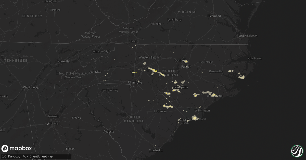
Hail Map in North Carolina on June 19, 2015
Get this storm
June 19 map
$229
one time, instant access
Download today. No call, no setup
Keep the $229
Bought the map and want the full workflow? Apply the entire $229 to a subscription within 7 days. None of it is wasted.
Every map, not just this one
This buys you this map. Subscription and you get every map we run, in the markets you choose from a few cities to whole states to nationwide. Plus real-time alerts the moment a storm fires.
Contact data
Name, contact info, occupancy, even credit band for addresses in the footprint. You go from where it hit to who to call.
Become the source they trust
Unlimited branding weather history reports on demand. You already have the documented answer ready for the property owner, and you are the one who showed up with it.
Property data and RoofTrace estimates
Pull up any address you have got, its value and the exact code rules for that jurisdiction, straight from One Click Code. Then RoofTrace estimates the squares, pitch, and roof value, priced the way you price.
Storm reports in North Carolina
North Carolina
| Date | Description |
|---|---|
| 06/19/20156:56 PM CDT | Several trees reported down on raeford road... Time estimated by radar |
| 06/19/20156:55 PM CDT | A local report indicates 1.00 inch wind near BROOKVIEW ESTATES |
| 06/19/20156:55 PM CDT | Tree down... Time estimated by radar |
| 06/19/20156:55 PM CDT | Tree down... Time estimated by radar |
| 06/19/20156:55 PM CDT | Tree down... Time estimated by radar |
| 06/19/20156:50 PM CDT | Tree down... Time estimated by radar |
| 06/19/20156:48 PM CDT | Power line down... Time estimated by radar |
| 06/19/20156:48 PM CDT | Power line down... Time estimated by radar |
| 06/19/20156:32 PM CDT | Part of roof blown off a car dealership damaging a few cars. Time estimated based off radar. |
| 06/19/20155:50 PM CDT | Onslow 911 center reports nickel to quarter size hail at their location. Public reports via media of 1 inch hail as well. |
| 06/19/20155:48 PM CDT | Social media report of quarter-size hail in jacksonville. |
| 06/19/20154:45 PM CDT | Tree down at arnold road... Time estimated by radar |
| 06/19/20154:40 PM CDT | One tree down and large limbs down on power lines. |
| 06/19/20154:22 PM CDT | Several trees down near where highway 64 crosses over into davidson county. |
| 06/19/20154:20 PM CDT | Tin roofing ripped off barn. A few trees snapped off in woods. Many branches also down...some 6-8 inches in diameter. |
| 06/19/20154:15 PM CDT | Large hickory tree down along parkton-tobermory rd near thumper rd. |
| 06/19/20153:55 PM CDT | Metal and wood roof blown off a business... Limbs 2 inches in diameter down... Time estimated by radar |
| 06/19/20153:53 PM CDT | At least 6 trees down in salisbury with one falling on a railroad track near the amtrak station. |
| 06/19/20153:50 PM CDT | Many trees down at the intersection of sherrills ford road and highway 150. |
| 06/19/20153:40 PM CDT | Tree down in grays greek... Time estimated by radar |
| 06/19/20153:39 PM CDT | Trees and power lines down on neel rd. |
| 06/19/20153:27 PM CDT | Trees down. |
| 06/19/20153:22 PM CDT | Two trees down. |
| 06/19/20153:13 PM CDT | Trees down at intersection of highway 21 and huntington road. |
| 06/19/20153:07 PM CDT | Report of quarter sized hail along brawley school road. |
| 06/19/20152:37 PM CDT | Quarter size hail reported at nc hwy 49 and brantley gordon rd... Time estimated by radar |
| 06/19/20152:28 PM CDT | Many tree branches blown down with at least a few of them being at least 2 inches in diameter. |
| 06/19/20152:28 PM CDT | 3 feet diameter tree on rutherford college down and post office signs bent to 45 degree angle. Exit 114 off interstate 40...many tree limbs of 2 to 3 inches diameter do |
| 06/19/20151:15 PM CDT | A few isolated trees down along polly spout rd. Also small hail in vein mountain community. |
| 06/18/20157:58 PM CDT | Several trees blown down along central street |
| 06/18/20157:26 PM CDT | Trees down at mile marker 1 interstate 85 northbound. |
| 06/18/20157:05 PM CDT | Trees down... Time estimated by radar |
| 06/18/20157:03 PM CDT | Tree down... Time estimated by radar |
| 06/18/20157:00 PM CDT | Tree down... Time estimated by radar |
| 06/18/20157:00 PM CDT | Tree down... Time estimated by radar |
All States Impacted by Hail Map on June 19, 2015
Cities Impacted by Hail Map on June 19, 2015
- Larslan, MT
- Bunnell, FL
- Seville, FL
- Lame Deer, MT
- Birney, MT
- Ramona, SD
- Trent, SD
- Garretson, SD
- Baltic, SD
- Dell Rapids, SD
- Chester, SD
- Wentworth, SD
- Madison, SD
- Colman, SD
- Wall, SD
- Watford City, ND
- Killdeer, ND
- Grassy Butte, ND
- Saco, MT
- Denton, NC
- Mandan, ND
- New Salem, ND
- Center, ND
- Maxton, NC
- Wagram, NC
- Laurinburg, NC
- Latta, SC
- Blenheim, SC
- Glen Ullin, ND
- Woolstock, IA
- Clarion, IA
- Cartwright, ND
- Wessington, SD
- Saint Lawrence, SD
- Steen, MN
- Magnolia, MN
- Kanaranzi, MN
- Luverne, MN
- Rock Rapids, IA
- Beaver Creek, MN
- Ellsworth, MN
- Whitewater, MT
- Hinsdale, MT
- Volborg, MT
- Glendive, MT
- Blairsburg, IA
- Jacksonville, FL
- Vale, SD
- Little Rock, IA
- Adrian, MN
- Valley Springs, SD
- Peerless, MT
- Poplar, MT
- Wolf Point, MT
- McBee, SC
- Cloudcroft, NM
- Wauchula, FL
- Hill City, SD
- De Smet, SD
- Iroquois, SD
- Floyd, VA
- Ashland, MT
- Claunch, NM
- Fort Pierre, SD
- Moorcroft, WY
- Dillon, SC
- Headrick, OK
- Fulda, MN
- Avoca, MN
- Newell, SD
- Billings, MT
- Lake Wales, FL
- Bartow, FL
- English, IN
- Branchville, IN
- Leopold, IN
- Leavenworth, IN
- Sulphur, IN
- Amboy, MN
- Bismarck, ND
- Rushmore, MN
- Crow Agency, MT
- Scarville, IA
- Thompson, IA
- Lake Mills, IA
- Emmons, MN
- Leland, IA
- Kiester, MN
- Rapid City, SD
- Keystone, SD
- Newcastle, WY
- Slayton, MN
- Currie, MN
- Lake Wilson, MN
- Onida, SD
- Blunt, SD
- Solen, ND
- Kadoka, SD
- Fairview, MT
- Orient, SD
- Bowman, ND
- Woodbine, GA
- Kingsland, GA
- Hamer, SC
- Saint Marys, GA
- Albert City, IA
- Whittemore, IA
- Cylinder, IA
- Marathon, IA
- West Bend, IA
- Rembrandt, IA
- Rolfe, IA
- Laurens, IA
- Havelock, IA
- Curlew, IA
- Webb, IA
- Plover, IA
- Mallard, IA
- Emmetsburg, IA
- Wibaux, MT
- Hulett, WY
- Ruidoso, NM
- Fayetteville, NC
- Delco, NC
- Leland, NC
- Riegelwood, NC
- Burlington, NC
- Miller, SD
- Liberty, TN
- Fort Pierce, FL
- Otter, MT
- Busby, MT
- Garryowen, MT
- Orlando, FL
- Shallotte, NC
- Supply, NC
- Bolivia, NC
- Oak Island, NC
- Powell, TN
- Sundance, WY
- Alexander, ND
- Mooresville, NC
- Belle Fourche, SD
- Nisland, SD
- Cosby, TN
- Sevierville, TN
- Trementina, NM
- Holabird, SD
- Culbertson, MT
- Parkton, NC
- Hope Mills, NC
- Pantego, NC
- Oldham, SD
- Quinn, SD
- Miles City, MT
- Lovington, NM
- Ona, FL
- Halliday, ND
- Fairmont, MN
- Granada, MN
- Spearfish, SD
- Saint Onge, SD
- Corona, NM
- Hitchcock, SD
- Tulare, SD
- Snyder, OK
- Aladdin, WY
- Beulah, WY
- Whitewood, SD
- Grandview, IN
- Lamar, IN
- Evanston, IN
- Yale, SD
- Huron, SD
- Kanawha, IA
- Hardwick, MN
- Hermosa, SD
- Custer, SD
- Caputa, SD
- Shannon, NC
- Raeford, NC
- Philip, SD
- Sidney, MT
- Lexington, NC
- Asheboro, NC
- Magnolia, NC
- Mountain Park, OK
- Saint Cloud, FL
- Pierre, SD
- Heron Lake, MN
- Kamrar, IA
- Webster City, IA
- Fallon, MT
- Northwood, IA
- Lambert, MT
- Howard, SD
- Tyler, MN
- Garvin, MN
- Balaton, MN
- Ruthton, MN
- Watertown, SD
- Henry, SD
- Clark, SD
- Toronto, SD
- Bradgate, IA
- Gilmore City, IA
- Colstrip, MT
- Forsyth, MT
- Bloomfield, MT
- Lindsay, MT
- Presho, SD
- Winter Haven, FL
- Hebron, ND
- Richardton, ND
- Highmore, SD
- Waverly, GA
- Myakka City, FL
- Marston, NC
- Cache, OK
- Wasta, SD
- Greeneville, TN
- Wolsey, SD
- Chatham, VA
- Vero Beach, FL
- Kings Bay, GA
- Edgerton, MN
- Chandler, MN
- Laurel Hill, NC
- Linden, NC
- Salisbury, NC
- Everly, IA
- Spencer, IA
- Dickinson, ND
- Sturgis, SD
- Terry, MT
- Geronimo, OK
- Harrold, SD
- Charlotte, NC
- Brockton, MT
- Altamonte Springs, FL
- Casselberry, FL
- New Underwood, SD
- Mud Butte, SD
- Cooper, TX
- Cameron, NC
- Jackson, MN
- Lakefield, MN
- Marshall, MN
- Saint Xavier, MT
- Sanford, FL
- Magdalena, NM
- Alzada, MT
- Tracy, MN
- Rhame, ND
- Mebane, NC
- Vida, MT
- Dodge, ND
- Indiantown, FL
- Alva, WY
- Hammond, MT
- Okoboji, IA
- Milford, IA
- Spirit Lake, IA
- Redfield, SD
- Swanquarter, NC
- Engelhard, NC
- Oak Ridge, TN
- Terril, IA
- Ruthven, IA
- Graettinger, IA
- Jasper, MN
- Deadwood, SD
- Brewster, MN
- Jacksonville, NC
- Blue Earth, MN
- Fairfield, ND
- Cavour, SD
- Carthage, SD
- Ree Heights, SD
- Garland, NC
- Rose Hill, NC
- Harrells, NC
- Wallace, NC
- Hills, MN
- Lake Park, IA
- Harris, IA
- Arnegard, ND
- Dunn Center, ND
- Terrell, NC
- Sherrills Ford, NC
- Winter Park, FL
- Indiahoma, OK
- Alta, IA
- Altus, OK
- Kissimmee, FL
- Somerset, KY
- Labelle, FL
- Worthington, MN
- Round Lake, MN
- White, SD
- Goldfield, IA
- Titonka, IA
- Woden, IA
- Windom, MN
- Darien, GA
- Boyes, MT
- Colton, SD
- Hartford, SD
- Keldron, SD
- Belmond, IA
- Brunswick, GA
- Rozet, WY
- Weston, WY
- Gillette, WY
- Latimer, IA
- Beach, ND
- Broadus, MT
- Goodell, IA
- Platte, SD
- Lake View, SC
- Erwin, SD
- Collettsville, NC
- Flandreau, SD
- Estherville, IA
- Loring, MT
- Charleston, TN
- Mount Ulla, NC
- Red Springs, NC
- Lumber Bridge, NC
- Cohagen, MT
- Pierson, FL
- Wilmington, NC
- Meservey, IA
- Sheffield, IA
- Thornton, IA
- Alexander, IA
- Wesley, IA
- Pinehurst, NC
- Rutland, IA
- Ismay, MT
- Frost, MN
- Bricelyn, MN
- Salt Lick, KY
- Winfred, SD
- Egan, SD
- Rowan, IA
- Walters, OK
- Midland, SD
- Wessington Springs, SD
- Lake Benton, MN
- Frederick, OK
- Aredale, IA
- Dows, IA
- Garner, IA
- Klemme, IA
- Dougherty, IA
- Clear Lake, IA
- Greene, IA
- Hampton, IA
- Swaledale, IA
- Rockwell, IA
- Britt, IA
- Chapin, IA
- Draper, SD
- Trimont, MN
- Rowland, NC
- Walnut Grove, MN
- Cherry Creek, SD
- Wells, MN
- Elmore, MN
- Greenville, IA
- Faxon, OK
- Thomasville, AL
- Castlewood, SD
- Pooler, GA
- Savannah, GA
- Danvers, MN
- Fort Meade, FL
- Dupree, SD
- Ocheyedan, IA
- Holstein, IA
- Aurelia, IA
- Loveland, OK
- Hollister, OK
- Ekalaka, MT
- Conchas Dam, NM
- Kinsey, MT
- Sanford, NC
- Valdese, NC
- Hanlontown, IA
- Manly, IA
- Apopka, FL
- Gann Valley, SD
- George, IA
- Naples, FL
- Welcome, MN
- Felda, FL
- Immokalee, FL
- Seagrove, NC
- New London, NC
- Robbins, NC
- Troy, NC
- Midway Park, NC
- Tarawa Terrace, NC
- Camp Lejeune, NC
- Hubert, NC
- Sellers, SC
- Williston, ND
- Cherokee, IA
- Forest City, IA
- Beattyville, KY
- Raleigh, NC
- Durham, NC
- Wake Forest, NC
- Golden Valley, ND
- Beulah, ND
- Manning, ND
- Taylor, ND
- Gladstone, ND
- Bainville, MT
- Buffalo, SD
- Camp Crook, SD
- Troy, IN
- Tell City, IN
- Jeffers, MN
- Arnolds Park, IA
- East Palatka, FL
- San Mateo, FL
- Alpena, SD
- Erwin, NC
- Wade, NC
- Richlands, NC
- Kenansville, NC
- Chinquapin, NC
- Beulaville, NC
- Humboldt, IA
- Watertown, TN
- Fairfield, NC
- Rosebud, MT
- Glade Valley, NC
- Sherburn, MN
- Alto, NM
- Buffalo Center, IA
- Lucan, MN
- Wabasso, MN
- Renwick, IA
- Hardy, IA
- Hartley, IA
- Union Mills, NC
- Lowgap, NC
- Cordesville, SC
- Hampstead, NC
- Rocky Point, NC
- Clements, MN
- Lead, SD
- Brockway, MT
- Howes, SD
- Eagle Grove, IA
- Galt, IA
- Glasgow, MT
- Menoken, ND
- Hayes, SD
- Hazel, SD
- Milesville, SD
- Sibley, IA
- Doon, IA
- Devils Tower, WY
- Lake Mary, FL
- Mount Airy, NC
- Bowling Green, FL
- Loris, SC
- Conway, SC
- Owanka, SD
- Wrightsville Beach, NC
- Mullins, SC
- Ringsted, IA
- Fenton, IA
- Melvin, IA
- Willis, VA
- Alden, MN
- Fostoria, IA
- Corwith, IA
- Coulter, IA
- Mason City, IA
- Ventura, IA
- Lake Lure, NC
- Southport, NC
- Elkton, SD
- Cleveland, TN
- De Leon Springs, FL
- Milroy, MN
- Sulphur Springs, TX
- Carrizozo, NM
- Fort Bragg, NC
- Biddle, MT
- Winston, NM
- Caballo, NM
- Afton, TN
- Jefferson, SC
- Ashton, IA
- Pollocksville, NC
- Reading, MN
- Teachey, NC
- Clinton, NC
- Myrtle Beach, SC
- Oviedo, FL
- Westmoreland, TN
- Enning, SD
- Scenic, SD
- Tryon, NC
- Mill Spring, NC
- Honey Grove, TX
- Blairs, VA
- Okabena, MN
- Pocahontas, IA
- Plymouth, NC
- Baldwin, ND
- Regan, ND
- Wilton, ND
- Brookings, SD
- Aurora, SD
- Ocracoke, NC
- Longwood, FL
- Maitland, FL
- Ayrshire, IA
- Sioux Rapids, IA
- Gregory, SD
- Frazer, MT
- Tipton, OK
- Goose Creek, SC
- Columbus, NC
- Ottosen, IA
- Prospect Hill, NC
- Loxahatchee, FL
- Advance, NC
- Mocksville, NC
- Pawleys Island, SC
- Bigelow, MN
- Nemo, SD
- Black Hawk, SD
- Union Center, SD
- Lismore, MN
- Wilmont, MN
- Portland, TN
- Cottontown, TN
- Gallatin, TN
- Ledyard, IA
- Crescent City, FL
- Linn Grove, IA
- Superior, IA
- Dickens, IA
- Wallingford, IA
- Dakota City, IA
- Bode, IA
- Fonda, IA
- Livermore, IA
- Crane Lake, MN
- Heidelberg, MS
- Larchwood, IA
- Yulee, FL
- Folkston, GA
- White Oak, GA
- Dowelltown, TN
- Trenton, NC
- Willow Lake, SD
- Westbrook, MN
- Storden, MN
- Alpha, MN
- Fort Thompson, SD
- Vass, NC
- Whiteville, NC
- Carpenter, SD
- Chamberlain, SD
- McColl, SC
- Patrick, SC
- Lone Rock, IA
- Appleton, MN
- Holloway, MN
- Winter Springs, FL
- Spring Lake, NC
- Saint Pauls, NC
- Debary, FL
- Arlington, SD
- Bruce, SD
- Pipestone, MN
- Lake Norden, SD
- Hastings, FL
- Fremont, NC
- Dunn, NC
- Sunset Beach, NC
- North Myrtle Beach, SC
- Inwood, IA
- Alvord, IA
- Crooks, SD
- Renner, SD
- Chattanooga, OK
- Correll, MN
- Ortonville, MN
- Redwood Falls, MN
- Ladonia, TX
- Ferrum, VA
- Belhaven, NC
- Rutland, SD
- Maceo, KY
- Rockport, IN
- Lebanon, KY
- Trinidad, CO
- Lake City, SD
- Lakota, IA
- Malta, MT
- Hardin, MT
- Baker, MT
- Marmarth, ND
- Plevna, MT


