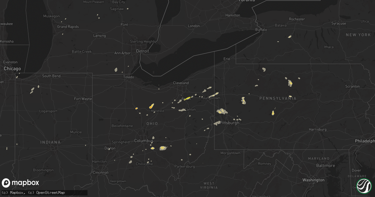
Hail Map on June 17, 2024
Get this storm
June 17 map
$229
one time, instant access
Download today. No call, no setup
Keep the $229
Bought the map and want the full workflow? Apply the entire $229 to a subscription within 7 days. None of it is wasted.
Every map, not just this one
This buys you this map. Subscription and you get every map we run, in the markets you choose from a few cities to whole states to nationwide. Plus real-time alerts the moment a storm fires.
Contact data
Name, contact info, occupancy, even credit band for addresses in the footprint. You go from where it hit to who to call.
Become the source they trust
Unlimited branding weather history reports on demand. You already have the documented answer ready for the property owner, and you are the one who showed up with it.
Property data and RoofTrace estimates
Pull up any address you have got, its value and the exact code rules for that jurisdiction, straight from One Click Code. Then RoofTrace estimates the squares, pitch, and roof value, priced the way you price.
States Impacted by Hail Map on June 17, 2024
Storm reports
Missouri
| Date | Description |
|---|---|
| 06/17/20241:48 PM CDT | Damage to the roof of a house and trees along mo 449 near old bethel baptist church. Time estimated with radar. |
Kentucky
| Date | Description |
|---|---|
| 06/17/20246:00 PM CDT | Breathitt county dispatch reported a couple of trees blown down about 7 miles up ky-378. |
| 06/17/20245:46 PM CDT | Leslie county dispatch reported a tree blown down on power lines near the intersection of river road and mcintosh road |
| 06/17/20245:33 PM CDT | A large tree split down the middle that fell on vehicles in the gateway townhomes parking lot. |
South Dakota
| Date | Description |
|---|---|
| 06/17/20243:20 AM CDT | Asos station kabr aberdeen rgnl ap. |
| 06/17/20242:11 AM CDT | Mesonet station 325 seneca |
| 06/17/20241:37 AM CDT | Mesonet station 212 agar |
| 06/17/20241:37 AM CDT | Mesonet station 216 bowdle |
| 06/17/202412:16 AM CDT | A local report indicates 60 MPH wind near 1 N Pollock |
Ohio
| Date | Description |
|---|---|
| 06/17/20246:30 PM CDT | Multiple trees and powerlines downed. |
| 06/17/20246:08 PM CDT | Corrects previous tstm wnd dmg r |
| 06/17/20246:08 PM CDT | Corrects previous tstm wnd dmg report from 3 nne shelby. Tree down on utility lines and in roadway. |
| 06/17/20246:08 PM CDT | Large branch down on utility lines. |
| 06/17/20246:05 PM CDT | Trees down and powerline damage. |
| 06/17/20245:58 PM CDT | Delayed report. |
| 06/17/20245:12 PM CDT | Mixed with smaller hail. |
| 06/17/20245:06 PM CDT | A local report indicates 1.00 inch wind near 1 S Magnolia |
| 06/17/20244:40 PM CDT | Boat dock road has power lines down. |
| 06/17/20244:40 PM CDT | Boat dock road has power |
| 06/17/20244:30 PM CDT | Trees down. |
| 06/17/20244:28 PM CDT | Trees down. |
| 06/17/20244:17 PM CDT | Trees down. |
| 06/17/20244:14 PM CDT | 3-inch tree limbs broken. |
| 06/17/20244:14 PM CDT | Trees down. |
| 06/17/20243:45 PM CDT | Multiple large... Healthy... Trees were downed. |
| 06/17/20243:44 PM CDT | Corrects previous tstm wnd dmg report from 2 ssw pataskala. Tree down on refugee rd near liberty christian academy. Time estimated from radar data. |
| 06/17/20243:41 PM CDT | Reports of large tree branches downed along with broken power poles. |
| 06/17/20243:26 PM CDT | Reports of multiple trees downed... Several that fell on top of structures and powerlines. |
| 06/17/20243:15 PM CDT | Several trees were downed along hough road. |
| 06/17/20243:06 PM CDT | Multiple uprooted trees. Time estimated via radar. |
| 06/17/20243:02 PM CDT | Trees and wires down at route 46 & brockway. Time estimated via radar. |
| 06/17/20242:53 PM CDT | Trees down on newark rd. |
| 06/17/20242:48 PM CDT | A tree was downed over st. Paul road. |
| 06/17/20242:45 PM CDT | Tree with wires down at sharrott and w western reserve rd. Power outages noted in the area. |
| 06/17/20242:35 PM CDT | Trees down in hanover township. Time estimated via radar. |
| 06/17/20242:35 PM CDT | Trees and branches down in winona. Time estimated via radar. |
| 06/17/20242:28 PM CDT | Tree limbs down on powerlines on route 304. |
| 06/17/20242:27 PM CDT | 3 inch diameter tree branches broken. |
| 06/17/20242:27 PM CDT | Trees down along logan way. |
| 06/17/20242:25 PM CDT | -delayed report- numerous trees and limbs downed in crandall park and the crandall neighborhood in northern youngstown. |
| 06/17/20242:25 PM CDT | Three branches from dead trees down between jasper mill and washington court house along us-22. The one in washington court house fell on a porch roof. Time estimated f |
| 06/17/20242:25 PM CDT | One inch diameter tree limbs were broken off. |
| 06/17/20242:15 PM CDT | Trumbull county dispatch reported numerous trees and power lines down across the southern portion of the county. There is also a power pole with lines on a truck in thi |
| 06/17/20242:14 PM CDT | Multiple trees reported down near state route 73. |
| 06/17/20242:10 PM CDT | Large tree limbs down. Time estimated via radar. |
| 06/17/20242:06 PM CDT | Large tree branches downed in carillon park. |
| 06/17/20242:05 PM CDT | Trees down in hanover township. Time estimated via radar. |
| 06/17/20242:05 PM CDT | Trees and branches down in winona. Time estimated via radar. |
| 06/17/20242:04 PM CDT | Large 7-8 inch in diameter tree branches down. |
| 06/17/20241:49 PM CDT | Tops blown off of at least 4 trees. |
| 06/17/20241:41 PM CDT | Eight inch diameter tree limbs downed along with a separate mature tree. |
| 06/17/20241:41 PM CDT | Tree down near intersection of e washington and hunt dr. Time estimated from radar. |
| 06/17/20241:41 PM CDT | Tree down near intersection of us-22w and clarksville rd. |
| 06/17/20241:28 PM CDT | Tree down on refugee rd near liberty christian academy. Time estimated from radar data. |
| 06/17/20241:24 PM CDT | Large tree snapped along north clarksville road. Time estimated by radar. |
| 06/17/20241:20 PM CDT | Dispatch reported a wire down on north center street... North of lagrange. |
| 06/17/20241:08 PM CDT | Photos of trees down near lincolnway nw and culverne nw on the west side of massillon. |
| 06/17/20241:04 PM CDT | Amateur radio report of 60 mph winds and measured hail of 1/4 to 3/8 in in lawrence township. |
| 06/17/20241:00 PM CDT | Tree damage in several locations between north lawrence and massillon. |
| 06/17/202412:59 PM CDT | Tree down on house and wires down. Time estimated via radar. |
| 06/17/202412:59 PM CDT | Tree down on house and wires down. Time estimated via radar. (c |
| 06/17/202412:59 PM CDT | Tree and wires down. Time estimated via radar. |
| 06/17/202412:52 PM CDT | Photos of several trees down in kent. |
| 06/17/202412:48 PM CDT | Also had tree down. |
| 06/17/202412:47 PM CDT | Tallmadge fire reports numerous trees and power lines down in tallmadge... Including munroe road and sr 261. About 4500 people without power. |
| 06/17/202412:45 PM CDT | A local report indicates 1.25 inch wind near 2 SW Tallmadge |
| 06/17/202412:05 PM CDT | Estimated 60-65 mph wind gust. |
| 06/17/202412:05 PM CDT | Amateur radio reports several trees down in fostoria. |
North Dakota
| Date | Description |
|---|---|
| 06/17/20242:20 AM CDT | Two center pivot irrigators were tipped over by thunderstorm wind gusts. Time estimated from radar. |
| 06/17/20242:20 AM CDT | Media broadcaster received a report of quarter sized hail in litchville...nd. |
| 06/17/20242:20 AM CDT | Multiple power poles were broken in the area due to severe thunderstorm wind gusts... Which led to power outages. |
| 06/17/20242:10 AM CDT | Reported by nddot station verona ess. |
| 06/17/20242:05 AM CDT | Public reported reported 67.3 mph wind gust off their weather station and shingles have been blown off the roof. |
| 06/17/20241:57 AM CDT | 67.3 mph wind gust observed on personal weather station. Shingle damage noted. Time estimated via radar. |
| 06/17/20241:50 AM CDT | Mesonet station 325489 2 s marion |
| 06/17/20241:47 AM CDT | 3 to 4 inch diameter tree branches broken. Time estimated from radar. |
| 06/17/20241:35 AM CDT | Tree damage. |
| 06/17/20241:30 AM CDT | Large trees blown down. |
| 06/17/20241:20 AM CDT | A local report indicates 60 MPH wind near Ypsilanti |
| 06/17/20241:15 AM CDT | Gobblers knob personal weather station. |
| 06/17/20241:10 AM CDT | Measured gust at logan center ndawn 33 ft sensor. |
| 06/17/20241:09 AM CDT | Asos station kjms jamestown airport. |
| 06/17/20241:07 AM CDT | Measured gust at dazey ndawn 10ft sensor. |
| 06/16/202410:29 PM CDT | Estimated 60 mph wind gusts. Wind and hail is ongoing at the time of the call. |
| 06/16/20249:50 PM CDT | Knife river raws site. |
| 06/16/20249:30 PM CDT | Estimated 60 to 70 mph gusts and pea sized hail. |
| 06/16/20249:30 PM CDT | Nddot site nd021. |
| 06/16/20249:04 PM CDT | Asos station kn60 garrison. |
Virginia
| Date | Description |
|---|---|
| 06/17/20246:56 PM CDT | Trees and powerlines down west of goodview. Note: reports received as of the end of the calendar day on june 17... 2024. |
| 06/17/20246:56 PM CDT | Trees and powerlines down west of goodview. |
West Virginia
| Date | Description |
|---|---|
| 06/17/20245:14 PM CDT | Damage to power lines on frankfort road |
| 06/17/20243:40 PM CDT | Trees down across the county. |
| 06/16/20247:47 PM CDT | Tree on power line. |
| 06/16/20247:40 PM CDT | Tree down on powerlines. |
| 06/16/20247:38 PM CDT | Tree down. |
Wyoming
| Date | Description |
|---|---|
| 06/16/20248:20 PM CDT | A local report indicates 1.25 inch wind near 1 NNE Hulett |
Pennsylvania
| Date | Description |
|---|---|
| 06/17/20246:21 PM CDT | Multiple trees knocked down in morris township. |
| 06/17/20246:09 PM CDT | Tree down ont |
| 06/17/20246:09 PM CDT | Tree down onto south kendall avenue blocking both lanes of traffic. |
| 06/17/20245:46 PM CDT | Trees down on unionville road |
| 06/17/20245:12 PM CDT | Wires and trees down. Damage from gust front. |
| 06/17/20245:00 PM CDT | Several trees snapped on wallace road |
| 06/17/20244:48 PM CDT | Tree down on seabright road and north branch road. |
| 06/17/20244:45 PM CDT | Wires down on morgan lane and thorne run road. |
| 06/17/20244:43 PM CDT | Tree down on berlin road and dogwood circle. |
| 06/17/20244:43 PM CDT | Wires down on steele road. |
| 06/17/20244:40 PM CDT | A number of trees and wires down around the jeannette region. |
| 06/17/20244:40 PM CDT | Wires down on kunkle road... Damage from the gust front. |
| 06/17/20244:40 PM CDT | A number of trees and power lines down in salem township. |
| 06/17/20244:40 PM CDT | Wires down on yellowknife street. |
| 06/17/20244:35 PM CDT | A number of trees and wires down in washington township. |
| 06/17/20244:35 PM CDT | Tree down on ridge road and myers lane. Damage from the gust front. |
| 06/17/20244:34 PM CDT | Numerous trees and wires down between murrysville and export. Roads impact were: cherry drive... Ringertown road... Wilson road... Virgina street... Silvis road... Hilt |
| 06/17/20244:33 PM CDT | Power lines down on shaffer road. |
| 06/17/20244:30 PM CDT | Broken pole and wires down on reedy mill road. |
| 06/17/20244:30 PM CDT | 80 foot tree uprooted and down on property. Time estimated via radar. |
| 06/17/20244:26 PM CDT | Tree down on beighley road. |
| 06/17/20244:25 PM CDT | Several trees down on lenora drive in franklin park. Time estimated via radar. |
| 06/17/20244:23 PM CDT | Wires down on route 286. |
| 06/17/20244:23 PM CDT | Wires down on hill road and armstrong road. |
| 06/17/20244:21 PM CDT | Tree down on park road. |
| 06/17/20244:20 PM CDT | Estimated 60 mph gusts |
| 06/17/20244:15 PM CDT | Trees down at intersection o |
| 06/17/20244:15 PM CDT | Trees down at intersection of verona road and brinley dr |
| 06/17/20244:14 PM CDT | Large tree snapped and laying across roadway. Time estimated via radar. |
| 06/17/20244:13 PM CDT | Wires down. Time estimated via radar. |
| 06/17/20244:12 PM CDT | Delayed report: roof damage to three barns along hwy 861. |
| 06/17/20244:12 PM CDT | Multiple large branches blown down. Time estimated from radar. |
| 06/17/20244:11 PM CDT | Wires down on greenwood road. |
| 06/17/20244:10 PM CDT | Trees down in limestone. Time estimated via radar. |
| 06/17/20244:10 PM CDT | Trees down at intersection of glasgow road and ridge road |
| 06/17/20244:09 PM CDT | Numerous trees and wires down in lower burrell area. Arnold ave... Hulton road... Diane street... Spooky hollow road... Wildlife lodge road... Claremont drive... And yo |
| 06/17/20244:08 PM CDT | Trees down across bakerstown road near holy savior cemetery |
| 06/17/20244:08 PM CDT | Tree and large branches down along state road near middlesex road |
| 06/17/20244:08 PM CDT | Trees down at intersection of glasgow and ridge road |
| 06/17/20244:06 PM CDT | Trees down on brandt school road... Road closed. |
| 06/17/20244:02 PM CDT | Trees down in madison township. Time estimated via radar. |
| 06/17/20244:02 PM CDT | Tree uprooted on north boundary road. |
| 06/17/20244:00 PM CDT | Trees down across markman park road. Time estimated via radar. |
| 06/17/20244:00 PM CDT | Tree on a home on warrendale road. |
| 06/17/20244:00 PM CDT | Trees down |
| 06/17/20244:00 PM CDT | Many reports of trees down in the southern portion of clarion county... Including rimersburg and adams township. |
| 06/17/20243:56 PM CDT | Trees down on big swickley creek road. |
| 06/17/20243:56 PM CDT | Trees down on wellington drive. |
| 06/17/20243:55 PM CDT | Delayed report: wires down at intersecion of pearce mill road and north ridge drive. |
| 06/17/20243:50 PM CDT | Numerous trees down and transformers blown. Time estimated via radar. |
| 06/17/20243:50 PM CDT | Tress and power lines down in adams township |
| 06/17/20243:45 PM CDT | Trees down in hopewell township |
| 06/17/20243:40 PM CDT | Tree down on terrace ave |
| 06/17/20243:40 PM CDT | Tree down on terrace ave and western street. |
| 06/17/20243:38 PM CDT | Trees and power lines down in the fombell area. |
| 06/17/20243:37 PM CDT | Tree down on 7th street and 3rd ave. |
| 06/17/20243:30 PM CDT | Trees down in ellwood city. Time estimated via radar. |
| 06/17/20243:28 PM CDT | Roof torn off of automotive service building. Time estimated from radar. |
| 06/17/20243:06 PM CDT | Tree down on golf road. |
| 06/17/20242:41 PM CDT | Tree down near sharon street and walnut street. |
| 06/17/20242:35 PM CDT | Power lines down on mercer av |
| 06/17/20242:35 PM CDT | Reports of few trees down in sharpsville. |
| 06/17/20242:35 PM CDT | Power lines down on mercer ave. Time based on radar. |
| 06/17/20241:45 PM CDT | Reports of tree and structural damage and ford city. |
| 06/16/20247:47 PM CDT | Multiple trees down in wharton and portage townships. |
| 06/16/20247:35 PM CDT | Tree down on wires. Time estimated by radar. |
| 06/16/20247:00 PM CDT | Delayed report: wires down at intersecion of pearce mill road and north ridge drive. |
Wisconsin
| Date | Description |
|---|---|
| 06/17/20242:29 PM CDT | Estimated ping pong ball size hail at thal acres golf course. Time estimated from radar. |
| 06/17/202411:26 AM CDT | Waukesha county dispatch relayed report of tree damage at scott lane and center oak road. Time estimated from radar. |
| 06/17/202410:28 AM CDT | Trees down west of crandon. Time of this report is an estimate based on radar. |
| 06/17/202410:20 AM CDT | Corrects previous tstm wnd dmg report from monico. Trees down. Time of the report is estimated by radar. |
| 06/17/202410:10 AM CDT | One tree down in upham on forest road. The time of this report is an estimate based on radar. |
| 06/17/20249:30 AM CDT | Trees down. The time of this report is an estimate based on radar. |
| 06/17/20249:20 AM CDT | Trees down. Time of the report is estimated by radar. |
| 06/17/20249:18 AM CDT | Trees down on county h and silver falls trail. The time of this report is an estimate based on radar. |
| 06/17/20249:15 AM CDT | Trees down. Time of this report is an estimate. |
| 06/17/20249:15 AM CDT | Awos station ktkv tomahawk airport. |
| 06/17/20249:14 AM CDT | Tree down on county m and wuertzburg rd. The time of this report is an estimate based on radar. |
| 06/17/20249:03 AM CDT | Reports of sporadic tree damage and power lines down. Various spots in central and southern part of county. |
| 06/17/20249:00 AM CDT | Damage to pole barn and nearby trees. Damage path continued northeast to oak dr. |
| 06/17/20248:43 AM CDT | Power lines reported down. |
| 06/17/20248:04 AM CDT | One tree uprooted and one tree snapped. |
| 06/17/202412:25 AM CDT | Ozaukee county dispatch replated report of trees down in the vicinity of county roads b and a. Time estimated by radar. |
| 06/17/202412:09 AM CDT | Public report of a tree down. Time estimated by radar. |
| 06/16/202411:55 PM CDT | Ozaukee county dispatch relayed reports of tree damage and damage to power lines at county highway nn and granville road. Time estimated from radar. |
| 06/16/202411:30 PM CDT | Mping report of tree damage. Aligns with downburst wind location on radar. Time estimated from radar. |
| 06/16/202411:26 PM CDT | Corrects previous tstm wnd dmg report from 2 n merton. Waukesha county dispatch relayed report of tree damage at scott lane and center oak road. Time estimated from rad |
| 06/16/202411:26 PM CDT | Waukesha county dispatch relayed report of tree damage on north side of beaver lake. Time estimated from radar. |
| 06/16/202411:26 PM CDT | Waukesha county dispatch relayed reports of tree damage and damage to power lines at county road vv and e north of merton. Time estimated from radar. |
| 06/16/202411:18 PM CDT | Chenequa pd reported numerous trees down on west side of pine lake. Time estimated from radar. |
| 06/16/202411:10 PM CDT | Waukesha co dispatch relayed a report of a tree down across the road at lakeshore drive and crestview drive. Time estimated from radar. |
| 06/16/202411:09 PM CDT | Mesonet station wi090 waukesha co i-94 wb at sth 67. |
| 06/16/202411:08 PM CDT | Oconomowoc lake pd reported widespread tree damage across the village. Wind gusts up to 70 mph snapped or uprooted over 100 trees. Every road in the village was either |
Texas
| Date | Description |
|---|---|
| 06/16/20248:20 PM CDT | A local report indicates 58 MPH wind near 3 NNW Belding |
| 06/16/20248:07 PM CDT | Golf ball sized hail at fm2036 and spur 194. |
| 06/16/20247:15 PM CDT | 2 18 wheelers flipped on i-10 between mile markers 235 and 238. Time estimated. |
Iowa
| Date | Description |
|---|---|
| 06/17/20244:42 PM CDT | A local report indicates 1.00 inch wind near Spencer |
New York
| Date | Description |
|---|---|
| 06/17/20246:14 PM CDT | Wires down on albert st near penn ave. Nearby on newton st... Tree down blocking the road. |
| 06/17/20245:35 PM CDT | Large tree down in yard. |
| 06/17/20245:14 PM CDT | Tree down on house. Unknown damage. |
| 06/17/20245:08 PM CDT | Tree down on wires in yard and road. |
| 06/17/20245:08 PM CDT | Tree down on barn. |
| 06/17/20244:51 PM CDT | Trees on wires. |
| 06/17/20244:04 PM CDT | Tree down. |
| 06/17/20243:57 PM CDT | Telephone pole snapped and wires on the ground on county road 6. |
| 06/17/20243:50 PM CDT | Wires down on geneva street near tillman street. |
| 06/17/20243:39 PM CDT | Trees and wires down on route 243. |
| 06/17/20243:39 PM CDT | Trees and wires down on county road 49. |
| 06/17/20243:29 PM CDT | Tree down on wires on state route 21 near bristol spring road. |
| 06/17/20243:26 PM CDT | Tree down on wires and garage on fallbrook park. |
| 06/17/20243:14 PM CDT | Tree down on wires on state route 21 near wells curtice road. |
| 06/17/20243:05 PM CDT | Tree and wires down on county road 15 near reed road. |
| 06/17/20243:02 PM CDT | Tree down on wires on tibbals road between ross rd and canadice hill rd. |
| 06/17/20242:59 PM CDT | Tree on wires on county road 36 near old west lake road north. |
| 06/17/20242:50 PM CDT | Tree down on wires in consensus lake area. |
| 06/17/20242:45 PM CDT | Trees and wires down in groveland. |
| 06/17/20242:45 PM CDT | Trees and wires down in geneseo. |
| 06/17/20242:30 PM CDT | A few trees and wires down in the town of leicester. |
| 06/17/20242:30 PM CDT | Trees and wires down in mount morris. |
| 06/17/20242:05 PM CDT | Trees and wires down in the town of bliss. |
| 06/17/20241:42 PM CDT | A few trees down on wires in arcade. |
Minnesota
| Date | Description |
|---|---|
| 06/17/20245:25 AM CDT | Numerous trees down. |
| 06/17/20245:20 AM CDT | Tops of trees snapped. |
| 06/17/20245:20 AM CDT | Damage to property and tree damage. |
| 06/17/20244:51 AM CDT | Public sent m-ping reports 3-inch tree limbs broken near red lake. |
| 06/17/20244:26 AM CDT | Park rapid asos recorded peak wind gust of 59 mph at 0926z or 426am. |
| 06/17/20244:26 AM CDT | Media broadcaster received a report for 4 inch tree branch snapped in climax. |
| 06/17/20244:25 AM CDT | A few tress down west of fergus falls. |
| 06/17/20243:56 AM CDT | Media broadcaster recieved a report for 7 inch branches snapped in rural portion of the oakport township. |
| 06/17/20243:40 AM CDT | Large tree snapped. |
| 06/17/20243:35 AM CDT | Very large tree blown over with limbs shredded... Time estimated from radar. |
| 06/17/20243:25 AM CDT | Mature choke cherry tree blown down. |
| 06/17/20243:20 AM CDT | Media broadcaster reports 50-60mph winds in moorehead. |
| 06/17/20243:05 AM CDT | Large 100+year old oak tree-snapped... Time estimated from radar. |
| 06/17/20243:01 AM CDT | Measured gust at ada mn ndawn 10 ft sensor. |
| 06/17/20242:25 AM CDT | Law enforcement reports trees down in town of various sizes. |
| 06/17/20242:25 AM CDT | Corrects previous tstm wnd dmg report from climax. Media broadcaster received a report for 4 inch tree branch snapped in climax. |
| 06/17/20241:12 AM CDT | A local report indicates 1.00 inch wind near Browerville |
| 06/16/202411:25 PM CDT | Photos of hail against tape measure sent via email. Largest hail stone was 2.25 inches. |
| 06/16/202411:05 PM CDT | A local report indicates 1.00 inch wind near Starbuck |
| 06/16/202410:03 PM CDT | Photo of hail sent to nws. Time estimated based on radar. |
North Carolina
| Date | Description |
|---|---|
| 06/17/20242:03 PM CDT | *** 1 inj *** a large limb and/or small tree fell onto a car on highway 19 in the qualla boundary. One person in the car experienced a minor injury but refused medical |
Indiana
| Date | Description |
|---|---|
| 06/17/20246:40 PM CDT | Pictures received of large tree limb snapped from base of trunk. Time estimated from radar. |
| 06/17/20246:14 PM CDT | Tree uprooted across road near us 50 northwest of shoals. Time estimated from radar. |
| 06/17/20244:51 PM CDT | Localized downburst downed a couple trees and snapped several power poles. Time estimated from radar. |
| 06/17/20244:44 PM CDT | Barn roof blown off. Several trees down. |
| 06/16/20247:00 PM CDT | Tree damage noted in town. Time estimated from radar. |
Michigan
| Date | Description |
|---|---|
| 06/17/20246:30 PM CDT | Multiple trees reported down in palmyra township. |
| 06/17/20243:50 PM CDT | Multiple large tree limbs down on the road. |
| 06/17/20241:29 PM CDT | Delayed report from facebook of trees and branches down near indian lake... Time estimated from nearby mesonet lsr. |
| 06/17/20241:29 PM CDT | Mesonet station mc039 manistique mdot. |
| 06/17/20241:25 PM CDT | Eight 12 inch diameter trees were snapped and uprooted by thunderstorm outflow winds from decaying cluster of thunderstorms to the west. |
| 06/17/202412:24 PM CDT | Corrects previous hail report from 3 n cornell. Tree downed in driveway. No structure damage. Pea sized hail reported north of cornell. Report from social media. |
| 06/17/202412:00 PM CDT | Tree down on an arcing power line along beckman road in skandia. Time estimated via radar. |
| 06/17/202412:00 PM CDT | Law enforcement dispatch reports a tree on a powerline along beckman road in skandia. The powerline was arcing. |
| 06/17/202411:38 AM CDT | Parts of wo old white pines snapped in the storm. Pictures show that some of the branches on the snapped off portions were dead... While others were still alive. From f |
| 06/17/202412:17 AM CDT | Roofs lifted off or doors blown out of a couple barns. Power outage in area. Divergent wind signature on radar indicating a microburst. |
| 06/16/202411:30 PM CDT | Photos and reports of trees down from ithaca to breckenridge as well as several power outages. Timing estimated from radar. |
| 06/16/202410:15 PM CDT | Pine tree and other tree limbs down at united memorial gardens. |
| 06/16/202410:14 PM CDT | Substantial tree damage with numerous large live trees downed. |
| 06/16/20248:33 PM CDT | Trees uprooted |
| 06/16/20248:33 PM CDT | Trees uprooted and downed along pixley road near rogers hwy. Two barns destroyed... Along with wires down. |
| 06/16/20248:08 PM CDT | Trees and power lines were blown down in green oak township. |
| 06/16/20248:00 PM CDT | Social media photo showing trees down near hanover and horton area. Time correlated with radar indicating strong winds due to localized downburst. |
| 06/16/20247:55 PM CDT | Multiple large trees and wires reported down... Some of which fell onto houses in bedford township. |
| 06/16/20247:50 PM CDT | Multiple trees and wires reported down in exeter township. |
| 06/16/20247:30 PM CDT | Multiple trees reported down in palmyra township. |
Cities Impacted by Hail Map on June 17, 2024
- Fullerton, NE
- Belgrade, NE
- Tony, WI
- Ladysmith, WI
- Conrath, WI
- Grand Island, NE
- Sheldon, WI
- Strum, WI
- Osseo, WI
- Aurora, NE
- Phillips, NE
- Chapman, NE
- Augusta, WI
- Harvard, NE
- Westboro, WI
- Medford, WI
- Marquette, NE
- Saronville, NE
- Clay Center, NE
- Central City, NE
- Hordville, NE
- Clarks, NE
- Ogema, WI
- Thorp, WI
- Catawba, WI
- Hampton, NE
- Manitowish Waters, WI
- Lac Du Flambeau, WI
- Polk, NE
- Stanley, WI
- Sutton, NE
- Henderson, NE
- Owen, WI
- Rib Lake, WI
- York, NE
- Stromsburg, NE
- Osceola, NE
- Bradshaw, NE
- Withee, WI
- Boulder Junction, WI
- Prentice, WI
- Brantwood, WI
- Presque Isle, WI
- Woodruff, WI
- Athens, WI
- Curtiss, WI
- Tripoli, WI
- Stetsonville, WI
- Dorchester, WI
- Tomahawk, WI
- Irma, WI
- Rhinelander, WI
- Gleason, WI
- Merrill, WI
- Marenisco, MI
- Land O'Lakes, WI
- Watersmeet, MI
- Phelps, WI
- Conover, WI
- Aniwa, WI
- Antigo, WI
- Deerbrook, WI
- Iron River, MI
- Elcho, WI
- Bryant, WI
- Crystal Falls, MI
- Republic, MI
- Athelstane, WI
- Wabeno, WI
- Oconto, WI
- Wooster, OH
- Daggett, MI
- Sterling, OH
- Bark River, MI
- Perronville, MI
- Rittman, OH
- Wadsworth, OH
- Escanaba, MI
- Barberton, OH
- Rock, MI
- Cornell, MI
- Akron, OH
- Gladstone, MI
- Doylestown, OH
- Tallmadge, OH
- Kent, OH
- Dalton, OH
- Orrville, OH
- Ravenna, OH
- Nova, OH
- North Lawrence, OH
- Massillon, OH
- Clarksville, OH
- Centerville, IN
- Kouts, IN
- La Crosse, IN
- Wheatfield, IN
- Ashland, OH
- Navarre, OH
- Diamond, OH
- Newton Falls, OH
- Wanatah, IN
- Berlin Heights, OH
- Warren, OH
- Leavittsburg, OH
- Pataskala, OH
- Alexandria, OH
- Hanna, IN
- Knox, IN
- Hamlet, IN
- Seville, OH
- Westfield Center, OH
- Dayton, OH
- Granville, OH
- Oxford, WI
- Cortland, OH
- Washington Court House, OH
- Youngstown, OH
- Bliss, NY
- Leesburg, OH
- Perry, NY
- Westfield, WI
- New Holland, OH
- Farmdale, OH
- Fowler, OH
- Hubbard, OH
- Baraboo, WI
- West Middlesex, PA
- Greenfield, OH
- Montello, WI
- Girard, OH
- Hermitage, PA
- Farrell, PA
- Wheatland, PA
- Circleville, OH
- Kinsman, OH
- Mount Morris, NY
- Leicester, NY
- Ashville, OH
- North Jackson, OH
- Geneseo, NY
- Carrollton, OH
- Mercer, PA
- Heath, OH
- Wild Rose, WI
- Waupaca, WI
- Amanda, OH
- Canal Winchester, OH
- Lancaster, OH
- Chillicothe, OH
- Bergholz, OH
- Vassar, MI
- Eads, CO
- Ivanhoe, VA
- Carroll, OH
- Lamar, CO
- Kingston, OH
- Tillar, AR
- Cripple Creek, VA
- Rural Retreat, VA
- Speedwell, VA
- Beaver Falls, PA
- New Brighton, PA
- Beaver, PA
- Apple Creek, OH
- Fombell, PA
- Ellwood City, PA
- Laurelville, OH
- Pickerington, OH
- Baltimore, OH
- Sutherland, IA
- Rochester, PA
- Monaca, PA
- Cranberry Township, PA
- Bremen, OH
- Rushville, OH
- Somerset, OH
- Freedom, PA
- Peterson, IA
- Baden, PA
- Zelienople, PA
- Evans City, PA
- Rimersburg, PA
- Parker, PA
- Sligo, PA
- Junction City, OH
- Royal, IA
- New Lexington, OH
- Mars, PA
- Roseville, OH
- Templeton, PA
- Sioux Rapids, IA
- Oakmont, PA
- Bulger, PA
- Burgettstown, PA
- Imperial, PA
- Weirton, WV
- Linn Grove, IA
- New Kensington, PA
- Verona, PA
- Pittsburgh, PA
- Greenville, IA
- Spencer, IA
- Clinton, PA
- New Bethlehem, PA
- Strattanville, PA
- Apollo, PA
- Murrysville, PA
- Seymour, WI
- Dickens, IA
- Otter, MT
- Rockport, IN
- Brocton, IL
- Mineral City, OH
- Dover, OH
- Adrian, PA
- Ruthven, IA
- Bolivar, OH
- Davy, WV
- Brenton, WV
- Metcalf, IL
- Burbank, OH
- Lame Deer, MT
- Fort Stockton, TX
- Upper Sandusky, OH
- Wausau, WI
- Buffalo, WY
- Waterford, OH
- Vincent, OH
- Fleming, OH
- Rousseau, KY
- Bradford, PA
- Dorr, MI
- Maceo, KY
- Owensboro, KY
- Hillsdale, IN
- Crestline, OH
- Tiro, OH
- Lewis Run, PA
- Grandfalls, TX
- Velpen, IN
- Winslow, IN
- Stendal, IN
- Byron Center, MI
- Hudsonville, MI
- Vancleve, KY
- Bays, KY
- Karthaus, PA
- Neshkoro, WI
- Fallentimber, PA
- Coalport, PA
- Beccaria, PA
- Volborg, MT
- Lower Salem, OH
- Macksburg, OH
- Endeavor, WI
- Marion, OH
- Houtzdale, PA
- Ashley, MI
- Jerusalem, OH
- East Chicago, IN
- Blandburg, PA
- Shelby, OH
- Chester, IA
- Clarence, PA
- Orviston, PA
- Rayland, OH
- Mingo Junction, OH
- Le Roy, MN
- Ostrander, MN
- Balmorhea, TX
- Wharncliffe, WV
- Baisden, WV
- Gilbert, WV
- Cresco, IA
- Lime Springs, IA
- Lake Wilson, MN
- Harmony, MN
- Ivanhoe, MN
- Arco, MN
- Lake Benton, MN
- Slayton, MN
- Avoca, MN
- Ottawa Lake, MI
- Jasper, MI
- Blissfield, MI
- Matewan, WV
- Riga, MI
- Austin, PA
- Gaines, PA
- Palmyra, MI
- McCarr, KY
- Delbarton, WV
- Pennsboro, WV
- Taunton, MN
- Porter, MN
- Monroe, MI
- Ida, MI
- Boyd, MN
- Cross Fork, PA
- Renovo, PA
- Moorcroft, WY
- Williamson, WV
- Black River Falls, WI
- Rozet, WY
- Wabasso, MN
- Sparta, WI
- Redwood Falls, MN
- Tomah, WI
- Warrens, WI
- Devils Tower, WY
- Canby, MN
- Hulett, WY
- La Crescent, MN
- Clarkfield, MN
- Minneota, MN
- Magnolia, OH
- Madison, MN
- Adrian, MI
- Hendricks, MN
- Sundance, WY
- Alva, WY
- Richland, IN
- Dawson, MN
- Hector, MN
- Adena, OH
- Battletown, KY
- Buffalo Lake, MN
- Dillonvale, OH
- Smithfield, OH
- Marshall, MN
- Vesta, MN
- Milroy, MN
- Hutchinson, MN
- Stewart, MN
- Echo, MN
- Seaforth, MN
- Brandenburg, KY
- Mauckport, IN
- Montevideo, MN
- Corydon, IN
- Coleharbor, ND
- Beulah, ND
- Hazen, ND
- Benedict, ND
- Garrison, ND
- Stanton, ND
- New Salem, ND
- Center, ND
- Riverdale, ND
- Max, ND
- Washburn, ND
- Underwood, ND
- Wilton, ND
- Mercer, ND
- Turtle Lake, ND
- Baldwin, ND
- Mcclusky, ND
- Regan, ND
- Wood Lake, MN
- Belview, MN
- Carson, ND
- Imperial, TX
- Coyanosa, TX
- Sacred Heart, MN
- Tyler, MN
- Holland, MN
- Maynard, MN
- Benson, MN
- Meadow, SD
- Raleigh, ND
- Appleton, MN
- Watson, MN
- Ruthton, MN
- Starbuck, MN
- Hot Springs, SD
- Buffalo Gap, SD
- Clara City, MN
- Lynd, MN
- Scenic, SD
- Caputa, SD
- Murdock, MN
- Raymond, MN
- Newcastle, WY
- Hancock, MN
- Union Center, SD
- Hermosa, SD
- Russell, MN
- Morristown, SD
- Belle Fourche, SD
- Wall, SD
- New Underwood, SD
- Wasta, SD
- Fairburn, SD
- Pennock, MN
- Willmar, MN
- Ghent, MN
- Kadoka, SD
- Cottonwood, MN
- Faith, SD
- Morris, MN
- Cold Spring, MN
- Saint Joseph, MN
- Avon, MN
- Kerkhoven, MN
- Cyrus, MN
- Farwell, MN
- Hoffman, MN
- Spicer, MN
- New London, MN
- Hartland, WI
- Sunburg, MN
- Hanley Falls, MN
- Dupree, SD
- Lead, SD
- Oconomowoc, WI
- Brooten, MN
- Herman, MN
- Donnelly, MN
- Barrett, MN
- Belgrade, MN
- Okauchee, WI
- Nashotah, WI
- Granite Falls, MN
- Edgemont, SD
- Glenwood, MN
- Quinn, SD
- Ithaca, MI
- Midland, SD
- Brandon, MN
- Lowry, MN
- Alexandria, MN
- Philip, SD
- Hillman, MN
- Foley, MN
- Milesville, SD
- Cherry Creek, SD
- Spearfish, SD
- Isabel, SD
- Minneapolis, MN
- Paynesville, MN
- Delafield, WI
- Sussex, WI
- Colgate, WI
- Hartford, WI
- Richfield, WI
- Hubertus, WI
- Trail City, SD
- Eagle Butte, SD
- Melrose, MN
- Linton, ND
- Strasburg, ND
- Evansville, MN
- Sauk Centre, MN
- Elrosa, MN
- Kensington, MN
- Hague, ND
- Timber Lake, SD
- Pollock, SD
- Hayes, SD
- Coopersville, MI
- Conklin, MI
- Garfield, MN
- Sparta, MI
- Freeport, MN
- Villard, MN
- Wishek, ND
- Fort Pierre, SD
- West Union, MN
- Osakis, MN
- Glencross, SD
- Cleveland, ND
- Burtrum, MN
- Pine Ridge, SD
- Albany, MN
- Zeeland, ND
- Long Prairie, MN
- Grey Eagle, MN
- Interior, SD
- Jamestown, ND
- Bowlus, MN
- Swanville, MN
- Browerville, MN
- Pierz, MN
- Turner, MI
- Whittemore, MI
- Little Falls, MN
- Buchanan, ND
- Courtenay, ND
- Montpelier, ND
- Spiritwood, ND
- Wimbledon, ND
- Jud, ND
- Ypsilanti, ND
- Marion, ND
- Page, ND
- Pillsbury, ND
- Valley City, ND
- Rogers, ND
- Luverne, ND
- Dazey, ND
- Clifford, ND
- Hannaford, ND
- Hope, ND
- Sanborn, ND
- Mcville, ND
- Niagara, ND
- Aneta, ND
- Cooperstown, ND
- Petersburg, ND
- Binford, ND
- Jessie, ND
- Sutton, ND
- Pekin, ND
- Glenfield, ND
- Kensal, ND
- Northwood, ND
- Sharon, ND
- Grand Forks Afb, ND
- Hatton, ND
- Manvel, ND
- Larimore, ND
- Finley, ND
- Gilby, ND
- Mekinock, ND
- Arvilla, ND
- Emerado, ND
- Inkster, ND
- Michigan, ND
- Forest River, ND
- Brainerd, MN
- Owanka, SD
- Clarissa, MN
- Kathryn, ND
- Litchville, ND
- Dickey, ND
- Portland, ND
- Berlin, ND
- Lamoure, ND
- Edgeley, ND
- Gackle, ND
- Kulm, ND
- Thompson, ND
- Lisbon, ND
- Tower City, ND
- Oriska, ND
- Fingal, ND
- Ayr, ND
- Nome, ND
- Galesburg, ND
- Verona, ND
- Grand Forks, ND
- Fort Ransom, ND
- Buffalo, ND
- Reynolds, ND
- Enderlin, ND
- Cummings, ND
- Hillsboro, ND
- Hunter, ND
- Mayville, ND
- Buxton, ND
- Amenia, ND
- Grandin, ND
- Blanchard, ND
- Arthur, ND
- Absaraka, ND
- Erie, ND
- Wheatland, ND
- Warren, MN
- East Grand Forks, MN
- Climax, MN
- Fisher, MN
- Crookston, MN
- Euclid, MN
- Oslo, MN
- Red Lake Falls, MN
- Caledonia, ND
- Nielsville, MN
- Thief River Falls, MN
- Mcintosh, MN
- Staples, MN
- Erskine, MN
- Pequot Lakes, MN
- Nisswa, MN
- National City, MI
- Tawas City, MI
- Oklee, MN
- Stirum, ND
- Fullerton, ND
- Oakes, ND
- Gwinner, ND
- Casselton, ND
- Halstad, MN
- Ada, MN
- Sheldon, ND
- Milnor, ND
- Hendrum, MN
- Beltrami, MN
- Shelly, MN
- Harwood, ND
- Leonard, ND
- Argusville, ND
- Gardner, ND
- Mapleton, ND
- Motley, MN
- Deerwood, MN
- Aitkin, MN
- Bertha, MN
- Eagle Bend, MN
- East Tawas, MI
- Gary, MN
- Borup, MN
- Fertile, MN
- Perley, MN
- Fargo, ND
- Moorhead, MN
- Davenport, ND
- West Fargo, ND
- Georgetown, MN
- Kindred, ND
- Merrifield, MN
- Crosby, MN
- Crosslake, MN
- Felton, MN
- Twin Valley, MN
- Emily, MN
- Cromwell, MN
- Palisade, MN
- Kettle River, MN
- Mcleod, ND
- Wyndmere, ND
- Walcott, ND
- Horace, ND
- Glyndon, MN
- Dilworth, MN
- Ulen, MN
- Christine, ND
- Mcgregor, MN
- Sawyer, MN
- Arcade, NY
- Ogema, MN
- Callaway, MN
- Lake Park, MN
- Enning, SD
- Mahnomen, MN
- Fosston, MN
- Waubun, MN
- White Owl, SD
- Jacobson, MN
- Bagley, MN
- Payneville, KY
- Shevlin, MN
- Detroit Lakes, MN
- Frazee, MN
- Osage, MN
- Solway, MN
- Ponsford, MN
- Bemidji, MN
- Rochert, MN
- Park Rapids, MN
- Laporte, MN
- Lake George, MN
- Blackduck, MN
- Hines, MN
- Menahga, MN
- Sebeka, MN
- Cass Lake, MN
- Bena, MN
- Nashwauk, MN
- Orr, MN
- Milan, MN
- Plymouth, OH
- Galion, OH
- Mount Gilead, OH
- Edison, OH
- Mansfield, OH