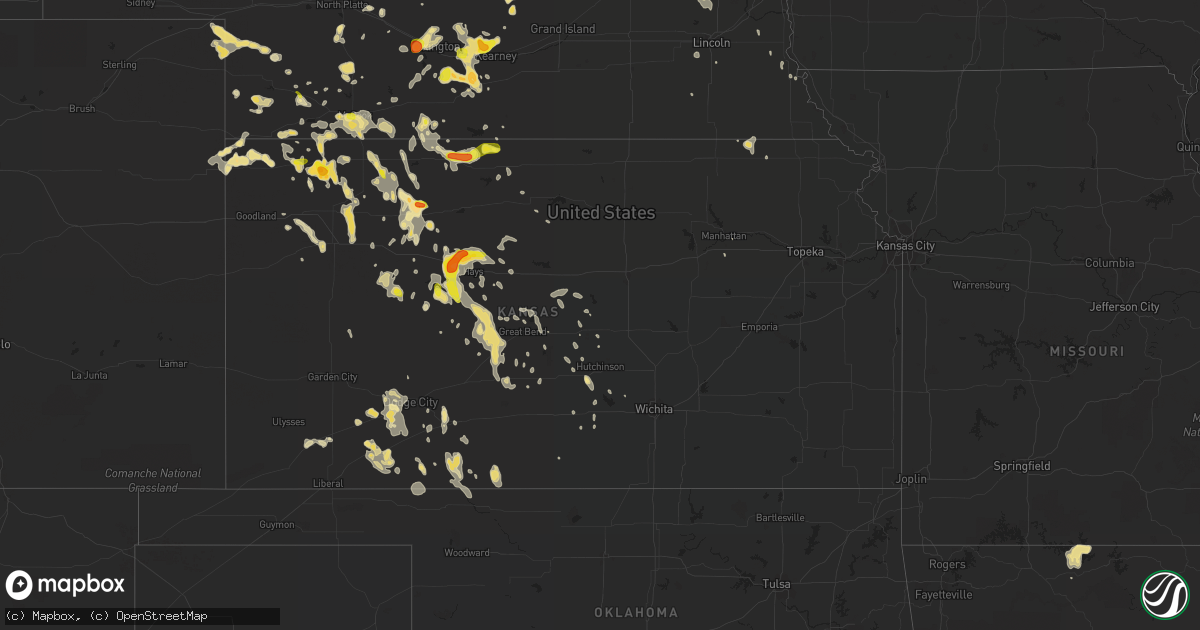
Hail Map in Kansas on June 17, 2016
Get this storm
June 17 map
$229
one time, instant access
Download today. No call, no setup
Keep the $229
Bought the map and want the full workflow? Apply the entire $229 to a subscription within 7 days. None of it is wasted.
Every map, not just this one
This buys you this map. Subscription and you get every map we run, in the markets you choose from a few cities to whole states to nationwide. Plus real-time alerts the moment a storm fires.
Contact data
Name, contact info, occupancy, even credit band for addresses in the footprint. You go from where it hit to who to call.
Become the source they trust
Unlimited branding weather history reports on demand. You already have the documented answer ready for the property owner, and you are the one who showed up with it.
Property data and RoofTrace estimates
Pull up any address you have got, its value and the exact code rules for that jurisdiction, straight from One Click Code. Then RoofTrace estimates the squares, pitch, and roof value, priced the way you price.
Storm reports in Kansas
Kansas
| Date | Description |
|---|---|
| 06/17/20166:30 PM CDT | . |
| 06/17/20166:18 PM CDT | Trained spotter reported hail up to the size of quarters. |
| 06/17/20165:56 PM CDT | . |
| 06/17/20165:50 PM CDT | Also received 1.11 inches of rain and had small hail. |
| 06/17/20165:44 PM CDT | . |
| 06/17/20165:30 PM CDT | . |
| 06/17/20165:30 PM CDT | Falling for about 15 min when report received. |
| 06/17/20165:20 PM CDT | A local report indicates 1.00 inch wind near JENNINGS |
| 06/17/20165:17 PM CDT | . |
| 06/17/20164:34 PM CDT | . |
| 06/17/20164:24 PM CDT | A lot of hail currently falling. |
| 06/17/20164:13 PM CDT | A local report indicates 1.75 inch wind near 8 SSE ATWOOD |
| 06/17/20161:46 AM CDT | Power lines downed in the clearwater area. Report received via social media by kfdi. |
| 06/17/20161:39 AM CDT | Estimated near 135th and central. |
| 06/17/20161:28 AM CDT | Near 21st and 119th. Estimated by an off-duty nws employee. |
| 06/17/20161:26 AM CDT | Measured near the intersection of central and zoo. |
| 06/17/20161:25 AM CDT | Delayed report. |
| 06/17/20161:15 AM CDT | Delayed report of 60 mph winds and 2 inch tree limbs down. |
| 06/17/20161:15 AM CDT | Delayed report of 2 to 4 inch tree limbs down. |
| 06/17/20161:12 AM CDT | Estimated 55 to 60 mph near 135th and central. |
| 06/17/20161:01 AM CDT | Near 29th and 119th in northwest wichita. Reported by an off-duty nws employee. |
| 06/17/201612:49 AM CDT | Measured by the asos at the airport. |
| 06/17/201612:46 AM CDT | Received via social media. |
| 06/16/201610:59 PM CDT | Mesonet station 10 ene hudson /qnrk1/. |
| 06/16/201610:34 PM CDT | This report was from the larned-pawnee county airport awos. |
| 06/16/20169:50 PM CDT | There were 3 to 6 inch tree branches broken in town. |
| 06/16/20169:01 PM CDT | . |
| 06/16/20168:40 PM CDT | Tree branches of 2 to 4 inches were broken. There were numerous tree branches broken across town. |
| 06/16/20168:36 PM CDT | A local report indicates 62 MPH wind near 15 SE GOVE |
| 06/16/20167:55 PM CDT | . |
All States Impacted by Hail Map on June 17, 2016
Cities Impacted by Hail Map on June 17, 2016
- Wakeeney, KS
- Hill City, KS
- Colton, SD
- Richmond, MN
- Cold Spring, MN
- Eastover, SC
- Gadsden, SC
- Hopkins, SC
- Columbia, SC
- Wray, CO
- Alma, GA
- Lenora, KS
- Burwell, NE
- Perham, MN
- Sidon, MS
- Cruger, MS
- Mena, AR
- Saint Francis, KS
- Shellman, GA
- Cuthbert, GA
- Coleman, GA
- Andrews, SC
- Georgetown, SC
- Elm Creek, NE
- Riverdale, NE
- Kearney, NE
- Amherst, NE
- Cimarron, KS
- Atwood, KS
- Weston, WY
- Broadus, MT
- Spencer, SD
- North Bend, NE
- Menahga, MN
- Nevis, MN
- Camden, SC
- Fulton, MS
- Hawley, MN
- Lake Park, MN
- Fosston, MN
- Cove, AR
- Watson, OK
- Smithville, OK
- Hatfield, AR
- North Platte, NE
- Hamilton, AL
- Winfield, AL
- Eldridge, AL
- Brilliant, AL
- Carbon Hill, AL
- Nauvoo, AL
- Haleyville, AL
- Bear Creek, AL
- Beaver City, NE
- Eastman, GA
- Litchfield, MN
- Paynesville, MN
- Eden Valley, MN
- Grove City, MN
- Aladdin, WY
- Hulett, WY
- Alva, WY
- Nettleton, MS
- Dawson, MN
- Madison, MN
- Ponsford, MN
- Aberdeen, MS
- Prairie, MS
- Fitzgerald, GA
- Gettysburg, SD
- Hoven, SD
- Kingsley, IA
- Pierson, IA
- Heidelberg, MS
- Vossburg, MS
- Pinewood, SC
- Wilmore, KS
- Coldwater, KS
- Saint George, SC
- Phillipsburg, KS
- Stewart, MN
- Buffalo Lake, MN
- Lake Lillian, MN
- Hector, MN
- Penokee, KS
- Morland, KS
- McDonald, KS
- Cross, SC
- Holly Hill, SC
- Prague, NE
- Newnan, GA
- Sharpsburg, GA
- Martin, SC
- Holdrege, NE
- Atlanta, NE
- Heflin, AL
- Carrollton, MS
- Sedgwick, CO
- Haxtun, CO
- Anniston, AL
- Albany, MN
- Saint Martin, MN
- Solway, MN
- Shevlin, MN
- Gonvick, MN
- Lengby, MN
- Trail, MN
- Gully, MN
- Bagley, MN
- Clearbrook, MN
- Oberlin, KS
- Warrenton, GA
- Mitchell, GA
- Eagle Bend, MN
- Bertha, MN
- Lake Village, AR
- Eudora, AR
- Lake, MS
- Forest, MS
- Waterford, MS
- Holly Springs, MS
- Heavener, OK
- Rutland, SD
- Madison, SD
- Nunda, SD
- Winfred, SD
- Montrose, SD
- Wentworth, SD
- Copeland, KS
- Grygla, MN
- Goodridge, MN
- Plummer, MN
- Broxton, GA
- Murdock, NE
- Weeping Water, NE
- Battle Lake, MN
- Big Falls, MN
- Hurley, SD
- Parker, SD
- Shaw, MS
- Indianola, MS
- Leland, MS
- Yatesville, GA
- Thomaston, GA
- Lorraine, KS
- Holyrood, KS
- Snow Lake, AR
- Ellinwood, KS
- Claflin, KS
- Sparta, GA
- Benkelman, NE
- Max, NE
- Stratton, NE
- Register, GA
- Statesboro, GA
- Metter, GA
- Osakis, MN
- Carlos, MN
- Miltona, MN
- Long Prairie, MN
- Saint Onge, SD
- Spearfish, SD
- Scribner, NE
- Fremont, NE
- Hooper, NE
- Ames, NE
- Irmo, SC
- Tuscaloosa, AL
- Chauncey, GA
- Danville, AL
- Dunning, NE
- Savannah, GA
- Draper, SD
- Union, SC
- Blair, SC
- Carlisle, SC
- Union, MS
- Oakland, AR
- Yellville, AR
- Peel, AR
- Amory, MS
- Osage, MN
- Park Rapids, MN
- Julesburg, CO
- Goose Creek, SC
- Charleston, SC
- Huger, SC
- Liberty, MS
- Ravenna, NE
- Olivia, MN
- Danube, MN
- Greeley, NE
- Rockville, NE
- Loup City, NE
- Ashton, NE
- Centre, AL
- Piedmont, AL
- Crookston, MN
- Greenbush, MN
- Strathcona, MN
- Junction City, KS
- Bruce, MS
- Banner, MS
- Ailey, GA
- Mount Vernon, GA
- Vidalia, GA
- Browerville, MN
- Cushing, MN
- Cascilla, MS
- Morrow, GA
- Conley, GA
- Ellenwood, GA
- Rex, GA
- Atlanta, GA
- Jonesboro, GA
- Stockbridge, GA
- Forest Park, GA
- Pickens, AR
- Dumas, AR
- Buchanan, GA
- Rome, GA
- Silver Creek, GA
- Cave Spring, GA
- Cedartown, GA
- Rockmart, GA
- Aragon, GA
- Lindale, GA
- Kennesaw, GA
- Marietta, GA
- Brewster, KS
- Russellville, AL
- Tuscumbia, AL
- Lexington, NE
- Cozad, NE
- Panacea, FL
- Phil Campbell, AL
- Milan, GA
- Hoxie, KS
- Selden, KS
- Colby, KS
- Grinnell, KS
- Rexford, KS
- Rienzi, MS
- Corinth, MS
- Haven, KS
- Litchfield, NE
- Boelus, NE
- Minneola, KS
- Kelliher, MN
- Houlka, MS
- Red Bay, AL
- Reevesville, SC
- Smoaks, SC
- Cottageville, SC
- Walterboro, SC
- Round O, SC
- Ruffin, SC
- Dorchester, SC
- Ridgeville, SC
- Loomis, NE
- Madison, GA
- Newborn, GA
- Detroit Lakes, MN
- Callaway, MN
- Holcomb, MS
- Greenwood, MS
- Elyria, NE
- Ord, NE
- Sebeka, MN
- Vining, MN
- Sauk Centre, MN
- Nelson, MN
- Henning, MN
- Clarissa, MN
- New York Mills, MN
- Clitherall, MN
- Bluffton, MN
- Verndale, MN
- Hewitt, MN
- Deer Creek, MN
- West Union, MN
- Villard, MN
- Parkers Prairie, MN
- Wadena, MN
- Brownell, KS
- Ellis, KS
- Brady, NE
- Aurora, SD
- Brookings, SD
- Volga, SD
- Gove, KS
- Quinter, KS
- Alzada, MT
- Tillar, AR
- Columbus, MS
- Hamilton, MS
- Caledonia, MS
- Stapleton, NE
- Meridian, MS
- Bailey, MS
- Dodge City, KS
- Byron, GA
- Fort Valley, GA
- Hutchinson, MN
- Salley, SC
- Springfield, SC
- Wagener, SC
- Aiken, SC
- Kingstree, SC
- Witten, SD
- Mutual, OK
- Mooreland, OK
- Round Lake, MN
- Bemidji, MN
- Pomaria, SC
- May, OK
- McCracken, KS
- Hays, KS
- Newton, MS
- Idalia, CO
- Sumter, SC
- Alcolu, SC
- Manning, SC
- Pretty Prairie, KS
- Rush Center, KS
- Larned, KS
- Bonifay, FL
- Smiths Station, AL
- Gordon, AL
- Marianna, FL
- Cottonwood, AL
- Lebanon, SD
- Tolstoy, SD
- Carrollton, GA
- Jacksonville, AL
- Franklin, GA
- Woodland, AL
- Fruithurst, AL
- Tallapoosa, GA
- Bowdon, GA
- Roopville, GA
- Bremen, GA
- Waco, GA
- Gadsden, AL
- Graham, AL
- Warner Robins, GA
- Maywood, NE
- Altha, FL
- Brooks, MN
- Clinton, SC
- Bowman, SC
- St John, KS
- Itta Bena, MS
- Wauneta, NE
- Ruleville, MS
- Merigold, MS
- Mound Bayou, MS
- Drew, MS
- Danbury, NE
- Culbertson, NE
- McCook, NE
- Indianola, NE
- Inman, KS
- Sturgis, SD
- Rothsay, MN
- Presho, SD
- Vivian, SD
- Nashua, MN
- Campbell, MN
- Ogallah, KS
- Uriah, AL
- Little River, AL
- Bucklin, KS
- Hawkinsville, GA
- Smithville, MS
- Hosford, FL
- Bogue, KS
- Edison, NE
- Norton, KS
- Hendley, NE
- Arapahoe, NE
- Maynard, MN
- Murdock, MN
- Montevideo, MN
- Benson, MN
- Ponca, NE
- Waterbury, NE
- Emerson, NE
- Allen, NE
- Collins, MS
- Shorterville, AL
- Abbeville, AL
- Atmore, AL
- Belle Fourche, SD
- Beulah, WY
- Whitewood, SD
- Sundance, WY
- Louisville, GA
- Water Valley, MS
- Moncks Corner, SC
- Summerville, SC
- Wanda, MN
- Lamberton, MN
- Sanborn, MN
- Redwood Falls, MN
- Wabasso, MN
- Maxwell, NE
- Belview, MN
- Duncanville, AL
- Ranburne, AL
- Inwood, IA
- Larchwood, IA
- Kulm, ND
- Ashley, ND
- Edgeley, ND
- Smithfield, NE
- Bertrand, NE
- Funk, NE
- Norcatur, KS
- Waynoka, OK
- Greenville, MS
- Lower Brule, SD
- Moorcroft, WY
- Devils Tower, WY
- Gillette, WY
- Rozet, WY
- Edson, KS
- Lexington, MS
- Vaiden, MS
- Coila, MS
- Belzoni, MS
- Moorhead, MS
- Winona, MS
- Tchula, MS
- West, MS
- White, SD
- Ivanhoe, MN
- Canby, MN
- Hendricks, MN
- Granite Falls, MN
- Town Creek, AL
- Moulton, AL
- Olar, SC
- Denmark, SC
- Plains, KS
- Fowler, KS
- Meade, KS
- Thomasville, AL
- Coffeeville, AL
- Silas, AL
- Jackson, AL
- Springfield, SD
- Avon, SD
- Cass Lake, MN
- Ewing, NE
- Soperton, GA
- Hardeeville, SC
- Orrville, AL
- Atwater, MN
- Selfridge, ND
- Niobrara, NE
- Tyndall, SD
- Bellvue, CO
- Port Wentworth, GA
- Loveland, CO
- Cambridge, NE
- Bartley, NE
- Saint Stephen, SC
- Pineville, SC
- Buffalo, WY
- Kaycee, WY
- Ashland, KS
- Protection, KS
- Hot Springs National Park, AR
- Malvern, AR
- Erhard, MN
- Fergus Falls, MN
- Boyle, MS
- Cleveland, MS
- Philadelphia, MS
- Carthage, MS
- Astoria, SD
- Kingman, KS
- Murdock, KS
- Great Bend, KS
- Tea, SD
- Chancellor, SD
- Lennox, SD
- Ensign, KS
- Champion, NE
- Melrose, MN
- Victoria, KS
- Potts Camp, MS
- Addison, AL
- Vinemont, AL
- Parks, NE
- Moscow, KS
- Crawfordville, FL
- Spruce Pine, AL
- Porter, MN
- Lesterville, SD
- Bison, KS
- La Crosse, KS
- Ideal, SD
- Winner, SD
- Rock Valley, IA
- Sioux Center, IA
- Hawarden, IA
- Ireton, IA
- Venango, NE
- Amherst, CO
- Grant, NE
- Madrid, NE
- Chapin, SC
- Lowndesboro, AL
- Starkville, MS
- Menno, SD
- Olivet, SD
- Frazee, MN
- Prairie View, KS
- Mcdonough, GA
- Jackson, GA
- Covington, GA
- Sterrett, AL
- Carriere, MS
- Elwood, NE
- Comstock, NE
- Ericson, NE
- Scotia, NE
- Taylor, NE
- Helena, AL
- Montevallo, AL
- Alabaster, AL
- Bessemer, AL
- Jessie, ND
- Cooperstown, ND
- Odenville, AL
- Oneonta, AL
- Springville, AL
- Hartford, AL
- Sylacauga, AL
- Goodwater, AL
- Weogufka, AL
- Burbank, SD
- Wedgefield, SC
- Midville, GA
- Millen, GA
- Hudson, SD
- Rockford, AL
- Stratton, CO
- Lebanon, NE
- Wilsonville, NE
- Herndon, KS
- Ludell, KS
- Trenton, NE
- Casper, WY
- Dunbar, NE
- Otoe, NE
- Wellfleet, NE
- Flandreau, SD
- Levant, KS
- Monument, KS
- Brewster, NE
- Twin Valley, MN
- Brandon, MS
- Alpharetta, GA
- Eagle Butte, SD
- Schuyler, NE
- Freeport, MN
- Red Oak, OK
- Oakley, KS
- Clarksville, FL
- Youngstown, FL
- Summerton, SC
- Stewart, MS
- French Camp, MS
- Kilmichael, MS
- Vienna, GA
- Vina, AL
- Ransom, KS
- Staples, MN
- Aldrich, MN
- Dalzell, SC
- Mayesville, SC
- Greenwood Springs, MS
- Canistota, SD
- Humboldt, SD
- Crary, ND
- Lakota, ND
- Richville, MN
- Belgrade, MN
- Dent, MN
- Echo, MN
- Lucan, MN
- Vesta, MN
- Schlater, MS
- Sunflower, MS
- Doddsville, MS
- Otter, MT
- Underwood, MN
- Palisade, NE
- Hayes Center, NE
- Taylorsville, GA
- Cartersville, GA
- Clements, MN
- Morton, MN
- Sleepy Eye, MN
- Morgan, MN
- Leighton, AL
- Mount Hope, AL
- Adger, AL
- Brookwood, AL
- Scott City, KS
- Ford, KS
- Newcastle, NE
- Gorham, KS
- Russell, KS
- Bay Minette, AL
- West Blocton, AL
- McCalla, AL
- Hull, IA
- Doon, IA
- Arco, MN
- Taunton, MN
- Minneota, MN
- Bassett, NE
- Gregory, SD
- Herrick, SD
- Springview, NE
- Dallas, SD
- Mills, NE
- Burke, SD
- Bird Island, MN
- Blomkest, MN
- Mizpah, MN
- Dublin, GA
- Dexter, GA
- Rentz, GA
- Watkins, MN
- New London, MN
- Spicer, MN
- Darwin, MN
- Jennings, KS
- Dresden, KS
- Clayton, KS
- Braithwaite, LA
- Cullman, AL
- Holbrook, NE
- Eustis, NE
- Springfield, MN
- Lodge, SC
- Islandton, SC
- Hayden, AL
- Montpelier, ND
- Opelika, AL
- Salem, AL
- Chester, OK
- Raymond, MN
- Kerkhoven, MN
- Dighton, KS
- Utica, KS
- Harleyville, SC
- Shuqualak, MS
- Tupelo, MS
- Verona, MS
- Jacksboro, TX
- Sharon, ND
- Woodstock, AL
- Waubun, MN
- Berry, AL
- Satanta, KS
- Broken Bow, NE
- Sargent, NE
- Ottertail, MN
- Hoisington, KS
- Mullinville, KS
- Uniontown, AL
- Pelahatchie, MS
- Alexandria, MN
- Glenwood, MN
- Park, KS
- Rebecca, GA
- Ellendale, ND
- Elgin, SC
- Lugoff, SC
- Stafford, KS
- New Ulm, MN
- Taloga, OK
- Vici, OK
- Seiling, OK
- Eupora, MS
- Gore Springs, MS
- Grenada, MS
- Duck Hill, MS
- Lincolnton, GA
- Crystal Springs, MS
- Florence, MS
- Otis, KS
- Pawnee Rock, KS
- Belpre, KS
- Lincoln, AL
- Roberta, GA
- Greeleyville, SC
- Salters, SC
- New Zion, SC
- Booneville, MS
- Windom, MN
- Lake City, SC
- Blue Mountain, MS
- Bethel, OK
- Broken Bow, OK
- Culloden, GA
- Imperial, NE
- Cochran, GA
- Graniteville, SC
- North Augusta, SC
- Overton, NE
- Tenstrike, MN
- Isle Of Palms, SC
- Awendaw, SC
- Mount Pleasant, SC
- Vergas, MN
- Pelican Rapids, MN
- Emery, SD
- Alexandria, SD
- Bridgewater, SD
- Marietta, MS
- New Site, MS
- Ridgeland, SC
- Yemassee, SC
- Selma, AL
- Marion Junction, AL
- Big Creek, MS
- Dothan, AL
- Tunica, MS
- Quincy, FL
- Tallahassee, FL
- Tremont, MS
- Kingston, GA
- Weston, NE
- Star City, AR
- Sumner, NE
- Miller, NE
- Odessa, NE
- Wilcox, NE
- Graceville, FL
- Waynesboro, MS
- Buckatunna, MS
- Atkinson, NE
- Pontotoc, MS
- Blountsville, AL
- Blythewood, SC
- Ridgeway, SC
- Portis, KS
- Ponemah, MN
- Utica, SD
- Banner, WY
- Story, WY
- Marion, AL
- Bay Springs, MS
- Paulding, MS
- Louin, MS
- Branchville, SC
- Barnwell, SC
- Griffin, GA
- Kandiyohi, MN
- Freedom, OK
- Fort Pierre, SD
- Slocomb, AL
- Baudette, MN
- Clearwater, NE
- Elgin, NE
- Oakdale, NE
- Chambers, NE
- Garretson, SD
- Jasper, MN
- Trent, SD
- Bruce, SD
- Leonard, MN
- Reynolds, GA
- Butler, GA
- Daviston, AL
- Northwood, ND
- Clewiston, FL
- Sharon, OK
- Waynesboro, GA
- Rochert, MN
- Audubon, MN
- Hiram, GA
- Dallas, GA
- Rockledge, GA
- East Dublin, GA
- Lyons, GA
- Tarrytown, GA
- Moville, IA
- Maurice, IA
- Remsen, IA
- Correctionville, IA
- Merrill, IA
- Le Mars, IA
- Hinton, IA
- Bird City, KS
- Milledgeville, GA
- Erskine, MN
- Mcintosh, MN
- Winger, MN
- Wagner, SD
- Oakman, AL
- Northport, AL
- Ness City, KS
- Villa Rica, GA
- Temple, GA
- Eatonton, GA
- Tallassee, AL
- Eclectic, AL
- Hope Hull, AL
- Stuart, NE
- Monticello, AR
- Bethune, CO
- Ohatchee, AL
- Canton, MS
- Sardis, AL
- McGehee, AR
- Lucedale, MS
- Lyons, KS
- Jeffers, MN
- Elko, GA
- Campbellton, FL
- Bancroft, NE
- McIntyre, GA
- Boyd, MN
- Colman, SD
- Elkton, SD
- Tuskegee, AL
- Union Springs, AL
- Hardaway, AL
- Shorter, AL
- Thief River Falls, MN
- Pillager, MN
- Ashland, AL
- Alexander City, AL
- Lexington, SC
- Gibbon, MN
- Saint Matthews, SC
- Kensington, KS
- Lagrange, GA
- Roanoke, AL
- Five Points, AL
- Sacred Heart, MN
- Naper, NE
- Aline, OK
- New Underwood, SD
- Roosevelt, MN
- Williams, MN
- Olive Branch, MS
- Hernando, MS
- Geddes, SD
- Fountain, FL
- New Albany, MS
- Brinson, GA
- Bainbridge, GA
- Elk Point, SD
- Wewahitchka, FL
- Axtell, NE
- Warthen, GA
- Columbiana, AL
- Calera, AL
- Jemison, AL
- Shelby, AL
- Plainville, KS
- Catharine, KS
- York, AL
- Mount Vernon, SD
- Corsica, SD
- Adairsville, GA
- Spencer, NE
- Oneill, NE
- Newbern, AL
- Ada, MN
- Haigler, NE
- Dacula, GA
- Lawrenceville, GA
- Motley, MN
- Hickory Flat, MS
- Dermott, AR
- Decatur, MS
- Cadwell, GA
- McRae Helena, GA
- New Orleans, LA
- Steens, MS
- Ulen, MN
- Mulhall, OK
- Crescent, OK
- Bluffton, SC
- Minter, AL
- Lake Andes, SD
- Olmitz, KS
- West Point, MS
- Okolona, MS
- Houston, MS
- Cope, SC
- Norway, SC
- Hillman, MN
- Milaca, MN
- Fairfax, SD
- Arley, AL
- Hazlehurst, GA
- West Green, GA
- Nicholls, GA
- Axtell, KS
- Summerfield, KS
- Redlake, MN
- Avon Park, FL
- Shubuta, MS
- Altoona, AL
- Cleveland, AL
- Albert, KS
- Salol, MN
- Ashville, AL
- Warroad, MN
- Iron City, GA
- Pequot Lakes, MN
- Pine River, MN
- Ogema, MN
- Jud, ND
- Reform, AL
- Chester, SD
- Watson, MN
- Milan, MN
- Yutan, NE
- Beattie, KS
- Clarkson, NE
- Dodge, NE
- Rogers, NE
- Howells, NE
- Linwood, NE
- Almena, KS
- Benoit, MS
- Belle Chasse, LA
- Natoma, KS
- Paradise, KS
- Hartford, SD
- Palco, KS
- Cottondale, FL
- Marion, ND
- Peru, NE
- Nebraska City, NE
- Alcester, SD
- Dell Rapids, SD
- Gable, SC
- Delta, AL
- Lineville, AL
- Parrish, AL
- Washington, GA
- Daleville, MS
- Salem, SD
- Glenwood, GA
- Clanton, AL
- Brierfield, AL
- Leigh, NE
- Partridge, KS
- Cordova, SC
- Bowdle, SD
- Como, MS
- Mahnomen, MN
- Clarks Hill, SC
- Powder Springs, GA
- Canova, SD
- Hephzibah, GA
- Fairfax, MN
- Cameron, SC
- Fosters, AL
- Ralph, AL
- Coker, AL
- Buhl, AL
- Flippin, AR
- Moody, AL
- Chalmette, LA
- Arabi, LA
- Lena, MS
- Morton, MS
- Long Island, KS
- Abbeville, GA
- Cedar Bluffs, NE
- Camden, AL
- Waskish, MN
- Michigan, ND
- Newfolden, MN
- Hitterdal, MN
- Grey Eagle, MN
- Roscoe, MN
- Barnesville, MN
- Brooks, GA
- Williamson, GA
- Zebulon, GA
- Senoia, GA
- Oxford, AL
- Munford, AL
- Courtland, MN
- Rembert, SC
- Danvers, MN
- Custer City, OK
- Lake Benton, MN
- Clayton, AL
- Fargo, OK
- Woodward, OK
- Sinai, SD
- Arlington, SD
- Clarkfield, MN
- Toronto, SD
- Abbyville, KS
- Sterling, KS
- Whitmire, SC
- Newberry, SC
- Rochelle, GA
- Mullen, NE
- Tryon, NE
- Woodland, MS
- Vardaman, MS
- Crosslake, MN
- Fifty Lakes, MN
- Malmo, NE
- Rydal, GA
- White, GA
- Douglasville, GA
- Hogansville, GA
- Tyler, AL
- Oakland, MS
- Tillatoba, MS
- Cordele, GA
- Pitts, GA
- Nisland, SD
- Millport, AL
- Dudley, GA
- Abbeville, MS
- Byhalia, MS
- Oxford, MS
- Tabor, SD
- Ashburn, GA
- Autaugaville, AL
- Bishopville, SC
- Roseau, MN
- Ellsworth, KS
- Rhine, GA
- Jacksonville, GA
- Wray, GA
- Bloomington, NE
- Greensboro, GA
- Rohwer, AR
- Shelby, MS
- Inverness, MS
- Gunnison, MS
- Minter City, MS
- McCarley, MS
- Charleston, MS
- Durant, MS
- Parchman, MS
- Watson, AR
- Hollandale, MS
- North Carrollton, MS
- Tutwiler, MS
- Beulah, MS
- Ethel, MS
- Pickens, MS
- Orangeburg, SC
- Rosston, OK
- Englewood, KS
- Canton, GA
- Woodstock, GA
- Little River, KS
- Duluth, GA
- Calhoun City, MS
- Chester, GA
- Freeman, SD
- Sublette, KS
- Monticello, GA
- Shady Dale, GA
- De Witt, NE
- Estill, SC
- Quitman, MS
- Townley, AL
- Seneca, KS
- Toxey, AL
- Needham, AL
- Hanley Falls, MN
- Gilbertown, AL
- Notasulga, AL
- Blue Springs, MS
- Laporte, MN
- Buffalo, OK
- Chunky, MS
- Little Rock, MS
- Ehrhardt, SC
- Columbus, NE
- Vale, SD
- Pineview, GA
- Glenrock, WY
- Alvord, IA
- Rock Rapids, IA
- Decatur, GA
- Lithonia, GA
- Rainbow City, AL
- Ethelsville, AL
- Curtis, NE
- Eddyville, NE
- Carrollton, AL
- Scobey, MS
- Coffeeville, MS
- Alva, OK
- Kennebec, SD
- Puposky, MN
- Thomson, GA
- Baxley, GA
- Hartington, NE
- Fordyce, NE
- Okatie, SC
- Oxford, NE
- Blackduck, MN
- Myrtle, MS
- Crane Hill, AL
- Dalton, MN
- Nickerson, KS
- Brewton, AL
- Evergreen, AL
- Dupree, SD
- Lantry, SD
- Mooreville, MS
- Halsey, NE
- Oklee, MN
- Gordo, AL
- Elrod, AL
- Double Springs, AL
- Cades, SC
- Gallant, AL
- Cosmos, MN
- Northome, MN
- Brandon, MN
- Evansville, MN
- Dassel, MN
- Willmar, MN
- Brooten, MN
- Swanville, MN
- Agra, KS
- Attalla, AL
- Jenkinsburg, GA
- Locust Grove, GA
- Anselmo, NE
- Montezuma, KS
- Geneseo, KS
- Osborne, KS
- Orange City, IA
- Hospers, IA
- Detroit, AL
- Golden, MS
- Mantachie, MS
- Grady, AR
- Denton, NE
- Yuma, CO
- Waterloo, NE
- Beltrami, MN
- Greensboro, AL
- Macksville, KS
- Gaylord, KS
- Unadilla, GA
- Andale, KS
- Mount Hope, KS
- Peachtree City, GA
- Burtrum, MN
- Jetmore, KS
- Nickerson, NE
- Plantersville, MS
- Fayette, AL
- Girard, GA
- Sylvania, GA
- Tichnor, AR
- Lane, SC
- Quinton, AL
- Seminary, MS
- Ellisville, MS
- Wedowee, AL
- Kirwin, KS
- Bristol, FL
- Hickman, NE
- Roca, NE
- Pittsboro, MS
- Early Branch, SC
- Coosawhatchie, SC
- Varnville, SC
- Claxton, GA
- Eutaw, AL
- Emmet, NE
- Amelia, NE
- Sumner, MS
- Waverly, AL
- Horton, AL
- Holly Pond, AL
- Trussville, AL
- Remlap, AL
- Alexander, KS
- Ripley, MS
- Cedar Bluff, AL
- Chattahoochee, FL
- Hudson, KS
- Terry, MS
- Winona, KS
- Dumas, MS
- Baldwyn, MS
- Guntown, MS
- Alford, FL
- Callaway, NE
- Auburn, AL
- Byromville, GA
- Pinehurst, GA
- Moore Haven, FL
- Wilmar, AR
- Belden, MS
- Laverne, OK
- Fort Gaines, GA
- Pender, NE
- Thurston, NE
- Neeses, SC
- Colon, NE
- Eutawville, SC
- Labelle, FL
- Adrian, GA
- Montezuma, GA
- Grayson, GA
- Loganville, GA
- Valley, NE
- Batesburg, SC
- Pennock, MN
- Alamo, GA
- Midland, GA
- Athol, KS
- Miami, FL
- Platte, SD
- Ethan, SD
- Fort Supply, OK
- Arnett, OK
- Oden, AR
- Mount Ida, AR
- Randolph, MS
- Leedey, OK
- Sharon, KS
- Etta, MS
- Thaxton, MS
- Seaforth, MN
- Bonesteel, SD
- Scotland, SD
- Elsie, NE
- Columbus, GA
- Appling, GA
- Modoc, SC
- Mitchell, SD
- Hackleburg, AL
- Soso, MS
- Taylorsville, MS
- Nesbit, MS
- Crawfordville, GA
- Pawnee City, NE
- Burchard, NE
- Parkston, SD
- Enterprise, MS
- Pine Apple, AL
- Wetumpka, AL
- Chipley, FL
- Kathleen, GA
- Perry, GA
- Vance, MS
- Lambert, MS
- Saltillo, MS
- Manhattan, KS
- Gothenburg, NE
- Bankston, AL
- Saint Marks, FL
- Cottondale, AL
- Newton, AL
- Moundville, AL
- Holyoke, CO
- Hutchinson, KS
- Gould, AR
- Letohatchee, AL
- Anthon, IA
- Valparaiso, NE
- Ceresco, NE
- Morse Bluff, NE
- Bamberg, SC
- Steen, MN
- McDavid, FL
- Philipp, MS
- Bejou, MN
- Centreville, AL
- Tyrone, GA
- Red Banks, MS
- Akeley, MN
- Telogia, FL
- Cassatt, SC
- Lynchburg, SC
- Arabi, GA
- Oconto, NE
- Franklin, MN
- Hanska, MN
- Hickory, MS
- Benton, AR
- Satsuma, AL
- Saraland, AL
- Belmont, MS
- Cherokee, AL
- Dennis, MS
- Tishomingo, MS
- Iuka, MS
- Hodges, AL
- Black, AL
- West Point, NE
- Arnold, NE
- Augusta, GA
- Appleton, MN
- Tipton, KS
- Tallulah, LA
- Collyer, KS
- Fertile, MN
- Pleasanton, NE
- Camp Hill, AL
- Vance, SC
- Santee, SC
- Bonaire, GA
- Dry Branch, GA
- Safford, AL
- Thomaston, AL
- Jenkinsville, SC
- Winnsboro, SC
- Arlington, NE
- Rozel, KS
- Beaufort, SC
- Logan, KS
- Boyes, MT
- Winthrop, MN
- Trenton, TN
- Blountstown, FL
- Swainsboro, GA
- Clara City, MN
- Lafayette, AL
- Harlem, GA
- Grovetown, GA
- Wahoo, NE
- Lake George, MN
- Norwood, GA
- Gackle, ND
- Falkville, AL
- Howard, SD
- Sulligent, AL
- Wilson, KS
- Brownton, MN
- Montrose, AR
- Fayetteville, GA
- Concord, GA
- Dyersburg, TN
- Grainfield, KS
- Hubbard, NE
- Wakefield, NE
- Jackson, NE
- Republican City, NE
- Naponee, NE
- Pooler, GA
- Hanahan, SC
- Panama City, FL
- Neche, ND
- Marietta, MN
- Drake, CO


