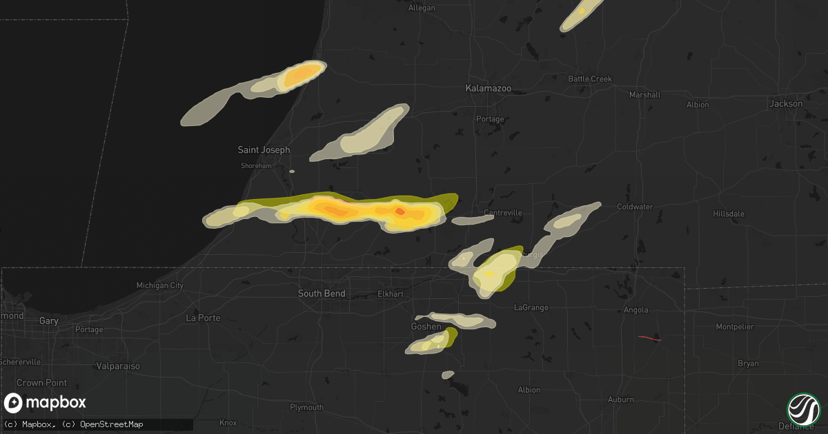
Hail Map in Vandalia, MI on June 16, 2026
Get this storm
June 16 map
$229
one time, instant access
Download today. No call, no setup
Keep the $229
Bought the map and want the full workflow? Apply the entire $229 to a subscription within 7 days. None of it is wasted.
Every map, not just this one
This buys you this map. Subscription and you get every map we run, in the markets you choose from a few cities to whole states to nationwide. Plus real-time alerts the moment a storm fires.
Contact data
Name, contact info, occupancy, even credit band for addresses in the footprint. You go from where it hit to who to call.
Become the source they trust
Unlimited branding weather history reports on demand. You already have the documented answer ready for the property owner, and you are the one who showed up with it.
Property data and RoofTrace estimates
Pull up any address you have got, its value and the exact code rules for that jurisdiction, straight from One Click Code. Then RoofTrace estimates the squares, pitch, and roof value, priced the way you price.
Storm reports in Vandalia, MI
Vandalia, MI
| Date | Description |
|---|---|
| 06/16/20266:12 PM CDT | 2.17 inch measured hail stone measured with photo. Also observed ping pong to golf ball sized hail. |
| 06/16/20266:09 PM CDT | Report from mping: half dollar |
| 06/16/20266:05 PM CDT | A local report indicates 1.75 inch wind near Vandalia |
All States Impacted by Hail Map on June 16, 2026
All Cities Impacted by Hail Map on June 16, 2026
- Green Valley, IL
- Pekin, IL
- Tremont, IL
- Curran, MI
- Hubbard Lake, MI
- Lachine, MI
- Wisconsin Rapids, WI
- Milford, MI
- Roscommon, MI
- Saint Helen, MI
- Bear Creek, WI
- Pardeeville, WI
- West Branch, MI
- Luzerne, MI
- Clintonville, WI
- Rose City, MI
- Dalton, WI
- Shiocton, WI
- Gladwin, MI
- Weyauwega, WI
- Highland, MI
- Markesan, WI
- Fremont, WI
- Montello, WI
- Brighton, MI
- Mio, MI
- Fairview, MI
- Comins, MI
- Lewiston, MI
- Oshkosh, WI
- Pickett, WI
- Casco, WI
- Hillman, MI
- West Bend, WI
- Sheboygan, WI
- Algoma, WI
- Iron Ridge, WI
- Hortonville, WI
- Hale, MI
- Atlanta, MI
- Glennie, MI
- South Branch, MI
- Sheboygan Falls, WI
- Oostburg, WI
- Scottville, MI
- Appleton, WI
- Greenville, WI
- Kewaunee, WI
- Campbellsport, WI
- Kaukauna, WI
- Oneida, WI
- Luxemburg, WI
- Lupton, MI
- Clare, MI
- Plymouth, WI
- Cascade, WI
- Saint Cloud, WI
- De Pere, WI
- Green Bay, WI
- Mikado, MI
- Millersburg, MI
- Hawks, MI
- Onaway, MI
- Rogers City, MI
- Adell, WI
- Kiel, WI
- Valders, WI
- Merrill, MI
- Waldo, WI
- Lincoln, MI
- Harrisville, MI
- Midland, MI
- Freeland, MI
- Hemlock, MI
- Oscoda, MI
- Rockford, MI
- Kawkawlin, MI
- Belmont, MI
- Port Austin, MI
- Dowling, MI
- Delton, MI
- Gowen, MI
- Cedar Springs, MI
- Hastings, MI
- Linwood, MI
- Sand Lake, MI
- Battle Creek, MI
- Westphalia, MI
- Greenville, MI
- Eagle, MI
- Portland, MI
- Lakeview, MI
- Shepherd, MI
- Vestaburg, MI
- Mount Pleasant, MI
- Edmore, MI
- Six Lakes, MI
- Remus, MI
- Blanchard, MI
- Pierson, MI
- Stanton, MI
- Trufant, MI
- Coral, MI
- Nashville, MI
- Bellevue, MI
- Howard City, MI
- Fowler, MI
- Saint Johns, MI
- Saint Joseph, IL
- Urbana, IL
- Ogden, IL
- Fithian, IL
- Vermontville, MI
- Muncie, IL
- Oakwood, IL
- Fairmount, IL
- Oxford, IN
- Boswell, IN
- Armstrong, IL
- Catlin, IL
- Homer, IL
- Westville, IL
- Danville, IL
- Camden, IN
- Delphi, IN
- Sopchoppy, FL
- Tallahassee, FL
- Crawfordville, FL
- Georgetown, IL
- Saginaw, MI
- Bay City, MI
- Templeton, IN
- Pine Village, IN
- Otterbein, IN
- Woodland, MI
- Perrysville, IN
- West Lafayette, IN
- Logansport, IN
- Walton, IN
- Galveston, IN
- Hubbardston, MI
- Muir, MI
- Fenwick, MI
- Sunfield, MI
- Champaign, IL
- Mulliken, MI
- Barryton, MI
- Sears, MI
- Lake, MI
- Charlotte, MI
- Grissom Arb, IN
- Peru, IN
- Onward, IN
- Beaverton, MI
- Mount Morris, MI
- Bismarck, IL
- West Lebanon, IN
- Harrison, MI
- Columbus, ND
- Coleman, MI
- Sawyer, MI
- Farwell, MI
- Clio, MI
- Flint, MI
- Bunker Hill, IN
- Miami, IN
- Lignite, ND
- Bowbells, ND
- Baroda, MI
- Bridgman, MI
- Buchanan, MI
- Amboy, IN
- Converse, IN
- Wabash, IN
- Berrien Springs, MI
- Kenmare, ND
- Stanley, ND
- Powers Lake, ND
- South Haven, MI
- Covert, MI
- Eau Claire, MI
- Benton Harbor, MI
- Ashland, KS
- Berrien Center, MI
- Niles, MI
- Dowagiac, MI
- La Fontaine, IN
- Donnybrook, ND
- Palermo, ND
- Loring, MT
- Marshall, IN
- Waveland, IN
- Decatur, MI
- Hartford, MI
- Bloomingdale, IN
- Franklin, MI
- Southfield, MI
- Paris, MI
- Watervliet, MI
- Bloomfield Hills, MI
- Birmingham, MI
- Cassopolis, MI
- Vandalia, MI
- Paw Paw, MI
- Lawrence, MI
- Saint Mary, MO
- Sainte Genevieve, MO
- Berthold, ND
- Marcellus, MI
- Jones, MI
- Gate, OK
- Perryville, MO
- Tonto Basin, AZ
- Cutler, IL
- Pinckneyville, IL
- Viola, KS
- Clearwater, KS
- Tamaroa, IL
- Du Quoin, IL
- Three Rivers, MI
- Cayuga, IN
- Kingman, IN
- Covington, IN
- Ladoga, IN
- Roachdale, IN
- North Salem, IN
- Rosston, OK
- Chinook, MT
- Plaza, ND
- Jetmore, KS
- Spearville, KS
- Wright, KS
- New Paris, IN
- Goshen, IN
- Millersburg, IN
- Howe, IN
- Shipshewana, IN
- Middlebury, IN
- White Pigeon, MI
- Sturgis, MI
- Danville, IN
- Benton, IL
- Scheller, IL
- Waltonville, IL
- Bonnie, IL
- Sesser, IL
- Syracuse, IN
- Minot, ND
- Peck, KS
- Larned, KS
- Garfield, KS
- Constantine, MI
- Glenburn, ND
- Bristol, IN
- Whittington, IL
- Ina, IL
- Ewing, IL
- Centreville, MI
- Sodus, MI
- Belle Plaine, KS
- Brownsburg, IN
- Indianapolis, IN
- Avon, IN
- Belpre, KS
- Ryder, ND
- Des Lacs, ND
- Bronson, MI
- Burr Oak, MI
- Laverne, OK
- Topeka, IN
- Belle Rive, IL
- Ford, KS
- Harlem, MT
- Sherwood, MI
- Coldwater, MI
- Elmira, MI
- Sheridan, MI
- Sidney, MI
- Shattuck, OK
- Macksville, KS
- Freedom, OK
- New Palestine, IN
- Greenfield, IN
- Lansford, ND
- Minot Afb, ND
- Surrey, ND
- Norwich, ND
- Velva, ND
- Granville, ND
- Voltaire, ND
- Ruso, ND
- Butte, ND
- Drake, ND
- Balfour, ND
- Mcclusky, ND
- Denhoff, ND
- Goodrich, ND
- Anamoose, ND
- Bucklin, KS
- Karlsruhe, ND
- Byers, KS
- Greencastle, IN
- Cloverdale, IN
- Mooreland, OK
- Pleasant Lake, IN
- Hamilton, IN
- Pratt, KS
- Scammon, KS
- Cherokee, KS
- Columbus, KS
- Sells, AZ
- Haviland, KS
- Morristown, IN
- Weir, KS
- Collison, IL
- Potomac, IL
- Alvin, IL
- Tucson, AZ
- Waynoka, OK
- Mullinville, KS
- Minneola, KS
- Sawyer, KS
- Coats, KS
- Sun City, KS
- Medicine Lodge, KS
- Protection, KS
- Lake City, KS
- Olpe, KS
- Madison, KS
- Hartford, KS
- Emporia, KS
- Dupree, SD
- Eagle Butte, SD
- Winfield, KS
- Rock, KS
- Burden, KS
- Gridley, KS
- Virgil, KS
- Yates Center, KS
- Cambridge, KS
- Fort Pierre, SD
- Dexter, KS
- Cedar Vale, KS
- Chanute, KS
- Buffalo, KS
- Benedict, KS
- Altoona, KS
- Thayer, KS
- Epping, ND
- Galesburg, KS
- Ray, ND
- Parsons, KS
- Oswego, KS
- Lake Odessa, MI
- Freeport, MI
- Marcus, IA
- Larrabee, IA
- Cleghorn, IA
- Meriden, IA
- Cherokee, IA
- Aurelia, IA
- Alta, IA
- Peterson, IA
- Linn Grove, IA
- Alton, IA
- Storm Lake, IA
- Rembrandt, IA
- Newell, IA
- Truesdale, IA
- Schaller, IA
- Holstein, IA
- Quimby, IA
- Galva, IA
- Paullina, IA
- Granville, IA
- Early, IA
- Nemaha, IA
- Sac City, IA
- Sutherland, IA
- Pomeroy, IA
- Manson, IA
- Williams, IA
- Lytton, IA
- Rockwell City, IA
- Jolley, IA
- Fonda, IA
- Moorland, IA
- Somers, IA
- Gowrie, IA
- Callender, IA
- Washta, IA
- Farnhamville, IA
- Knierim, IA
- Lohrville, IA
- Fort Dodge, IA
- Dayton, IA
- Paton, IA
- Lehigh, IA
- Burnside, IA
- Harcourt, IA
- Otho, IA
- Barnum, IA
- Stratford, IA
- Pierson, IA
- Correctionville, IA
- Cushing, IA
- Boone, IA
- Stanhope, IA
- Pilot Mound, IA
- Boxholm, IA
- Ames, IA
- Gilbert, IA
- Story City, IA
- Ida Grove, IA
- Duncombe, IA
- Keota, IA
- Albert City, IA
- Palmer, IA
- Marathon, IA
- Laurens, IA
- Pocahontas, IA
- Sioux Rapids, IA
- Lake City, IA
- Churdan, IA
- Auburn, IA
- Varina, IA
- Whitten, IA
- Traer, IA
- Clutier, IA
- Hubbard, IA
- Badger, IA
- Melbourne, IA
- Madrid, IA
- Slater, IA
- Huxley, IA
- Randall, IA
- Cambridge, IA
- Kamrar, IA
- Colo, IA
- New Providence, IA
- Webster City, IA
- Ellsworth, IA
- Jefferson, IA
- Ogden, IA
- Saint Anthony, IA
- Clare, IA
- Albion, IA
- Alden, IA
- Marshalltown, IA
- Dana, IA
- Clemons, IA
- Zearing, IA
- Woodward, IA
- Eldora, IA
- Luther, IA
- Kelley, IA
- Conrad, IA
- Vincent, IA
- Grand Junction, IA
- Garwin, IA
- Maxwell, IA
- Collins, IA
- Beaman, IA
- State Center, IA
- Sheldahl, IA
- Humboldt, IA
- Garden City, IA
- Radcliffe, IA
- Liscomb, IA
- Nevada, IA
- Polk City, IA
- Toledo, IA
- Roland, IA
- Blairsburg, IA
- Iowa Falls, IA
- Woolstock, IA
- Beaver, IA
- Jewell, IA
- McCallsburg, IA
- Gladbrook, IA
- Union, IA
- Gilmore City, IA
- Grundy Center, IA
- Steamboat Rock, IA
- Haverhill, IA
- Rhodes, IA
- Ankeny, IA
- Bondurant, IA
- Alleman, IA
- Elkhart, IA
- Montour, IA
- Baxter, IA
- Mingo, IA
- Washington, IA
- West Chester, IA
- Tama, IA
- Colfax, IA
- Newton, IA
- Chelsea, IA
- Ira, IA
- Le Grand, IA
- Brooklyn, IA
- Belle Plaine, IA
- Hartwick, IA
- Monroe, IA
- Kellogg, IA
- Sully, IA
- Lynnville, IA
- Killduff, IA
- Ferguson, IA
- Gilman, IA
- Laurel, IA
- Grinnell, IA
- Dysart, IA
- Reinbeck, IA
- Lincoln, IA
- Malcom, IA
- Reasnor, IA
- Pella, IA
- Otley, IA
- Searsboro, IA
- Vinton, IA
- Montezuma, IA
- Vining, IA
- Keystone, IA
- New Sharon, IA
- Elberon, IA
- Van Horne, IA
- Garrison, IA
- Luzerne, IA
- Leighton, IA
- Marengo, IA
- Blairstown, IA
- Barnes City, IA
- Deep River, IA
- Guernsey, IA
- Victor, IA
- Oskaloosa, IA
- Williamsburg, IA
- Parnell, IA
- Sigourney, IA
- Harper, IA
- Conroy, IA
- Gibson, IA
- What Cheer, IA
- Watkins, IA
- South English, IA
- Millersburg, IA
- Webster, IA
- Newhall, IA
- Ladora, IA
- North English, IA
- Keswick, IA
- Rose Hill, IA
- Wellman, IA
- South Amana, IA
- Shellsburg, IA
- Solon, IA
- Homestead, IA
- Ely, IA
- Oxford, IA
- Walford, IA
- Middle Amana, IA
- North Liberty, IA
- Lisbon, IA
- Cedar Rapids, IA
- Kalona, IA
- Amana, IA
- Mount Vernon, IA
- Fairfax, IA
- Coralville, IA
- Tiffin, IA
- Iowa City, IA
- Marion, IA
- Palo, IA
- Swisher, IA
- Atkins, IA
- Norway, IA
- Ionia, MI
- Panama City, FL


