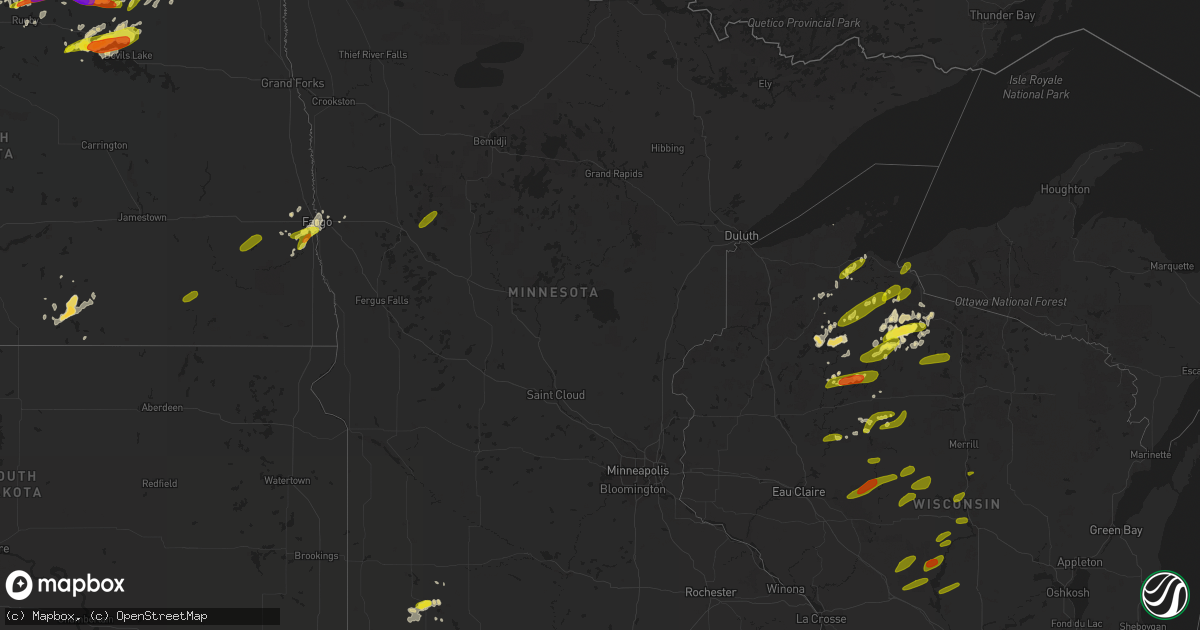
Hail Map in Minnesota on June 14, 2018
Get this storm
June 14 map
$229
one time, instant access
Download today. No call, no setup
Keep the $229
Bought the map and want the full workflow? Apply the entire $229 to a subscription within 7 days. None of it is wasted.
Every map, not just this one
This buys you this map. Subscription and you get every map we run, in the markets you choose from a few cities to whole states to nationwide. Plus real-time alerts the moment a storm fires.
Contact data
Name, contact info, occupancy, even credit band for addresses in the footprint. You go from where it hit to who to call.
Become the source they trust
Unlimited branding weather history reports on demand. You already have the documented answer ready for the property owner, and you are the one who showed up with it.
Property data and RoofTrace estimates
Pull up any address you have got, its value and the exact code rules for that jurisdiction, straight from One Click Code. Then RoofTrace estimates the squares, pitch, and roof value, priced the way you price.
Storm reports in Minnesota
Minnesota
| Date | Description |
|---|---|
| 06/14/20187:44 AM CDT | Dime to half dollar size hail nearly covered the ground. |
| 06/14/20182:42 AM CDT | At 742 AM CDT, a severe thunderstorm was located near Fulda, or 9 miles southeast of Slayton, moving east at 20 mph. HAZARD...Half dollar size hail. SOURCE...Radar indicated. IMPACT...Damage to vehicles is expected. This severe thunderstorm will remain over mainly rural areas of southwestern Cottonwood and southeastern Murray Counties, including the following locations... Avoca. |
| 06/14/20182:14 AM CDT | At 714 AM CDT, a severe thunderstorm was located near Wilmont, or 13 miles south of Slayton, moving east at 35 mph. HAZARD...Quarter size hail. SOURCE...Radar indicated. IMPACT...Damage to vehicles is expected. This severe thunderstorm will be near... Fulda around 730 AM CDT.Other locations impacted by this severe thunderstorm include Kinbraeand Dundee. |
| 06/14/20182:07 AM CDT | A local report indicates 1.00 inch wind near 1 S MOORHEAD |
All States Impacted by Hail Map on June 14, 2018
Cities Impacted by Hail Map on June 14, 2018
- Upham, ND
- Hayward, WI
- Lignite, ND
- Langdon, ND
- Souris, ND
- Heron Lake, MN
- Nekoma, ND
- Fairdale, ND
- Osnabrock, ND
- Mohall, ND
- Douglas, ND
- Norwich, ND
- Minot, ND
- Ryder, ND
- Makoti, ND
- Velva, ND
- Des Lacs, ND
- Berthold, ND
- Sawyer, ND
- Burlington, ND
- Max, ND
- Jefferson City, MO
- Holts Summit, MO
- Bottineau, ND
- Mapleton, ND
- Westbrook, MN
- Falcon, MO
- Lynchburg, MO
- Douds, IA
- Kramer, ND
- Mellen, WI
- Parshall, ND
- Sherwood, ND
- Saint John, ND
- Wales, ND
- Perth, ND
- Hampden, ND
- Rocklake, ND
- Mylo, ND
- Starkweather, ND
- Munich, ND
- Alsen, ND
- Bisbee, ND
- Rolla, ND
- Egeland, ND
- Cando, ND
- Agate, ND
- Rolette, ND
- Rugby, ND
- Reeder, ND
- Napoleon, ND
- Alamo, ND
- Albia, IA
- Willow City, ND
- Westhope, ND
- Newburg, ND
- Hettinger, ND
- Bussey, IA
- Dunseith, ND
- Ashland, WI
- Butternut, WI
- Mendota, IL
- Compton, IL
- Columbus, ND
- Noonan, ND
- Crosby, ND
- Portal, ND
- Flaxton, ND
- Bowbells, ND
- Tioga, ND
- Camp, AR
- Mammoth Spring, AR
- Newburg, MO
- Dixon, MO
- Bowling Green, MO
- Middletown, MO
- Mercer, WI
- Rolla, MO
- Zeeland, ND
- Houston, MO
- Licking, MO
- Raymondville, MO
- Glidden, WI
- Maxbass, ND
- Palermo, ND
- Stanley, ND
- Edgar, WI
- Lovilia, IA
- Ogema, WI
- Wisconsin Rapids, WI
- Keosauqua, IA
- Horace, ND
- Perry, MO
- Santa Fe, MO
- Eddyville, IA
- Mount Sterling, IA
- Lansford, ND
- Rogersville, MO
- Fordland, MO
- Elsberry, MO
- Silex, MO
- West Plains, MO
- Donnybrook, ND
- Winter, WI
- Springfield, MO
- Park Falls, WI
- Tracy, IA
- Knoxville, IA
- Harvey, IA
- Garrison, ND
- Surrey, ND
- Horseshoe Bend, AR
- Franklin, AR
- Dagmar, MT
- Gilman, WI
- Beulah, ND
- Halliday, ND
- Peace Valley, MO
- Nashua, MT
- Phillips, WI
- Golden Valley, ND
- Dodge, ND
- Wishek, ND
- Scobey, MT
- Lake City, IA
- Reading, MN
- Wilmont, MN
- Fulda, MN
- Avoca, MN
- Iona, MN
- Carpio, ND
- Mason, WI
- Nixa, MO
- Cornucopia, WI
- Farber, MO
- Laddonia, MO
- Moravia, IA
- Melrose, IA
- Minot Afb, ND
- Glenburn, ND
- Plaza, ND
- Hannah, ND
- Rush Hill, MO
- Salem, MO
- Koshkonong, MO
- Alton, MO
- Curryville, MO
- Edgar Springs, MO
- Bird City, KS
- Belcourt, ND
- Towner, ND
- Bantry, ND
- Russell, IA
- Kenmare, ND
- Antler, ND
- Tolley, ND
- Iron Belt, WI
- Penn, ND
- Leeds, ND
- Webster, ND
- Devils Lake, ND
- Minnewaukan, ND
- Churchs Ferry, ND
- Foristell, MO
- Wright City, MO
- Hawkins, WI
- Hardy, AR
- Glencoe, AR
- Cherokee Village, AR
- Kindred, ND
- Troy, MO
- Alexandria, MO
- Mendon, IL
- Loraine, IL
- Ray, ND
- Wildrose, ND
- Grenora, ND
- Brookline, MO
- Exeland, WI
- Scranton, IA
- Glidden, IA
- Medicine Lake, MT
- Homestead, MT
- Vandalia, MO
- Fargo, ND
- Davenport, ND
- Dilworth, MN
- West Fargo, ND
- Moorhead, MN
- New Town, ND
- Stoutsville, MO
- Holcombe, WI
- Ottumwa, IA
- Killdeer, ND
- Mandaree, ND
- Lebanon, MO
- Oskaloosa, IA
- Hillsboro, IA
- Epping, ND
- Warsaw, IL
- Camp Point, IL
- Thayer, MO
- Wentzville, MO
- Clam Lake, WI
- Farmington, IA
- Lehr, ND
- Ashley, ND
- Rudolph, WI
- Mayesville, SC
- Shelbina, MO
- Lentner, MO
- Lamar, SC
- Hartsville, SC
- Nekoosa, WI
- O'Fallon, MO
- Bishopville, SC
- Ottertail, MN
- Glyndon, MN
- Summersville, MO
- Clayton, IL
- Fairfield, IA
- Birmingham, IA
- Libertyville, IA
- Shell Knob, MO
- Kimberling City, MO
- Galena, MO
- Memphis, MO
- Arbela, MO
- Leighton, IA
- Cedar, IA
- Myrtle Beach, SC
- Edmore, ND
- Bellflower, MO
- Truxton, MO
- Selma, IA
- Deering, ND
- Jacksonville, NC
- Sneads Ferry, NC
- Saint James, MO
- Salem, AR
- Ash Flat, AR
- Couch, MO
- Leola, SD
- Unionville, IA
- Blakesburg, IA
- Kirkville, IA
- Wolf Point, MT
- Clever, MO
- Sarles, ND
- Timmonsville, SC
- Mott, ND
- Kennan, WI
- Vichy, MO
- Floris, IA
- Reeds Spring, MO
- Harwood, ND
- Sparta, MO
- Darlington, SC
- Kahoka, MO
- Frazer, MT
- Hurley, WI
- Ralph, SD
- Wellsville, MO
- Prairie Du Rocher, IL
- Bloomsdale, MO
- Montgomery City, MO
- Spencer, WI
- Pawleys Island, SC
- Murrells Inlet, SC
- Cable, WI
- Holly Ridge, NC
- Reva, SD
- Churdan, IA
- Jefferson, IA
- Paris, MO
- West Brooklyn, IL
- Medford, WI
- Hermann, MO
- Timewell, IL
- Cantril, IA
- Milton, IA
- Plymouth, IL
- Friendship, WI
- Hancock, WI
- Arkdale, WI
- Grand View, WI
- Coatsburg, IL
- Richland, MT
- Augusta, IL
- Old Monroe, MO
- Bonaparte, IA
- Luray, MO
- Truesdale, MO
- Warrenton, MO
- Hawk Point, MO
- Regent, ND
- Zap, ND
- Wolford, ND
- Sheldon, WI
- Glen Flora, WI
- Mcgregor, ND
- Oberon, ND
- Mountain Grove, MO
- Ironwood, MI
- Upson, WI
- Owen, WI
- Withee, WI
- Greenwood, WI
- Thorp, WI
- Drummond, WI
- Scranton, ND
- Ladysmith, WI
- Backus, MN
- Eagle Butte, SD
- Evening Shade, AR
- Saint Mary, MO
- Prairie City, SD
- Stockport, IA
- Winfield, MO
- Cassatt, SC
- Rembert, SC
- Ojibwa, WI
- Ely, MN
- Moscow Mills, MO
- Buffalo, SD
- Dupree, SD
- Selby, SD
- Hosmer, SD
- Alamo, GA
- Macon, GA
- Zahl, ND
- Powers Lake, ND
- Williston, ND
- Froid, MT
- Bainville, MT
- Eunice, MO
- Yukon, MO
- Mountain View, MO
- Pomona, MO
- Berger, MO
- Bland, MO
- Owensville, MO
- House Springs, MO
- Pacific, MO
- Eureka, MO
- Hillsboro, MO
- Glenallen, MO
- Marble Hill, MO
- Greenville, MO
- Advance, MO
- Cape Girardeau, MO
- Scott City, MO
- Benton, MO
- Chaffee, MO
- Lenox, MO
- Jerome, MO
- Beulah, MO
- Hazen, ND
- Roseglen, ND
- Watford City, ND
- Hazelton, ND
- Linton, ND
- Maddock, ND
- Milton, ND
- Oakes, ND
- Lamoure, ND
- Verona, ND
- Enderlin, ND
- Fingal, ND
- Wheatland, ND
- Pittsville, WI
- Warrens, WI
- Babcock, WI
- Camp Douglas, WI
- Necedah, WI
- Loyal, WI
- Cornell, WI
- Curtiss, WI
- Colby, WI
- Willard, WI
- Westboro, WI
- Fifield, WI
- Catawba, WI
- Unity, WI
- Stratford, WI
- Vesper, WI
- Lublin, WI
- Saxon, WI
- Junction City, WI
- Stevens Point, WI
- Dorchester, WI
- Abbotsford, WI
- Athens, WI
- Lac Du Flambeau, WI
- Minocqua, WI
- Mosinee, WI
- Wausau, WI
- Rochert, MN
- Detroit Lakes, MN
- Osage, MN
- Frazee, MN
- Ambrose, ND


