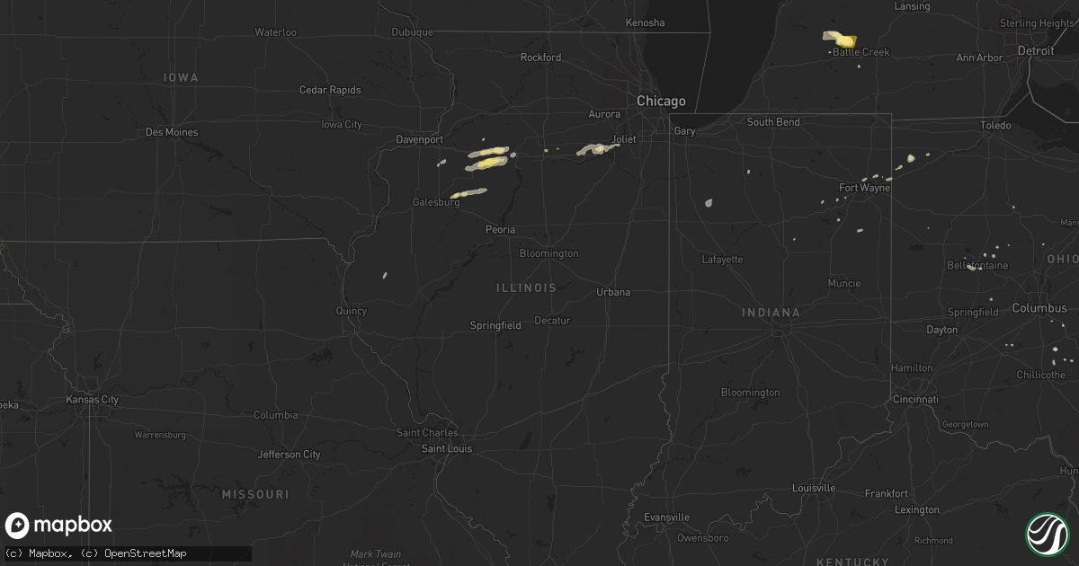
Hail Map in Illinois on June 13, 2015
Get this storm
June 13 map
$229
one time, instant access
Download today. No call, no setup
Keep the $229
Bought the map and want the full workflow? Apply the entire $229 to a subscription within 7 days. None of it is wasted.
Every map, not just this one
This buys you this map. Subscription and you get every map we run, in the markets you choose from a few cities to whole states to nationwide. Plus real-time alerts the moment a storm fires.
Contact data
Name, contact info, occupancy, even credit band for addresses in the footprint. You go from where it hit to who to call.
Become the source they trust
Unlimited branding weather history reports on demand. You already have the documented answer ready for the property owner, and you are the one who showed up with it.
Property data and RoofTrace estimates
Pull up any address you have got, its value and the exact code rules for that jurisdiction, straight from One Click Code. Then RoofTrace estimates the squares, pitch, and roof value, priced the way you price.
Storm reports in Illinois
Illinois
| Date | Description |
|---|---|
| 06/13/20155:00 PM CDT | Snapped 7 inch limbs at charters and winzel road. |
| 06/13/20154:02 PM CDT | Via twitter hail picture. Time estimated based off of radar. |
| 06/13/20153:29 PM CDT | Power lines down on route 6 just east of mineral. Time estimated based on radar. Call came into dipatch at 352 pm. |
| 06/13/20151:21 PM CDT | 2 power poles blown down on buckhart road. |
| 06/12/20158:40 PM CDT | Late report. Power pole snapped off and power lines on the ground on 1500e 1/4 mile north of 1700n. |
| 06/12/20158:40 PM CDT | Late report. Large tree down off 1400e 1/4 mile south of 1700n. |
| 06/12/20158:40 PM CDT | Several power lines...power poles...trees and tree limbs blown down around town. One unoccupied mobile home was blown off of its foundation. |
| 06/12/20158:25 PM CDT | Power pole snapped and powerlines on the ground. |
| 06/12/20157:40 PM CDT | A local report indicates 60 MPH wind near NEBO |
| 06/12/20157:33 PM CDT | Tree down on power line on old jacksonville road. |
| 06/12/20157:26 PM CDT | Tree broken off about 4 feet above ground. Reported via facebook page... With picture. |
All States Impacted by Hail Map on June 13, 2015
Cities Impacted by Hail Map on June 13, 2015
- Lovington, NM
- Tatum, NM
- Menoken, ND
- Onida, SD
- Pierre, SD
- Agar, SD
- Osage, WY
- Newcastle, WY
- Richland, MI
- Delton, MI
- Plainwell, MI
- Hickory Corners, MI
- Battle Creek, MI
- Augusta, MI
- Buffalo, WY
- Pantego, NC
- Selfridge, ND
- Fort Yates, ND
- Gillette, WY
- Manderson, WY
- Alpine, TX
- Suffolk, VA
- Frederick, SD
- Brighton, CO
- Denver, CO
- Commerce City, CO
- Hettinger, ND
- Fraziers Bottom, WV
- Buffalo, WV
- Red House, WV
- Caldwell, OH
- Pleasant City, OH
- Leola, SD
- Moriarty, NM
- Smithfield, VA
- Elberon, VA
- Surry, VA
- Dennison, OH
- Ventress, LA
- New Roads, LA
- Pecos, TX
- Linton, ND
- Hyattville, WY
- Roff, OK
- Neponset, IL
- Princeton, IL
- Tiskilwa, IL
- Sheffield, IL
- Kewanee, IL
- Wyanet, IL
- Buda, IL
- Cubero, NM
- Laguna, NM
- Jal, NM
- Custer, SD
- Elida, NM
- Hereford, TX
- Cheyenne, WY
- Bloomingburg, OH
- Watauga, SD
- McIntosh, SD
- Mcdonald, NM
- Mentone, TX
- Wasta, SD
- Magdalena, NM
- Laurelville, OH
- Napoleon, ND
- Lynn Center, IL
- Artesia, NM
- Winslow, AZ
- Bellefontaine, OH
- Rushsylvania, OH
- Hill City, SD
- Lead, SD
- Seminary, MS
- Hattiesburg, MS
- Upton, WY
- Masterson, TX
- Victoria, IL
- Van Horn, TX
- White Owl, SD
- Gackle, ND
- Stoutsville, OH
- Sundown, TX
- Levelland, TX
- Meadow, TX
- Fort Lupton, CO
- Reedy, WV
- Ropesville, TX
- Hulett, WY
- Alva, WY
- Fort Stockton, TX
- Fort Davis, TX
- Bowen, IL
- Augusta, IL
- Cape Girardeau, MO
- Jackson, MO
- Marathon, TX
- Woodburn, IN
- Dove Creek, CO
- Zuni, VA
- Windsor, VA
- San Jon, NM
- Enning, SD
- Ardmore, OK
- Roanoke, IN
- Morris, IL
- Minooka, IL
- Weldon, CA
- Torrington, WY
- Strasburg, ND
- Plainview, TX
- Clovis, NM
- Whiteface, TX
- Tampico, IL
- Hope, NM
- Mechanicsburg, OH
- Haskell, TX
- Eagle Butte, SD
- Ivor, VA
- Carrsville, VA
- Seminole, TX
- Bismarck, ND
- Moffit, ND
- Sterling, ND
- Bowerston, OH
- Williamsfield, IL
- Huntington, IN
- Platteville, CO
- West Mansfield, OH
- Mineral, IL
- Plains, TX
- Fredonia, ND
- Tohatchi, NM
- Mobridge, SD
- Lockney, TX
- Floydada, TX
- Silverton, TX
- Thoreau, NM
- Defiance, OH
- Knoxville, IL
- Toulon, IL
- Speer, IL
- Wyoming, IL
- San Antonio, NM
- Floyd, NM
- Amherst, TX
- Sudan, TX
- Kintyre, ND
- Albuquerque, NM
- Bosque Farms, NM
- Pleasant View, CO
- Lewistown, OH
- Kress, TX
- Paducah, TX
- Hobbs, NM
- Athens, OH
- The Plains, OH
- Moselle, MS
- Broadus, MT
- New Plymouth, OH
- Floresville, TX
- Ottawa, IL
- Fullerton, ND
- Ellendale, ND
- Washington, NC
- Blounts Creek, NC
- Coffeeville, AL
- Thomasville, AL
- Ney, OH
- Sherwood, OH
- Dupree, SD
- Gruver, TX
- Weston, WY
- Lynchburg, VA
- Amboy, IN
- Jarales, NM
- Sundance, WY
- Denver City, TX
- Seymour, TX
- Upper Sandusky, OH
- Chinle, AZ
- Capitan, NM
- Newark, IL
- East Leroy, MI
- Fort Pierre, SD
- Zachary, LA
- Slaughter, LA
- Liberty, WV
- Given, WV
- Grabill, IN
- Fort Wayne, IN
- Rensselaer, IN
- Crownpoint, NM
- Roswell, NM
- Penhook, VA
- Hazelton, ND
- Westport, SD
- Hicksville, OH
- Banner, WY
- Story, WY
- Spencerville, OH
- Kaycee, WY
- Knox, IN
- Monterey, IN
- Jackson, AL
- Martin, MI
- Shiloh, NC
- Shawboro, NC
- Camden, NC
- Jamestown, ND
- Cleveland, ND
- Littlefield, TX
- Howes, SD
- Kinston, AL
- Samson, AL
- Streeter, ND
- Kyle, SD
- Mount Victory, OH
- Amelia Court House, VA
- Caputa, SD
- Hermosa, SD
- Prattville, AL
- Kingman, AZ
- Golden Valley, AZ
- Kalamazoo, MI
- Pinon, NM
- Utica, IL
- O'Brien, TX
- Knox City, TX
- Brownfield, TX
- Groveport, OH
- Canal Winchester, OH
- Andover, IL
- Cambridge, IL
- Cedar Grove, WV
- Belle, WV
- De Graff, OH
- Stamford, TX
- Channahon, IL
- Joliet, IL
- Circleville, OH
- Baker, LA
- Baton Rouge, LA
- Park Hill, OK
- Wall, SD
- Bluffton, IN
- Waterford, OH
- Lowell, OH
- Nelsonville, OH
- New Underwood, SD
- North Manchester, IN
- Union Center, SD
- Gallup, NM
- Ravenna, TX
- Goree, TX
- La Rue, OH
- Lagrange, WY
- Logan, OH
- Sheridan, WY
- Hesperus, CO
- Wishek, ND
- New Holland, OH
- Washington Court House, OH
- Mott, ND
- New Leipzig, ND
- Kingston, OH
- Collins, MS
- Amarillo, TX
- Florala, AL
- Lubbock, TX
- Brantley, AL
- Luverne, AL
- Wakpala, SD
- Earth, TX
- Elba, AL
- Manlius, IL
- Annawan, IL
- Munday, TX
- Carroll, OH
- Farmington, NM
- Brundidge, AL
- Sturgis, SD
- Pep, NM
- Aladdin, WY
- Cardington, OH
- Seneca, IL
- Marseilles, IL
- Moorcroft, WY
- Dowling, MI


