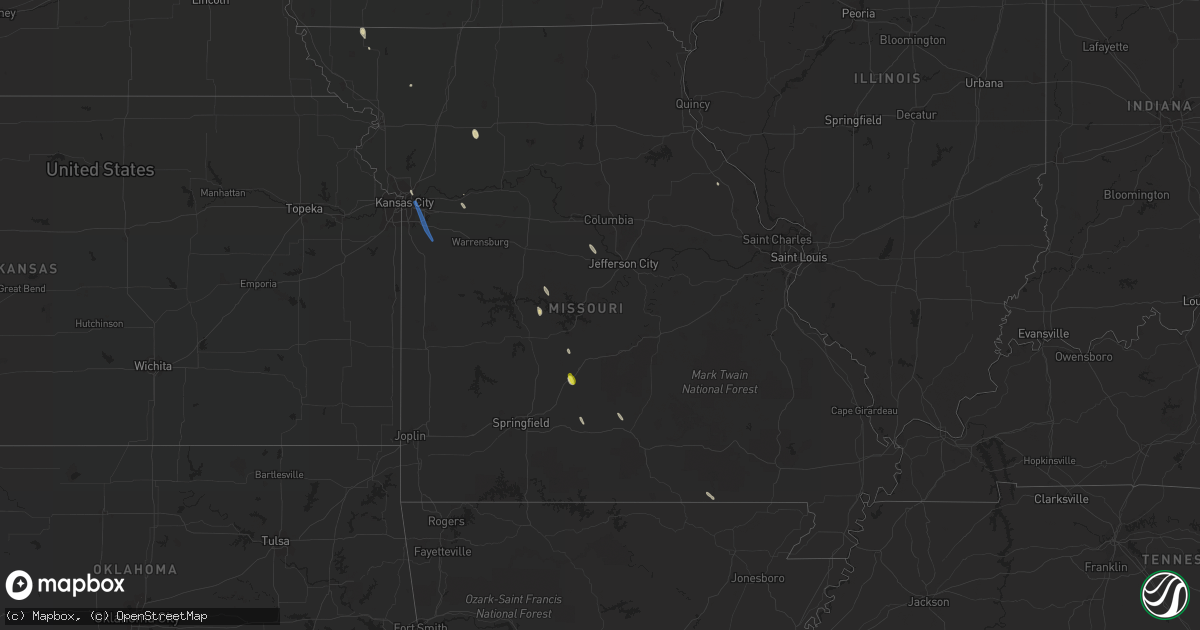
Hail Map in Missouri on June 12, 2019
Get this storm
June 12 map
$229
one time, instant access
Download today. No call, no setup
Keep the $229
Bought the map and want the full workflow? Apply the entire $229 to a subscription within 7 days. None of it is wasted.
Every map, not just this one
This buys you this map. Subscription and you get every map we run, in the markets you choose from a few cities to whole states to nationwide. Plus real-time alerts the moment a storm fires.
Contact data
Name, contact info, occupancy, even credit band for addresses in the footprint. You go from where it hit to who to call.
Become the source they trust
Unlimited branding weather history reports on demand. You already have the documented answer ready for the property owner, and you are the one who showed up with it.
Property data and RoofTrace estimates
Pull up any address you have got, its value and the exact code rules for that jurisdiction, straight from One Click Code. Then RoofTrace estimates the squares, pitch, and roof value, priced the way you price.
Storm reports in Missouri
Missouri
| Date | Description |
|---|---|
| 06/12/20196:45 PM CDT | Leaf litter and small trees limbs down near us 65 and hwy 215. Speed estimated. |
| 06/12/20196:37 PM CDT | Quarter-sized hail reported along i-44 near mile marker 123 near phillipsburg. Time estimated by radar. |
| 06/12/20194:36 PM CDT | Significant tree... 12 to 18 inches in diameter... Down due to thunderstorm winds. |
| 06/12/20194:32 PM CDT | A local report indicates 63 MPH wind near 4 ENE WARRENSBURG |
| 06/12/20194:15 PM CDT | 10 inch diameter tree limb downed. |
| 06/12/20194:02 PM CDT | A local report indicates 64 MPH wind near 2 ENE UNITY VILLAGE |
| 06/12/20194:01 PM CDT | Power outages and minor damage per spotter network. |
| 06/11/201911:13 PM CDT | At 412 PM CDT, severe thunderstorms were located along a line extending from 10 miles south of Mayview to 9 miles northwest of Warrensburg to Lone Jack to Grandview, moving south at 40 mph. HAZARD...60 mph wind gusts and nickel size hail. SOURCE...Radar indicated. IMPACT...Expect damage to roofs, siding, and trees. Locations impacted include... Belton, Raymore, Warrensburg, Harrisonville, Clinton, Peculiar, Windsor, Holden, Adrian, Garden City, Archie, Leeton, Urich, Freeman, Calhoun, Creighton, Chilhowee, East Lynne, Lake Annette and Centerview. |
Cities Impacted by Hail Map on June 12, 2019
- Villisca, IA
- Elliott, IA
- Stanton, IA
- Camp Sherman, OR
- Sisters, OR
- Windsor, MO
- Braymer, MO
- Breckenridge, MO
- Winfield, TN
- Oneida, TN
- King City, MO
- Livingston, TN
- Hilham, TN
- Cocoa, FL
- Clewiston, FL
- Labelle, FL
- Adrian, OR
- Harper, OR
- Prineville, OR
- Couch, MO
- West Palm Beach, FL
- Loxahatchee, FL
- Paulina, OR
- Lebanon, MO
- Conway, MO
- Phillipsburg, MO
- Okeechobee, FL
- Nodaway, IA
- Corning, IA
- Clearmont, MO
- Maupin, OR
- Elmo, MO
- Alpine, TN
- Rickman, TN
- Monroe, TN
- Cookeville, TN
- Eldridge, MO
- Vale, OR
- Maryville, MO
- Edwards, MO
- Hobe Sound, FL
- Dillon, MT
- California, MO
- Cabool, MO
- Mountain Grove, MO
- Mansfield, MO
- Stuart, FL
- Kansas City, MO
- Higginsville, MO
- Seymour, TX
- Murphy, ID
- Lexington, MO
- Goree, TX
- Jamestown, TN
- Mayview, MO
- Odessa, MO
- Wellington, MO
- Melbourne, FL
- Saint Cloud, FL
- Kenansville, FL
- Wellington, FL
- Bowling Green, MO
- Jamestown, MO
- Stover, MO
- Orlando, FL
- Kissimmee, FL
- Greenwood, MO
- Pleasant Hill, MO
- Independence, MO
- Lees Summit, MO


