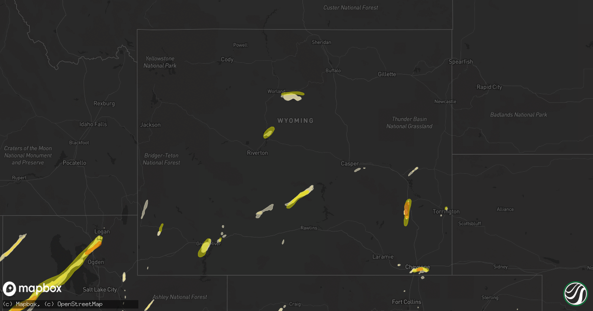
Hail Map in Wyoming on June 12, 2016
Get this storm
June 12 map
$229
one time, instant access
Download today. No call, no setup
Keep the $229
Bought the map and want the full workflow? Apply the entire $229 to a subscription within 7 days. None of it is wasted.
Every map, not just this one
This buys you this map. Subscription and you get every map we run, in the markets you choose from a few cities to whole states to nationwide. Plus real-time alerts the moment a storm fires.
Contact data
Name, contact info, occupancy, even credit band for addresses in the footprint. You go from where it hit to who to call.
Become the source they trust
Unlimited branding weather history reports on demand. You already have the documented answer ready for the property owner, and you are the one who showed up with it.
Property data and RoofTrace estimates
Pull up any address you have got, its value and the exact code rules for that jurisdiction, straight from One Click Code. Then RoofTrace estimates the squares, pitch, and roof value, priced the way you price.
Storm reports in Wyoming
Wyoming
| Date | Description |
|---|---|
| 06/12/20166:45 PM CDT | Heavy rain and hail nickel to quarter size. |
| 06/12/20166:31 PM CDT | A local report indicates 63 MPH wind near TORRINGTON |
| 06/12/20165:45 PM CDT | A local report indicates 58 MPH wind near 1 WNW EVANSTON |
| 06/12/20164:35 PM CDT | A local report indicates 1.00 inch wind near KEMMERER |
| 06/12/20164:31 PM CDT | A local report indicates 1.50 inch wind near 1 W KEMMERER |
| 06/12/20164:30 PM CDT | A local report indicates 1.00 inch wind near KEMMERER |
| 06/12/20164:30 PM CDT | Report received via facebook. |
| 06/12/20164:16 PM CDT | Reported at wheatland reservoir numer 1. |
| 06/12/20164:15 PM CDT | Tennis ball hail reported to fall for a few minutes. |
| 06/12/20164:07 PM CDT | Penny to quarter sized hail |
| 06/12/20163:56 PM CDT | A local report indicates 1.00 inch wind near 7 SW WHEATLAND |
| 06/12/20163:45 PM CDT | Accumulating on the ground and take leaves off of trees |
| 06/12/20162:55 PM CDT | A local report indicates 1.50 inch wind near 2 S CHEYENNE |
| 06/12/20162:47 PM CDT | A local report indicates 1.25 inch wind near 5 S CHEYENNE |
| 06/12/20162:47 PM CDT | A local report indicates 1.25 inch wind near 3 S CHEYENNE |
All States Impacted by Hail Map on June 12, 2016
Cities Impacted by Hail Map on June 12, 2016
- Shoshoni, WY
- Garden City, KS
- De Kalb, TX
- Lawton, OK
- Thedford, NE
- Doniphan, MO
- Fargo, OK
- Ingalls, KS
- Cimarron, KS
- Ensign, KS
- Las Animas, CO
- Rocky Ford, CO
- La Junta, CO
- Dumont, MN
- Chokio, MN
- Graceville, MN
- Pennington, MN
- Falmouth, KY
- Brooksville, KY
- Puposky, MN
- Bemidji, MN
- Wallsburg, UT
- Johnstown, NE
- Yuma, CO
- Otis, CO
- Franklin, VA
- Carrsville, VA
- Suffolk, VA
- Ivor, VA
- Sedley, VA
- Zuni, VA
- Leakesville, MS
- Richton, MS
- Dalton, MN
- Fergus Falls, MN
- Arnett, OK
- Gage, OK
- Ferryville, WI
- Nelson, MN
- Osakis, MN
- Shawnee, WY
- Manville, WY
- Saffell, AR
- Grove City, MN
- Blanchardville, WI
- Mount Horeb, WI
- Drury, MO
- Owenton, KY
- Mount Sterling, IL
- Coalville, UT
- Kerkhoven, MN
- Kit Carson, CO
- Cheyenne Wells, CO
- Wendover, UT
- State Line, MS
- Neely, MS
- Haswell, CO
- Mountain Home, AR
- Grantsville, UT
- Cheyenne, WY
- Hickory Valley, TN
- Sumrall, MS
- Richmond, MN
- Winchester, IL
- Fort Stockton, TX
- Belgrade, MN
- Malone, TX
- Penelope, TX
- Deputy, IN
- Dieterich, IL
- Pewee Valley, KY
- Louisville, KY
- Crestwood, KY
- Neodesha, KS
- Fredonia, KS
- Florence, AL
- Chesapeake, VA
- Dupont, IN
- Butlerville, IN
- Laverne, OK
- Black, MO
- Manzanola, CO
- Forgan, OK
- Livingston, AL
- Paynesville, MN
- Brigham City, UT
- Willard, UT
- Mantua, UT
- Melrose, MN
- Pelican Rapids, MN
- Ozark, MO
- Forsyth, MO
- Georgetown, IN
- Corydon, IN
- Crandall, IN
- New Salisbury, IN
- Lanesville, IN
- Wheatland, WY
- Yoder, CO
- Colorado Springs, CO
- Rush, CO
- Gentry, AR
- Springdale, AR
- Siloam Springs, AR
- Hammon, OK
- Cass Lake, MN
- Benedict, KS
- Mabel, MN
- Decorah, IA
- Dorchester, IA
- Spring Grove, MN
- Norwood, LA
- Grand Junction, TN
- Saulsbury, TN
- Foster, KY
- Grouse Creek, UT
- Waverly, IL
- Abbott, TX
- Hillsboro, TX
- Raleigh, MS
- Miami, OK
- Taylorville, IL
- Stonington, IL
- Herman, MN
- Barrett, MN
- Fort Sill, OK
- Elgin, OK
- Vendor, AR
- Mount Judea, AR
- Vancleave, MS
- Dawson, ND
- Apache, OK
- Lorena, TX
- Waco, TX
- Woodway, TX
- Hewitt, TX
- Belview, MN
- Birch Tree, MO
- Rawlins, WY
- Hines, MN
- Gering, NE
- Mitchell, NE
- Sibley, LA
- Heflin, LA
- Bairoil, WY
- Worland, WY
- Taloga, OK
- Yellville, AR
- Poteau, OK
- Heavener, OK
- Hartford, AR
- Sharon, OK
- Litchfield, MN
- Watkins, MN
- Gate, OK
- Valley Springs, AR
- Bancroft, ID
- Grace, ID
- Blue Mounds, WI
- Barneveld, WI
- Karval, CO
- Sugar City, CO
- Vinita, OK
- Highland, WI
- Bartlett, KS
- Ava, MO
- Evansville, MN
- Brandon, MN
- Big Springs, NE
- Varnville, SC
- Craig, CO
- Idabel, OK
- Haworth, OK
- Wood Lake, NE
- Pelsor, AR
- Walters, OK
- Crawfordville, FL
- Effie, MN
- Big Falls, MN
- Glenham, SD
- Torrington, WY
- Foxhome, MN
- Swink, CO
- Noel, MO
- Bella Vista, AR
- Hanceville, AL
- Cullman, AL
- Bluffs, IL
- Chapin, IL
- Arlington, TN
- Memphis, TN
- Moody, TX
- McGregor, TX
- Cook, MN
- Angora, MN
- Cokeville, WY
- Gates, NC
- Wakefield, VA
- Jeffersonville, IN
- Prospect, KY
- Rome, GA
- Wamsutter, WY
- Aquilla, TX
- Valley Mills, TX
- West, TX
- China Spring, TX
- Boone, CO
- New Glarus, WI
- Beaver, OK
- Conroe, TX
- Beaumont, MS
- Peyton, CO
- Brooksville, FL
- Eucha, OK
- Spavinaw, OK
- Ordway, CO
- Corolla, NC
- Chamberlain, SD
- Olney Springs, CO
- Assumption, IL
- Lansing, IA
- Waukon, IA
- Normangee, TX
- Mineral Springs, AR
- Nashville, AR
- Centerton, AR
- Bentonville, AR
- Winona, KS
- Flora, IL
- Pittsfield, IL
- Chetopa, KS
- Welch, OK
- Bear Creek, AL
- Corinth, MS
- Pineville, MO
- Lakewood, IL
- Shelbyville, IL
- Eckley, CO
- Elizabeth, IN
- Clifton, TX
- Ogden, UT
- Wellsville, UT
- Prairie Grove, AR
- Holly Grove, AR
- Whitney, TX
- Elm Mott, TX
- Temple, TX
- Bruceville, TX
- Blum, TX
- Crawford, TX
- Ibapah, UT
- Anderson, MO
- Kelly, LA
- Tribune, KS
- Lamar, MO
- Steele, AL
- Montello, NV
- Thayer, KS
- Eyota, MN
- Dover, MN
- Newton, IL
- Wheeler, IL
- Imperial, NE
- Green River, WY
- Thomasville, AL
- Nunn, CO
- Shattuck, OK
- Hoffman, MN
- Kensington, MN
- Beardsley, MN
- Wheaton, MN
- Browns Valley, MN
- New Effington, SD
- Rosholt, SD
- Peever, SD
- Sisseton, SD
- Rock Springs, WY
- Dawson, TX
- Girard, KS
- Downey, ID
- Lava Hot Springs, ID
- Eads, CO
- Valentine, NE
- Liberty, MS
- Breckenridge, MN
- Mccomb, MS
- Harpers Ferry, IA
- Fort Collins, CO
- Lone Rock, WI
- Greeley, CO
- Foreman, AR
- Tenstrike, MN
- May, OK
- Syracuse, KS
- Hanna, UT
- Roosevelt, UT
- Ashland, MS
- Holly Springs, MS
- Crandall, TX
- Jackson, LA
- Ethel, LA
- Chanute, KS
- Saint Charles, AR
- Ethel, AR
- Potts Camp, MS
- Sauk Centre, MN
- Fort Cobb, OK
- Anadarko, OK
- Effingham, IL
- Lake Norden, SD
- Cedarcreek, MO
- Hyrum, UT
- Morris, MN
- Cyrus, MN
- Rochester, MN
- Protem, MO
- Itasca, TX
- Milford, TX
- Paradise, UT
- Bradleyville, MO
- West Union, MN
- Haleyville, AL
- Farwell, MN
- Starbuck, MN
- Glenwood, MN
- Lowry, MN
- Donnelly, MN
- Tryon, NE
- Mountain Iron, MN
- Leedey, OK
- Elgin, IA
- Sharon Springs, KS
- Jasper, AR
- Vici, OK
- Woodward, OK
- Camargo, OK
- Butler, OK
- Virginia Beach, VA
- Waggoner, IL
- Marathon, TX
- Decatur, AL
- Huntsville, AL
- Fort Pierre, SD
- Lanagan, MO
- Dallas, TX
- Carrollton, TX
- Timewell, IL
- Pukwana, SD
- Meridian, MS
- Wray, CO
- Streetman, TX
- Arlington, CO
- Kent, MN
- Rothsay, MN
- Wahpeton, ND
- Iuka, MS
- Akron, CO
- Pennock, MN
- Gays Mills, WI
- Grandview, TX
- Genoa, CO
- Palmyra, IL
- Rush Springs, OK
- Marlow, OK
- Brooten, MN
- Hardy, AR
- Williford, AR
- Peoa, UT
- New Albany, IN
- Eden Valley, MN
- Lynn, AL
- Logan, AL
- Hankinson, ND
- Maypearl, TX
- Bowie, TX
- Alvord, TX
- Sunset, TX
- Kandiyohi, MN
- Blue Mountain, MS
- Hickory Flat, MS
- Franklin, AR
- Thurmond, WV
- Evening Shade, AR
- Horseshoe Bend, AR
- Sage, AR
- De Queen, AR
- Alma Center, WI
- Athens, AL
- Benkelman, NE
- Ely, NV
- Clayton, OK
- Willow Lake, SD
- Carpenter, SD
- McHenry, MS
- Perkinston, MS
- Hayden, AL
- Stewardson, IL
- Beecher City, IL
- Mexia, TX
- Scottsburg, IN
- Geronimo, OK
- Faxon, OK
- Wolverton, MN
- Subiaco, AR
- Fayetteville, WV
- Duncan, OK
- Greenville, IN
- Elbow Lake, MN
- Ashby, MN
- Pittsburg, KS
- Palmyra, IN
- Cleveland, AL
- Casper, WY
- Wilmot, SD
- Prichard, WV
- Wayne, WV
- Houston, TX
- Bellaire, TX
- Atwater, MN
- Wallace, KS
- Bridgeport, NE
- Canadian, TX
- Fort Smith, AR
- Montgomery, TX
- Clarksville, TX
- Bagwell, TX
- Calhan, CO
- Ridgeway, IA
- Cresco, IA
- Leighton, AL
- Soda Springs, ID
- Saint Francisville, LA
- Norfork, AR
- Calico Rock, AR
- Falkville, AL
- Danville, AL
- Corinne, UT
- Saucier, MS
- Biloxi, MS
- Tahlequah, OK
- Burnsville, MS
- Myrtle, MS
- Cheyenne, OK
- Snow, OK
- Almyra, AR
- Bynum, TX
- Madison, AL
- Wortham, TX
- Riverton, WY
- Crowheart, WY
- Kinnear, WY
- Pavillion, WY
- Blackduck, MN
- Sheridan Lake, CO
- Holly, CO
- Hugoton, KS
- Marienthal, KS
- Deerfield, KS
- Spicer, MN
- Shreveport, LA
- New London, MN
- Weskan, KS
- Clayton, IL
- Sutherland, NE
- Virden, IL
- Vinemont, AL
- Laconia, IN
- Rushville, IL
- Darwin, MN
- Hutchinson, MN
- Lake Butler, FL
- Erhard, MN
- Campbell, MN
- Fairmount, ND
- Melbourne, AR
- Meredosia, IL
- Scurry, TX
- Kaufman, TX
- Osseo, MN
- Maple Grove, MN
- Russellville, AR
- Hector, AR
- Glenview, KY
- Charlestown, IN
- Spring Green, WI
- Brockwell, AR
- Mountain View, AR
- Ridgeway, WI
- Fairview, UT
- North Vernon, IN
- Kamas, UT
- Enders, NE
- Canton, SD
- Worthing, SD
- Higgins, TX
- Sandy Hook, KY
- Elkfork, KY
- Blountsville, AL
- Gainesville, MO
- Barnesville, MN
- Calhoun, LA
- Sparta, GA
- Seneca, MO
- Heber City, UT
- San Augustine, TX
- Floyds Knobs, IN
- Dawson, MN
- Strawberry, AR
- Evanston, WY
- Silver Lake, MN
- Glencoe, MN
- Alexandria, MN
- Waxahachie, TX
- Italy, TX
- Olla, LA
- Logan, UT
- Montrose, MO
- Forestburg, TX
- De Witt, AR
- Austin, AR
- Ward, AR
- Marshall, AR
- Kimball, MN
- Dassel, MN
- Roscoe, MN
- Republic, MO
- Brookline, MO
- Ortonville, MN
- Clinton, MN
- Clarksdale, MS
- Tutwiler, MS
- Beresford, SD
- Selby, SD
- Mound City, SD
- Medicine Park, OK
- Dry Ridge, KY
- Coolidge, TX
- Krum, TX
- Ponder, TX
- Glenrock, WY
- Montevideo, MN
- Maynard, MN
- Otisco, IN
- Carlinville, IL
- Bayard, NE
- Alcova, WY
- Fifty Six, AR
- Norcross, MN
- Barry, MN
- Villard, MN
- Elgin, MN
- Valley City, ND
- Lead Hill, AR
- Altoona, AL
- Boscobel, WI
- Pawnee, IL
- Muscoda, WI
- Blue River, WI
- Comanche, OK
- Lake Preston, SD
- Bassfield, MS
- Midway, AR
- Dawsonville, GA
- Chelsea, OK
- Nowata, OK
- Kissee Mills, MO
- Cape Charles, VA
- Machipongo, VA
- Clark, SD
- Leola, SD
- Frederick, SD
- Kincaid, IL
- Collins, MS
- Kiowa, CO
- Elbert, CO
- Butler, AL
- Lake City, FL
- Lulu, FL
- Ramsey, IN
- New Middletown, IN
- Grand Cane, LA
- Mansfield, LA
- Winton, NC
- Cofield, NC
- West Monroe, LA
- Ramer, TN
- Lockwood, MO
- Bronson, FL
- Chiefland, FL
- Caledonia, MN
- Lacombe, LA
- Beaufort, SC
- Ten Sleep, WY
- Hamilton, AL
- Hackleburg, AL
- Altus, AR
- Coal Hill, AR
- Crawfordsville, AR
- Trinity, AL
- Dallas, GA
- Madison, MN
- Parkers Prairie, MN
- Labolt, SD
- Elk City, KS
- Moyers, OK
- Antlers, OK
- Catlettsburg, KY
- Huntington, WV
- Kenova, WV
- Waterville, IA
- Lincoln, AR
- Vernon, CO
- Saint Joe, AR
- Monona, IA
- Johnson, KS
- Cheraw, CO
- Fountain, CO
- Hubbard, TX
- Mount Calm, TX
- Walhalla, ND
- Pana, IL
- Axtell, TX
- Athens, GA
- West Liberty, KY
- Kemmerer, WY
- Diamondville, WY
- Dugway, UT
- West Wendover, NV


