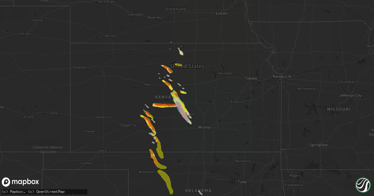
Hail Map in Kansas on June 11, 2019
Get this storm
June 11 map
$229
one time, instant access
Download today. No call, no setup
Keep the $229
Bought the map and want the full workflow? Apply the entire $229 to a subscription within 7 days. None of it is wasted.
Every map, not just this one
This buys you this map. Subscription and you get every map we run, in the markets you choose from a few cities to whole states to nationwide. Plus real-time alerts the moment a storm fires.
Contact data
Name, contact info, occupancy, even credit band for addresses in the footprint. You go from where it hit to who to call.
Become the source they trust
Unlimited branding weather history reports on demand. You already have the documented answer ready for the property owner, and you are the one who showed up with it.
Property data and RoofTrace estimates
Pull up any address you have got, its value and the exact code rules for that jurisdiction, straight from One Click Code. Then RoofTrace estimates the squares, pitch, and roof value, priced the way you price.
Storm reports in Kansas
Kansas
| Date | Description |
|---|---|
| 06/11/20196:59 PM CDT | Spotter report of half dollar size hail 4 miles north northwest of kinsley. |
| 06/11/20196:50 PM CDT | Spotter report of half dollar size hail 5 miles north northwest of kinsley. |
| 06/11/20196:30 PM CDT | Delayed report of roughly 10 minutes of hail up to half dollar size from approx. 630-640 pm. |
| 06/11/20196:25 AM CDT | At 1125 PM CDT, a severe thunderstorm was located 6 miles south of Haven, moving southeast at 35 mph. HAZARD...60 mph wind gusts and quarter size hail. SOURCE...Radar indicated. IMPACT...Hail damage to vehicles is expected. Expect wind damage to roofs, siding, and trees. Locations impacted include... Goddard, Cheney, Haven, Garden Plain, Mount Hope, Andale, Lake Afton, Cheney Lake, Mt Vernon and Cheney State Park. |
| 06/11/20196:03 AM CDT | At 1103 PM CDT, a severe thunderstorm was located near Lyons, moving southeast at 25 mph. HAZARD...60 mph wind gusts and half dollar size hail. SOURCE...Radar indicated. IMPACT...Hail damage to vehicles is expected. Expect wind damage to roofs, siding, and trees. Locations impacted include... Lyons, Sterling and Little River. |
| 06/11/20195:27 AM CDT | At 1027 PM CDT, a severe thunderstorm was located near Sterling, moving southeast at 35 mph. HAZARD...60 mph wind gusts and half dollar size hail. SOURCE...Radar indicated. IMPACT...Hail damage to vehicles is expected. Expect wind damage to roofs, siding, and trees. Locations impacted include... Hutchinson, South Hutchinson, Buhler, Haven, Nickerson, Arlington, Partridge, Abbyville, Yoder, Willowbrook and Hutchinson Airport. |
| 06/11/20195:06 AM CDT | At 1006 PM CDT, a severe thunderstorm was located near Lyons, moving southeast at 40 mph. HAZARD...60 mph wind gusts and half dollar size hail. SOURCE...Radar indicated. IMPACT...Hail damage to vehicles is expected. Expect wind damage to roofs, siding, and trees. Locations impacted include... Lyons, Sterling, Chase, Alden and Raymond. |
| 06/11/20194:59 AM CDT | At 959 PM CDT, a severe thunderstorm was located near Montrose, or 20 miles north of Beloit, moving southeast at 20 mph. HAZARD...60 mph wind gusts and half dollar size hail. SOURCE...Radar indicated. IMPACT...Hail damage to vehicles is expected. Expect wind damage to roofs, siding, and trees. Locations impacted include... Jewell, Randall, Scottsville and Montrose. |
| 06/11/20194:49 AM CDT | At 949 PM CDT, a severe thunderstorm was located 7 miles northeast of Nickerson, moving southeast at 30 mph. HAZARD...60 mph wind gusts and quarter size hail. SOURCE...Radar indicated. IMPACT...Hail damage to vehicles is expected. Expect wind damage to roofs, siding, and trees. Locations impacted include... Hutchinson, South Hutchinson, Buhler, Haven, Nickerson, Burrton, Yoder, Willowbrook and Hutchinson Airport. |
| 06/11/20194:35 AM CDT | At 935 PM CDT, a severe thunderstorm was located 8 miles northwest of Holyrood, or 10 miles north of Claflin, moving southeast at 45 mph. HAZARD...Half dollar size hail. SOURCE...Radar indicated. IMPACT...Damage to vehicles is expected. Locations impacted include... Holyrood, Bushton, Geneseo, Lorraine, Frederick and Kanopolis Lake. |
| 06/11/20194:15 AM CDT | At 915 PM CDT, a severe thunderstorm was located near Aetna, moving southeast at 35 mph. HAZARD...Ping pong ball size hail and 60 mph wind gusts. SOURCE...Radar indicated. IMPACT...People and animals outdoors will be injured. Expect hail damage to roofs, siding, windows, and vehicles. Expect wind damage to roofs, siding, and trees. Locations impacted include... Aetna. |
| 06/11/20194:01 AM CDT | At 901 PM CDT, a severe thunderstorm was located near Lorraine, or 12 miles northwest of Lyons, moving southeast at 20 mph. HAZARD...60 mph wind gusts and half dollar size hail. SOURCE...Radar indicated. IMPACT...Hail damage to vehicles is expected. Expect wind damage to roofs, siding, and trees. Locations impacted include... Lyons, Sterling, Little River, Chase, Bushton, Geneseo, Alden and Frederick. |
| 06/11/20193:56 AM CDT | At 856 PM CDT, a severe thunderstorm was located 6 miles east of Kanopolis, moving east at 35 mph. HAZARD...Ping pong ball size hail and 60 mph wind gusts. SOURCE...Radar indicated. IMPACT...People and animals outdoors will be injured. Expect hail damage to roofs, siding, windows, and vehicles. Expect wind damage to roofs, siding, and trees. Locations impacted include... Salina, Lindsborg, Brookville, Smolan, Falun, Kanopolis Lake, Salina Airport and Kanopolis State Park. |
| 06/11/20193:39 AM CDT | At 839 PM CDT, a severe thunderstorm was located 7 miles southwest of Sun City, moving southeast at 20 mph. HAZARD...Two inch hail and 60 mph wind gusts. SOURCE...Radar indicated. IMPACT...People and animals outdoors will be injured. Expect hail damage to roofs, siding, windows, and vehicles. Expect wind damage to roofs, siding, and trees. Locations impacted include... Sun City and Aetna. |
| 06/11/20193:12 AM CDT | At 812 PM CDT, a severe thunderstorm was located very near Haviland, moving southeast at 20 mph. HAZARD...Tennis ball size hail and 60 mph wind gusts. SOURCE...Radar indicated. IMPACT...People and animals outdoors will be injured. Expect hail damage to roofs, siding, windows, and vehicles. Expect wind damage to roofs, siding, and trees. Locations impacted include... Greensburg, Haviland, Sun City, Wellsford, Croft and Belvidere. |
| 06/11/20193:10 AM CDT | At 810 PM CDT, a severe thunderstorm was located near Wilson, moving southeast at 25 mph. HAZARD...Ping pong ball size hail and 60 mph wind gusts. SOURCE...Radar indicated. IMPACT...People and animals outdoors will be injured. Expect hail damage to roofs, siding, windows, and vehicles. Expect wind damage to roofs, siding, and trees. Locations impacted include... Holyrood, Geneseo and Lorraine. |
| 06/11/20193:01 AM CDT | At 801 PM CDT, a severe thunderstorm was located near Trousdale, moving southeast at 30 mph. HAZARD...Ping pong ball size hail and 60 mph wind gusts. SOURCE...Radar indicated. IMPACT...People and animals outdoors will be injured. Expect hail damage to roofs, siding, windows, and vehicles. Expect wind damage to roofs, siding, and trees. Locations impacted include... Pratt, Iuka, Cullison, Byers, Trousdale and Hopewell. |
| 06/11/20192:59 AM CDT | At 759 PM CDT, a severe thunderstorm was located near Ellinwood, moving east at 30 mph. HAZARD...Ping pong ball size hail and 60 mph wind gusts. SOURCE...Radar indicated. IMPACT...People and animals outdoors will be injured. Expect hail damage to roofs, siding, windows, and vehicles. Expect wind damage to roofs, siding, and trees. Locations impacted include... Lyons, Sterling, Ellinwood, Little River, Chase, Alden, Raymond and Silica. |
| 06/11/20192:29 AM CDT | At 729 PM CDT, a severe thunderstorm was located very near Centerview, moving southeast at 20 mph. HAZARD...Golf ball size hail and 60 mph wind gusts. SOURCE...Radar indicated. IMPACT...People and animals outdoors will be injured. Expect hail damage to roofs, siding, windows, and vehicles. Expect wind damage to roofs, siding, and trees. Locations impacted include... Haviland, Fellsburg, Centerview and Trousdale. |
| 06/11/20192:26 AM CDT | At 725 PM CDT, a severe thunderstorm was located near Pawnee Rock, or 9 miles east of Ash Valley, moving east at 25 mph. HAZARD...Golf ball size hail and 60 mph wind gusts. SOURCE...Radar indicated. IMPACT...People and animals outdoors will be injured. Expect hail damage to roofs, siding, windows, and vehicles. Expect wind damage to roofs, siding, and trees. This severe thunderstorm will remain over mainly rural areas of northeastern Pawnee and north central Stafford Counties. |
| 06/11/20192:24 AM CDT | At 724 PM CDT, a severe thunderstorm was located over Pawnee Rock, or 7 miles northeast of Larned, moving east at 20 mph. HAZARD...Ping pong ball size hail and 60 mph wind gusts. SOURCE...Radar indicated. IMPACT...People and animals outdoors will be injured. Expect hail damage to roofs, siding, windows, and vehicles. Expect wind damage to roofs, siding, and trees. Locations impacted include... Great Bend and Pawnee Rock. |
| 06/11/20192:18 AM CDT | At 718 PM CDT, a severe thunderstorm was located near Garfield, moving southeast at 20 mph. HAZARD...Golf ball size hail and 60 mph wind gusts. SOURCE...Radar indicated. IMPACT...People and animals outdoors will be injured. Expect hail damage to roofs, siding, windows, and vehicles. Expect wind damage to roofs, siding, and trees. Locations impacted include... Lewis, Garfield, Belpre and Zook. |
| 06/11/20192:15 AM CDT | At 715 PM CDT, a severe thunderstorm was located 7 miles northeast of Russell, moving southeast at 25 mph. HAZARD...60 mph wind gusts and half dollar size hail. SOURCE...Radar indicated. IMPACT...Hail damage to vehicles is expected. Expect wind damage to roofs, siding, and trees. Locations impacted include... Russell, Dorrance, Bunker Hill, Russell Airport and Wilson Lake. This includes Interstate 70 between Mile Markers 185 and 202. |
| 06/11/20191:58 AM CDT | At 657 PM CDT, a severe thunderstorm was located 7 miles south of Osborne, or 30 miles west of Beloit, moving southeast at 25 mph. HAZARD...60 mph wind gusts and half dollar size hail. SOURCE...Radar indicated. IMPACT...Hail damage to vehicles is expected. Expect wind damage to roofs, siding, and trees. Locations impacted include... Lincoln, Lucas, Sylvan Grove, Luray, Ash Grove, Westfall, Wilson State Park and Wilson Lake.This includes Interstate 70 between Mile Markers 229 and 235. |
| 06/11/20191:43 AM CDT | At 642 PM CDT, a severe thunderstorm was located 8 miles west of Tipton, or 29 miles west of Beloit, moving southeast at 25 mph. HAZARD...Ping pong ball size hail and 60 mph wind gusts. SOURCE...Radar indicated. IMPACT...People and animals outdoors will be injured. Expect hail damage to roofs, siding, windows, and vehicles. Expect wind damage to roofs, siding, and trees. Locations impacted include... Hunter, but mainly rural southeastern Osborne and southwestern Mitchell Counties. |
| 06/11/20191:27 AM CDT | At 626 PM CDT, a severe thunderstorm was located 7 miles northwest of Kinsley, moving east southeast at 20 mph. HAZARD...60 mph wind gusts and half dollar size hail. SOURCE...Radar indicated. IMPACT...Hail damage to vehicles is expected. Expect wind damage to roofs, siding, and trees. Locations impacted include... Kinsley, Lewis and Centerview. |
| 06/11/20191:19 AM CDT | At 618 PM CDT, a severe thunderstorm was located a few miles southwest of Osborne, or 33 miles north of Russell, moving southeast at 25 mph. HAZARD...60 mph wind gusts and quarter size hail. SOURCE...Radar indicated. IMPACT...Hail damage to vehicles is expected. Expect wind damage to roofs, siding, and trees. Locations impacted include... Osborne, and mainly rural central and east-central Osborne County. |
| 06/10/201910:54 PM CDT | . |
| 06/10/201910:42 PM CDT | Strong winds downed a large tree. Also had dime to nickel size hail. |
| 06/10/201910:33 PM CDT | . |
| 06/10/201910:30 PM CDT | . |
| 06/10/20199:44 PM CDT | A local report indicates 1.00 inch wind near HOLYROOD |
| 06/10/20199:23 PM CDT | Spotter report of quarter size hail. |
| 06/10/20199:15 PM CDT | A local report indicates 60 MPH wind near 5 N CHASE |
| 06/10/20199:12 PM CDT | A local report indicates 1.00 inch wind near FREDERICK |
| 06/10/20198:48 PM CDT | A local report indicates 1.25 inch wind near 5 SW ELLSWORTH |
| 06/10/20198:45 PM CDT | Spotter report of ping pong ball size hail southwest of sun city. |
| 06/10/20198:42 PM CDT | . |
| 06/10/20198:23 PM CDT | A local report indicates 1.50 inch wind near 2 SW CHASE |
| 06/10/20198:15 PM CDT | Social media report of ping pong ball size hail in haviland. |
| 06/10/20198:11 PM CDT | Spotter report of quarter size hail 1 miles southwest of haviland. |
| 06/10/20198:05 PM CDT | A local report indicates 1.00 inch wind near 1 S ELLINWOOD |
| 06/10/20198:00 PM CDT | Spotter report of ping pong ball size hail northeast of trousdale. |
| 06/10/20197:55 PM CDT | A local report indicates 1.75 inch wind near 4 SSE GREAT BEND |
| 06/10/20197:49 PM CDT | A local report indicates 1.50 inch wind near DORRANCE |
| 06/10/20197:41 PM CDT | . |
| 06/10/20197:40 PM CDT | Social media report of ping pong size hail reported on hwy 56 southwest of garfield. |
| 06/10/20197:35 PM CDT | Social media report of golf ball size hail southeast of kinsley. |
| 06/10/20197:30 PM CDT | . |
| 06/10/20197:30 PM CDT | Social media report of golf ball size hail southeast of kinsley. |
| 06/10/20197:27 PM CDT | A local report indicates 1.75 inch wind near 3 N PAWNEE ROCK |
| 06/10/20197:25 PM CDT | Spotter report of quarter size hail southeast of kinsley near centerview. |
| 06/10/20197:08 PM CDT | Spotter report of golf ball size hail 1 mile northwest of kinsley. |
| 06/10/20197:07 PM CDT | Noaa employee reported ping pong size hail at hwy 183/56. |
All States Impacted by Hail Map on June 11, 2019
Cities Impacted by Hail Map on June 11, 2019
- Wessington Springs, SD
- Silverton, TX
- Vinson, OK
- Hollis, OK
- Gould, OK
- Sterling, KS
- Osborne, KS
- Freedom, OK
- Wentworth, SD
- Madison, SD
- Ellsworth, KS
- Garrison, ND
- Geneseo, KS
- Mount Hope, KS
- Wilson, KS
- South Hutchinson, KS
- Little River, KS
- Haven, KS
- Lorraine, KS
- Partridge, KS
- Nickerson, KS
- Bushton, KS
- Hutchinson, KS
- Holyrood, KS
- Burrton, KS
- Pretty Prairie, KS
- Chase, KS
- Lyons, KS
- Verden, OK
- Chickasha, OK
- Wellington, TX
- Pawnee Rock, KS
- Bismarck, ND
- Verona, ND
- Vernon, TX
- Crowell, TX
- Chillicothe, TX
- Bunker Hill, KS
- Dorrance, KS
- Chester, SD
- Colton, SD
- Temple, OK
- Walters, OK
- Matador, TX
- Flomot, TX
- Highmore, SD
- Kinsley, KS
- Lewis, KS
- Nisswa, MN
- Larned, KS
- Headrick, OK
- Sylvan Grove, KS
- Lucas, KS
- Quanah, TX
- Eldorado, OK
- Garfield, KS
- Tipton, OK
- Rozel, KS
- Offerle, KS
- Minneota, MN
- Greensburg, KS
- Haviland, KS
- Blair, OK
- Frederick, OK
- Ghent, MN
- Lynd, MN
- Munday, TX
- Mankato, KS
- Jewell, KS
- Altus, OK
- Seymour, TX
- Blanchard, ND
- Galesburg, ND
- Hillsboro, ND
- Olustee, OK
- Mangum, OK
- Elmer, OK
- Duke, OK
- Altus Afb, OK
- Davidson, OK
- Kanopolis, KS
- Marquette, KS
- Loxahatchee, FL
- Wellington, FL
- Holabird, SD
- Pine River, MN
- Great Bend, KS
- Wilmore, KS
- Motley, MN
- Staples, MN
- Paradise, KS
- Colman, SD
- Dell Rapids, SD
- Kennebec, SD
- Fort Ransom, ND
- Gleason, WI
- Russell, MN
- Marshall, MN
- Ellinwood, KS
- St John, KS
- Jesup, GA
- Iron, MN
- Raymond, KS
- Alden, KS
- Hudson, KS
- De Smet, SD
- Walker, MN
- Alva, OK
- Edmond, OK
- Belpre, KS
- Knox City, TX
- Lincoln, KS
- Aurora, MN
- Makinen, MN
- Hartford, SD
- Sioux Falls, SD
- Crooks, SD
- Glen Elder, KS
- Hilliard, FL
- Iroquois, SD
- Brookville, KS
- Russell, KS
- Lisbon, ND
- Hibbing, MN
- Milesville, SD
- Eveleth, MN
- El Reno, OK
- Minco, OK
- Pocasset, OK
- Baltic, SD
- Quitaque, TX
- Dacoma, OK
- Sun City, KS
- Guthrie, OK
- Bagley, MN
- Isabella, MN
- Finland, MN
- Ellendale, ND
- Snyder, OK
- Plankinton, SD
- Rule, TX
- Luray, KS
- Adrian, MN
- Park Rapids, MN
- Sturgis, SD
- Fort Meade, SD
- Irma, WI
- West Palm Beach, FL
- Lebanon, KS
- Red Cloud, NE
- Rochester, TX
- Brainerd, MN
- Lockney, TX
- Hunter, KS
- Tipton, KS
- Beloit, KS
- Otis, KS
- Lake City, KS
- Inman, KS
- Mooreland, OK
- Coldwater, KS
- Waynoka, OK
- Aline, OK
- Carmen, OK
- Fairview, OK
- Chester, OK
- Seiling, OK
- Canton, OK
- Watonga, OK
- Longdale, OK
- Hinton, OK
- Calumet, OK
- Abbyville, KS
- Baudette, MN


