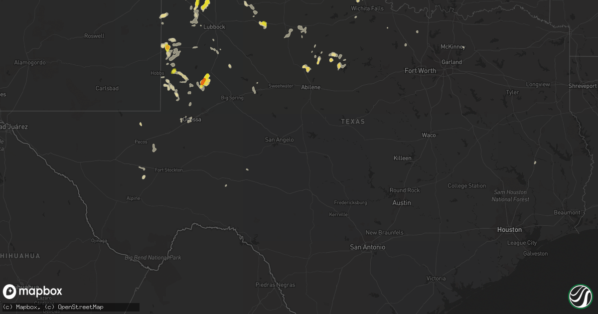
Hail Map in Texas on June 11, 2016
Get this storm
June 11 map
$229
one time, instant access
Download today. No call, no setup
Keep the $229
Bought the map and want the full workflow? Apply the entire $229 to a subscription within 7 days. None of it is wasted.
Every map, not just this one
This buys you this map. Subscription and you get every map we run, in the markets you choose from a few cities to whole states to nationwide. Plus real-time alerts the moment a storm fires.
Contact data
Name, contact info, occupancy, even credit band for addresses in the footprint. You go from where it hit to who to call.
Become the source they trust
Unlimited branding weather history reports on demand. You already have the documented answer ready for the property owner, and you are the one who showed up with it.
Property data and RoofTrace estimates
Pull up any address you have got, its value and the exact code rules for that jurisdiction, straight from One Click Code. Then RoofTrace estimates the squares, pitch, and roof value, priced the way you price.
Storm reports in Texas
Texas
| Date | Description |
|---|---|
| 06/11/20166:10 PM CDT | Measured by the texas tech university west texas mesonet |
| 06/10/201610:33 PM CDT | A local report indicates 1.00 inch wind near 6 W SEMINOLE |
| 06/10/201610:15 PM CDT | A local report indicates 64 MPH wind near 2 NNE SEMINOLE |
| 06/10/20169:34 PM CDT | A local report indicates 1.00 inch wind near 6 W SEMINOLE |
| 06/10/20168:01 PM CDT | Four power poles down between littlefield and bainer on us highway 84 |
| 06/10/20167:45 PM CDT | Measured by the texas tech university west texas mesonet |
| 06/10/20167:41 PM CDT | A local report indicates 75 MPH wind near LITTLEFIELD |
All States Impacted by Hail Map on June 11, 2016
Cities Impacted by Hail Map on June 11, 2016
- Lindsay, OK
- Milnesand, NM
- Farmersville, TX
- Dickens, TX
- Rolfe, IA
- Gilmore City, IA
- Miles City, MT
- Morton, TX
- Tahoka, TX
- Drake, ND
- Medicine Park, OK
- Lawton, OK
- Cohagen, MT
- Hinsdale, MT
- Opheim, MT
- Whitman, NE
- Hale Center, TX
- Wittmann, AZ
- Otter, MT
- Union Springs, AL
- Odessa, TX
- Ismay, MT
- Terry, MT
- Kinsey, MT
- Volborg, MT
- Mcadoo, TX
- Tarzan, TX
- Lamesa, TX
- Haskell, TX
- Forsyth, MT
- Richland, MT
- Peerless, MT
- Trail City, SD
- Stamford, TX
- Throckmorton, TX
- Hudson, WI
- Abernathy, TX
- Littlefield, TX
- Anton, TX
- Springer, OK
- Ardmore, OK
- River Falls, WI
- Prescott, WI
- Birmingham, AL
- Plains, TX
- Makoti, ND
- Purcell, OK
- Maysville, OK
- Wayne, OK
- Belfield, ND
- Medora, ND
- Fairfield, ND
- Reva, SD
- Roff, OK
- Ada, OK
- Roswell, NM
- Wakpala, SD
- McLaughlin, SD
- Seminole, TX
- Mentone, TX
- Apache, OK
- Elgin, OK
- Winkelman, AZ
- Randlett, OK
- Sand Springs, MT
- Alexander, ND
- Bay City, WI
- Red Wing, MN
- Hager City, WI
- Welch, MN
- Ninnekah, OK
- Rush Springs, OK
- Sulphur, OK
- Davis, OK
- Andrews, TX
- Amber, OK
- Bradley, OK
- Alex, OK
- Blanchard, OK
- Chickasha, OK
- Anadarko, OK
- Fort Cobb, OK
- Plantersville, AL
- Lodgepole, SD
- Levelland, TX
- Oakman, AL
- Cache, OK
- Fort Davis, AL
- Hardaway, AL
- Fitzpatrick, AL
- Fieldton, TX
- Amherst, TX
- Iowa Park, TX
- Parshall, ND
- Roseglen, ND
- Ryder, ND
- Tucson, AZ
- Arthur, NE
- Colony, OK
- Bode, IA
- Ottosen, IA
- Algona, IA
- West Bend, IA
- Carbon Hill, AL
- Townley, AL
- Cascade, IA
- Denver City, TX
- Pollock, SD
- Strasburg, ND
- Martin, ND
- Anamoose, ND
- Ross, ND
- Walters, OK
- Montgomery, AL
- Fay, OK
- West Blocton, AL
- Prairie City, SD
- McDonald, KS
- Fayette, AL
- Berthold, ND
- Hobbs, NM
- Le Claire, IA
- Princeton, IA
- Tatum, NM
- Gail, TX
- Albany, TX
- Beulah, ND
- Hazen, ND
- Ribera, NM
- San Jose, NM
- Anson, TX
- Burkburnett, TX
- Grandfield, OK
- Devol, OK
- Moriarty, NM
- Whitetail, MT
- Leeds, ND
- Minnewaukan, ND
- Turtle Lake, ND
- Mercer, ND
- Lake City, MN
- Millville, MN
- Esmond, ND
- Santa Rosa, NM
- Yeso, NM
- Elida, NM
- Camilla, GA
- Bainbridge, GA
- Devils Lake, ND
- Penn, ND
- Portales, NM
- Max, ND
- Douglas, ND
- Eupora, MS
- Mathiston, MS
- Midway, AL
- Clayton, AL
- Brockway, MT
- Indianola, IA
- Lovington, NM
- Carrizozo, NM
- Parmelee, SD
- Tioga, ND
- Northport, AL
- Eagle Butte, SD
- Chinook, MT
- Havre, MT
- Maddock, ND
- Blountsville, AL
- Altoona, AL
- Oneonta, AL
- Old Glory, TX
- Pioche, NV
- Richardton, ND
- Frazer, MT
- Mallard, IA
- Emmetsburg, IA
- Cylinder, IA
- Parrish, AL
- Plaza, ND
- Hugo, MN
- Stillwater, MN
- Rugby, ND
- Garrison, ND
- Coleharbor, ND
- Killdeer, ND
- Butte, ND
- Pauls Valley, OK
- Elmore City, OK
- Cody, NE
- Merriman, NE
- Ackworth, IA
- Osceola, IA
- New Virginia, IA
- Woodburn, IA
- Lewiston, MN
- Rollingstone, MN
- Utica, MN
- Saint Charles, MN
- Plainview, MN
- Minnesota City, MN
- Altura, MN
- White Earth, ND
- Stanley, ND
- Balfour, ND
- Geary, OK
- Thomas, OK
- Troy, AL
- Pierre, SD
- Pep, NM
- Tribune, KS
- Brookhaven, MS
- Pinon, NM
- Des Lacs, ND
- Hastings, MN
- Ellsworth, WI
- Minneapolis, MN
- Circle Pines, MN
- Buffalo, SD
- Fletcher, OK
- Marlow, OK
- Temple, OK
- Wichita Falls, TX
- Electra, TX
- Breckenridge, TX
- Bradgate, IA
- Kremlin, MT
- Floydada, TX
- Harvey, ND
- Osnabrock, ND
- Langdon, ND
- Headland, AL
- Newville, AL
- Berry, AL
- Jack, AL
- Elba, AL
- Wildrose, ND
- Alamo, ND
- Colorado City, TX
- Tuttle, OK
- Kim, CO
- Fort Stockton, TX
- Saint Paul, MN
- Turner, MT
- Loring, MT
- Wanette, OK
- Lexington, OK
- Harpersville, AL
- Vincent, AL
- Macon, MS
- Shuqualak, MS
- Bellevue, TX
- Angela, MT
- Ray, ND
- Knox City, TX
- Paducah, TX
- Seymour, TX
- Chillicothe, TX
- Delray Beach, FL
- Seagraves, TX
- Whitewater, MT
- Byars, OK
- McCall Creek, MS
- Dyersville, IA
- Snyder, TX
- Selby, SD
- Watonga, OK
- Oakwood, OK
- Leeds, AL
- Sturgis, MS
- Curlew, IA
- Smyer, TX
- Lubbock, TX
- Redstone, MT
- Outlook, MT
- Brownfield, TX
- Woodson, TX
- Sudan, TX
- Reeder, ND
- Ralph, SD
- Lueders, TX
- Durango, IA
- Peosta, IA
- Epworth, IA
- Macomb, OK
- Asher, OK
- Roy, NM
- Corrigan, TX
- Goldsmith, TX
- Pecos, TX
- Balmorhea, TX
- Starkweather, ND
- Munich, ND
- Duncan, OK
- Comanche, OK
- Fultondale, AL
- Fallon, MT
- Lakeland, MN
- Churchs Ferry, ND
- Surprise, AZ
- Starkville, MS
- Decatur, TX
- Era, TX
- Coker, AL
- Minot, ND
- Maben, MS
- Midland City, AL
- Hogeland, MT
- Harlem, MT
- Bernard, IA
- Hiko, NV
- Alamo, NV
- Holliday, TX
- Ozona, TX
- Crary, ND
- O'Brien, TX
- Donnybrook, ND
- Indiahoma, OK
- Odonnell, TX
- Fort Pierre, SD
- Boynton Beach, FL
- Lake Worth, FL
- Capitan, NM
- Wilson, TX
- Maricopa, AZ
- Brocket, ND
- Currie, NC
- Burgaw, NC
- Glen Ullin, ND
- Fort Sill, OK
- Jordan, MT
- New Leipzig, ND
- Worthington, IA
- Farley, IA
- Lake Elmo, MN
- Plainview, TX
- Centreville, AL
- Red Lake Falls, MN
- McIntosh, AL
- Kellogg, MN
- Leland, NC
- Gettysburg, SD
- Goodhue, MN
- Warren, MN
- Bayport, MN
- Westbrook, TX
- Rocky Point, NC
- Alto, NM
- Cottondale, AL
- Tuscaloosa, AL
- La Farge, WI
- York, AL
- Hettinger, ND
- Holy Cross, IA
- Peach Springs, AZ
- Louann, AR
- Olton, TX
- Jay, FL
- York, ND
- Omaha, GA
- Egeland, ND
- Inkster, ND
- Kirkland, AZ
- Fort Benton, MT
- Black Eagle, MT
- Floweree, MT
- Highwood, MT
- Great Falls, MT
- Ulm, MT
- Sun River, MT
- Carter, MT
- Rosebud, MT
- Broadus, MT
- Olive, MT


