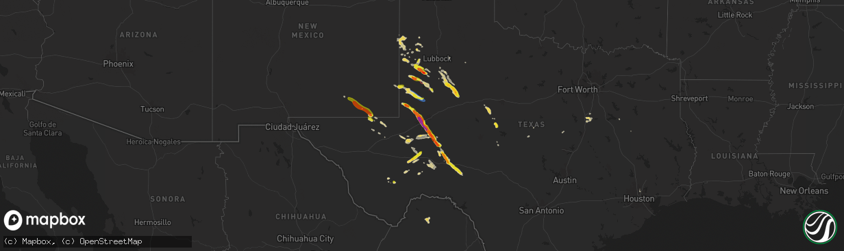
Hail Map on June 10, 2024
The weather event on June 10, 2024 includes Hail, Wind, and Tornado maps. 12 states and 300 cities were impacted and suffered possible damage. The total estimated number of properties impacted is 104,017.
Want more than just the map?
Turn this storm into a full workflow.
- Owner + property data so you know who to knock
- OnDemand branded weather history reports to win the "did we even have hail?" argument
- RoofTrace estimate so reps stop guessing numbers at the door
Bought this map? Upgrade within 7 days and we'll credit the $230. (10-15 min setup call)
Hail
Wind
Tornado
104,017
Estimated number of impacted properties by a 1.00" hail or larger68,089
Estimated number of impacted properties by a 1.75" hail or larger36,806
Estimated number of impacted properties by a 2.50" hail or largerStates Impacted by Hail Map on June 10, 2024
Storm reports
Wyoming
| Date | Description |
|---|---|
| 06/10/20245:52 PM CDT | A local report indicates 68 MPH wind near 7 NW Elk Mountain |
| 06/10/20245:42 PM CDT | Wind gusts measured between 4:42 and 4:46 pm |
| 06/10/20245:36 PM CDT | Wind gusts measured between 4:36 to 4:44 |
| 06/10/20243:35 PM CDT | Gusts estimated to be between 70-80 mph |
| 06/10/20243:26 PM CDT | Mesonet station kper green river 1.2 ne |
| 06/10/20243:06 PM CDT | A local report indicates 60 MPH wind near 2 NE Sundance |
| 06/10/20242:32 PM CDT | Mesonet station wy8 church butte. |
| 06/10/20241:55 PM CDT | A local report indicates 1.00 inch wind near Hulett |
Georgia
| Date | Description |
|---|---|
| 06/10/20245:15 PM CDT | Mesonet station uga53 vienna. |
| 06/10/20245:07 PM CDT | Public report of two trees down and minor damage to the awning of a home at the intersection of coody dairy rd and dooly high rd. |
| 06/10/20243:40 PM CDT | Tree downed across sr 165 at wpa rd. |
| 06/10/20243:30 PM CDT | Corrects previous tstm wnd dmg report from chauncey. Multiple photos of tree damage to the 100 block of railroad ave. In chauncey... Ga. A large uprooted tree fell on a |
| 06/10/20243:30 PM CDT | Corrects previous tstm wnd dmg report from chauncey. Photos of damage to the underside of a manufactured home near 126 bush st. In chauncey... Ga. Metal sheeting blown |
| 06/10/20243:25 PM CDT | Overturned center pivot irrigation system at the intersectio�����������������������������������������������������������������������������������������������������������������������������������������������������������������������������������������������������������������������������������������������������������������������������������������������������������������������������������������������������������������������������������������������������������������������������������������������������������������������������������������������������������������������������������������������������������������������������������������������������������������������������������������������������������������������������������������������������������������������������������������������������������������������������������������������������������������������������������������������������������������������������������������������������������������������������������������������������������������������������������������������������������������������������������������������������������������������������������������������������������������������������������������������������������������������������������������������������������������������������������������������������������������������������������������������������������������������������������������������������������������������������������������������������������������������������������������������������������������������������������������������������������������������������������������������������������������������������������������������������������������������������������������������������������������������������������������������������������������������������������������������������������������������������������������������������������������������������������������������������������������������������������������������������������������������������������������������������������������������������������������������������������������������������������������������������������������������������������������������������������������������������������������������������������������������������������������������������������������������������������������������������������������������������������������������������������������������������������������������������������������������������������������������������������������������������������������������������������������������������������������������������������������������������������������������������������������������������������������������������������������������������������������������������������������������. |
| 06/10/20243:25 PM CDT | Multiple trees down on property at residence on 600 block of marion sheffield rd. |
| 06/10/20243:25 PM CDT | Overturned center pivot irrigation system at the intersection of chauncey rhine hwy and marion sheffield rd. |
| 06/10/20243:25 PM CDT | Two trees down on vehicles at two separate residences on the 700 block of marion sheffield rd. |
| 06/10/20243:20 PM CDT | Multiple photos of tree damage to the 100 block of railroad ave. In chauncey... Ga. A large uprooted tree fell on a 2 car detached garage at 101 north railroad ave. |
| 06/10/20243:20 PM CDT | Photos of damage to the underside of a manufactured home near 126 bush st. In chauncey... Ga. Metal sheeting blown away. |
| 06/10/20243:15 PM CDT | Overturned center pivot irrigation system near the intersection of pete peterson and alvin hardin rd. |
| 06/10/20243:00 PM CDT | Tree downed along hwy 26 westbound at the intersection of chicken road. |
| 06/10/20242:55 PM CDT | Tv media reported golf ball size hail along hwy 301. |
| 06/10/20242:54 PM CDT | Firefighter relayed pictures of ping-pong sized hail. Time estimated via radar. |
| 06/10/20242:48 PM CDT | Co-op observer reports quarter-sized hail. |
| 06/10/20242:48 PM CDT | Firefighter relayed pictures of 2.0 inch hail along highway 196... Just outside of glennville. Time estimated via radar. |
| 06/10/20242:47 PM CDT | Trained spotter reported half dollar size hail along county road 322 at cecil anderson road. |
| 06/10/20242:42 PM CDT | Co-op observer relayed pictures of hail measuring 2.0 inches. Time estimated via radar. |
| 06/10/20242:42 PM CDT | Broadcast media relayed a picture on social media of tennis ball sized hail. Time estimated via radar. |
| 06/10/20242:36 PM CDT | Tree limbs reported down on ga 300 northbound near pike road. |
| 06/10/20242:30 PM CDT | Broadcast media relayed a picture via social media of hail measuring 2.0 inches. Time estimated via radar. |
| 06/10/20242:20 PM CDT | 1.25 inch hail reported in henderson at ga hwy 26 and us hwy 41. |
| 06/10/20242:00 PM CDT | Tree downed across ga hwy 300 southbound at lakeshore drive. |
| 06/09/20247:09 PM CDT | Plant vogtle control room employee noticed numerous limbs... Some small and some large along river road at the entrance to the plant. |
Colorado
| Date | Description |
|---|---|
| 06/10/20246:29 PM CDT | Report from mping: half dollar |
| 06/10/20246:27 PM CDT | A local report indicates 1.00 inch wind near Canon City |
| 06/10/20246:26 PM CDT | A local report indicates 1.25 inch wind near 1 S Canon City |
| 06/10/20246:04 PM CDT | A local report indicates 1.00 inch wind near 1 N Canon City |
South Carolina
| Date | Description |
|---|---|
| 06/10/20246:57 PM CDT | Large tree down in yard |
| 06/10/20246:55 PM CDT | *** 1 inj *** berkeley county em records indicated at least 28 homes damaged by falling trees. One female reported injured when a tree fell on her residence on college |
| 06/10/20246:55 PM CDT | *** 1 inj *** berkeley county em records indicated at least 28 homes damaged by falling trees. One female reported injured when a tree fell on her residence on college |
| 06/10/20246:54 PM CDT | Trees reported down along temple road. Time estimated from radar. |
| 06/10/20246:54 PM CDT | Tree reported down on powerlines at the corner of st james ave and myers rd. Time estimated from radar. |
| 06/10/20246:54 PM CDT | Trees down and house damage reported on penzance blvd. Time estimated via radar. |
| 06/10/20246:54 PM CDT | Tree reported down on powerlines at the corner of st james a |
| 06/10/20246:51 PM CDT | Nws storm survey team estimated peak wind gusts of 80 to 85 mph across the summerville and ladson areas. A swath of damaging winds measured 8.5 miles in length and 3.5 |
| 06/10/20246:51 PM CDT | Picture shared via social media of a large tree uprooted along foxtail pine road. Time estimated from radar. |
| 06/10/20246:51 PM CDT | Several trees down along i-26. |
| 06/10/20246:51 PM CDT | Picture relayed of a tree down on a car along halfacre lane. Time estimated from radar. |
| 06/10/20246:51 PM CDT | Emergency manager relayed pictures of damage to a fence as well as damage to house siding in the hunter's bend neighborhood. Time estimated from radar. |
| 06/10/20246:48 PM CDT | Individual reported 1.75 to 2.0 sized hail close to the intersection of hermitage lane and discovery drive. Some hail damage to house siding was also reported. Time est |
| 06/10/20246:48 PM CDT | Trained spotter reported multiple trees down and one tree on a house along pondarosa drive. |
| 06/10/20246:48 PM CDT | Trained spotter reported trees down and damage to house siding on lodgepole road. Time estimated via radar. |
| 06/10/20246:48 PM CDT | Schp reported a tree down on interstate 26... Around .75 miles from the college park road exit 203. |
| 06/10/20246:45 PM CDT | Spotter reported quarter size hail and gusty winds. |
| 06/10/20246:45 PM CDT | Numerous trees snapped off or blown down within four neighborhoods between old trolley rd and miles jamison rd. |
| 06/10/20246:45 PM CDT | Trees reported down along charlie lane. Time estimated from radar. |
| 06/10/20246:42 PM CDT | Individual reported golf ball sized hail along ladson road. Time estimated via radar. |
| 06/10/20246:40 PM CDT | Nws employee reported golf ball size hail. |
| 06/10/20246:38 PM CDT | Ping pong ball size hail near beech hill elementary. |
| 06/10/20246:36 PM CDT | Trees reported down along legend oaks way. Time estimated via radar. |
| 06/10/20246:35 PM CDT | Mping report of 2 inch hail. Time estimated from radar. Time estimated from radar. |
| 06/10/20246:35 PM CDT | Emergency manager reported hail close to golf ball size. Time estimated from radar. |
| 06/10/20246:16 PM CDT | Numerous trees down in 7300 block of parkers ferry rd. |
| 06/10/20246:15 PM CDT | Numerous large trees blown down or snapped off in the 6800 block of parkers ferry rd. |
| 06/10/20246:12 PM CDT | Emergency manager reported a tree down on capital road blocking both lanes. Time estimated via radar. |
| 06/10/20246:06 PM CDT | South carolina highway patrol reported a tree down on jacksonboro road. Time estimated via radar. |
| 06/10/20246:06 PM CDT | South carolina highway patrol reported powerlines down on highway 64 near the intersection with sparks drive. |
| 06/10/20246:06 PM CDT | South carolina highway patrol reported a tree down along green pond highway. Time estimated via radar. |
| 06/10/20246:06 PM CDT | Emergency manager reported a tree down in the 13000 block of charleston highway. Time estimated via radar. |
| 06/10/20246:06 PM CDT | South carolina highway patrol reported a tree down on parkers ferry road. Time estimated via radar. |
| 06/10/20246:06 PM CDT | Emergency manager reported a tree down in the 13000 block of charleston highway. Time estimated v |
| 06/10/20245:49 PM CDT | South carolina highway patrol reported powerlines down on near the intersection of white hall road and combahee road. |
| 06/10/20245:48 PM CDT | Emergency manager reported tree down in 3000 block of combahee road. Time estimated via radar. |
| 06/10/20245:22 PM CDT | Tree reported down in the 12000 block of north jacob smart blvd. Time estimated from radar. |
| 06/10/20245:03 PM CDT | Emergency manager reported a tree down in 12000 block of charleston highway. Time estimated via radar. |
| 06/09/20247:00 PM CDT | Numerous trees down in roadways and on homes and cars in the fairfax and oakbrook neighborhoods off hwy 176. |
Texas
| Date | Description |
|---|---|
| 06/10/20246:55 PM CDT | Awos station kgnc seminole. |
| 06/10/20246:03 PM CDT | Spotter reports dime to quarter size hail just ended. |
| 06/10/20246:02 PM CDT | Window broken in ballinger. |
| 06/10/20245:38 PM CDT | A local report indicates 59 MPH wind near 1 ENE Morton |
| 06/10/20245:56 AM CDT | Lids from tank batteries were blown off. Two tank batteries that were empty were displaced. One skidded about 200 yards from original location wh |
| 06/10/20245:56 AM CDT | Hitched trailer overturned on property. |
| 06/10/20245:56 AM CDT | Lids from tank batteries were blown off. Two tank batteries that were empty were displaced. One skidded about 200 yards from original location while the other blew near |
| 06/10/20245:56 AM CDT | 6 powerline poles snapped. Damage all laying in the same direction towards the south. |
| 06/10/20245:55 AM CDT | 10 powerline poles snapped with damage all laying in the same direction facing ese. Multiple poles snapped near the middle. Time estimated based on radar. |
| 06/09/20248:34 PM CDT | A local report indicates 1.75 inch wind near 3 ENE Odessa |
| 06/09/20248:27 PM CDT | A local report indicates 1.75 inch wind near 2 WSW Mission Dorado |
| 06/09/20248:26 PM CDT | Report from mping: quarter |
| 06/09/20248:25 PM CDT | A local report indicates 1.50 inch wind near 2 N Odessa |
| 06/09/20248:23 PM CDT | Report from mping: ping pong ball |
| 06/09/20248:23 PM CDT | Corrects previous tornado report from 4 nnw union. A video shared to broadcast media showed a brief tornado over an open field west of lamesa. The tornado did not cause |
| 06/09/20248:22 PM CDT | Slightly smaller than golf balls. |
| 06/09/20248:20 PM CDT | A local report indicates 2.25 inch wind near 1 SE Brownfield |
| 06/09/20248:18 PM CDT | Report of broken windows from hail and wind. |
| 06/09/20248:17 PM CDT | Report from mping: hen egg |
| 06/09/20247:45 PM CDT | Small business la michoacana paleteria y neveria had visible damage to the exterior wall and roofing. A submitted facebook photo of the damage was later confirmed by th |
| 06/09/20247:28 PM CDT | Multiple reports of a brief cone tornado from northeast of loop. Tornado crossed hwy 83 before dissipating. Tornado was over mainly open fields. |
| 06/09/20247:23 PM CDT | Video shows a brief rope tornado east of lamesa. This was over open fields. |
| 06/09/20247:22 PM CDT | Corrects previous tornado report from 2 e loop. Multiple observers reported a brief cone tornado to the northeast of loop. The tornado only lasted two to three minutes |
New Mexico
| Date | Description |
|---|---|
| 06/10/20244:54 PM CDT | Spotter measured ping pong ball size hail. Time estimated from radar. |
| 06/10/20244:50 PM CDT | Spotter shared photo of 1/2 inch to 1 inch hail covering the ground. Time estimated from radar. |
Alabama
| Date | Description |
|---|---|
| 06/10/20242:31 PM CDT | Tree down on county road 412. |
| 06/10/20242:31 PM CDT | Tree down on highway 189. |
| 06/10/20242:31 PM CDT | Tree down on county road 420. |
Nebraska
| Date | Description |
|---|---|
| 06/10/20245:02 PM CDT | Wind gust measured at kcdr asos. Spotters report a large number of tumbleweeds blowing in the area. |
| 06/10/20244:29 PM CDT | Estimated gust between 55-60 mph |
| 06/10/20244:05 PM CDT | Measured from montrose raws. Time estimated from radar |
South Dakota
| Date | Description |
|---|---|
| 06/10/20246:50 PM CDT | A local report indicates 60 MPH wind near 5 ESE Norris |
| 06/10/20246:40 PM CDT | A local report indicates 60 MPH wind near 5 NW Okaton |
| 06/10/20246:15 PM CDT | A local report indicates 65 MPH wind near 3 ENE Midland |
| 06/10/20246:11 PM CDT | A local report indicates 62 MPH wind near 7 E Wanblee |
| 06/10/20246:09 PM CDT | A local report indicates 74 MPH wind near 1 NE Midland |
| 06/10/20246:06 PM CDT | (unr |
| 06/10/20246:06 PM CDT | A local report indicates 59 MPH wind near 7 E Wanblee |
| 06/10/20245:51 PM CDT | A local report indicates 59 MPH wind near 3 E Philip |
| 06/10/20245:45 PM CDT | A local report indicates 58 MPH wind near 4 E Cactus Flat |
| 06/10/20245:30 PM CDT | A local report indicates 66 MPH wind near 4 E Cactus Flat |
| 06/10/20245:16 PM CDT | A local report indicates 66 MPH wind near 6 W Cottonwood |
| 06/10/20245:15 PM CDT | Estimated 60-70 mph winds |
| 06/10/20245:09 PM CDT | A local report indicates 60 MPH wind near 3 NNW Scenic |
| 06/10/20244:54 PM CDT | A local report indicates 64 MPH wind near 3 NNW Scenic |
| 06/10/20244:50 PM CDT | A local report indicates 68 MPH wind near 3 NW Wasta |
| 06/10/20244:41 PM CDT | A local report indicates 64 MPH wind near 1 NNE Faith |
| 06/10/20244:40 PM CDT | A local report indicates 60 MPH wind near 9 WSW Red Elm |
| 06/10/20244:40 PM CDT | A local report indicates 70 MPH wind near 3 NW Wasta |
| 06/10/20244:35 PM CDT | A local report indicates 58 MPH wind near 3 NW Wasta |
| 06/10/20244:16 PM CDT | A local report indicates 70 MPH wind near 3 SE Deerfield |
| 06/10/20244:15 PM CDT | A local report indicates 74 MPH wind near 6 WSW Opal |
| 06/10/20244:15 PM CDT | A local report indicates 74 MPH wind near 2 W Opal |
| 06/10/20244:14 PM CDT | A local report indicates 58 MPH wind near Rapid City Arpt |
| 06/10/20244:13 PM CDT | A local report indicates 59 MPH wind near 7 NNE Ellsworth AFB |
| 06/10/20244:12 PM CDT | Tstm wind gusts estimated 60 to 70 mph. |
| 06/10/20244:12 PM CDT | Tstm wind gusts estimated 60 to 70 mph. |
| 06/10/20243:45 PM CDT | Tstm wind gusts estimated 60 to 70 mph. |
| 06/10/20243:45 PM CDT | Tstm wind gusts estimated 60 to 70 mph. |
| 06/10/20243:35 PM CDT | Estimated 60-70 mph |
| 06/10/20243:35 PM CDT | Estimated 60-70 mph... Half inch of rain |
| 06/10/20242:40 PM CDT | A local report indicates 65 MPH wind near 10 W Reva |
| 06/10/20242:26 PM CDT | A local report indicates 66 MPH wind near 4 N Ludlow |
| 06/10/20242:10 PM CDT | A local report indicates 1.25 inch wind near 3 SSE Harding |
| 06/10/20242:10 PM CDT | A local report indicates 60 MPH wind near 3 SSE Harding |
Cities Impacted by Hail Map on June 10, 2024
- Aiken, SC
- Windsor, SC
- Springfield, SC
- Williston, SC
- Neeses, SC
- Salley, SC
- Norway, SC
- Orangeburg, SC
- Cameron, SC
- Elloree, SC
- Santee, SC
- Vance, SC
- Alzada, MT
- Hammond, MT
- Boyes, MT
- Broadus, MT
- Leesburg, GA
- Devils Tower, WY
- Milan, GA
- Rhine, GA
- Moorcroft, WY
- Uvalda, GA
- Lyons, GA
- Hulett, WY
- Oglethorpe, GA
- Ideal, GA
- Oakfield, GA
- Mount Vernon, GA
- Warwick, GA
- Buffalo, SD
- De Soto, GA
- Marshallville, GA
- Vidalia, GA
- Capitol, MT
- Bowman, SC
- Camp Crook, SD
- Sundance, WY
- Reidsville, GA
- Opp, AL
- Lance Creek, WY
- Andalusia, AL
- Montezuma, GA
- Cordele, GA
- Cobb, GA
- Elko, GA
- Elkhart, TX
- Elba, AL
- Kinston, AL
- Vienna, GA
- Alva, WY
- Glennville, GA
- Abbeville, GA
- Fitzgerald, GA
- Unadilla, GA
- Belle Fourche, SD
- Ludowici, GA
- Aladdin, WY
- Rochelle, GA
- Pitts, GA
- Ludlow, SD
- Reva, SD
- Ralph, SD
- Prairie City, SD
- Lodgepole, SD
- Pineview, GA
- Newell, SD
- Corsicana, TX
- Beulah, WY
- Hawkinsville, GA
- Eastman, GA
- Lusk, WY
- Midway, GA
- Hinesville, GA
- Smithville, GA
- Broxton, GA
- Wray, GA
- Mud Butte, SD
- Bison, SD
- Lemmon, SD
- Meadow, SD
- Lagrange, WY
- Chauncey, GA
- Riceboro, GA
- Eden, TX
- McRae Helena, GA
- Hawk Springs, WY
- Fleming, GA
- Richmond Hill, GA
- Newcastle, WY
- Edgemont, SD
- Cadwell, GA
- Sweetwater, TX
- Blackwell, TX
- Harrison, NE
- Mullin, TX
- Hill City, SD
- Lead, SD
- Midland City, AL
- Headland, AL
- Carlsbad, NM
- Townsend, GA
- Alamo, GA
- Nolan, TX
- West, TX
- Newville, AL
- Abbott, TX
- Columbia, AL
- Ashford, AL
- Webb, AL
- Tennessee Colony, TX
- Union Center, SD
- Faith, SD
- Milford, TX
- Rochelle, TX
- Muleshoe, TX
- Sudan, TX
- Hillsdale, WY
- Burns, WY
- Cheyenne, WY
- Tuscola, TX
- Athens, TX
- Carpenter, WY
- Crawford, NE
- Whitney, NE
- Chadron, NE
- Wingate, TX
- Rincon, GA
- Hillsboro, TX
- Penelope, TX
- Soperton, GA
- Adrian, GA
- Port Wentworth, GA
- Malone, TX
- Loving, NM
- Rapid City, SD
- Ellsworth Afb, SD
- Box Elder, SD
- Caputa, SD
- New Underwood, SD
- Owanka, SD
- Wasta, SD
- Wall, SD
- Hardeeville, SC
- Rogers, NM
- Bynum, TX
- Sapelo Island, GA
- Eaton, CO
- Osage, WY
- Grover, CO
- Brantley, AL
- Upton, WY
- Scenic, SD
- Hermosa, SD
- Quinn, SD
- Dupree, SD
- Circle, MT
- Maple, TX
- Pinehurst, GA
- Morton, TX
- Amherst, TX
- Ridgeland, SC
- Guyton, GA
- Seabrook, SC
- Marathon, TX
- Littlefield, TX
- Swainsboro, GA
- East Dublin, GA
- Byromville, GA
- Beaufort, SC
- Hay Springs, NE
- Philip, SD
- Interior, SD
- Kadoka, SD
- Eagle Butte, SD
- Lantry, SD
- Cherry Creek, SD
- Midland, SD
- Milesville, SD
- Winters, TX
- Gill, CO
- Greeley, CO
- Briggsdale, CO
- Canon City, CO
- Ballinger, TX
- Bushnell, NE
- Pecos, TX
- Salt Flat, TX
- Cotopaxi, CO
- Westcliffe, CO
- Hobbs, NM
- Seminole, TX
- Green Pond, SC
- Yemassee, SC
- Kimball, NE
- Titusville, FL
- Belvidere, SD
- Orchard, CO
- Zephyr, TX
- Saratoga, WY
- Hanna, WY
- Elk Mountain, WY
- Wanblee, SD
- Okaton, SD
- Long Valley, SD
- Fort Pierre, SD
- Denver City, TX
- Holly Hill, SC
- Blackville, SC
- Ridgeville, SC
- Adams Run, SC
- Ravenel, SC
- Kersey, CO
- Bamberg, SC
- Cope, SC
- Penrose, CO
- Glenwood, GA
- Round O, SC
- Jacksonboro, SC
- Summerville, SC
- Ladson, SC
- Cuthbert, GA
- Roggen, CO
- White River, SD
- Mentone, TX
- Whiteface, TX
- Brooklet, GA
- Jonesboro, TX
- Padroni, CO
- Wiggins, CO
- Mosca, CO
- Weldona, CO
- Charleston, SC
- Goose Creek, SC
- Moncks Corner, SC
- Andrews, TX
- North Charleston, SC
- Levelland, TX
- Sundown, TX
- Gatesville, TX
- Brownfield, TX
- Stoneham, CO
- Snyder, CO
- Girard, GA
- Waynesboro, GA
- Fort Stockton, TX
- Cordesville, SC
- Springfield, GA
- Torrington, WY
- Murdo, SD
- Draper, SD
- Norris, SD
- Wood, SD
- Jay Em, WY
- Mission, TX
- Seagraves, TX
- Meadow, TX
- Baxley, GA
- Goldsmith, TX
- Early Branch, SC
- Varnville, SC
- Odessa, TX
- Gardendale, TX
- Sturgis, SD
- Merino, CO
- Howes, SD
- Hillrose, CO
- Welch, TX
- Lamesa, TX
- Midland, TX
- Twin City, GA
- Fort Morgan, CO
- Akron, CO
- Tahoka, TX
- Midkiff, TX
- McCamey, TX
- Tillman, SC
- Pineland, SC
- Garnett, SC
- Monahans, TX
- Dryden, TX
- Grandfalls, TX
- Odum, GA
- Ozona, TX
- Big Lake, TX
- Jesup, GA
- Houston, TX
- Lucedale, MS
- Imperial, TX
- Crane, TX
- Ralls, TX
- Lorenzo, TX
- Wilson, TX
- Post, TX
- Odonnell, TX
- Gail, TX
- Iraan, TX
- Sheffield, TX
- Fluvanna, TX
- Ira, TX
- Coahoma, TX