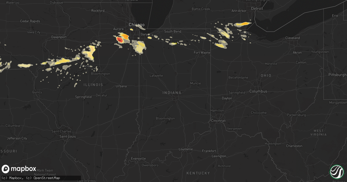
Hail Map in Indiana on June 10, 2015
Get this storm
June 10 map
$229
one time, instant access
Download today. No call, no setup
Keep the $229
Bought the map and want the full workflow? Apply the entire $229 to a subscription within 7 days. None of it is wasted.
Every map, not just this one
This buys you this map. Subscription and you get every map we run, in the markets you choose from a few cities to whole states to nationwide. Plus real-time alerts the moment a storm fires.
Contact data
Name, contact info, occupancy, even credit band for addresses in the footprint. You go from where it hit to who to call.
Become the source they trust
Unlimited branding weather history reports on demand. You already have the documented answer ready for the property owner, and you are the one who showed up with it.
Property data and RoofTrace estimates
Pull up any address you have got, its value and the exact code rules for that jurisdiction, straight from One Click Code. Then RoofTrace estimates the squares, pitch, and roof value, priced the way you price.
Storm reports in Indiana
Indiana
| Date | Description |
|---|---|
| 06/09/20158:50 PM CDT | Multiple trees and power lines down |
| 06/09/20158:44 PM CDT | Two center pivot irrigation systems blown over... One was mangled and possibly destroyed. Time estimated by radar. |
| 06/09/20158:25 PM CDT | Quarter size hail at us 30 and us 31 near plymouth |
| 06/09/20157:53 PM CDT | Tree down. |
All States Impacted by Hail Map on June 10, 2015
Cities Impacted by Hail Map on June 10, 2015
- Attalla, AL
- Newell, SD
- Romulus, NY
- Ovid, NY
- Penn Yan, NY
- Geneva, NY
- Karval, CO
- Hugo, CO
- Kit Carson, CO
- Eustis, NE
- Cozad, NE
- Farnam, NE
- Galesburg, IL
- Abingdon, IL
- Berwick, IL
- Monmouth, IL
- Cameron, IL
- Gilson, IL
- Maquon, IL
- Knoxville, IL
- Morton, MS
- Forest, MS
- Pulaski, MS
- Raleigh, MS
- Hennepin, IL
- McNabb, IL
- Lexington, NE
- Eddyville, NE
- Grant Park, IL
- Momence, IL
- Schneider, IN
- Lowell, IN
- Centerville, IA
- Cincinnati, IA
- Unionville, MO
- Livonia, MO
- Sherwood, OH
- Defiance, OH
- Jackson, MS
- Clinton, MS
- Raymond, MS
- Jonesville, LA
- Marksville, LA
- Harrison, NE
- Malta, ID
- Bellona, NY
- Beloit, KS
- Emelle, AL
- Scooba, MS
- Toulon, IL
- Wyoming, IL
- Gadsden, AL
- Georgetown, LA
- Elkton, FL
- Archer, NE
- Palmer, NE
- Aurora, NE
- Hampton, NE
- Marquette, NE
- Luverne, AL
- Ashland, NE
- Memphis, NE
- San Miguel, CA
- Villisca, IA
- Smithfield, IL
- Ipava, IL
- Cuba, IL
- Elmwood, IL
- Trivoli, IL
- Hamlet, IN
- Meridian, MS
- Carthage, MS
- Ethel, MS
- Kosciusko, MS
- Emerson, IA
- Red Oak, IA
- Gothenburg, NE
- Brimfield, IL
- Laura, IL
- Princeville, IL
- Gresham, NE
- Waco, NE
- Hobart, IN
- Valparaiso, IN
- Fairport, NY
- Pittsford, NY
- Victor, NY
- Rochester, NY
- Macedon, NY
- Henrietta, NY
- Saint Landry, LA
- Saint Augustine, FL
- East Palatka, FL
- Palatka, FL
- Hastings, FL
- Hicksville, OH
- Lodge Grass, MT
- Callaway, NE
- Kaycee, WY
- Brantley, AL
- Holstein, NE
- Wood River, NE
- Franklin, NE
- Kenesaw, NE
- Upland, NE
- Juniata, NE
- Campbell, NE
- Hastings, NE
- Minden, NE
- Heartwell, NE
- Doniphan, NE
- Alda, NE
- Ord, NE
- Yuma, CO
- Haxtun, CO
- Gillette, WY
- Douglas, WY
- Glenrock, WY
- Canton, IL
- North Platte, NE
- Hershey, NE
- Dickens, NE
- Sheridan, MO
- Bartow, GA
- Channahon, IL
- Minooka, IL
- Morris, IL
- Moravia, IA
- Cecil, OH
- Avilla, IN
- Woodworth, LA
- Washburn, IL
- Lacon, IL
- Sparland, IL
- Henry, IL
- Plainfield, IL
- Oswego, IL
- Kanab, UT
- Stapleton, NE
- Benkelman, NE
- Greensboro, AL
- New Lenox, IL
- Homer Glen, IL
- Mokena, IL
- Lockport, IL
- Joliet, IL
- Peoria, IL
- Bridgeview, IL
- Willow Springs, IL
- Hickory Hills, IL
- Justice, IL
- Oak Lawn, IL
- Burbank, IL
- Chicago Ridge, IL
- Litchfield, NE
- Weldon, IA
- Osceola, IA
- Agra, KS
- Kensington, KS
- Deweese, NE
- Nelson, NE
- Johnstown, NE
- Biggsville, IL
- York, AL
- Cuba, AL
- Elwood, NE
- Ferriday, LA
- Ransom, KS
- Utica, KS
- Wakeeney, KS
- Gasport, NY
- Max, NE
- Shorewood, IL
- Wilmington, IL
- Fort Smith, MT
- Lewistown, IL
- Minter, AL
- Morganza, LA
- Melville, LA
- Fordoche, LA
- Danvers, IL
- Kinston, AL
- Samson, AL
- Florala, AL
- Hayes Center, NE
- Shepherd, MT
- Huntley, MT
- Mercer, MO
- Cainsville, MO
- Princeton, MO
- Hineston, LA
- Pembroke Township, IL
- Lake Village, IN
- Naponee, NE
- Phillipsburg, KS
- Jena, LA
- Trout, LA
- Thomasville, AL
- Edon, OH
- Ayr, NE
- Lawrence, NE
- Glenvil, NE
- Blue Hill, NE
- Maywood, NE
- Wellfleet, NE
- Dry Creek, LA
- Mittie, LA
- Petersburg, MI
- Deerfield, MI
- Dundee, MI
- Palmyra, MI
- Ida, MI
- Temperance, MI
- La Salle, MI
- Blissfield, MI
- Ottawa Lake, MI
- Monroe, MI
- Riga, MI
- Gretna, NE
- Lecompte, LA
- Forest Hill, LA
- Liverpool, IL
- Central City, NE
- Chicago, IL
- Bloomington, NE
- Athol, KS
- Republican City, NE
- Riverton, NE
- Smith Center, KS
- Lamoni, IA
- Arapahoe, CO
- Burlington, IA
- Sidney, IA
- Thurman, IA
- Plattsmouth, NE
- Murray, NE
- Percival, IA
- Union, NE
- Tabor, IA
- Nehawka, NE
- Blockton, IA
- New Market, IA
- Bedford, IA
- Clarinda, IA
- Adrian, MI
- Clayton, MI
- Dannebrog, NE
- Webster, FL
- Dade City, FL
- Pineville, LA
- Deville, LA
- Gladstone, IL
- Purdum, NE
- Thedford, NE
- Beaver City, NE
- Wilsonville, NE
- Hendley, NE
- Norton, KS
- Corunna, IN
- Ashley, IN
- Waterloo, IN
- New Virginia, IA
- Tribune, KS
- Parnell, MO
- Beecher, IL
- Smithfield, NE
- Sumner, NE
- Willow Island, NE
- Overton, NE
- Arapahoe, NE
- Holbrook, NE
- Hopkins, MO
- Deridder, LA
- Saint Anne, IL
- Kilbourne, IL
- Easton, IL
- Tremont, IL
- Pekin, IL
- Chillicothe, IL
- Putnam, IL
- Granville, IL
- Tiskilwa, IL
- Princeton, IL
- Magnolia, IL
- Varna, IL
- Lowpoint, IL
- Bradford, IL
- Troy, AL
- Murray, IA
- Harrisville, MS
- Jupiter, FL
- Palm Beach Gardens, FL
- Shortsville, NY
- Palmyra, NY
- Farmington, NY
- Collinsville, MS
- Taft, CA
- Boaz, AL
- Glen Elder, KS
- Liberty, MS
- Jachin, AL
- Butler, AL
- Sweet Water, AL
- Ward, AL
- Linden, AL
- Pennington, AL
- Moreauville, LA
- Oglesby, IL
- Peru, IL
- Oconto, NE
- Newark, IL
- Rushville, IL
- Moulton, IA
- Udell, IA
- Mankato, KS
- Crest Hill, IL
- Monee, IL
- Manhattan, IL
- Elwood, IL
- Romeoville, IL
- Albion, IN
- Hudson, IN
- Anselmo, NE
- Brewster, NE
- Dunning, NE
- Arnold, NE
- Champion, NE
- Elba, NE
- Ashton, NE
- Farwell, NE
- Weskan, KS
- Rush, CO
- Mystic, IA
- Sharon Springs, KS
- Gravity, IA
- Nodaway, IA
- Wauseon, OH
- Fayette, OH
- Archbold, OH
- West Unity, OH
- Arlington, GA
- Saint Charles, IA
- Brandon, MS
- Portis, KS
- Gaylord, KS
- Montpelier, OH
- Edgerton, OH
- Bryan, OH
- Hamilton, IN
- Angola, IN
- Crown Point, IN
- Hebron, IN
- Cedar Lake, IN
- Crete, IL
- Morocco, IN
- Abbeville, AL
- Wallace, NE
- Garryowen, MT
- Crow Agency, MT
- Wyola, MT
- Lenox, IA
- Utica, NE
- Oberlin, KS
- Norcatur, KS
- Smithshire, IL
- Raritan, IL
- Media, IL
- Roseville, IL
- Sallis, MS
- Martin, OH
- Curtice, OH
- Edgar, NE
- Clay Center, NE
- Fairfield, NE
- Cuthbert, GA
- Brady, NE
- Choteau, MT
- Augusta, MT
- Leesburg, GA
- Alvordton, OH
- Waldron, MI
- Braxton, MS
- Mendenhall, MS
- Blythedale, MO
- Martinsville, MO
- Lineville, IA
- Leon, IA
- Denver, MO
- Eagleville, MO
- Hatfield, MO
- Grant City, MO
- Davis City, IA
- Ottawa, IL
- Prole, IA
- Indianola, IA
- Truro, IA
- Pemberville, OH
- Bowling Green, OH
- Perrysburg, OH
- Luckey, OH
- Camden, MI
- Lyons, OH
- Pittsford, MI
- Morenci, MI
- Liberty Center, OH
- Delta, OH
- Osseo, MI
- Hillsdale, MI
- Sand Creek, MI
- Napoleon, OH
- Hudson, MI
- Talladega, AL
- Mansura, LA
- Bonaparte, IA
- Keosauqua, IA
- Farmington, IA
- Donnellson, IA
- Milton, IA
- Cantril, IA
- Mount Sterling, IA
- Havana, IL
- Walnut Grove, MS
- Manito, IL
- Topeka, IL
- Maxwell, NE
- Moorefield, NE
- Curtis, NE
- Weeping Water, NE
- Jacksonville, FL
- Fernandina Beach, FL
- Louisville, MS
- Olney Springs, CO
- Orland Park, IL
- Frankfort, IL
- Hanna City, IL
- Mapleton, IL
- Greenville, AL
- Essex, IA
- Ville Platte, LA
- Glenmora, LA
- Saint Martinville, LA
- Galva, IL
- Kirkwood, IL
- Carman, IL
- Wallace, KS
- Sylacauga, AL
- Newport, MI
- Simmesport, LA
- Alpha, IL
- Woodhull, IL
- Guide Rock, NE
- Oakdale, LA
- Kinder, LA
- Oberlin, LA
- Clopton, AL
- Newville, AL
- Pella, IA
- Westville, IN
- Burwell, NE
- Effie, LA
- Boyce, LA
- La Harpe, IL
- Blandinsville, IL
- Dallas City, IL
- Sugartown, LA
- Grant, LA
- London Mills, IL
- Ellisville, IL
- Avon, IL
- Fairview, IL
- Williamsfield, IL
- Fort Pierce, FL
- Moorcroft, WY
- Deer Park, AL
- Speer, IL
- Etna Green, IN
- Pioneer, OH
- Aurora, NY
- Union Springs, NY
- Wesson, MS
- Washington, IL
- East Peoria, IL
- Pitkin, LA
- Diagonal, IA
- Shannon City, IA
- Creston, IA
- Afton, IA
- Clearfield, IA
- Buda, IL
- Neponset, IL
- Ramer, AL
- Loup City, NE
- Polk, NE
- Benedict, NE
- Hordville, NE
- Stromsburg, NE
- York, NE
- Bradshaw, NE
- Boelus, NE
- Livingston, AL
- Goodwater, AL
- Brooksville, FL
- Oregon, OH
- Toledo, OH
- Quitman, MS
- Saint Libory, NE
- Bourbon, IN
- Plymouth, IN
- Elsmere, NE
- Bunkie, LA
- Cheneyville, LA
- Orrville, AL
- Fellsmere, FL
- Macomb, IL
- Gordon, AL
- Pansey, AL
- Smithville, GA
- Bakersfield, CA
- Frazier Park, CA
- Roseland, NE
- Grand Island, NE
- Bladen, NE
- Arlington, IL
- La Salle, IL
- West Point, IA
- Union Mills, IN
- La Porte, IN
- Basco, IL
- Goshen, AL
- Sanford, FL
- Williston, OH
- Ligonier, IN
- Chapman, NE
- Mora, LA
- Genoa, OH
- Headland, AL
- Florence, MS
- Pearl, MS
- Pelahatchie, MS
- Swanton, OH
- Seaton, IL
- Bourbonnais, IL
- Kendallville, IN
- Wolcottville, IN
- Browning, MT
- Eureka, IL
- Bloomfield, IA
- Braceville, IL
- Braidwood, IL
- Coal City, IL
- Mazon, IL
- West Henrietta, NY
- Honeoye Falls, NY
- Plaquemine, LA
- Ravenwood, MO
- Ormond Beach, FL
- Saint Paul, NE
- Rockville, NE
- Nappanee, IN
- Lorman, MS
- Larwill, IN
- Mason City, IL
- Esbon, KS
- Tougaloo, MS
- Ridgeland, MS
- Flowood, MS
- Manteno, IL
- Peotone, IL
- Demotte, IN
- Shelby, IN
- Coin, IA
- Center Point, LA
- Oakford, IL
- Altoona, AL
- Metamora, IL
- Palos Hills, IL
- Augusta, IL
- Shelton, NE
- Youngsville, LA
- Abbeville, LA
- Drakesville, IA
- Jakin, GA
- Conehatta, MS
- Letohatchee, AL
- Lake, MS
- Reading, MI
- Enterprise, MS
- Toomsuba, MS
- Powersville, MO
- Randall, KS
- Seward, NE
- Lagrange, IN
- Topeka, IN
- Reeves, LA
- Ragley, LA
- Spring Valley, IL
- Seatonville, IL
- Depue, IL
- Lebanon, NE
- Congerville, IL
- Goodfield, IL
- Clearmont, MO
- Worth, MO
- Richland, MS
- Lomax, IL
- Stronghurst, IL
- Yates City, IL
- Dahinda, IL
- Chesterton, IN
- Cedar Point, IL
- Utica, IL
- Burr Oak, KS
- Albia, IA
- West Point, IL
- Gloster, MS
- Lauderdale, MS
- Ney, OH
- Evansport, OH
- New Bavaria, OH
- Stryker, OH
- Holgate, OH
- Mark Center, OH
- Table Grove, IL
- Elmer, LA
- King Ferry, NY
- Sylvania, OH
- Broussard, LA
- Leesburg, IN
- Warsaw, IN
- Seymour, IA
- Corydon, IA
- Tonica, IL
- Yorkville, IL
- Woodburn, IA
- Walkerton, IN
- Grovertown, IN
- Argos, IN
- Arcadia, NE
- Carthage, IL
- Alcolu, SC
- Coatsville, MO
- Exline, IA
- La Fayette, IL
- Gibsonburg, OH
- Helena, OH
- Edison, NE
- Cambridge, NE
- Edelstein, IL
- Dunlap, IL
- Edison, GA
- Morgan, GA
- Downs, KS
- Osceola, NE
- Marietta, IL
- Adair, IL
- Bushnell, IL
- Good Hope, IL
- Green Valley, IL
- Scottsville, NY
- Mendon, NY
- Churchville, NY
- Rush, NY
- Appleton, NY
- Burt, NY
- Barker, NY
- Batchelor, LA
- Lapine, AL
- Leighton, IA
- Secor, IL
- Carlock, IL
- Bloomington, IL
- Deer Creek, IL
- University Park, IA
- Oskaloosa, IA
- Shandon, CA
- Niota, IL
- Louisville, NE
- Plaucheville, LA
- Altona, IL
- Portage, IN
- Loxahatchee, FL
- Milford, NE
- Shellman, GA
- Lockport, NY
- Honoraville, AL
- Chunky, MS
- Hickory, MS
- Yoder, CO
- Natchez, MS
- Holland, OH
- Imlay, NV
- Edwards, MS
- Duson, LA
- Maurice, LA
- Pleasant Dale, NE
- North Liberty, IN
- Lakeville, IN
- Butler, IN
- Hildreth, NE
- Lake Powell, UT
- Millbury, OH
- Walbridge, OH
- Rossford, OH
- Maumee, OH
- Moravia, NY
- Scipio Center, NY
- Sharpsburg, IA
- Knoxville, IA
- Gibbon, NE
- Milford, IN
- Edwards, IL
- Chicago Heights, IL
- Dyer, IN
- Akron, AL
- Vermont, IL
- Denton, NE
- Lincoln, NE
- Leesville, LA
- Stanley, NY
- Wilcox, NE
- Wellington, FL
- Sciota, IL
- Roanoke, IL
- Grenville, NM
- Beaver Crossing, NE
- Grady, AL
- North Adams, MI
- Eufaula, AL
- Mark, IL
- Genoa, NY
- Mullen, NE
- Saint Marys, IA


