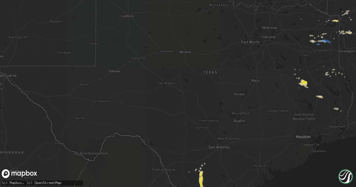
Hail Map in Texas on June 9, 2020
Get this storm
June 9 map
$229
one time, instant access
Download today. No call, no setup
Keep the $229
Bought the map and want the full workflow? Apply the entire $229 to a subscription within 7 days. None of it is wasted.
Every map, not just this one
This buys you this map. Subscription and you get every map we run, in the markets you choose from a few cities to whole states to nationwide. Plus real-time alerts the moment a storm fires.
Contact data
Name, contact info, occupancy, even credit band for addresses in the footprint. You go from where it hit to who to call.
Become the source they trust
Unlimited branding weather history reports on demand. You already have the documented answer ready for the property owner, and you are the one who showed up with it.
Property data and RoofTrace estimates
Pull up any address you have got, its value and the exact code rules for that jurisdiction, straight from One Click Code. Then RoofTrace estimates the squares, pitch, and roof value, priced the way you price.
Storm reports in Texas
Texas
| Date | Description |
|---|---|
| 06/09/20206:47 AM CDT | At 1147 PM CDT, a severe thunderstorm was located near Cotulla, moving south at 20 mph. HAZARD...60 mph wind gusts and quarter size hail. SOURCE...Radar indicated. IMPACT...Hail damage to vehicles is expected. Expect wind damage to roofs, siding, and trees. Locations impacted include... Cotulla, Gardendale and Artesia Wells. |
| 06/09/20206:10 AM CDT | At 1109 PM CDT, a severe thunderstorm was located near Kennard, or 16 miles northeast of Crockett, moving southeast at 20 mph. HAZARD...60 mph wind gusts and quarter size hail. SOURCE...Radar indicated. IMPACT...Hail damage to vehicles is expected. Expect wind damage to roofs, siding, and trees. Locations impacted include... Crockett, Lovelady, Kennard, Latexo, Pennington and Centralia. |
| 06/09/20205:57 AM CDT | At 1057 PM CDT, a severe thunderstorm was located near Millett, or 7 miles south of Dilley, moving south at 20 mph. HAZARD...60 mph wind gusts and quarter size hail. SOURCE...Radar indicated. IMPACT...Hail damage to vehicles is expected. Expect wind damage to roofs, siding, and trees. Locations impacted include... Cotulla, Millett, Los Angeles and Gardendale. |
| 06/09/20205:35 AM CDT | At 1034 PM CDT, a severe thunderstorm was located 7 miles east of Grapeland, or 14 miles north of Crockett, moving southeast at 15 mph. HAZARD...60 mph wind gusts and half dollar size hail. SOURCE...Radar indicated. IMPACT...Hail damage to vehicles is expected. Expect wind damage to roofs, siding, and trees. This severe thunderstorm will remain over mainly rural areas of north central Houston County. |
| 06/09/20204:12 AM CDT | At 912 PM CDT, a severe thunderstorm was located 8 miles north of Harleton, or 21 miles northwest of Marshall, moving east at 30 mph. HAZARD...60 mph wind gusts and quarter size hail. SOURCE...Radar indicated. IMPACT...Hail damage to vehicles is expected. Expect wind damage to roofs, siding, and trees. Locations impacted include... Jefferson, Smithland, Karnack, Berea, Harleton, Lodi, Woodlawn, Avinger, Uncertain, Lassater, Pruett and Leigh. |
| 06/09/20203:50 AM CDT | At 849 PM CDT, a severe thunderstorm was located over Wake Village, moving east at 25 mph. HAZARD...60 mph wind gusts and quarter size hail. SOURCE...Radar indicated. IMPACT...Hail damage to vehicles is expected. Expect wind damage to roofs, siding, and trees. Locations impacted include... Texarkana, Wake Village, Nash, Red Lick, Garland, Mandeville, Genoa, Leary, Hervey and Homan. |
| 06/09/20203:41 AM CDT | At 840 PM CDT, a severe thunderstorm was located over Maud, or 12 miles southeast of New Boston, moving east at 20 mph. HAZARD...60 mph wind gusts and quarter size hail. SOURCE...Radar indicated. IMPACT...Hail damage to vehicles is expected. Expect wind damage to roofs, siding, and trees. Locations impacted include... Texarkana, Redwater, Maud, Domino and Pleasant Hill. |
| 06/09/20203:31 AM CDT | At 831 PM CDT, a severe thunderstorm was located near Gilmer, moving east at 20 mph. HAZARD...60 mph wind gusts and quarter size hail. SOURCE...Radar indicated. IMPACT...Hail damage to vehicles is expected. Expect wind damage to roofs, siding, and trees. Locations impacted include... Gilmer, Ore City, Diana, Harleton, Cedar Springs, Midway, Lassater and Bettie. |
| 06/09/20203:24 AM CDT | At 824 PM CDT, a severe thunderstorm was located near Lone Star, or 11 miles east of Pittsburg, moving east at 25 mph. HAZARD...60 mph wind gusts and quarter size hail. SOURCE...Radar indicated. IMPACT...Hail damage to vehicles is expected. Expect wind damage to roofs, siding, and trees. Locations impacted include... Daingerfield, Hughes Springs, Lone Star, Jenkins, Avinger, Center Point and Holly Springs. |
| 06/08/202011:47 PM CDT | Asos station kcot cotulla. |
| 06/08/20209:22 PM CDT | Several trees downed in the pine harbor portion of lake o the pines. |
| 06/08/20209:02 PM CDT | Tree down off of fm 450 just south of lake o the pines. |
| 06/08/20209:00 PM CDT | Powerlines were downed north of queen city. |
| 06/08/20208:52 PM CDT | Tree down near fm 2148 and hwy 82 near nash. |
| 06/08/20208:52 PM CDT | Tree downed on fm 555 on the east side of gilmer. |
| 06/08/20208:37 PM CDT | Quarter size hail reported northeast of gilmer. Wind gust estimated near 60 mph also reported by storm spotter northeast of town. |
| 06/08/20208:34 PM CDT | Quarter size hail near jenkins just north of lone star. |
All States Impacted by Hail Map on June 9, 2020
Cities Impacted by Hail Map on June 9, 2020
- Plattsmouth, NE
- Murray, NE
- Hiawatha, KS
- Geneva, NE
- Fairmont, NE
- Rodessa, LA
- Bradley, AR
- Doddridge, AR
- McCool Junction, NE
- Gilmer, TX
- Cortland, NE
- Roca, NE
- Hickman, NE
- Firth, NE
- Adams, NE
- Bennet, NE
- Bradshaw, NE
- Marquette, NE
- Henderson, NE
- Hampton, NE
- Mission Hill, SD
- Utica, SD
- Irene, SD
- Searcy, AR
- Judsonia, AR
- Pangburn, AR
- Corrigan, TX
- Fairbury, NE
- Alexandria, NE
- Grand Rapids, MN
- Humboldt, NE
- Baileyville, KS
- Steinauer, NE
- Axtell, KS
- Burchard, NE
- Pawnee City, NE
- Auburn, NE
- Johnson, NE
- Table Rock, NE
- Encinal, TX
- Laredo, TX
- Clarks, NE
- Central City, NE
- Fullerton, NE
- Palmer, NE
- Grafton, NE
- Archer, NE
- Beaver Crossing, NE
- Friend, NE
- Milford, NE
- Magazine, AR
- Paris, AR
- Orlando, FL
- Frankfort, KS
- Ohiowa, NE
- Shickley, NE
- Strang, NE
- Bruning, NE
- Exeter, NE
- Chester, NE
- Belleville, KS
- Cotulla, TX
- Niobrara, NE
- Lynch, NE
- Brock, NE
- Talmage, NE
- Julian, NE
- Nebraska City, NE
- Bertrand, NE
- Oxford, NE
- Dwight, NE
- Brainard, NE
- Bee, NE
- Seward, NE
- Shubert, NE
- Rock Port, MO
- Falls City, NE
- Nemaha, NE
- Fairfax, MO
- De Witt, NE
- Pickrell, NE
- Clatonia, NE
- Branch, AR
- Plymouth, NE
- Ratcliff, AR
- North Bend, NE
- Morse Bluff, NE
- Rogers, NE
- Linwood, NE
- Hope, AR
- Texarkana, AR
- Washington, AR
- Fulton, AR
- Ogden, AR
- Endicott, NE
- Dilley, TX
- Wilber, NE
- Martell, NE
- Beatrice, NE
- Walton, NE
- Panama, NE
- Jefferson, TX
- Diana, TX
- Avinger, TX
- Ore City, TX
- Center, TX
- Wagner, SD
- Verdigre, NE
- Oneill, NE
- Reynolds, NE
- Hebron, NE
- Munden, KS
- Gilead, NE
- Daykin, NE
- Narka, KS
- Hubbell, NE
- Homer, LA
- Haynesville, LA
- Grapeland, TX
- Kennard, TX
- Crockett, TX
- Decatur, NE
- Lyons, NE
- Washington, KS
- Saint Edward, NE
- Plain Dealing, LA
- Rising City, NE
- Pacific Junction, IA
- Union, NE
- Assumption, IL
- Moweaqua, IL
- Charleston, AR
- Lavaca, AR
- Pittsburg, TX
- Leesburg, TX
- Big Wells, TX
- Remsen, IA
- Dodge, NE
- Tarkio, MO
- Chambers, NE
- Long Branch, TX
- Tenaha, TX
- Orchard, NE
- Royal, NE
- Erie, IL
- Albany, IL
- Fulton, IL
- Jonesboro, AR
- Elkhart, TX
- Conway, AR
- Port Barre, LA
- Dawson, NE
- Quitman, AR
- Cushing, TX
- Greenbrier, AR
- Page, NE
- Ewing, NE
- Scandia, KS
- Courtland, KS
- Norway, KS
- Centerville, SD
- Yankton, SD
- Hurley, SD
- Volin, SD
- Viborg, SD
- Texarkana, TX
- El Dorado, AR
- Schuyler, NE
- Onawa, IA
- Whiting, IA
- Garland, NE
- Blue Rapids, KS
- De Kalb, TX
- Simms, TX
- Waterloo, NE
- Le Mars, IA
- Converse, LA
- Westboro, MO
- New Boston, TX
- Newman Grove, NE
- Home, KS
- Kirbyville, TX
- Ida, LA
- Prague, NE
- Stella, NE
- Centralia, KS
- Vermillion, KS
- Elk Creek, NE
- Marcus, IA
- West Chester, IA
- Keota, IA
- Fred, TX
- Spurger, TX
- Westmoreland, KS
- Maitland, MO
- Craig, MO
- Forest City, MO
- Oregon, MO
- Mound City, MO
- Palestine, TX
- Dodson, LA
- Earle, AR
- Lewisville, AR
- Freeman, SD
- Goehner, NE
- Pattonville, TX
- Nash, TX
- Hooks, TX
- Maud, TX
- Pearsall, TX
- Shelbyville, TX
- Graham, MO
- Skidmore, MO
- Palmetto, LA
- Tecumseh, NE
- Brent, AL
- Williston, FL
- Lindsay, NE
- Weston, NE
- Malmo, NE
- Minden, LA
- Hallam, NE
- Crete, NE
- York, NE
- Hughes Springs, TX
- Palmyra, NE
- Benedict, NE
- Morrowville, KS
- Pickering, MO
- Maryville, MO
- Port Byron, IL
- Fenton, IL
- Cordova, IL
- Hillsdale, IL
- Logansport, LA
- Weeping Water, NE
- Olsburg, KS
- Dunlap, IA
- Lone Star, TX
- Olla, LA
- Jansen, NE
- Byron, NE
- Republic, KS
- Sprague, NE
- Diller, NE
- Swanton, NE
- Cuba, KS
- Odell, NE
- Lincoln, NE
- Wolbach, NE
- Haughton, LA
- Doyline, LA
- Elm Grove, LA
- Bossier City, LA
- Dardanelle, AR
- Daingerfield, TX
- Lovington, IL
- Winnfield, LA
- Verdon, NE
- Omaha, NE
- Atlanta, TX
- Garrison, TX
- Nacogdoches, TX
- Shenandoah, IA
- Clinton, IL
- Hopkins, MO
- Bradford, AR
- Pleasant Plains, AR
- Milligan, NE
- Aurora, NE
- Fort Calhoun, NE
- Davis, SD
- Worthing, SD
- Canton, SD
- Harrisburg, SD
- Lennox, SD
- Chancellor, SD
- Schoolcraft, MI
- Kalamazoo, MI
- Otsego, MI
- Plainwell, MI
- Portage, MI
- Vicksburg, MI
- Grant, MI
- Holton, MI
- Nunica, MI
- Ravenna, MI
- Muskegon, MI
- Conklin, MI
- Coopersville, MI
- Twin Lake, MI
- Grand Rapids, MI
- Whitehall, MI
- Fruitport, MI
- Marne, MI
- Round Lake, IL
- Mount Prospect, IL
- Schiller Park, IL
- River Forest, IL
- Melrose Park, IL
- Grayslake, IL
- Bensenville, IL
- Summit Argo, IL
- Palatine, IL
- Wauconda, IL
- Maywood, IL
- Barrington, IL
- Cicero, IL
- Bellwood, IL
- Forest Park, IL
- Riverside, IL
- Mchenry, IL
- Island Lake, IL
- Broadview, IL
- Elk Grove Village, IL
- Berwyn, IL
- Mundelein, IL
- Hines, IL
- Arlington Heights, IL
- Des Plaines, IL
- Brookfield, IL
- Oak Park, IL
- Rolling Meadows, IL
- Spring Grove, IL
- Chicago, IL
- Ringwood, IL
- Fox Lake, IL
- Stone Park, IL
- Burbank, IL
- Lake Zurich, IL
- La Grange, IL
- Ingleside, IL
- Lyons, IL
- Richmond, IL
- Franklin Park, IL
- Rockford, IL
- Monroe Center, IL
- Cherry Valley, IL
- Bourbonnais, IL
- Chebanse, IL
- Grant Park, IL
- Kankakee, IL
- Manteno, IL
- Beecher, IL
- Roberts, IL
- Manhattan, IL
- Hartley, IA
- Spencer, IA
- Everly, IA
- Mahaska, KS
- Du Bois, NE
- Seneca, KS
- Eagle, NE
- Alvo, NE
- Elmwood, NE
- Percival, IA
- Macedonia, IA
- Glenwood, IA
- Elliott, IA
- Henderson, IA
- Tabor, IA
- Hastings, IA
- Carson, IA
- Griswold, IA
- Red Oak, IA
- Malvern, IA
- Emerson, IA
- Silver City, IA
- Dunbar, NE
- Thurman, IA
- Sidney, IA
- Nehawka, NE
- Avoca, NE
- White Cloud, KS
- Beattie, KS
- Tipp City, OH
- Dayton, OH
- Sidney, OH
- Piqua, OH
- Troy, OH
- Vandalia, OH
- Fletcher, OH
- Casstown, OH


