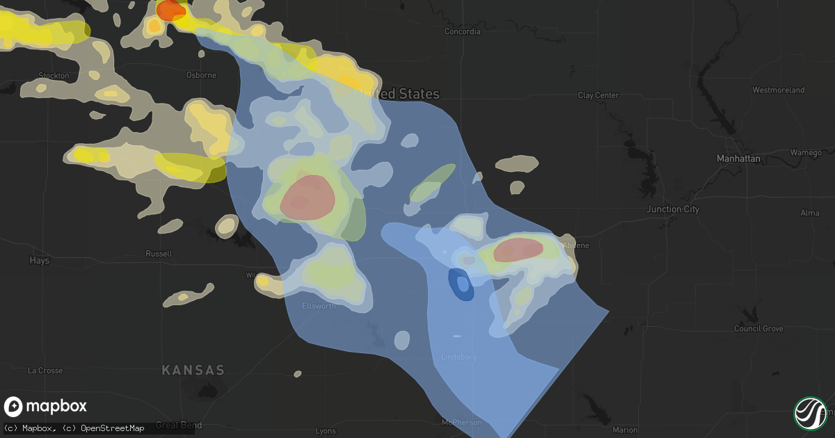
Hail Map in Tescott, KS on June 8, 2026
Get this storm
June 8 map
$229
one time, instant access
Download today. No call, no setup
Keep the $229
Bought the map and want the full workflow? Apply the entire $229 to a subscription within 7 days. None of it is wasted.
Every map, not just this one
This buys you this map. Subscription and you get every map we run, in the markets you choose from a few cities to whole states to nationwide. Plus real-time alerts the moment a storm fires.
Contact data
Name, contact info, occupancy, even credit band for addresses in the footprint. You go from where it hit to who to call.
Become the source they trust
Unlimited branding weather history reports on demand. You already have the documented answer ready for the property owner, and you are the one who showed up with it.
Property data and RoofTrace estimates
Pull up any address you have got, its value and the exact code rules for that jurisdiction, straight from One Click Code. Then RoofTrace estimates the squares, pitch, and roof value, priced the way you price.
Storm reports in Tescott, KS
Tescott, KS
| Date | Description |
|---|---|
| 06/07/20268:55 PM CDT | 100 foot by 80 foot steel barn destroyed via photos. Delayed report and time estimated by radar. |
| 06/07/20268:50 PM CDT | Large trees blown down. Estimated 80 mph winds. |
| 06/07/20268:50 PM CDT | Collapsed grain bin via photo. Time estimated report. |
| 06/07/20268:50 PM CDT | Delayed report - emergency manager reported several buildings missing roofs... 12 inch diameter trees down... And trees on houses. |
All States Impacted by Hail Map on June 8, 2026
All Cities Impacted by Hail Map on June 8, 2026
- Wallace, NE
- Arnold, NE
- North Platte, NE
- Madrid, NE
- Stapleton, NE
- Maxwell, NE
- Strang, OK
- Vinita, OK
- Spavinaw, OK
- Elsie, NE
- Grant, NE
- Colcord, OK
- Eucha, OK
- Jay, OK
- Rose, OK
- Kansas, OK
- Brady, NE
- Twin Oaks, OK
- Watts, OK
- Kismet, KS
- Tahlequah, OK
- Locust Grove, OK
- Oaks, OK
- Peggs, OK
- Gothenburg, NE
- Cozad, NE
- Hulbert, OK
- Lexington, NE
- Oconto, NE
- Callaway, NE
- Eddyville, NE
- Noel, MO
- Pineville, MO
- Sumner, NE
- Rocky Comfort, MO
- Miller, NE
- Exeter, MO
- Washburn, MO
- Pleasanton, NE
- Amherst, NE
- Mason City, NE
- Seligman, MO
- Wauneta, NE
- Sutherland, NE
- Hayes Center, NE
- Maywood, NE
- Curtis, NE
- Wheatland, WY
- Wilsonville, NE
- Eustis, NE
- Moorefield, NE
- Lebanon, NE
- Hendley, NE
- Wellfleet, NE
- Beaver City, NE
- Bartley, NE
- Arapahoe, NE
- Edison, NE
- Yoder, WY
- Holbrook, NE
- Oxford, NE
- Golden, CO
- Wheat Ridge, CO
- Arvada, CO
- Rush, CO
- Cambridge, NE
- Culbertson, NE
- Orleans, NE
- Stamford, NE
- Broomfield, CO
- Hugo, CO
- Sedalia, CO
- Matheson, CO
- Denver, CO
- Englewood, CO
- Castle Rock, CO
- Parker, CO
- Commerce City, CO
- Booker, TX
- Ramah, CO
- Evergreen, CO
- Alma, NE
- Westminster, CO
- Long Island, KS
- Franktown, CO
- Levelland, TX
- Portland, AR
- Keyes, OK
- Follett, TX
- Thornton, CO
- Elizabeth, CO
- Republican City, NE
- Phillipsburg, KS
- Naponee, NE
- Parkdale, AR
- Kress, TX
- Goodwell, OK
- Brighton, CO
- Fort Lupton, CO
- Aurora, CO
- Kiowa, CO
- Hudson, CO
- Bennett, CO
- Watkins, CO
- Pecos, TX
- Karval, CO
- Lenora, KS
- Wray, CO
- Idalia, CO
- Saint Francis, KS
- Kit Carson, CO
- Wild Horse, CO
- Strasburg, CO
- Alton, KS
- Gaylord, KS
- Logan, KS
- Stockton, KS
- Bogue, KS
- Chugwater, WY
- Silverton, TX
- Portis, KS
- Downs, KS
- Deer Trail, CO
- Agra, KS
- Bloomington, NE
- Weldona, CO
- Fort Morgan, CO
- Byers, CO
- Glade, KS
- Agate, CO
- Clarendon, TX
- Almena, KS
- Roggen, CO
- Wiggins, CO
- Perryton, TX
- Kirwin, KS
- Kensington, KS
- Bardwell, KY
- Cheyenne, WY
- Cedar, KS
- Canadian, TX
- Wickliffe, KY
- Lubbock, TX
- Arlington, KY
- Cunningham, KY
- Fancy Farm, KY
- Esbon, KS
- Snyder, CO
- Brush, CO
- Hillrose, CO
- Keenesburg, CO
- Bayard, NE
- Minatare, NE
- Woodrow, CO
- Shallowater, TX
- Limon, CO
- Akron, CO
- Veteran, WY
- Gering, NE
- Scottsbluff, NE
- Cawker City, KS
- Glen Elder, KS
- Osborne, KS
- Merino, CO
- Woodston, KS
- Plainville, KS
- Parks, NE
- Haigler, NE
- Genoa, CO
- Arriba, CO
- Natoma, KS
- Angora, NE
- Waldo, KS
- Sterling, CO
- Mankato, KS
- Lagrange, WY
- Tipton, KS
- Beloit, KS
- Hunter, KS
- Ropesville, TX
- Darrouzett, TX
- Simla, CO
- Paradise, KS
- Lebanon, KS
- Hawk Springs, WY
- Sylvan Grove, KS
- Lucas, KS
- Luray, KS
- Meadow, TX
- Otis, CO
- Flagler, CO
- Lyman, NE
- Barnard, KS
- Lincoln, KS
- Dorrance, KS
- New Cambria, KS
- Salina, KS
- Tescott, KS
- Hardesty, OK
- Iliff, CO
- Balko, OK
- Crook, CO
- Minneapolis, KS
- Torrington, WY
- Wilson, KS
- Ellsworth, KS
- Simpson, KS
- Bunker Hill, KS
- Chappell, NE
- Yuma, CO
- Russell, KS
- Hickory, KY
- Mayfield, KY
- Kuttawa, KY
- Symsonia, KY
- Farmington, KY
- Gilbertsville, KY
- Wingo, KY
- Princeton, KY
- Kirksey, KY
- Grand Rivers, KY
- Dexter, KY
- Murray, KY
- Benton, KY
- Eddyville, KY
- Sedalia, KY
- Almo, KY
- Calvert City, KY
- Hardin, KY
- Cadiz, KY
- New Concord, KY
- Glasco, KS
- Delphos, KS
- Lorraine, KS
- Beverly, KS
- Seibert, CO
- Joes, CO
- Carlos, MN
- Miltona, MN
- Eagle Bend, MN
- Bennington, KS
- Amherst, CO
- Eckley, CO
- Paoli, CO
- Julesburg, CO
- Sedgwick, CO
- Haxtun, CO
- Ovid, CO
- Holyoke, CO
- Fleming, CO
- Padroni, CO
- Atwood, CO
- Peetz, CO
- Big Springs, NE
- Lodgepole, NE
- Vona, CO
- Solomon, KS
- Kanopolis, KS
- Stratton, CO
- Dover, TN
- Herndon, KY
- Big Rock, TN
- Bumpus Mills, TN
- Abilene, KS
- Brookville, KS
- Geneseo, KS
- Marquette, KS
- Whiteface, TX
- Lindsborg, KS
- Falun, KS
- Bethune, CO
- Kirk, CO
- Champion, NE
- Benkelman, NE
- Venango, NE
- Imperial, NE
- Burlington, CO
- Assaria, KS
- Gypsum, KS
- Alliance, NE
- Longford, KS
- Galva, KS
- Mcpherson, KS
- Hope, KS
- Roxbury, KS
- Durham, KS
- Canton, KS
- Tampa, KS
- Enders, NE
- Lehigh, KS
- Ellsworth, NE
- Little River, KS
- Lyons, KS
- Ramona, KS
- Herington, KS
- Moundridge, KS
- Hillsboro, KS
- Burdick, KS
- Walton, KS
- Lincolnville, KS
- Goessel, KS
- Lost Springs, KS
- Hesston, KS
- North Newton, KS
- Marion, KS
- Newton, KS
- Peabody, KS
- Halstead, KS
- Palisade, NE
- Dickens, NE
- Kanorado, KS
- Wakefield, KS
- Bridgeport, NE
- Goodland, KS
- Chapman, KS
- Woodbine, KS
- Enterprise, KS
- Junction City, KS
- White City, KS
- Whitewater, KS
- Sedgwick, KS
- Valley Center, KS
- Florence, KS
- Wichita, KS
- Benton, KS
- Elbing, KS
- Hershey, NE
- Windom, KS
- Manhattan, KS
- Riley, KS
- Talmage, KS
- Miltonvale, KS
- Clay Center, KS
- Fort Riley, KS
- Milford, KS
- Dwight, KS
- Ogden, KS
- Saint George, KS
- Alta Vista, KS
- Alma, KS
- Wamego, KS
- Greenwich, KS
- Kechi, KS
- Potwin, KS
- Cedar Point, KS
- Burns, KS
- Elmdale, KS
- Council Grove, KS
- Cottonwood Falls, KS
- Wilsey, KS
- Strong City, KS
- Edson, KS
- Towanda, KS
- Rose Hill, KS
- Leon, KS
- Cassoday, KS
- Augusta, KS
- Matfield Green, KS
- Emporia, KS
- Derby, KS
- Douglass, KS
- Rosalia, KS
- El Dorado, KS
- Andover, KS
- Americus, KS
- Allen, KS
- McFarland, KS
- Eskridge, KS
- Paxico, KS
- Belvue, KS
- Maple Hill, KS
- Saint Marys, KS
- Admire, KS
- Reading, KS
- Eureka, KS
- Olpe, KS
- Brewster, KS
- Rossville, KS
- Topeka, KS
- Wakarusa, KS
- Burlingame, KS
- Auburn, KS
- Harveyville, KS
- Carbondale, KS
- Vernon, CO
- Scranton, KS
- Osage City, KS
- Neosho Rapids, KS
- Hartford, KS
- Hamilton, KS
- Madison, KS
- Beaumont, KS
- Latham, KS
- Piedmont, KS
- Silver Lake, KS
- Lebo, KS
- Levant, KS
- Lyndon, KS
- Berryton, KS
- Vassar, KS
- Quenemo, KS
- Waverly, KS
- Burlington, KS
- Melvern, KS
- Neosho Falls, KS
- Virgil, KS
- Severy, KS
- Toronto, KS
- Yates Center, KS
- Le Roy, KS
- Gridley, KS
- Neal, KS
- Delia, KS
- Tecumseh, KS
- Meriden, KS
- Overbrook, KS
- Grantville, KS
- Fall River, KS
- Piqua, KS
- Westphalia, KS
- Oskaloosa, KS
- Perry, KS
- Lecompton, KS
- Ozawkie, KS
- Pomona, KS
- Lawrence, KS
- Ottawa, KS
- McLouth, KS
- Tonganoxie, KS
- Williamsburg, KS
- Baldwin City, KS
- De Soto, KS
- Gardner, KS
- Eudora, KS
- Wellsville, KS
- Olathe, KS
- Basehor, KS
- Welda, KS
- Richmond, KS
- Bonner Springs, KS
- Rantoul, KS
- Edgerton, KS
- Linwood, KS
- Colony, KS
- Garnett, KS
- Kansas City, KS
- Princeton, KS
- Lenexa, KS
- Shawnee, KS
- Paola, KS
- Spring Hill, KS
- Centerville, KS
- La Cygne, KS
- Mound City, KS
- Lane, KS
- Blue Mound, KS
- Greeley, KS
- Fontana, KS
- Osawatomie, KS
- New Century, KS
- Parker, KS
- Kincaid, KS
- Ellis, KS
- Mission, KS
- Louisburg, KS
- Stilwell, KS
- Overland Park, KS
- Prairie Village, KS
- Bucyrus, KS
- Leawood, KS
- Belton, MO
- Kansas City, MO
- Cleveland, MO
- Drexel, MO
- Pleasanton, KS
- Grandview, MO
- Peculiar, MO
- Freeman, MO
- Amsterdam, MO
- Adrian, MO
- Butler, MO
- Archie, MO
- Lees Summit, MO
- Raymore, MO
- Greenwood, MO
- Pleasant Hill, MO
- Harrisonville, MO
- La Harpe, KS
- Iola, KS
- Humboldt, KS
- Hays, KS
- Erie, KS
- Savonburg, KS
- Elsmore, KS
- Moran, KS
- Victoria, KS
- Uniontown, KS
- Gorham, KS
- Strasburg, MO
- East Lynne, MO
- Holden, MO
- Warrensburg, MO
- Chilhowee, MO
- Garden City, MO
- Creighton, MO
- Lone Jack, MO
- Grain Valley, MO
- Clinton, MO
- Urich, MO
- Leeton, MO
- Kingsville, MO
- Blairstown, MO
- Centerview, MO
- Calhoun, MO
- Jewell, KS
- Randall, KS
- Windsor, MO
- Knob Noster, MO
- Jamestown, KS
- New Raymer, CO
- Concordia, KS
- Aurora, KS
- Osceola, MO
- Lowry City, MO
- Collins, MO
- Briggsdale, CO
- Leonardville, KS
- Stoneham, CO
- Detroit Lakes, MN
- Penokee, KS
- Grover, CO
- Olsburg, KS
- Westmoreland, KS
- Bronson, KS
- Sidney, NE
- Winger, MN
- Bejou, MN
- Fertile, MN
- Ponemah, MN
- Brookport, IL
- Golconda, IL
- Lone Tree, CO
- Boaz, KY
- Paducah, KY


