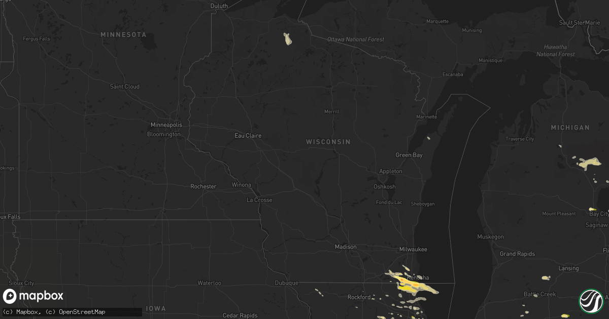
Hail Map in Wisconsin on June 8, 2015
Get this storm
June 8 map
$229
one time, instant access
Download today. No call, no setup
Keep the $229
Bought the map and want the full workflow? Apply the entire $229 to a subscription within 7 days. None of it is wasted.
Every map, not just this one
This buys you this map. Subscription and you get every map we run, in the markets you choose from a few cities to whole states to nationwide. Plus real-time alerts the moment a storm fires.
Contact data
Name, contact info, occupancy, even credit band for addresses in the footprint. You go from where it hit to who to call.
Become the source they trust
Unlimited branding weather history reports on demand. You already have the documented answer ready for the property owner, and you are the one who showed up with it.
Property data and RoofTrace estimates
Pull up any address you have got, its value and the exact code rules for that jurisdiction, straight from One Click Code. Then RoofTrace estimates the squares, pitch, and roof value, priced the way you price.
Storm reports in Wisconsin
Wisconsin
| Date | Description |
|---|---|
| 06/08/20153:58 PM CDT | Electrical line shorted out causing smoke/line to burn and drop from the pole. Small twigs/branches also down. Wind speed unknown. Delayed report. Time estimated. |
| 06/08/20153:30 PM CDT | Three 8 inch diameter trees and a few powerlines down on the north side of appleton. |
| 06/08/20151:53 PM CDT | Report from spring valley country club. Lots of hail with the largest ones the size of golf balls. |
| 06/08/20151:50 PM CDT | Time estimated based on radar. |
| 06/08/20151:50 PM CDT | A local report indicates 1.25 inch wind near 2 SSW PADDOCK LAKE |
| 06/08/20151:48 PM CDT | A local report indicates 1.00 inch wind near SILVER LAKE |
All States Impacted by Hail Map on June 8, 2015
Cities Impacted by Hail Map on June 8, 2015
- Brownsville, TN
- Munster, IN
- Dyer, IN
- Schererville, IN
- Chicago Heights, IL
- Matteson, IL
- Park Forest, IL
- Steger, IL
- McEwen, TN
- Hurricane Mills, TN
- Waverly, TN
- Burlington, WI
- Folsom, NM
- Grenville, NM
- Des Moines, NM
- Batavia, IL
- Geneva, IL
- Aurora, IL
- Warrenville, IL
- North Aurora, IL
- Buena Vista, TN
- Quincy, IL
- Avon, IN
- Plainfield, IN
- Danville, IN
- Goodland, IN
- Shippensburg, PA
- Newburg, PA
- Newville, PA
- Ursa, IL
- Fowler, IL
- Payson, IL
- Liberty, IL
- Lake Villa, IL
- Clarksville, TN
- South Holland, IL
- Lansing, IL
- Chicago, IL
- Rebuck, PA
- Herndon, PA
- Dornsife, PA
- Shamokin, PA
- Adolphus, KY
- Franklin, KY
- Westmoreland, TN
- Portland, TN
- Florence, AL
- Wilmot, WI
- Bristol, WI
- Salem, WI
- Antioch, IL
- Waukegan, IL
- Kenosha, WI
- Trevor, WI
- Zion, IL
- Wadsworth, IL
- Pleasant Prairie, WI
- Winthrop Harbor, IL
- Silver Lake, WI
- Fort Wayne, IN
- Sugar Grove, IL
- Big Rock, IL
- Rossville, IN
- Ohio, IL
- Big Sandy, TN
- Camden, TN
- Adair, IL
- Macomb, IL
- North Liberty, IN
- Bourbon, IN
- Lakeville, IN
- Walkerton, IN
- Bremen, IN
- Mill Creek, IN
- Rolling Prairie, IN
- La Porte, IN
- South Bend, IN
- Galien, MI
- New Carlisle, IN
- Plymouth, IN
- Deckerville, MI
- La Moille, IL
- Eads, TN
- Rossville, TN
- Ashville, AL
- Springville, AL
- Memphis, TN
- Harrisburg, PA
- Grantville, PA
- Dauphin, PA
- Hopkinsville, KY
- Heidelberg, MS
- Nesbit, MS
- Lake Cormorant, MS
- Pontotoc, MS
- Randolph, MS
- Kearneysville, WV
- Galveston, IN
- Walton, IN
- Warsaw, IL
- Mellen, WI
- Glidden, WI
- Okolona, MS
- Houlka, MS
- Houston, MS
- Shannon, MS
- Westminster, MD
- Littlestown, PA
- Taneytown, MD
- Spring Hill, TN
- Mount Joy, PA
- Elizabethtown, PA
- Hickory Valley, TN
- Covington, TN
- Blackstone, IL
- Streator, IL
- Vandalia, MO
- Middletown, MO
- Curryville, MO
- Perry, MO
- Center, MO
- McAlisterville, PA
- McClure, PA
- Kokomo, IN
- Elburn, IL
- Medaryville, IN
- San Pierre, IN
- North Judson, IN
- Keymar, MD
- Hanover, PA
- Cadiz, KY
- Elkton, KY
- Pembroke, KY
- Gracey, KY
- Trenton, KY
- Elgin, IL
- Sardis, TN
- Milledgeville, TN
- Mendon, MI
- Cedar Hill, TN
- Chapmansboro, TN
- Greenbrier, TN
- Springfield, TN
- Adams, TN
- Pleasant View, TN
- Ashland City, TN
- Noblesville, IN
- Barrington, IL
- Lake Zurich, IL
- Milford, IL
- Onarga, IL
- Watseka, IL
- Cissna Park, IL
- Crescent City, IL
- Gilman, IL
- Pinson, TN
- Jackson, TN
- Beech Bluff, TN
- Ashland, MS
- Blue Mountain, MS
- Ripley, MS
- Joppa, AL
- Marion, NC
- Nebo, NC
- Calvert City, KY
- Gilbertsville, KY
- Hickory Flat, MS
- Myrtle, MS
- Union Grove, WI
- Kansasville, WI
- Alexandria, MO
- Gunnison, MS
- Big Creek, MS
- Hillsdale, MI
- Jonesville, MI
- Delphi, IN
- Camden, IN
- Monticello, IN
- Cross Plains, TN
- Coldwater, MS
- Remington, IN
- Fayette, AL
- Bankston, AL
- Hernando, MS
- Herndon, KY
- Camby, IN
- Whiteland, IN
- Franklin, IN
- Greenwood, IN
- Mooresville, IN
- Bargersville, IN
- Lafayette, IN
- Cropsey, IL
- Colfax, IL
- Fairbury, IL
- Chenoa, IL
- Amboy, IL
- Sublette, IL
- Mendota, IL
- Henderson, TN
- Westville, IN
- Union Mills, IN
- Wanatah, IN
- Valparaiso, IN
- Collierville, TN
- Sheldon, IL
- Earl Park, IN
- Holly Springs, MS
- Lamar, MS
- Russellville, KY
- Schuylkill Haven, PA
- Bradford, TN
- Maple Park, IL
- Itta Bena, MS
- Hannibal, MO
- Keedysville, MD
- Shepherdstown, WV
- Sharpsburg, MD
- Cruger, MS
- Baileyton, AL
- Arab, AL
- Clayton, IN
- Prescott, MI
- Orrstown, PA
- Lurgan, PA
- Chambersburg, PA
- Jacks Creek, TN
- Enville, TN
- Mosquero, NM
- Brussels, WI
- Sturgeon Bay, WI
- Bowling Green, MO
- Bloomington, IL
- Congerville, IL
- Danvers, IL
- Carlock, IL
- Bath Springs, TN
- Decaturville, TN
- Senatobia, MS
- Dukedom, TN
- Pine Grove, PA
- Hamburg, PA
- Auburn, PA
- Twin Lakes, WI
- Richmond, IL
- Spring Grove, IL
- Francesville, IN
- Duncannon, PA
- Stanton, TN
- Sterling, MI
- La Crosse, IN
- Knox, IN
- Donovan, IL
- Kentland, IN
- Martinton, IL
- Iroquois, IL
- Oxford, MS
- Taylor, MS
- Batesville, MS
- Sidon, MS
- Conchas Dam, NM
- Trementina, NM
- Moriarty, NM
- Bolivar, TN
- Walnut, MS
- Tiplersville, MS
- Saulsbury, TN
- Whiteville, TN
- Middleton, TN
- Michigan City, MS
- Falkner, MS
- Somerville, TN
- Elkhart, IN
- Guntersville, AL
- Hardin, KY
- Dexter, KY
- Pope, MS
- Courtland, MS
- Boonsboro, MD
- Fishers, IN
- Hanna, IN
- Cumberland Furnace, TN
- Charlotte, TN
- White Pigeon, MI
- Union, MI
- Olmstead, KY
- Adairville, KY
- Silver Creek, MS
- Hobart, IN
- Lake Station, IN
- Gary, IN
- Merrillville, IN
- Crown Point, IN
- Portage, IN
- Saint Charles, IL
- Lisle, IL
- Naperville, IL
- Mooseheart, IL
- Lupton, MI
- Hale, MI
- Rose City, MI
- South Branch, MI
- West Branch, MI
- Kouts, IN
- Winamac, IN
- Deerfield, IL
- Lake Forest, IL
- Highwood, IL
- Vernon Hills, IL
- Lincolnshire, IL
- Libertyville, IL
- Highland Park, IL
- Buffalo Grove, IL
- Ten Mile, TN
- Battle Creek, MI
- Auburn, MI
- Kawkawlin, MI
- Chickamauga, GA
- Gurnee, IL
- Reagan, TN
- Angola, IN
- Somonauk, IL
- Vermontville, MI
- Nashville, MI
- Ottawa, IL
- Mchenry, IL
- Grayslake, IL
- Round Lake, IL
- Ingleside, IL
- Fox Lake, IL
- Calhoun Falls, SC
- Lake Bluff, IL
- North Chicago, IL
- Springfield, WI
- Lake Geneva, WI
- Great Lakes, IL
- Elkhorn, WI
- Genoa City, WI
- Clarksdale, MS
- Mayfield, KY
- Nara Visa, NM
- Woodburn, KY
- Auburn, KY
- Camden, AR
- Farmington, KY
- Benton, KY
- Murray, KY
- Kirksey, KY
- Wingo, KY
- Almo, KY
- New Concord, KY
- Sedalia, KY
- Hazel, KY
- Buchanan, TN
- Coffeeville, MS
- Calhoun City, MS
- Waterford, WI
- Griffith, IN
- Chesterton, IN
- Highland, IN
- Melrose Park, IL
- Elmhurst, IL
- Franklin Park, IL
- Hinckley, IL
- Montgomery, IL
- Dekalb, IL
- Franklin, TN
- Kahoka, MO
- Wayland, MO
- Mount Pleasant Mills, PA
- Port Trevorton, PA
- Bearden, AR
- Smyrna, TN
- Nolensville, TN
- Arrington, TN
- Markham, IL
- Harvey, IL
- Homewood, IL
- Posen, IL
- Hazel Crest, IL
- Demotte, IN
- Flat Rock, AL
- Higdon, AL
- Ider, AL
- Hull, IL
- Holladay, TN
- Shoemakersville, PA
- Anderson, IN
- Atlanta, IN
- Elwood, IN
- Frankton, IN
- Star City, AR
- Allensville, KY
- Fairgrove, MI
- Akron, MI
- Halifax, PA
- Annville, PA
- Rochester, IN
- Kewanna, IN
- Decatur, TN
- Philadelphia, TN
- Minooka, IL
- Shorewood, IL
- Joliet, IL
- Ladoga, IN
- Crawfordsville, IN
- New Ross, IN
- Gladstone, NM
- Clayton, NM
- Roberts, IL
- Chatsworth, IL
- Piper City, IL
- New Johnsonville, TN
- Ubly, MI
- Snover, MI
- Sandusky, MI
- Palms, MI
- Cass City, MI
- Sturgis, MI
- Nashville, TN
- Pegram, TN
- Earlville, IL
- Saltillo, TN
- Goodlettsville, TN
- Stevenson, AL
- Hebron, IN
- Wheatfield, IN
- Louisa, KY
- Fort Gay, WV
- Battle Ground, IN
- Bringhurst, IN
- Blaine, KY
- Martha, KY
- East Chicago, IN
- Whiting, IN
- Hammond, IN
- Scalf, KY
- Walker, KY
- Flat Lick, KY
- Grand Junction, TN
- Lookout Mountain, GA
- Trenton, GA
- Wildwood, GA
- Tower City, PA
- Muir, PA
- Wiconisco, PA
- Spring Glen, PA
- Gratz, PA
- Dalmatia, PA
- Hegins, PA
- Bethel, PA
- Tremont, PA
- Millersburg, PA
- Williamstown, PA
- Elizabethville, PA
- Lykens, PA
- Berrysburg, PA
- Shartlesville, PA
- Bernville, PA
- Wolcott, IN
- Omer, MI
- Shipshewana, IN
- Howe, IN
- Middlebury, IN
- Sutter, IL
- Kent, IL
- Stockton, IL
- Lena, IL
- Hinsdale, IL
- Unionville, MI
- High Bridge, WI
- Spring City, TN
- Marengo, IL
- Wagon Mound, NM
- Arlington, TN
- Indianapolis, IN
- Parsons, TN
- Centerville, TN
- Linden, TN
- Pendleton, IN
- Lapel, IN
- Mishawaka, IN
- Saint Patrick, MO
- Canton, MO
- Bridgeport, AL
- Lowell, IN
- Twelve Mile, IN
- Rensselaer, IN
- Carthage, MS
- Only, TN
- Lexington, MS
- Anchor, IL
- Sibley, IL
- Gibson City, IL
- Marvell, AR
- Reading, MI
- Montgomery, MI
- Athens, TN
- Plainville, IL
- Mendon, IL
- New Site, MS
- Grayling, MI
- Louisiana, MO
- Frankford, MO
- Eolia, MO
- New London, MO
- Lee, IL
- Steward, IL
- Fowler, IN
- Reynolds, IN
- Brook, IN
- La Grange, IL
- Western Springs, IL
- Normal, IL
- South Fulton, TN
- Martin, TN
- Dresden, TN
- Capulin, NM
- Astoria, IL
- Bath, IL
- Ipava, IL
- Lewistown, IL
- Havana, IL
- Lewistown, PA
- Hickory Hills, IL
- Palos Hills, IL
- Palos Park, IL
- Worth, IL
- Palos Heights, IL
- Dickson, TN
- Toone, TN
- McKenzie, TN
- Palatine, IL
- Hoffman Estates, IL
- Rolling Meadows, IL
- Pleasant Hall, PA
- Melvin, IL
- Buckley, IL
- Loda, IL
- Hoagland, IN
- Belzoni, MS
- Pilgrim, KY
- Shenandoah Junction, WV
- Burns, TN
- White Bluff, TN
- Peotone, IL
- Westfield, IN
- Whitestown, IN
- Zionsville, IN
- North Salem, IN
- Roachdale, IN
- Hamlet, IN
- Bells, TN
- Brentwood, TN
- Fairview, TN
- Bon Aqua, TN
- Turner, MI
- Au Gres, MI
- Brookhaven, MS
- Bogue Chitto, MS
- Oak Park, IL
- Elmwood Park, IL
- Indian Mound, TN
- Cumberland City, TN
- Whites Creek, TN
- Guthrie, KY
- Palmyra, TN
- Southside, TN
- Oak Grove, KY
- Joelton, TN
- Orlinda, TN
- Fort Campbell, KY
- Woodlawn, TN
- Cunningham, TN
- Vanleer, TN
- Flora, IN
- Yeoman, IN
- Brookston, IN
- Chalmers, IN
- Logansport, IN
- Southaven, MS
- Salem, SC
- South Pittsburg, TN
- Gallant, AL
- Oneonta, AL
- Tchula, MS
- Prospect Heights, IL
- Arlington Heights, IL
- Mount Prospect, IL
- Wheeling, IL
- Silex, MO
- Elsberry, MO
- Selinsgrove, PA
- Pitman, PA
- Klingerstown, PA
- Sunbury, PA
- Leck Kill, PA
- Argos, IN
- Tippecanoe, IN
- Greenwood, MS
- Tunica, MS
- Marianna, AR
- Horton, AL
- Boaz, AL
- Evarts, KY
- New Lenox, IL
- Peru, IN
- Carpentersville, IL
- Dundee, IL
- Goshen, IN
- Osceola, IN
- Tompkinsville, KY
- Burkesville, KY
- New Buffalo, MI
- Marseilles, IL
- Northbrook, IL
- Glenview, IL
- Bensenville, IL
- Three Rivers, MI
- Centreville, MI
- Kuttawa, KY
- Sycamore, IL
- Carthage, IL
- Potts Camp, MS
- Sheridan, IN
- Tipton, IN
- Dolton, IL
- Calumet City, IL
- Drummonds, TN
- Newellton, LA
- Kingsland, AR
- Forrest, IL
- Cicero, IN
- Waterford, MS
- Port Royal, PA
- Mifflintown, PA
- Mifflin, PA
- Nunnelly, TN
- Thompsons Station, TN
- Lyles, TN
- Primm Springs, TN
- Lexington, TN
- Gettysburg, PA
- Emmitsburg, MD
- Rocky Ridge, MD
- College Grove, TN
- Eagleville, TN
- Flanagan, IL
- Gridley, IL
- Charlotte, MI
- Bellevue, MI
- Jamestown, IN
- New Market, IN
- Leland, IL
- Waterman, IL
- Sandwich, IL
- Coila, MS
- Wauconda, IL
- Island Lake, IL
- Mercer, TN
- Denmark, TN
- Princeton, KY
- Lovely, KY
- Belfry, KY
- Williamson, WV
- Fair Oaks, IN
- Finger, TN
- Lewisburg, KY
- Genoa, WV
- Snow Lake, AR
- Savannah, TN
- Poplar Grove, AR
- Montrose, IA
- Donnellson, IA
- Argyle, IA
- Kinderhook, IL
- New Canton, IL
- Holly Grove, AR
- Elaine, AR
- Kingston Springs, TN
- Cedar Lake, IN
- Saint John, IN
- Pontiac, IL
- Bumpus Mills, TN
- Minden City, MI
- Ashkum, IL
- Carsonville, MI
- Gagetown, MI
- Owendale, MI
- Sebewaing, MI
- Hollow Rock, TN
- Mansfield, TN
- Bruceton, TN
- Horn Lake, MS
- Monticello, AR
- Scottsville, KY
- Bowling Green, KY
- Alvaton, KY
- Algonquin, IL
- Sturtevant, WI
- Pearl City, IL
- Morris Chapel, TN
- Clinton, KY
- Ethel, AR
- Saint Charles, AR
- Sitka, KY
- Stambaugh, KY
- Flatgap, KY
- Eva, TN
- Wisconsin Rapids, WI
- Nekoosa, WI
- Watson, AR
- Tuscumbia, AL
- Bee Branch, AR
- Damascus, AR
- Big Rock, TN
- Winnetka, IL
- Des Plaines, IL
- Wilmette, IL
- Murfreesboro, TN
- Young America, IN
- Burnettsville, IN
- Idaville, IN
- Bartlett, IL
- Hanover Park, IL
- Denver, IN
- Royal Center, IN
- Moscow, TN
- Roy, NM
- Mercersburg, PA
- Woodstock, IL
- Garden Prairie, IL
- Belvidere, IL
- Dundee, MS
- Pioneer, TN
- Huntsville, TN
- Bunker Hill, IN
- Frankfort, IL
- Tinley Park, IL
- Monterey, IN
- Fordyce, AR
- Scottsboro, AL
- Troy, MO
- Ivan, AR
- Niles, IL
- Park Ridge, IL
- Helena, AR
- West Helena, AR
- Lexa, AR
- Dyer, TN
- Carlisle, PA
- Enola, PA
- Marysville, PA
- Mechanicsburg, PA
- Grovertown, IN
- Clifton, TN
- Oakland, MS
- Tillatoba, MS
- Enid, MS
- Trenton, TN
- Caledonia, IL
- Las Vegas, NM
- Stillman Valley, IL
- Water Valley, KY
- Gadsden, AL
- Herscher, IL
- Ledbetter, KY
- Brookport, IL
- Smithland, KY
- Grand Rivers, KY
- Eddyville, KY
- Bay City, MI
- Thawville, IL
- Upperstrasburg, PA
- Spring Run, PA
- Roxbury, PA
- Rosedale, MS
- Richton Park, IL
- Olympia Fields, IL
- Ramer, TN
- Guys, TN
- Olive Branch, MS
- Bethel Springs, TN
- Orland Park, IL
- Antioch, TN
- Newark, IL
- Shirley, AR
- Higden, AR
- Hohenwald, TN
- Lobelville, TN
- Kingston, TN
- Monticello, MS
- Newport, PA
- New Bloomfield, PA
- New Haven, IN
- Huntingdon, TN
- Niles, MI
- Princeton, IL
- Hampshire, TN
- Duck River, TN
- Randolph, UT
- Alligator, MS
- Vicksburg, MI
- Fairhope, AL
- Saint Helen, MI
- Grenada, MS
- Cascilla, MS
- Sardis, MS
- Water Valley, MS
- Oswego, IL
- Plainfield, IL
- Pleasant Hill, IL
- Rockport, IL
- Goodfield, IL
- Skokie, IL
- Lincolnwood, IL
- Michigan City, IN
- Coatesville, IN
- Cornell, IL
- Altoona, AL
- Adamsville, TN
- Scotts Hill, TN
- Huron, TN
- Millerstown, PA
- Mohrsville, PA
- Sacramento, PA
- Thompsontown, PA
- Liverpool, PA
- Tiline, KY
- Burna, KY
- Harmon, IL
- Adams, KY
- McDonald, TN
- Boiling Springs, PA
- Downers Grove, IL
- Woodridge, IL
- Lemont, IL
- Darien, IL
- Bolingbrook, IL
- Munford, TN
- Millington, TN
- Cordova, TN
- Atoka, TN
- North Adams, MI
- Ashland, PA
- Alburtis, PA
- Breinigsville, PA
- Fleetwood, PA
- Kutztown, PA
- Orwigsburg, PA
- Port Clinton, PA
- Mertztown, PA
- Topton, PA
- Macungie, PA
- Lyon Station, PA
- Lenhartsville, PA
- Emmaus, PA
- Cerulean, KY


