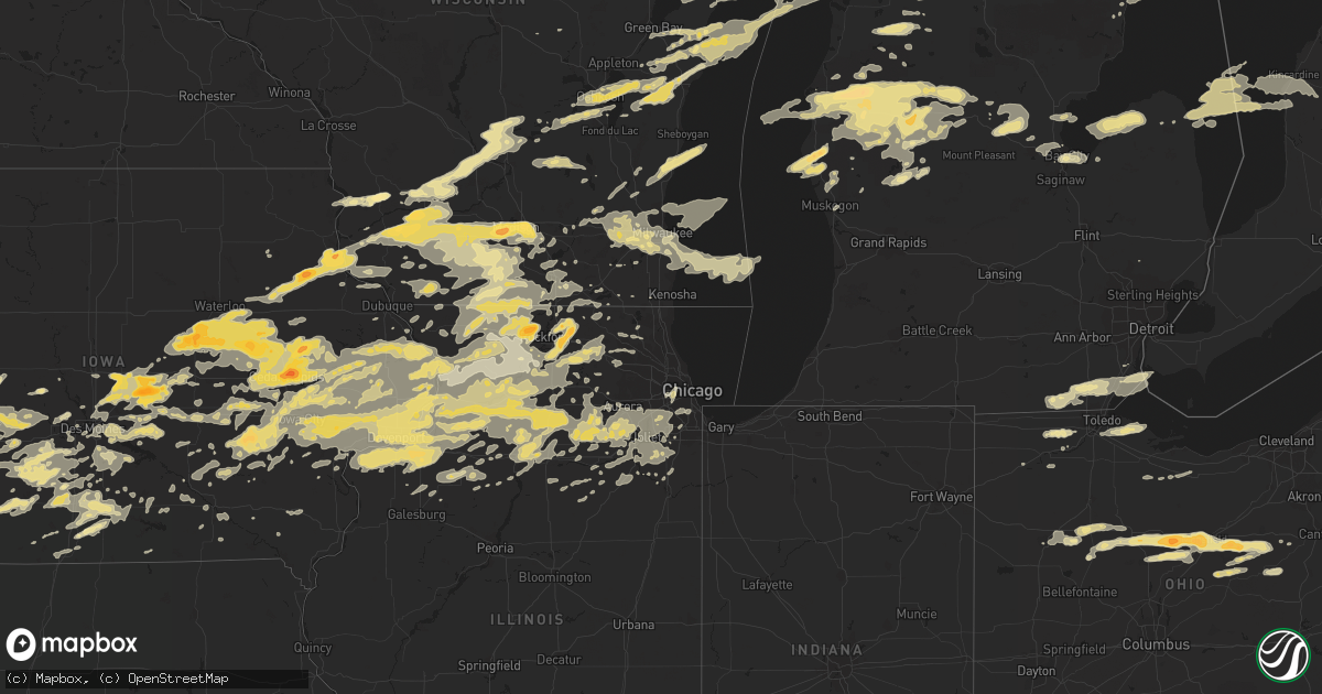
Hail Map in Illinois on June 8, 2011
Get this storm
June 8 map
$229
one time, instant access
Download today. No call, no setup
Keep the $229
Bought the map and want the full workflow? Apply the entire $229 to a subscription within 7 days. None of it is wasted.
Every map, not just this one
This buys you this map. Subscription and you get every map we run, in the markets you choose from a few cities to whole states to nationwide. Plus real-time alerts the moment a storm fires.
Contact data
Name, contact info, occupancy, even credit band for addresses in the footprint. You go from where it hit to who to call.
Become the source they trust
Unlimited branding weather history reports on demand. You already have the documented answer ready for the property owner, and you are the one who showed up with it.
Property data and RoofTrace estimates
Pull up any address you have got, its value and the exact code rules for that jurisdiction, straight from One Click Code. Then RoofTrace estimates the squares, pitch, and roof value, priced the way you price.
Storm reports in Illinois
Illinois
| Date | Description |
|---|---|
| 06/08/20116:00 AM CDT | 7 to 8 inch diameter trees down. Time estimated based on radar data. |
| 06/08/20115:54 AM CDT | Quarter to half dollar size hail. |
| 06/08/20115:34 AM CDT | A local report indicates 60 MPH wind near 6 NE EAST MOLINE |
| 06/08/20115:26 AM CDT | Huge tree branches down. |
| 06/08/20115:26 AM CDT | A local report indicates 75 MPH wind near MOLINE |
| 06/08/20115:25 AM CDT | Measured at the quad city international airport. |
| 06/08/20115:25 AM CDT | Measured at the quad city international airport. |
| 06/08/20115:20 AM CDT | Wind gusts estimated to be 60 to 70 mph near the rock island arsenal bridge in moline. |
| 06/08/20113:10 AM CDT | A local report indicates 67 MPH wind near BURNHAM |
| 06/08/20113:00 AM CDT | 5 inch dia tree fell on home with smaller branches down elswhere. 117th st and ridgeland. |
| 06/08/20113:00 AM CDT | Sustained winds 48-50 mph with peak gust to 58 mph. Pea sized hail. 91st and clifton park. |
| 06/08/20112:24 AM CDT | A local report indicates 1.00 inch wind near 1 N TAMPICO |
| 06/08/201112:10 AM CDT | Tree down near us52 and lisbon rd. |
| 06/07/201111:53 PM CDT | Large trees down - il47 and baseline rd. |
| 06/07/201111:50 PM CDT | Telephone pole snapped. Near fox river dr. |
| 06/07/201110:51 PM CDT | 10 inch dia tree down. Wilson waterview. Possible lightning damage. |
| 06/07/201110:50 PM CDT | 6 in dia tree snapped. Alpine rd and harrison. |
| 06/07/201110:42 PM CDT | 6 in dia tree snapped. 7800 block of hildred rd. |
| 06/07/201110:33 PM CDT | Tree limb on car. Time estimated based on radar. |
| 06/07/201110:29 PM CDT | A local report indicates 1.00 inch wind near POLO |
| 06/07/201110:22 PM CDT | South of belvidere - marble to golf ball sized hail. Via broadcast media. |
| 06/07/201110:22 PM CDT | Estimated hail from marble to golfball in size. Spotter was south of belvidere. Winds estimated to 45 mph. |
| 06/07/201110:16 PM CDT | Power lines and trees down. Report relayed from ogle county sheriff. Time estimated from radar. |
| 06/07/201110:12 PM CDT | 3/4 to 1 inch hail. |
| 06/07/201110:11 PM CDT | A local report indicates 60 MPH wind near ROCKFORD AIRPORT |
| 06/07/201110:10 PM CDT | A local report indicates 60 MPH wind near POPLAR GROVE |
| 06/07/201110:04 PM CDT | Trees and power lines down. |
| 06/07/201110:03 PM CDT | At wrex-tv studios. |
| 06/07/20119:54 PM CDT | Power lines down on hwy 75 near town...relayed by media |
| 06/07/20119:53 PM CDT | 15 ft long- 3in dia branch down. |
| 06/07/20119:32 PM CDT | A local report indicates 60 MPH wind near LENA |
| 06/07/20119:32 PM CDT | Lots of small tree branches and some larger branches down around town...time estimated from radar. |
| 06/07/20119:32 PM CDT | A local report indicates 1.00 inch wind near ORANGEVILLE |
| 06/07/20119:31 PM CDT | A local report indicates 62 MPH wind near 5 NW LENA |
| 06/07/20119:27 PM CDT | Numerous treesdown |
| 06/07/20119:25 PM CDT | Large maple tree down with furniture blown around in the yard of house. |
| 06/07/20119:24 PM CDT | Route 12 and winnebago road just west of intersection 20 to 30 year old tree snapped. Trunk diameter estimated at 1 foot. |
| 06/07/20118:37 PM CDT | Small limbs and leaves down |
| 06/07/20118:37 PM CDT | 5 inch branch down. |
All States Impacted by Hail Map on June 8, 2011
Cities Impacted by Hail Map on June 8, 2011
- Carbondale, IL
- Freeport, KS
- Bluff City, KS
- Caldwell, KS
- Franklin, WI
- Greendale, WI
- Hales Corners, WI
- Milwaukee, WI
- Casper, WY
- Glenrock, WY
- Midwest, WY
- South Amana, IA
- Williamsburg, IA
- Marengo, IA
- Victor, IA
- Ladora, IA
- Cunningham, KS
- Turon, KS
- Arlington, KS
- Loveland, CO
- Middleburgh, NY
- Schoharie, NY
- Berne, NY
- Pecatonica, IL
- Medicine Lodge, KS
- Malcom, IA
- Oneonta, NY
- East Meredith, NY
- Treadwell, NY
- Franklin, NY
- Delhi, NY
- Cornwall Bridge, CT
- Amenia, NY
- South Kent, CT
- Kent, CT
- Sharon, CT
- Wassaic, NY
- Porterville, MS
- Mohawk, NY
- Frankfort, NY
- Utica, NY
- Herkimer, NY
- Ilion, NY
- New Hartford, NY
- Hart, MI
- Rothbury, MI
- Montague, MI
- New Era, MI
- Shelby, MI
- Stoughton, WI
- Deerfield, WI
- Cambridge, WI
- Wheatland, WY
- Yoder, WY
- Veteran, WY
- Torrington, WY
- Avalon, WI
- Janesville, WI
- Nevada, IA
- Colo, IA
- Collins, IA
- Maxwell, IA
- Pierce, CO
- Ault, CO
- Stanton, IA
- Villisca, IA
- Red Oak, IA
- Essex, IA
- Wiggins, CO
- Ira, TX
- Coahoma, TX
- Elkport, IA
- Edgewood, IA
- Elkader, IA
- Strawberry Point, IA
- Williamsburg, MI
- Elk Rapids, MI
- Esmond, IL
- Garden Prairie, IL
- Lindenwood, IL
- Union, IL
- Genoa, IL
- Monroe Center, IL
- Kirkland, IL
- Kingston, IL
- Marengo, IL
- Hampshire, IL
- Huntley, IL
- Green Bay, WI
- Luxemburg, WI
- Kewaunee, WI
- Purling, NY
- Esperance, NY
- Troy, NY
- Richmondville, NY
- East Nassau, NY
- West Cornwall, CT
- Pittsfield, MA
- Red Hook, NY
- South Egremont, MA
- Malden Bridge, NY
- Southfield, MA
- Climax, NY
- Brainard, NY
- Cairo, NY
- Surprise, NY
- Hollowville, NY
- Becket, MA
- Rensselaer, NY
- Chichester, NY
- Stuyvesant Falls, NY
- Germantown, NY
- Kingston, NY
- Coeymans, NY
- Greenville, NY
- Lake Hill, NY
- Hensonville, NY
- Millerton, NY
- Wynantskill, NY
- Claverack, NY
- Fultonville, NY
- Stanfordville, NY
- West Fulton, NY
- Averill Park, NY
- Freehold, NY
- Hinsdale, MA
- Goshen, CT
- Voorheesville, NY
- Cornwall, CT
- Copake Falls, NY
- Guilderland, NY
- East Greenbush, NY
- Gilboa, NY
- Lee, MA
- Monterey, MA
- Johnstown, NY
- Acra, NY
- Craryville, NY
- West Camp, NY
- Great Barrington, MA
- New Preston Marble Dale, CT
- Cornwallville, NY
- Malden On Hudson, NY
- Wingdale, NY
- Oak Hill, NY
- East Canaan, CT
- Valatie, NY
- East Berne, NY
- Woodstock, NY
- Austerlitz, NY
- Latham, NY
- Falls Village, CT
- Cobleskill, NY
- North Blenheim, NY
- Bearsville, NY
- Philmont, NY
- Medusa, NY
- New Lebanon, NY
- West Coxsackie, NY
- Canaan, CT
- Summit, NY
- Lake Katrine, NY
- Hunter, NY
- Tivoli, NY
- Spencertown, NY
- Salisbury, CT
- East Chatham, NY
- Pine Plains, NY
- Delanson, NY
- Nassau, NY
- Elka Park, NY
- Fonda, NY
- Stuyvesant, NY
- Copake, NY
- New Baltimore, NY
- Canaan, NY
- Ancram, NY
- Stottville, NY
- West Stockbridge, MA
- Sand Lake, NY
- Selkirk, NY
- Otis, MA
- Dalton, MA
- Watervliet, NY
- Coeymans Hollow, NY
- South Bethlehem, NY
- Tannersville, NY
- Tyringham, MA
- Norfolk, CT
- Slingerlands, NY
- Durham, NY
- Sheffield, MA
- Willow, NY
- Glenmont, NY
- Staatsburg, NY
- South Cairo, NY
- Duanesburg, NY
- Haines Falls, NY
- Chatham, NY
- Palenville, NY
- Athens, NY
- Round Top, NY
- Richmond, MA
- Poestenkill, NY
- Kinderhook, NY
- Millbrook, NY
- Warnerville, NY
- Clinton Corners, NY
- Earlton, NY
- Hillsdale, NY
- Glasco, NY
- East Durham, NY
- Schenectady, NY
- West Kill, NY
- Saugerties, NY
- Ashley Falls, MA
- Hannacroix, NY
- Litchfield, CT
- Feura Bush, NY
- Housatonic, MA
- Ravena, NY
- Mill River, MA
- Coxsackie, NY
- Ruby, NY
- Schodack Landing, NY
- Albany, NY
- Delmar, NY
- Lakeville, CT
- Hudson, NY
- Ghent, NY
- Dover Plains, NY
- Rensselaerville, NY
- Altamont, NY
- Ancramdale, NY
- South Lee, MA
- Castleton On Hudson, NY
- Cohoes, NY
- Catskill, NY
- Pattersonville, NY
- Lanesville, NY
- West Sand Lake, NY
- Fultonham, NY
- Old Chatham, NY
- Barrytown, NY
- Preston Hollow, NY
- Rhinebeck, NY
- East Schodack, NY
- Amsterdam, NY
- Westerlo, NY
- Lenox Dale, MA
- Lenox, MA
- Elizaville, NY
- Stockbridge, MA
- Leeds, NY
- Bennet, NE
- Palmyra, NE
- Swansea, MA
- Warren, RI
- Providence, RI
- Fall River, MA
- Assonet, MA
- Westport, MA
- Riverside, RI
- Cranston, RI
- Somerset, MA
- Barrington, RI
- North Dartmouth, MA
- North Scituate, RI
- Johnston, RI
- Guttenberg, IA
- Garnavillo, IA
- Jayton, TX
- Kent, IL
- Freeport, IL
- McConnell, IL
- Pearl City, IL
- Lena, IL
- Manton, MI
- Mesick, MI
- Kingsley, MI
- Buckley, MI
- Port Ewen, NY
- Lake City, KS
- Dayton, VA
- Jasper, MI
- Garden Grove, IA
- Weldon, IA
- Leon, IA
- Humeston, IA
- Charlevoix, MI
- Ellsworth, MI
- South Dartmouth, MA
- Baldwin, MI
- Clinton, IA
- Goose Lake, IA
- Bryant, IA
- Lander, WY
- Osco, IL
- Milan, IL
- Taylor Ridge, IL
- Lynn Center, IL
- Coal Valley, IL
- Geneseo, IL
- Orion, IL
- Cambridge, IL
- Hollis, OK
- Gould, OK
- Chariton, IA
- Russell, IA
- Napoleonville, LA
- Ogdensburg, NY
- Heuvelton, NY
- Fort Morgan, CO
- Hartland, WI
- Danville, OH
- Howard, OH
- Fredericktown, OH
- Mount Vernon, OH
- Glenmont, OH
- Butler, OH
- Gilbertville, IA
- Waterloo, IA
- Jesup, IA
- Arnaudville, LA
- Pleasantville, IA
- Juda, WI
- Beloit, WI
- Boscobel, WI
- Orfordville, WI
- Dakota, IL
- Brodhead, WI
- Mineral Point, WI
- Mcfarland, WI
- Cottage Grove, WI
- Monticello, WI
- Cobb, WI
- Winslow, IL
- Arena, WI
- Lone Rock, WI
- Blanchardville, WI
- Belleville, WI
- Monroe, WI
- Cross Plains, WI
- Mount Horeb, WI
- Verona, WI
- Albany, WI
- Hollandale, WI
- Blue Mounds, WI
- Brooklyn, WI
- Muscoda, WI
- Rock City, IL
- Ridgeway, WI
- Avoca, WI
- Browntown, WI
- Black Earth, WI
- Madison, WI
- Middleton, WI
- Dodgeville, WI
- Highland, WI
- Rockton, IL
- Montfort, WI
- Orangeville, IL
- Davis, IL
- New Glarus, WI
- Fennimore, WI
- Barneveld, WI
- Spring Green, WI
- Durand, IL
- Sweet Water, AL
- Wellington, KS
- Mayfield, KS
- Vanderbilt, MI
- Eastford, CT
- Guernsey, WY
- Cedar, MI
- Big Spring, TX
- Garrett, WY
- Wetmore, MI
- Rapid River, MI
- Stafford Springs, CT
- Ashford, CT
- Woodstock Valley, CT
- Martell, NE
- Lincoln, NE
- Denton, NE
- Walton, NE
- Cheboygan, MI
- Millersburg, MI
- Strasburg, CO
- Bennett, CO
- Mangum, OK
- Wellington, TX
- Kalkaska, MI
- Belvidere, IL
- Cherry Valley, IL
- Belton, SC
- Honea Path, SC
- Mount Hope, WI
- Hillman, MI
- Deerfield, MI
- Ida, MI
- Petersburg, MI
- Dundee, MI
- Birmingham, IA
- Fairfield, IA
- Gratiot, WI
- Benton, WI
- Shullsburg, WI
- Cuba City, WI
- Platteville, WI
- Belmont, WI
- Darlington, WI
- Childress, TX
- Quanah, TX
- Mokena, IL
- Frankfort, IL
- New Lenox, IL
- Caledonia, OH
- Kenton, OH
- Forest, OH
- Lakeville, OH
- Ashland, OH
- Fredericksburg, OH
- Bucyrus, OH
- Big Prairie, OH
- Mansfield, OH
- Shreve, OH
- Perrysville, OH
- Marion, OH
- Nevada, OH
- Harpster, OH
- Galion, OH
- Morral, OH
- Holmesville, OH
- Crestline, OH
- Loudonville, OH
- Lucas, OH
- Jeromesville, OH
- Wooster, OH
- Upper Sandusky, OH
- Lorimor, IA
- Greenfield, IA
- Winterset, IA
- Macksburg, IA
- Peru, IA
- Van Meter, IA
- Earlham, IA
- Dexter, IA
- Orient, IA
- Prole, IA
- Nora, VA
- Saint Paul, VA
- Stockton Springs, ME
- Searsport, ME
- Capron, IL
- Poplar Grove, IL
- White Castle, LA
- Andes, NY
- Margaretville, NY
- Delancey, NY
- Hamden, NY
- Livingston Manor, NY
- Roxbury, NY
- Denver, NY
- Hobart, NY
- Coon Rapids, IA
- Scranton, IA
- Harlan, IA
- Leland, IL
- Somonauk, IL
- Ponce De Leon, FL
- Lucedale, MS
- Kewanee, IL
- Galva, IL
- Manitowoc, WI
- Reedsville, WI
- Swanton, OH
- Delta, OH
- Atlanta, MI
- Victoria, IL
- Chunchula, AL
- Citronelle, AL
- Wilmer, AL
- Grand Rapids, OH
- Clarence, IA
- Stanwood, IA
- Olin, IA
- Oxford Junction, IA
- Shannon City, IA
- Creston, IA
- Lenox, IA
- Afton, IA
- Prescott, IA
- McMillan, MI
- Richland Center, WI
- Saint Regis Falls, NY
- Nicholville, NY
- Winthrop, NY
- Dickinson Center, NY
- North Lawrence, NY
- Auburn, MI
- Midland, MI
- Kawkawlin, MI
- Oxford, WI
- Tupper Lake, NY
- Remsen, NY
- Poland, NY
- Marcy, NY
- Barneveld, NY
- Newport, NY
- Cold Brook, NY
- Holland Patent, NY
- Davenport, IA
- Walcott, IA
- Blue Grass, IA
- Mount Gilead, OH
- Edison, OH
- Plainfield, IL
- Saint James, LA
- Donaldsonville, LA
- Belle Rose, LA
- Winnebago, IL
- Ridott, IL
- Rockford, IL
- North Platte, NE
- Pocasset, MA
- Stamford, NY
- Washington, IA
- Kalona, IA
- Keota, IA
- Riverside, IA
- West Chester, IA
- Reed City, MI
- Fort Collins, CO
- Isabel, KS
- Sawyer, KS
- Nashville, KS
- Grand Marais, MI
- Mikado, MI
- Indian River, MI
- Deer Grove, IL
- Tampico, IL
- Prophetstown, IL
- Pleasant Valley, NY
- Hyde Park, NY
- Linden, IA
- Redfield, IA
- Camden, AL
- Coy, AL
- Mancelona, MI
- East Jordan, MI
- Butler, AL
- Crown Point, NY
- Milan, KS
- Ashland, ME
- Saint Francis, ME
- Eagle Lake, ME
- Portage, ME
- Mapleton, ME
- Letts, IA
- Grandview, IA
- Muscatine, IA
- Wapello, IA
- Williamston, SC
- Perry, IA
- Saratoga Springs, NY
- Greenfield Center, NY
- Middle Grove, NY
- Maribel, WI
- Denmark, WI
- Greenleaf, WI
- Mishicot, WI
- Robertsdale, AL
- Stapleton, AL
- Bay Minette, AL
- Loxley, AL
- Granite, OK
- Lone Wolf, OK
- Indianola, IA
- Clinton, LA
- Oak Harbor, OH
- Martin, OH
- Genoa, OH
- Graytown, OH
- Millbury, OH
- Clay Center, OH
- Curtice, OH
- East Moline, IL
- Big Rapids, MI
- Rodney, MI
- West Rupert, VT
- Dorset, VT
- Pawlet, VT
- Tipton, IA
- Hersey, MI
- Sigourney, IA
- Delta, IA
- Hayesville, IA
- Hedrick, IA
- Harmon, IL
- West Brooklyn, IL
- Eldena, IL
- Milledgeville, IL
- Mendota, IL
- Polo, IL
- Dixon, IL
- Sublette, IL
- Morrison, IL
- Amboy, IL
- Ashton, IL
- Earlville, IL
- Sterling, IL
- Franklin Grove, IL
- Woosung, IL
- Rock Falls, IL
- Erie, IL
- Lyndon, IL
- Paw Paw, IL
- Oregon, IL
- Compton, IL
- Irons, MI
- Custer, MI
- Branch, MI
- Luther, MI
- Fountain, MI
- Block Island, RI
- Porter Corners, NY
- Leaf River, IL
- Byron, IL
- Alpena, MI
- Hawks, MI
- Johannesburg, MI
- Lachine, MI
- Posen, MI
- Pella, IA
- New Sharon, IA
- Boyne Falls, MI
- Leland, MI
- Lake Leelanau, MI
- Petoskey, MI
- Central Lake, MI
- Northport, MI
- Elmira, MI
- Kewadin, MI
- Suttons Bay, MI
- Boyne City, MI
- Potosi, WI
- Lancaster, WI
- Cassville, WI
- Bay City, MI
- Paulding, MS
- Brooklyn, MS
- Wiggins, MS
- Newcomb, NY
- Woodstock, CT
- Brookfield, WI
- New Berlin, WI
- Bellaire, MI
- Ames, IA
- Adams, MA
- Lanesborough, MA
- Williamstown, MA
- Cheshire, MA
- Savoy, MA
- Anita, IA
- Brayton, IA
- Adair, IA
- Exira, IA
- Enterprise, MS
- Valders, WI
- Baxter, IA
- Newton, IA
- West Pawlet, VT
- Chaffee, MO
- Scott City, MO
- Freedom, OK
- Buffalo, OK
- Defuniak Springs, FL
- Crestview, FL
- New Orleans, LA
- Westwego, LA
- Brandon, IA
- Rowley, IA
- Agawam, MA
- East Longmeadow, MA
- Enfield, CT
- Springfield, MA
- Somers, CT
- Hampden, MA
- Longmeadow, MA
- Ellington, CT
- Monson, MA
- Anderson, SC
- Crane, TX
- Cadillac, MI
- Wellston, MI
- Harrietta, MI
- Oakman, AL
- Walton, NY
- Colesburg, IA
- New Vienna, IA
- Morley, MI
- North Clarendon, VT
- West Rutland, VT
- Onaway, MI
- Presque Isle, MI
- Rogers City, MI
- Gays Mills, WI
- Wyoming, IA
- Girard, TX
- Colton, NY
- Cranberry Lake, NY
- Lewis, IA
- Griswold, IA
- Brutus, MI
- Pellston, MI
- Kiel, WI
- Whitelaw, WI
- Chilton, WI
- Saint Nazianz, WI
- New Holstein, WI
- Two Rivers, WI
- Newton, WI
- Anamosa, IA
- Marion, IA
- Central City, IA
- Alburnett, IA
- Chicago Ridge, IL
- Chicago, IL
- Burbank, IL
- Oak Lawn, IL
- Worth, IL
- Hometown, IL
- Evergreen Park, IL
- Kersey, CO
- Vinton, IA
- Atkins, IA
- Center Point, IA
- Robins, IA
- Watkins, IA
- Monticello, IA
- Beaman, IA
- Martelle, IA
- Mount Auburn, IA
- La Porte City, IA
- Fairfax, IA
- Springville, IA
- Dysart, IA
- Palo, IA
- Reinbeck, IA
- Lincoln, IA
- Gladbrook, IA
- Walker, IA
- Ely, IA
- Norway, IA
- Shellsburg, IA
- Newhall, IA
- Hudson, IA
- Van Horne, IA
- Prairieburg, IA
- Coggon, IA
- Independence, IA
- Cedar Rapids, IA
- Mount Vernon, IA
- Urbana, IA
- Toddville, IA
- Traer, IA
- Lisbon, IA
- Hiawatha, IA
- Garrison, IA
- Buckingham, IA
- Clarksville, NY
- Traverse City, MI
- Pickett, WI
- Ripon, WI
- Green Lake, WI
- Van Dyne, WI
- Oshkosh, WI
- Eldorado, WI
- Hobart, OK
- Wauconda, IL
- Guthrie Center, IA
- Shushan, NY
- Salem, NY
- Arlington, VT
- Lakeview, MI
- Newcastle, WY
- Chatham, MI
- Mechanicsville, IA
- Monmouth, IA
- Newland, NC
- Brooklyn, CT
- Hampton, CT
- Pomfret Center, CT
- Atalissa, IA
- East Falmouth, MA
- Edgartown, MA
- Holton, MI
- Whitehall, MI
- Muskegon, MI
- Twin Lake, MI
- Grover, CO
- Nunn, CO
- Swisher, IA
- Amana, IA
- Marshalltown, IA
- Stockbridge, WI
- Hilbert, WI
- Baileyville, IL
- Richland, IA
- Princeton, IL
- Ohio, IL
- Malden, IL
- La Moille, IL
- Van Orin, IL
- Williamsburg, MA
- Goshen, MA
- Cummington, MA
- Homer Glen, IL
- Ottumwa, IA
- Bloomfield, IA
- Eldon, IA
- Cudahy, WI
- Saint Francis, WI
- Fiskdale, MA
- Sturbridge, MA
- Holland, MA
- Brimfield, MA
- Morganton, NC
- Millington, IL
- Sheridan, IL
- Sandwich, IL
- Serena, IL
- Newark, IL
- Tama, IA
- Hartwick, NY
- East Springfield, NY
- Cassville, NY
- Bridgewater, NY
- Richfield Springs, NY
- Schenevus, NY
- Fort Plain, NY
- Westford, NY
- Sauquoit, NY
- Cherry Valley, NY
- Burlington Flats, NY
- Jordanville, NY
- Worcester, NY
- West Edmeston, NY
- Roseboom, NY
- Waterville, NY
- Fly Creek, NY
- Springfield Center, NY
- Clayville, NY
- Cooperstown, NY
- West Winfield, NY
- Jefferson, NY
- Shingleton, MI
- Hamlin, IA
- Panora, IA
- Menlo, IA
- Audubon, IA
- Stuart, IA
- Bay Port, MI
- Elkton, MI
- Sebewaing, MI
- Pigeon, MI
- Covington, LA
- Bush, LA
- Guernsey, IA
- Deep River, IA
- Brooklyn, IA
- Harbor Beach, MI
- Randolph, WI
- Conroy, IA
- Homestead, IA
- Afton, MI
- Plano, IL
- Caribou, ME
- Drake, CO
- Timnath, CO
- Ashippun, WI
- Oconomowoc, WI
- Ixonia, WI
- Watertown, WI
- Green Springs, OH
- Republic, OH
- Bellevue, OH
- Evart, MI
- Paris, MI
- Comins, MI
- Stone Ridge, NY
- Accord, NY
- Tillson, NY
- Rosendale, NY
- Cottekill, NY
- Olivebridge, NY
- Montello, WI
- Rensselaer Falls, NY
- Topton, NC
- Munising, MI
- Manistique, MI
- Navarre, OH
- Dalton, OH
- Bovina Center, NY
- Bloomville, NY
- South Kortright, NY
- Fleischmanns, NY
- Knoxville, IA
- Spring Valley, IL
- Arlington, IL
- Cherry, IL
- Willow, OK
- Kellerton, IA
- Milton, WI
- Edgerton, WI
- Baton Rouge, LA
- Wilbraham, MA
- Columbus, MS
- Elk Horn, IA
- Kimballton, IA
- Pulaski, MS
- Forest, MS
- Imperial, NE
- Burnsville, NC
- Bakersville, NC
- Green Mountain, NC
- Rapid City, MI
- Maple City, MI
- Alden, MI
- Saint Charles, IA
- Grand Gorge, NY
- Prattsville, NY
- Bitely, MI
- Idlewild, MI
- Chase, MI
- Marion, MI
- Tustin, MI
- Scottville, MI
- Leroy, MI
- Kankakee, IL
- Franklinton, LA
- Sidney Center, NY
- Gilman, IA
- Manning, IA
- Manilla, IA
- New Virginia, IA
- Little Falls, NY
- White Cloud, MI
- New Berlin, NY
- Sherburne, NY
- Woodward, IA
- Brillion, WI
- Wellington, CO
- Estes Park, CO
- Bellvue, CO
- Milo, IA
- Carlisle, IA
- Ackworth, IA
- Aurora, IA
- Lake, MS
- Pachuta, MS
- Meridian, MS
- Stonewall, MS
- Shannon, IL
- Forreston, IL
- Easley, SC
- Mayfield, NY
- Gloversville, NY
- Caledonia, IL
- Mount Carroll, IL
- Savanna, IL
- Sabula, IA
- Miles, IA
- Preston, IA
- Thomson, IL
- Charlotte, IA
- Teeds Grove, IA
- South Milwaukee, WI
- Oak Creek, WI
- Duke, OK
- Truro, IA
- Portsmouth, IA
- Persia, IA
- Sharon, WI
- Walworth, WI
- Carroll, IA
- Arcadia, IA
- Templeton, IA
- Freeport, FL
- Douglas, WY
- Berlin, NY
- Petersburg, NY
- Monroe, MI
- Newport, MI
- Glen Arbor, MI
- Empire, MI
- Melbourne, IA
- Laurel, IA
- Haverhill, IA
- Rhodes, IA
- Belchertown, MA
- Amherst, MA
- Venango, NE
- Spruce Pine, NC
- Delphi, IN
- Bridgewater, IA
- Cumming, IA
- Fontanelle, IA
- Norwalk, IA
- Howard City, MI
- Holyoke, CO
- Hanover, IL
- Elizabeth, IL
- Grand Mound, IA
- Delmar, IA
- Wheatland, IA
- De Witt, IA
- Calamus, IA
- Lost Nation, IA
- Bennett, IA
- Lowden, IA
- Meadville, MS
- Alanson, MI
- Gaylord, MI
- Wolverine, MI
- Harbor Springs, MI
- Walloon Lake, MI
- Hubbard Lake, MI
- Herron, MI
- Spruce, MI
- Ossineke, MI
- Lewiston, MI
- Curran, MI
- Newaygo, MI
- Morris, IL
- Seneca, IL
- Marseilles, IL
- Verona, IL
- Monroe, IA
- Reasnor, IA
- Woodburn, IA
- Ellsworth, ME
- Rexford, NY
- Ballston Lake, NY
- Clifton Park, NY
- Burnt Hills, NY
- Lemont, IL
- Clinton, NY
- Westmoreland, NY
- Vernon, NY
- Waukesha, WI
- Beaver Dam, WI
- Cambria, WI
- Fox Lake, WI
- Burnett, WI
- Eight Mile, AL
- Semmes, AL
- Otley, IA
- Dallas Center, IA
- Grimes, IA
- Waukee, IA
- Riga, MI
- Adrian, MI
- Sand Creek, MI
- Palmyra, MI
- Temperance, MI
- Blissfield, MI
- La Salle, MI
- Clare, MI
- Richton, MS
- Smyrna, NY
- Natrona, WY
- Snyder, TX
- Warren, MA
- Potter, WI
- Honor, MI
- Collins, WI
- Menasha, WI
- Omro, WI
- Malone, WI
- De Pere, WI
- Loves Park, IL
- Roxie, MS
- Bishop Hill, IL
- Neponset, IL
- Bradford, IL
- Toulon, IL
- Altona, IL
- Buda, IL
- Cuttyhunk, MA
- South English, IA
- Parnell, IA
- North English, IA
- Casey, IA
- Adel, IA
- Minburn, IA
- Yale, IA
- Chilhowie, VA
- Marion, VA
- Potsdam, NY
- Apple Creek, OH
- Newberry, MI
- Engadine, MI
- Pennington, AL
- Stockholm, ME
- Salisbury Center, NY
- Stittville, NY
- Rome, NY
- Oswego, IL
- Yorkville, IL
- Lucas, IA
- Derby, IA
- Osceola, IA
- Shelby, IA
- Boon, MI
- Horicon, WI
- Baraboo, WI
- Davis Junction, IL
- Sanford, MI
- Beaverton, MI
- Coleman, MI
- Hope, MI
- Ladd, IL
- La Salle, IL
- Peru, IL
- Dalzell, IL
- Seatonville, IL
- Sorrento, LA
- Paulina, LA
- Convent, LA
- Sully, IA
- Mitchellville, IA
- Prairie City, IA
- Des Moines, IA
- Runnells, IA
- Pleasant Hill, IA
- Altoona, IA
- Amite, LA
- Kentwood, LA
- Columbus Junction, IA
- Conesville, IA
- Ludington, MI
- Oneida, IL
- Fulton, IL
- Solon, IA
- Harrison, MI
- Belgium, WI
- Cedar Grove, WI
- Wauseon, OH
- Albia, IA
- Germfask, MI
- Sheffield, IL
- Annawan, IL
- Childwold, NY
- Anthony, KS
- Briggsdale, CO
- Lanark, IL
- Saukville, WI
- Fredonia, WI
- West Bend, WI
- Port Washington, WI
- Oostburg, WI
- Delavan, WI
- La Salle, CO
- Utica, IL
- Picayune, MS
- Kellogg, IA
- Bondurant, IA
- Elkhart, IA
- State Center, IA
- Mingo, IA
- Pelzer, SC
- Bad Axe, MI
- Caseville, MI
- Hillsboro, IA
- Davenport, NY
- West Davenport, NY
- Sutton, MA
- Douglas, MA
- Vossburg, MS
- Sevierville, TN
- Hampton, NY
- Wells, VT
- Middletown Springs, VT
- Poultney, VT
- Vermontville, NY
- Poplarville, MS
- Iowa City, IA
- Folsom, LA
- Randalia, IA
- Fayette, IA
- Northport, AL
- Berry, AL
- Millersburg, IA
- Harvard, IL
- Sears, MI
- Lake, MI
- Barryton, MI
- Grinnell, IA
- Wilmington, IL
- Malone, NY
- South Deerfield, MA
- German Valley, IL
- Colfax, IA
- Lawrence, MS
- Webster, IA
- Wellman, IA
- Oxford, IA
- Baltic, OH
- Millersburg, OH
- Sugarcreek, OH
- North Liberty, IA
- West Branch, IA
- Cheyenne, WY
- Chester, MA
- Lake Geneva, WI
- Sinclair, ME
- Bellevue, IA
- Oxford, MA
- Putney, VT
- West Liberty, IA
- Moscow, IA
- Wilton, IA
- Muskego, WI
- Earlville, NY
- Kingman, KS
- Sun City, KS
- Riverside, IL
- Berwyn, IL
- Brookfield, IL
- Forest Park, IL
- Lyons, IL
- Wheatfield, IN
- Seymour, IA
- Centerville, IA
- Shokan, NY
- Hurley, NY
- High Falls, NY
- New Paltz, NY
- West Shokan, NY
- Ulster Park, NY
- Highland, NY
- Montour, IA
- Walnut, IA
- Marne, IA
- Kirkman, IA
- Gail, TX
- Lamont, IA
- Burlington, WI
- North Bangor, NY
- Seney, MI
- Ceres, VA
- Roscoe, IL
- Soldiers Grove, WI
- Blue River, WI
- Forest Home, AL
- Hardtner, KS
- Levering, MI
- Ballston Spa, NY
- Greenwich, NY
- Schuylerville, NY
- Stillwater, NY
- Victory Mills, NY
- Cambridge, NY
- Granville, NY
- Hayesville, NC
- Fife Lake, MI
- West Hurley, NY
- Eastman, WI
- Murray, IA
- Wallagrass, ME
- Fort Kent, ME
- Poughquag, NY
- Lagrangeville, NY
- Thayer, IA
- Sylva, NC
- Molino, FL
- Neola, IA
- Wallingford, CT
- Greeley, CO
- Berthoud, CO
- Johnstown, CO
- Severance, CO
- Windsor, CO
- Eaton, CO
- Burke, NY
- Mackinaw City, MI
- Grant, NE
- Maquoketa, IA
- Baldwin, IA
- Grant, MI
- Fremont, MI
- Lingle, WY
- Chana, IL
- Rochelle, IL
- Plain, WI
- Loganville, WI
- Sturgeon Bay, WI
- Port Hope, MI
- Joliet, IL
- Shorewood, IL
- Ottawa, IL
- Big Rock, IL
- Minooka, IL
- Woodman, WI
- Oregon, WI
- Linden, WI
- Cedarville, IL
- Evansville, WI
- Fremont, IA
- Ada, OH
- Kiowa, KS
- Hooppole, IL
- Lone Tree, IA
- Coeburn, VA
- Holt, FL
- Liberty Center, OH
- East Troy, WI
- Vinson, OK
- Quitman, MS
- Shubuta, MS
- Newton, MS
- Bryson City, NC
- Gloster, MS
- Manlius, IL
- Wyanet, IL
- Colona, IL
- Mount Ayr, IA
- Worthington, MA
- Dodson, TX
- Stephentown, NY
- Athens, GA
- Nicholson, GA
- Montezuma, IA
- Clinton, WI
- Macon, MS
- Rio, IL
- Alpha, IL
- Woodhull, IL
- Canton, NC
- West Oneonta, NY
- Norwich, NY
- Morris, NY
- South New Berlin, NY
- Laurens, NY
- Cedar, IA
- Oskaloosa, IA
- Rose Hill, IA
- Verona, NY
- Clark Mills, NY
- Whitesboro, NY
- Durhamville, NY
- Feeding Hills, MA
- Putnam, CT
- Suffield, CT
- Fort Laramie, WY
- Round Lake, IL
- Fox Lake, IL
- Ingleside, IL
- Mchenry, IL
- Waynesboro, MS
- Thorndike, MA
- Palmer, MA
- South Rockwood, MI
- Ankeny, IA
- Peosta, IA
- Spragueville, IA
- What Cheer, IA
- Reedsburg, WI
- Briggsville, WI
- Endeavor, WI
- Portage, WI
- Wisconsin Dells, WI
- Rock Springs, WI
- Tiffin, IA
- Manawa, WI
- Atlantic, IA
- Bernard, IA
- Onslow, IA
- La Motte, IA
- Andrew, IA
- Zwingle, IA
- Cascade, IA
- Rewey, WI
- Brushton, NY
- Carleton, MI
- Moline, IL
- Walkerville, MI
- Candler, NC
- Oneida, NY
- Cuba, AL
- Markesan, WI
- Princeton, WI
- Lincoln, MI
- Westfield, WI
- Marion, MS
- Dawson, IA
- Leicester, NC
- Canajoharie, NY
- Sprakers, NY
- Stillman Valley, IL
- Essexville, MI
- Munger, MI
- Chadwick, IL
- Mount Morris, IL
- Maple Park, IL
- Manhattan, IL
- Fenton, IL
- Maywood, IL
- La Grange Park, IL
- Cicero, IL
- Oak Park, IL
- Hines, IL
- Broadview, IL
- Westchester, IL
- La Grange, IL
- Summit Argo, IL
- Daphne, AL
- Le Claire, IA
- Cordova, IL
- Camanche, IA
- Aledo, IL
- Long Grove, IA
- Donahue, IA
- Carbon Cliff, IL
- Low Moor, IA
- Hillsdale, IL
- Eldridge, IA
- Dixon, IA
- Reynolds, IL
- Albany, IL
- Bettendorf, IA
- Rock Island, IL
- McCausland, IA
- Silvis, IL
- Pleasant Valley, IA
- Hampton, IL
- Andalusia, IL
- Princeton, IA
- Illinois City, IL
- Port Byron, IL
- Joy, IL
- Brasstown, NC
- Murphy, NC
- Lauderdale, MS
- Toomsuba, MS
- Pinconning, MI
- Bloomington, WI
- Sun Prairie, WI
- South Wayne, WI
- Prairie Du Chien, WI
- Livingston, WI
- Mequon, WI
- Glen Haven, WI
- Garber, IA
- Belle Plaine, IA
- Chelsea, IA
- Broadalbin, NY
- Northville, NY
- Blakesburg, IA
- Hillpoint, WI
- Cazenovia, WI
- North Freedom, WI
- Wales, WI
- Nashotah, WI
- Delafield, WI
- Sussex, WI
- Pewaukee, WI
- Dousman, WI
- Bosler, WY
- Bloomington, NY
- Van Wert, IA
- Mineral, IL
- Walnut, IL
- Madrid, NE
- Killbuck, OH
- Brinkhaven, OH
- Wilkesboro, NC
- Moravian Falls, NC
- Brohman, MI
- Free Soil, MI
- Charlton, MA
- Hudson Falls, NY
- South Glens Falls, NY
- Argyle, NY
- Fort Edward, NY
- Southington, CT
- Plantsville, CT
- Wiota, IA
- Dedham, IA
- Toledo, IA
- McCamey, TX
- Brooks, ME
- Southbridge, MA
- Dudley, MA
- Urbandale, IA
- Clive, IA
- Washington Depot, CT
- Blandford, MA
- Granville, MA
- New Hartford, CT
- Harwinton, CT
- Grant City, MO
- Hatfield, MO
- New Sweden, ME
- Perham, ME
- Streator, IL
- Ransom, IL
- Juneau, WI
- Opelousas, LA
- Grand River, IA
- Harrod, OH
- Alger, OH
- Rubicon, WI
- Hartford, WI
- Waldron, KS
- Franklin, NC
- Owendale, MI
- Prosperity, SC
- Nodaway, IA
- Leonore, IL
- Lostant, IL
- Tonica, IL
- Sandisfield, MA
- Lacona, IA
- Bristol, WI
- Prospect, CT
- Glade Spring, VA
- Sharon Springs, NY
- Howes Cave, NY
- Central Bridge, NY
- Carlisle, NY
- Sloansville, NY
- Fairhope, AL
- Polk City, IA
- Huntington, IN
- La Fontaine, IN
- Warren, IN
- Panama City Beach, FL
- Barnes City, IA
- Gibson, IA
- Waterman, IL
- Shabbona, IL
- Holy Cross, IA
- Sherrill, IA
- Stockton, IA
- New Liberty, IA
- Durant, IA
- Arkville, NY
- Newark, NY
- Lyons, NY
- Decatur, IA
- Davis City, IA
- Lamoni, IA
- Pine Hill, NY
- Big Indian, NY
- Halcottsville, NY
- New Kingston, NY
- Brooksville, MS
- Scandinavia, WI
- Richfield, WI
- Jackson, WI
- Slinger, WI
- Breaux Bridge, LA
- Cullowhee, NC
- Ethel, LA
- Jackson, LA
- Eddyville, IA
- Manteno, IL
- Peotone, IL
- Minter, AL
- Pine Apple, AL
- East Otis, MA
- Wharton, OH
- Jenera, OH
- Arlington, OH
- Williamstown, OH
- Mount Blanchard, OH
- Dunkirk, OH
- Saint Olaf, IA
- Bagley, WI
- Dundee, IA
- Woodstock, IL
- Crystal Lake, IL
- Mount Airy, GA
- Ansley, NE
- Perkinston, MS
- Brookfield, MA
- Marion, NC
- Johnson Creek, WI
- Jefferson, WI
- Jackson, AL
- Pawling, NY
- Argyle, WI
- Drakesville, IA
- Denham Springs, LA
- Saint Gabriel, LA
- Danby, VT
- Wyoming, IL
- Andrews, NC
- Asheville, NC
- Bridgewater Corners, VT
- Gardner, IL
- Braceville, IL
- Braidwood, IL
- Mazon, IL
- South Wilmington, IL
- Cortland, IL
- Sycamore, IL
- Mentor, OH
- Husser, LA
- Logan, IA
- Lima, OH
- Mackinac Island, MI
- Saint Ignace, MI
- Akron, MI
- Fairgrove, MI
- Blackstone, IL
- Whitehouse, OH
- Walker, LA
- Holden, LA
- Piedmont, SC
- Athol, MA
- Templeton, MA
- Hubbardston, MA
- Lawndale, NC
- Carr, CO
- Creston, NC
- Riverton, WY
- Chippewa Lake, MI
- Remus, MI
- Mecosta, MI
- Stanwood, MI
- Hesperia, MI
- Farwell, MI
- Forestville, WI
- Algoma, WI
- West Wareham, MA
- Alto, GA
- Baldwin, GA
- Cornelia, GA
- Maryland, NY
- Deansboro, NY
- East Worcester, NY
- Mount Tremper, NY
- Shandaken, NY
- Niverville, NY
- Tribes Hill, NY
- East Jewett, NY
- Charlotteville, NY
- Harpersfield, NY
- Phoenicia, NY
- Rotterdam Junction, NY
- Saint Johnsville, NY
- Mount Vision, NY
- Cropseyville, NY
- Van Hornesville, NY
- Mount Marion, NY
- Madison, NY
- Fort Hunter, NY
- Alcove, NY
- Maplecrest, NY
- Oriskany Falls, NY
- South Plymouth, NY
- Milford, NY
- Salt Point, NY
- Leonardsville, NY
- Davenport Center, NY
- East Brookfield, MA
- Milton, FL
- Middletown, CT
- Mountain City, TN
- Elburn, IL
- Afton, WI
- Chilmark, MA
- Keystone, IA
- Churubusco, NY
- Rapids City, IL
- Steward, IL
- New Boston, IL
- Hills, IA
- Sherrard, IL
- Queensbury, NY
- Westfield, MA
- Bellville, OH
- Harper, IA
- Gainestown, AL
- Reese, MI
- Wytheville, VA
- Stockton, IL
- Stanley, IA
- Hazleton, IA
- Winthrop, IA
- Saranac, NY
- West Warren, MA
- West Brookfield, MA
- Ware, MA
- Newberry, SC
- Alva, OK
- Paul Smiths, NY
- Lake In The Hills, IL
- Algonquin, IL
- Barrington, IL
- Norwalk, OH
- Monroeville, OH
- Baker, FL
- Waterford, WI
- Putnam, IL
- Perrysburg, OH
- Walbridge, OH
- Northwood, OH
- Williston, OH
- Harpers Ferry, IA
- Bourbonnais, IL
- Jewett, NY
- Windham, NY
- Ashland, NY
- Hazelton, KS
- Jeffrey City, WY
- Woodridge, IL
- Palos Park, IL
- Romeoville, IL
- Lockport, IL
- Canandaigua, NY
- Copemish, MI
- Stewart, MS
- Hattiesburg, MS
- Stoddard, NH
- Clyde, OH
- Tiffin, OH
- Beatrice, AL
- Defiance, OH
- Liberty, MS
- Gladwin, MI
- Ainsworth, IA
- Boiceville, NY
- Markham, IL
- Tinley Park, IL
- Oak Forest, IL
- Midlothian, IL
- Ludlow, MA
- Masonville, IA
- Manchester, IA
- Ryan, IA
- Kennedy, AL
- Gordo, AL
- Fayette, AL
- Elrod, AL
- Echola, AL
- Denver, MO
- Menomonee Falls, WI
- New Windsor, IL
- Albion, IN
- Winsted, CT
- Keswick, IA
- Galena, IL
- North Brookfield, MA
- West Des Moines, IA
- Aurora, IL
- Fort Atkinson, WI
- Erie, MI
- Ottawa Lake, MI
- Coralville, IA
- Newton Falls, NY
- Shoreham, VT
- South Beloit, IL
- Lake Mills, WI
- Bath, NY
- Avoca, NY
- Eupora, MS
- Mars Hill, NC
- Dekalb, IL
- Clarkesville, GA
- Wales, MA
- Seekonk, MA
- Chepachet, RI
- East Providence, RI
- North Grosvenordale, CT
- Dayville, CT
- Tiverton, RI
- Greenville, RI
- East Freetown, MA
- Thompson, CT
- Little Compton, RI
- West Springfield, MA
- Pomfret, CT
- Elm Grove, WI
- North Prairie, WI
- Whitehall, NY
- Sherman, CT
- McDavid, FL
- Gansevoort, NY
- Leonard, MI
- Elgin, IL
- Dundee, IL
- Gilberts, IL
- Ferryville, WI
- Lansing, IA
- Butler, TN
- Otterbein, IN
- West Lafayette, IN
- Shelburne Falls, MA
- Conway, MA
- Ashfield, MA
- Mount Pleasant, IA
- Bar Harbor, ME
- Mount Desert, ME
- Palos Hills, IL
- Darien, WI
- Downers Grove, IL
- Elwood, IL
- Fairbank, IA
- Garwin, IA
- Sugar Grove, IL
- Middle Amana, IA
- Bolingbrook, IL
- Center Junction, IA
- Bristol, IL
- Andover, IL
- Granville, IL
- Walford, IA
- Evansdale, IA
- Packwaukee, WI
- Crest Hill, IL
- Pardeeville, WI
- Blairstown, IA
- Footville, WI
- Willow Springs, IL
- Hinckley, IL
- Patch Grove, WI
- Montpelier, IA
- Elberon, IA
- Warren, IL
- Ferguson, IA
- Ira, IA
- Darien, IL
- Orland Park, IL
- Millbrook, IL
- Clutier, IA
- Berwick, IA
- Malta, IL
- Neshkoro, WI
- Naperville, IL
- Hennepin, IL
- Dover, IL
- Welton, IA
- Monee, IL
- Montgomery, IL
- Morley, IA
- Lee, IL
- Willowbrook, IL
- Langworthy, IA
- Luzerne, IA
- Stitzer, WI
- Clare, IL
- Conrad, IA
- Dalton, WI
- Atkinson, IL
- Channahon, IL
- Nichols, IA
- Kinsman, IL
- Shaftsbury, VT
- Kewaskum, WI
- Apple River, IL
- Scales Mound, IL
- Brussels, WI
- Ward, AL
- Worth, MO
- Saint Martinville, LA
- Harrisville, MI
- Carrollton, AL
- Ethelsville, AL
- Bingham, ME
- Franksville, WI
- Colgate, WI
- Eagle, WI
- Okauchee, WI
- Mukwonago, WI
- Big Bend, WI
- Lannon, WI
- Butler, WI
- Racine, WI
- Greensburg, LA
- Malinta, OH
- Harper, KS
- Danville, KS
- Fond Du Lac, WI
- Houma, LA
- Constable, NY
- Andalusia, AL
- Wing, AL
- Charlemont, MA
- Burnettsville, IN
- Louin, MS
- Vredenburgh, AL
- Rhodes, MI
- Dola, OH
- Lafayette, OH
- Hebron, IL
- Whitewater, WI
- Robbinsville, NC
- Paducah, TX
- Boone, NC
- Gouverneur, NY
- Ticonderoga, NY
- Independence, LA
- Platteville, CO
- Kiln, MS
- Pass Christian, MS
- Saucier, MS
- Massena, IA
- Corydon, IA
- Bevington, IA
- De Soto, IA
- Patterson, IA
- Melrose, IA
- Jefferson, IA
- Brush, CO
- De Kalb, MS
- Bloomingdale, NY
- Saranac Lake, NY
- Missouri Valley, IA
- Horse Shoe, NC
- Avoca, IA
- Wellfleet, NE
- Island Lake, IL
- Berkley, MA
- Warwick, RI
- Longmont, CO
- Rockingham, NC
- Genoa City, WI
- Monclova, OH


