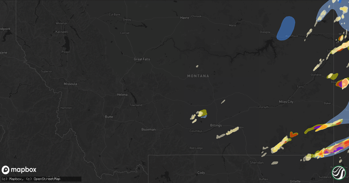
Hail Map in Montana on June 7, 2026
Get this storm
June 7 map
$229
one time, instant access
Download today. No call, no setup
Keep the $229
Bought the map and want the full workflow? Apply the entire $229 to a subscription within 7 days. None of it is wasted.
Every map, not just this one
This buys you this map. Subscription and you get every map we run, in the markets you choose from a few cities to whole states to nationwide. Plus real-time alerts the moment a storm fires.
Contact data
Name, contact info, occupancy, even credit band for addresses in the footprint. You go from where it hit to who to call.
Become the source they trust
Unlimited branding weather history reports on demand. You already have the documented answer ready for the property owner, and you are the one who showed up with it.
Property data and RoofTrace estimates
Pull up any address you have got, its value and the exact code rules for that jurisdiction, straight from One Click Code. Then RoofTrace estimates the squares, pitch, and roof value, priced the way you price.
Storm reports in Montana
Montana
| Date | Description |
|---|---|
| 06/07/20266:33 PM CDT | A local report indicates 66 MPH wind near 11 SSE Billings |
| 06/07/20266:00 PM CDT | Wofm8 mesonet observation site. |
| 06/07/20265:58 PM CDT | A local report indicates 3.00 inch wind near 9 N Belltower |
| 06/07/20265:49 PM CDT | A local report indicates 2.50 inch wind near 3 W Alzada |
| 06/07/20265:12 PM CDT | A local report indicates 3.00 inch wind near 16 ESE Powderville |
| 06/07/20264:30 PM CDT | A local report indicates 1.75 inch wind near 6 N Epsie |
| 06/07/20264:30 PM CDT | A local report indicates 1.75 inch wind near 2 SW Olive |
| 06/07/20264:24 PM CDT | A local report indicates 1.25 inch wind near 1 NNW Olive |
| 06/06/20268:12 PM CDT | Mtcom mesonet observation site. |
| 06/06/20268:00 PM CDT | Corrects previous tstm wnd gst report from 6 s comertown. Mtcom mesonet observation site. |
| 06/06/20268:00 PM CDT | Mesonet station mtbvr 3.8 ne hodges |
| 06/06/20267:15 PM CDT | Asos station kbhk baker. |
All States Impacted by Hail Map on June 7, 2026
Cities Impacted by Hail Map on June 7, 2026
- Roy, MT
- Hilger, MT
- Wickes, AR
- Grannis, AR
- Cove, AR
- Vandervoort, AR
- Owatonna, MN
- Ten Sleep, WY
- Manderson, WY
- Bonfield, IL
- Wilmington, IL
- Kankakee, IL
- Essex, IL
- Big Timber, MT
- Broadview, MT
- Lavina, MT
- Rapelje, MT
- Ryegate, MT
- Otter, MT
- Manteno, IL
- Reed Point, MT
- Bourbonnais, IL
- Dassel, MN
- Broadus, MT
- Olive, MT
- Hughesville, MO
- Sedalia, MO
- Marseilles, IL
- Sheridan, WY
- Decker, MT
- Birney, MT
- Biddle, MT
- Boyes, MT
- Moorcroft, WY
- Hulett, WY
- Alzada, MT
- Weston, WY
- Columbus, MT
- Wisner, NE
- Ekalaka, MT
- Hammond, MT
- Glenwood, MN
- Starbuck, MN
- West Plains, MO
- Moody, MO
- Billings, MT
- Lowry, MN
- Fairfield, ND
- Grassy Butte, ND
- Huntley, MT
- Musselshell, MT
- Roundup, MT
- Belle Fourche, SD
- Sentinel Butte, ND
- Beach, ND
- Buffalo, SD
- Elbow Lake, MN
- Ashby, MN
- Koshkonong, MO
- Lodge Grass, MT
- Killdeer, ND
- Camp Crook, SD
- Watford City, ND
- Medora, ND
- Wibaux, MT
- Peace Valley, MO
- Poplar, MT
- Fort Peck, MT
- Nashua, MT
- Frazer, MT
- Wolf Point, MT
- Peerless, MT
- Larslan, MT
- Savage, MT
- Brockton, MT
- Kaycee, WY
- Belfield, ND
- Arnegard, ND
- Sidney, MT
- Keene, ND
- Piggott, AR
- Crow Agency, MT
- Saint Xavier, MT
- Crane, MT
- Newell, SD
- Ludlow, SD
- Cartwright, ND
- Alexander, ND
- Hardin, MT
- Campbell, MO
- Saint Francis, AR
- Glendive, MT
- Reva, SD
- Highlandville, MO
- Baker, MT
- Rhame, ND
- Bowman, ND
- Williston, ND
- Dickinson, ND
- Reserve, MT
- New Town, ND
- Bloomfield, MT
- Medicine Lake, MT
- Springfield, MO
- Stanley, ND
- Ralph, SD
- Scranton, ND
- Amidon, ND
- Antelope, MT
- Plentywood, MT
- Manning, ND
- Reeder, ND
- Grenora, ND
- Mandaree, ND
- Prairie City, SD
- Lodgepole, SD
- Bison, SD
- Zahl, ND
- Epping, ND
- Gurley, NE
- Lemmon, SD
- Palermo, ND
- Halliday, ND
- Fortuna, ND
- Alamo, ND
- Ambrose, ND
- Westby, MT
- Ross, ND
- Regent, ND
- Tioga, ND
- Powers Lake, ND
- Hettinger, ND
- South Heart, ND
- New England, ND
- Mott, ND
- Homestead, MT
- Dagmar, MT
- Roseglen, ND
- Richardton, ND
- Dix, NE
- Dodge, ND
- Parshall, ND
- Potter, NE
- Kimball, NE
- Sherwood, ND
- White Earth, ND
- Wildrose, ND
- Mohall, ND
- Noonan, ND
- Mcgregor, ND
- Crosby, ND
- Donnybrook, ND
- Plaza, ND
- Flaxton, ND
- Columbus, ND
- Portal, ND
- Ray, ND
- Berthold, ND
- Kenmare, ND
- Tolley, ND
- Bowbells, ND
- Lignite, ND
- Carpio, ND
- Gladstone, ND
- Taylor, ND
- Makoti, ND
- Ryder, ND
- Zap, ND
- Garrison, ND
- Hebron, ND
- Golden Valley, ND
- Lansford, ND
- Lefor, ND
- Beulah, ND
- Dunn Center, ND
- Padroni, CO
- Selfridge, ND
- Des Lacs, ND
- Elgin, ND
- New Leipzig, ND
- Glen Ullin, ND
- Sparta, MO
- Seymour, MO
- Sidney, NE
- Clearmont, WY
- Peetz, CO
- Arvada, WY
- Ava, MO
- Burlington, ND
- New Salem, ND
- Hazen, ND
- Minot, ND
- Almont, ND
- Stanton, ND
- Douglas, ND
- Glenburn, ND
- Flasher, ND
- Carson, ND
- Raleigh, ND
- Center, ND
- Dalton, NE
- Broadwater, NE
- Riverdale, ND
- Underwood, ND
- Coleharbor, ND
- Turtle Lake, ND
- Norwich, ND
- Ruso, ND
- Washburn, ND
- Solen, ND
- Maxbass, ND
- Mandan, ND
- Sawyer, ND
- Deering, ND
- Max, ND
- Antler, ND
- Shields, ND
- Surrey, ND
- Velva, ND
- Saint Anthony, ND
- Benedict, ND
- Westhope, ND
- Minot Afb, ND
- Union Center, SD
- Sturgis, SD
- Rapid City, SD
- Fort Yates, ND
- Balfour, ND
- Cannon Ball, ND
- Linton, ND
- Kramer, ND
- Mcclusky, ND
- Granville, ND
- Newburg, ND
- Sterling, ND
- Baldwin, ND
- Moffit, ND
- Bismarck, ND
- Regan, ND
- Souris, ND
- Voltaire, ND
- Wilton, ND
- Towner, ND
- Butte, ND
- Menoken, ND
- Karlsruhe, ND
- Upham, ND
- Bantry, ND
- Mercer, ND
- Hazelton, ND
- Wing, ND
- Mud Butte, SD
- New Underwood, SD
- Faith, SD
- Meadow, SD
- Drake, ND
- Bottineau, ND
- Rugby, ND
- Denhoff, ND
- Willow City, ND
- Anamoose, ND
- Bridgeport, NE
- Dunseith, ND
- Martin, ND
- Driscoll, ND
- Tuttle, ND
- Goodrich, ND
- Balta, ND
- Hurdsfield, ND
- Harvey, ND
- Esmond, ND
- Rolette, ND
- Saint John, ND
- Belcourt, ND
- Rolla, ND
- Dupree, SD
- Maddock, ND
- Kansas, OK
- Watts, OK
- McIntosh, SD
- Colcord, OK
- Timber Lake, SD
- Glencross, SD
- McLaughlin, SD
- Isabel, SD
- Trail City, SD
- Braddock, ND
- Kintyre, ND
- Selby, SD
- Bayard, NE
- Angora, NE
- Lenapah, OK
- Wann, OK
- Parsons, KS
- Cherokee, KS
- Pittsburg, KS
- Hoven, SD
- S Coffeyville, OK
- Welch, OK
- Java, SD
- Chetopa, KS
- Scammon, KS
- McCune, KS
- West Mineral, KS
- Weir, KS
- Columbus, KS
- Bowdle, SD
- Coffeyville, KS
- Liberty, KS
- Thayer, KS
- Chanute, KS
- Independence, KS
- Galena, KS
- Erie, KS
- Galesburg, KS
- Oshkosh, NE
- Pollock, SD
- Wakpala, SD
- Mobridge, SD
- Glenham, SD
- Little Eagle, SD
- Herreid, SD
- Mound City, SD
- Saint Paul, KS
- Venango, NE
- Amherst, CO
- Greenfield, MO
- Grant, NE
- Lewellen, NE
- Miami, OK
- Neosho, MO
- Joplin, MO
- Edna, KS
- Mound Valley, KS
- Arthur, NE
- Quapaw, OK
- Picher, OK
- Altamont, KS
- Oswego, KS
- Baxter Springs, KS
- Diamond, MO
- Madrid, NE
- Bartlett, KS
- Elsie, NE
- Wallace, NE
- Big Springs, NE
- Goodman, MO
- Brule, NE
- Wyandotte, OK
- Granby, MO
- Stella, MO
- Rocky Comfort, MO
- Fairview, MO
- Ogallala, NE
- Dickens, NE
- Bluejacket, OK
- Dearing, KS
- Caney, KS
- Wheaton, MO
- Purdy, MO
- Exeter, MO
- Afton, OK
- Waubun, MN
- North Platte, NE
- Paxton, NE
- Arnold, NE
- Stapleton, NE
- Brady, NE
- South West City, MO
- Wolfforth, TX
- Lubbock, TX
- Ellsworth, NE
- Alliance, NE
- Jamestown, ND
- Jud, ND
- Pingree, ND
- Ellendale, ND
- Streeter, ND
- Lehr, ND
- Bowdon, ND
- Fessenden, ND
- Cathay, ND
- Roscoe, SD
- Medina, ND
- Forbes, ND
- Steele, ND
- Robinson, ND
- Hosmer, SD
- Montpelier, ND
- Ashley, ND
- Carrington, ND
- Sykeston, ND
- Tappen, ND
- Hague, ND
- Chaseley, ND
- Cleveland, ND
- Woodworth, ND
- Eagle Butte, SD
- Dawson, ND
- Eureka, SD
- Wishek, ND
- Buchanan, ND
- Strasburg, ND
- Long Lake, SD
- Pettibone, ND
- Gackle, ND
- Fredonia, ND
- Leola, SD
- Edgeley, ND
- Zeeland, ND
- Ipswich, SD
- Kulm, ND
- Napoleon, ND
- Whitehorse, SD
- Akaska, SD
- Tolstoy, SD
- Quinn, SD
- Kadoka, SD


