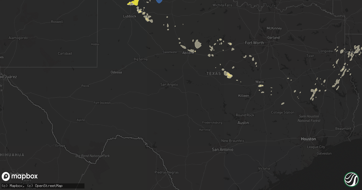
Hail Map in Texas on June 7, 2021
Get this storm
June 7 map
$229
one time, instant access
Download today. No call, no setup
Keep the $229
Bought the map and want the full workflow? Apply the entire $229 to a subscription within 7 days. None of it is wasted.
Every map, not just this one
This buys you this map. Subscription and you get every map we run, in the markets you choose from a few cities to whole states to nationwide. Plus real-time alerts the moment a storm fires.
Contact data
Name, contact info, occupancy, even credit band for addresses in the footprint. You go from where it hit to who to call.
Become the source they trust
Unlimited branding weather history reports on demand. You already have the documented answer ready for the property owner, and you are the one who showed up with it.
Property data and RoofTrace estimates
Pull up any address you have got, its value and the exact code rules for that jurisdiction, straight from One Click Code. Then RoofTrace estimates the squares, pitch, and roof value, priced the way you price.
Storm reports in Texas
Texas
| Date | Description |
|---|---|
| 06/07/20211:13 PM CDT | Tree down on cr 490 near laneville. |
| 06/07/20211:13 PM CDT | Pine tree down in 8500 block of sh 43. |
| 06/07/20211:12 PM CDT | Tree across us-259. |
| 06/07/20211:09 PM CDT | Tree down on cr4255. |
| 06/07/20211:08 PM CDT | Several trees blown down. |
| 06/07/202112:40 PM CDT | Several trees blown down in an rv park with one tree falling on and destroying an rv. |
| 06/07/20217:43 AM CDT | At 1243 AM CDT, severe thunderstorms were located along a line extending from 8 miles west of Brice to near Cone, moving northeast at 30 mph. HAZARD...60 mph wind gusts and quarter size hail. SOURCE...Radar indicated. IMPACT...Hail damage to vehicles is expected. Expect wind damage to roofs, siding, and trees. Locations impacted include... Floydada, Turkey, Caprock Canyon State Park, Lockney, Quitaque, Flomot, Valley Schools, South Plains, Dougherty, Lakeview and Plaska Community. |
| 06/07/20217:37 AM CDT | At 1236 PM CDT, severe thunderstorms were located along a line extending from near Mineola to 7 miles east of Palestine, moving east at 55 mph. HAZARD...60 mph wind gusts. SOURCE...Radar indicated. IMPACT...Expect damage to roofs, siding, and trees. Locations impacted include... Tyler, Longview, Jacksonville, Henderson, Kilgore, Whitehouse, White Oak, Gladewater, Rusk, Gilmer, Mineola, Lindale, Overton, Bullard, Troup, Big Sandy, Hawkins, Alto, New London and Berryville. |
| 06/07/20217:35 AM CDT | At 1234 AM CDT, a severe thunderstorm was located 13 miles northwest of Gail, moving east at 30 mph. HAZARD...60 mph wind gusts and quarter size hail. SOURCE...Radar indicated. IMPACT...Hail damage to vehicles is expected. Expect wind damage to roofs, siding, and trees. Locations impacted include... Gail and Fluvanna. |
| 06/07/20217:15 AM CDT | At 1215 AM CDT, a severe thunderstorm was located 5 miles southeast of Tahoka, moving east at 15 mph. HAZARD...60 mph wind gusts and quarter size hail. SOURCE...Radar indicated. IMPACT...Hail damage to vehicles is expected. Expect wind damage to roofs, siding, and trees. Locations impacted include... Tahoka and Grassland. |
| 06/07/20216:29 AM CDT | At 1129 PM CDT, a severe thunderstorm was located 14 miles west of Brice, or 16 miles southwest of Clarendon, moving east at 20 mph. HAZARD...60 mph wind gusts and quarter size hail. SOURCE...Radar indicated. IMPACT...Minor damage to roofs, siding, and trees is possible. Hail damage to vehicles is expected. This severe thunderstorm will remain over mainly rural areas of southeastern Armstrong and southwestern Donley Counties. |
| 06/07/20216:25 AM CDT | At 1125 PM CDT, severe thunderstorms were located along a line extending from 4 miles west of South Plains to 8 miles south of Aiken to 5 miles northwest of Abernathy, moving southeast at 25 mph. HAZARD...60 mph wind gusts and quarter size hail. SOURCE...Radar indicated. IMPACT...Hail damage to vehicles is expected. Expect wind damage to roofs, siding, and trees. Locations impacted include... Floydada, Abernathy, Lockney, Petersburg, Lorenzo, Flomot, Cone, South Plains, Dougherty and Aiken. |
| 06/07/20216:07 AM CDT | At 1106 PM CDT, a severe thunderstorm was located 6 miles north of Aiken, or 11 miles east of Plainview, moving east at 15 mph. HAZARD...60 mph wind gusts and quarter size hail. SOURCE...Radar indicated. IMPACT...Hail damage to vehicles is expected. Expect wind damage to roofs, siding, and trees. Locations impacted include... Plainview, Floydada, Lockney, Aiken, South Plains and Seth Ward. |
| 06/07/20215:29 AM CDT | At 1029 PM CDT, a severe thunderstorm was located 5 miles northwest of Claytonville, or 11 miles southeast of Tulia, moving east at 10 mph. HAZARD...60 mph wind gusts and quarter size hail. SOURCE...Radar indicated. IMPACT...Hail damage to vehicles is expected. Expect wind damage to roofs, siding, and trees. Locations impacted include... Silverton, Mackenzie Reservoir and Claytonville. |
| 06/07/20214:18 AM CDT | At 918 PM CDT, a severe thunderstorm was located near Oklahoma Lane, or 10 miles northwest of Muleshoe, moving east at 10 mph. HAZARD...60 mph wind gusts and quarter size hail. SOURCE...Radar indicated. IMPACT...Hail damage to vehicles is expected. Expect wind damage to roofs, siding, and trees. Locations impacted include... Muleshoe, Lazbuddie, Oklahoma Lane and Progress. |
| 06/07/20213:30 AM CDT | At 830 PM CDT, a severe thunderstorm was located 4 miles southeast of Friona, moving northeast at 15 mph. HAZARD...60 mph wind gusts and quarter size hail. SOURCE...Radar indicated. IMPACT...Hail damage to vehicles is expected. Expect wind damage to roofs, siding, and trees. Locations impacted include... Friona, Summerfield, Easter and Black. |
| 06/07/20213:23 AM CDT | At 823 PM CDT, a severe thunderstorm was located or 8 miles west of Hereford, moving southeast at 20 mph. HAZARD...60 mph wind gusts and quarter size hail. SOURCE...Radar indicated. IMPACT...Minor damage to roofs, siding, and trees is possible. Hail damage to vehicles is expected. Locations impacted include... Hereford. |
| 06/06/202111:10 PM CDT | At 410 AM CDT, severe thunderstorms were located along a line extending from 4 miles west of Chattanooga to near Loveland to 4 miles east of Davidson, moving southeast at 35 mph. HAZARD...Golf ball size hail and 70 mph wind gusts. SOURCE...Radar indicated. IMPACT...People and animals outdoors will be injured. Expect hail damage to roofs, siding, windows, and vehicles. Expect considerable tree damage. Wind damage is also likely to mobile homes, roofs, and outbuildings. Locations impacted include... Frederick, Grandfield, Chattanooga, Randlett, Davidson, Devol, Hollister, Loveland, Cookietown and Taylor. |
| 06/06/202110:30 PM CDT | At 330 AM CDT, severe thunderstorms were located along a line extending from 8 miles south of Snyder to near Manitou, moving south at 30 mph. HAZARD...70 mph wind gusts and quarter size hail. SOURCE...Radar indicated. IMPACT...Hail damage to vehicles is expected. Expect considerable tree damage. Wind damage is also likely to mobile homes, roofs, and outbuildings. Locations impacted include... Frederick, Snyder, Grandfield, Tipton, Chattanooga, Davidson, Manitou, Hollister and Loveland. |
| 06/06/202110:25 PM CDT | At 325 AM CDT, severe thunderstorms were located along a line extending from 4 miles west of Medicine Mound to 8 miles north of Gilliland, moving east at 10 mph. HAZARD...60 mph wind gusts and quarter size hail. SOURCE...Radar indicated. IMPACT...Hail damage to vehicles is expected. Expect wind damage to roofs, siding, and trees. Locations impacted include... Vernon, Crowell, Margaret, Lockett, Thalia, Rayland and Copper Breaks State Park. |
| 06/06/202110:19 PM CDT | At 319 AM CDT, severe thunderstorms were located along a line extending from 10 miles west of Odell to 5 miles southwest of Eldorado, moving southeast at 15 mph. HAZARD...60 mph wind gusts and quarter size hail. SOURCE...Radar indicated. IMPACT...Hail damage to vehicles is expected. Expect wind damage to roofs, siding, and trees. Locations impacted include... Quanah, Chillicothe, Eldorado, Odell and Medicine Mound. |
| 06/06/202110:08 PM CDT | At 308 AM CDT, severe thunderstorms were located along a line extending from 8 miles southwest of Truscott to 10 miles northwest of Knox City, moving east at 30 mph. HAZARD...60 mph wind gusts and quarter size hail. SOURCE...Radar indicated. IMPACT...Hail damage to vehicles is expected. Expect wind damage to roofs, siding, and trees. Locations impacted include... Munday, Benjamin, Goree, Red Springs, Vera, Truscott, Gilliland, Rhineland and Bomarton. |
| 06/06/202110:07 PM CDT | 60 mph wind gust at the wtm site at umbarger. Occurred in light rain. |
| 06/06/202110:01 PM CDT | At 301 AM CDT, a severe thunderstorm was located 10 miles northeast of Aspermont, moving east at 10 mph. HAZARD...Ping pong ball size hail. SOURCE...Radar indicated. IMPACT...People and animals outdoors will be injured. Expect damage to roofs, siding, windows, and vehicles. Locations impacted include... Old Glory and Us-380 Near The Haskell-Stonewall County Line. |
| 06/06/20219:28 PM CDT | At 227 AM CDT, a severe thunderstorm was located over Guthrie, moving northeast at 25 mph. A second severe storm was located along highway 114 near the King and Dickens county line. HAZARD...60 mph wind gusts and half dollar size hail. SOURCE...Radar indicated. IMPACT...Hail damage to vehicles is expected. Expect wind damage to roofs, siding, and trees. Locations impacted include... Guthrie, Finney and Grow. |
| 06/06/20218:55 PM CDT | Measured by the ttu mesonet |
| 06/06/20218:53 PM CDT | At 152 AM CDT, a severe thunderstorm was located near Dickens, moving southeast at 25 mph. HAZARD...Ping pong ball size hail and 60 mph wind gusts. SOURCE...Radar indicated. IMPACT...People and animals outdoors will be injured. Expect hail damage to roofs, siding, windows, and vehicles. Expect wind damage to roofs, siding, and trees. Locations impacted include... Spur, Dickens and Afton. |
| 06/06/20218:30 PM CDT | Ham radio tower blown down. Time estimated from radar. |
| 06/06/20218:26 PM CDT | At 126 AM CDT, a severe thunderstorm was located 9 miles west of Fluvanna, or 11 miles northeast of Gail, moving east at 30 mph. HAZARD...60 mph wind gusts and quarter size hail. SOURCE...Radar indicated. IMPACT...Hail damage to vehicles is expected. Expect wind damage to roofs, siding, and trees. Locations impacted include... Snyder and Fluvanna. |
All States Impacted by Hail Map on June 7, 2021
Cities Impacted by Hail Map on June 7, 2021
- Cook, MN
- Bryan, TX
- Hearne, TX
- Carr, CO
- Uniontown, AL
- Marion, AL
- Summerfield, TX
- Hereford, TX
- Fergus Falls, MN
- Fredonia, ND
- Wishek, ND
- Lehr, ND
- Ashley, ND
- Hawley, MN
- Strawn, TX
- Graford, TX
- Comanche, TX
- Gustine, TX
- Dublin, TX
- Fort Lupton, CO
- Longmont, CO
- Platteville, CO
- Mineral Wells, TX
- Dickey, ND
- Jud, ND
- Marion, ND
- Litchville, ND
- Montpelier, ND
- Fort Collins, CO
- Clyde, TX
- Kulm, ND
- Lamoure, ND
- Grygla, MN
- Wirt, MN
- Squaw Lake, MN
- Northome, MN
- Max, MN
- Blackduck, MN
- Beardstown, IL
- Bigfork, MN
- Nashwauk, MN
- Bovey, MN
- Side Lake, MN
- Caddo, TX
- Calhoun, LA
- Choudrant, LA
- Park Rapids, MN
- Friona, TX
- Saline, LA
- Bienville, LA
- Jonesboro, LA
- Lutsen, MN
- Floydada, TX
- Hitterdal, MN
- Glyndon, MN
- Lead, SD
- Hill City, SD
- Abernathy, TX
- Angora, MN
- Kosciusko, MS
- Ethel, MS
- Forbes, MN
- Greensboro, AL
- Moundville, AL
- Dimmitt, TX
- Fort Ransom, ND
- Marks, MS
- Vance, MS
- Lambert, MS
- Big Falls, MN
- Breckenridge, TX
- Jamestown, ND
- Enderlin, ND
- Ralls, TX
- Zeeland, ND
- Eureka, SD
- Rochester, TX
- Pollok, TX
- Claude, TX
- Blum, TX
- Hillsboro, TX
- Covington, TX
- West, MS
- Nacogdoches, TX
- Walcott, ND
- Port Gibson, MS
- Lorman, MS
- Paducah, TX
- Haughton, LA
- Doyline, LA
- Mapleton, ND
- Davenport, ND
- Nunn, CO
- Pierce, CO
- Streeter, ND
- Gackle, ND
- Cleburne, TX
- Godley, TX
- Lufkin, TX
- Apple Springs, TX
- Glenham, SD
- Mound City, SD
- Plainview, TX
- Lipan, TX
- Santo, TX
- Climax, MN
- Crookston, MN
- Chidester, AR
- Gloster, LA
- Stonewall, LA
- Shreveport, LA
- Keithville, LA
- Gary, TX
- Carthage, TX
- Edgeley, ND
- Mizpah, MN
- Lisbon, ND
- Ellendale, ND
- Embarrass, MN
- Simsboro, LA
- Quitman, LA
- Berlin, ND
- Effie, MN
- Long Lake, SD
- Grady, AR
- Hamlin, TX
- Centerville, TX
- Waskom, TX
- Wakpala, SD
- Java, SD
- Selby, SD
- Herreid, SD
- Pollock, SD
- Timnath, CO
- Windsor, CO
- Groveton, TX
- Waco, TX
- Lorena, TX
- Carthage, MS
- Joaquin, TX
- Bastrop, LA
- Silverton, TX
- Ypsilanti, ND
- Kathryn, ND
- Tulia, TX
- Whitney, TX
- Wimbledon, ND
- Nome, ND
- Hague, ND
- Linton, ND
- Sheldon, ND
- Leonard, ND
- Pingree, ND
- Buchanan, ND
- Cleveland, ND
- Kintyre, ND
- Napoleon, ND
- Gwinner, ND
- Milnor, ND
- Courtenay, ND
- Medina, ND
- Kensal, ND
- Verona, ND
- Fairburn, SD
- Bremond, TX
- Farwell, TX
- Muleshoe, TX
- Converse, LA
- Shelbyville, TX
- Reynolds, ND
- Backus, MN
- Deer Trail, CO
- Kosse, TX
- Mountain Iron, MN
- Aspermont, TX
- McCool, MS
- New Edinburg, AR
- Marshall, TX
- Carlton, TX
- Hamilton, TX
- Pottsville, TX
- Palo Pinto, TX
- Chisholm, MN
- Albany, TX
- Karnack, TX
- Edwards, MS
- Mansfield, LA
- Nazareth, TX
- Ault, CO
- Lorenzo, TX
- Nashville, AR
- Minden, LA
- Oral, SD
- Hannaford, ND
- Kress, TX
- Philadelphia, MS
- Anson, TX
- Merkel, TX
- Hawley, TX
- Marion Junction, AL
- Britt, MN
- Wheatland, ND
- Jay Em, WY
- Earth, TX
- Petersburg, TX
- Lockney, TX
- Detroit Lakes, MN
- Audubon, MN
- Kirby, AR
- Bangor, PA
- Pen Argyl, PA
- Tiskilwa, IL
- Buda, IL
- Keatchie, LA
- Logansport, LA
- Eastland, TX
- Cisco, TX
- Lott, TX
- Bishop, GA
- Lueders, TX
- Kennard, TX
- Pennington, TX
- Trinity, TX
- Natchez, MS
- Bradford, IL
- Quitman, MS
- Moorhead, MN
- El Dorado, AR
- Douglas, WY
- Forest, MS
- Midway, TX
- Fullerton, ND
- Spur, TX
- Crosbyton, TX
- Walnut Grove, MS
- Alto, TX
- Chireno, TX
- Etoile, TX
- San Augustine, TX
- Hoyt Lakes, MN
- De Leon, TX
- Hale Center, TX
- Canton, MS
- Brandon, MS
- Madison, MS
- Center, TX
- Orr, MN
- Lake Park, MN
- Montrose, AR
- Pelican Rapids, MN
- Princeton, LA
- Hamburg, AR
- Abilene, TX
- Annawan, IL
- Dermott, AR
- Wisner, LA
- Gilbert, LA
- Jonesboro, TX
- Eros, LA
- Rio Vista, TX
- Fingal, ND
- Oriska, ND
- Goodridge, MN
- Meadowlands, MN
- Hibbing, MN
- Granbury, TX
- Rainbow, TX
- Chatham, LA
- Middle River, MN
- Valley City, ND
- Sallis, MS
- Lillie, LA
- Chilton, TX
- Eveleth, MN
- Kindred, ND
- Horace, ND
- Valliant, OK
- Ruston, LA
- New Milford, CT
- McNeil, AR
- Vaiden, MS
- Kilmichael, MS
- Hico, TX
- Strasburg, ND
- Buffalo Gap, SD
- Elm Grove, LA
- Crockett, TX
- Fayette, MS
- Gatesville, TX
- Idalou, TX
- Bossier City, LA
- Barksdale Afb, LA
- Benton, LA
- Lyons, KS
- Mineral Springs, AR
- Irmo, SC
- Eddy, TX
- Birmingham, AL
- Williams, MN
- New Canton, IL
- Mooringsport, LA
- Nevis, MN
- Homer, LA
- Diboll, TX
- Brierfield, AL
- Centreville, AL
- Jayton, TX
- Douglass, TX
- Cooperstown, ND
- Smackover, AR
- Louann, AR
- Lance Creek, WY
- Lusk, WY
- Broaddus, TX
- Chapin, SC
- Milan, IL
- Oakwood, TX
- Mingus, TX
- Fairfield, TX
- Buffalo, TX
- Christine, ND
- West Fargo, ND
- Rothsay, MN
- Erhard, MN
- Wahpeton, ND
- Wolverton, MN
- Fargo, ND
- Elizabeth, MN
- Colfax, ND
- Kent, MN
- Abercrombie, ND
- Comstock, MN
- Foxhome, MN
- Breckenridge, MN
- Vergas, MN
- Perham, MN
- Barnesville, MN
- Dent, MN
- Frazee, MN
- Hatton, ND
- Turkey, TX
- Flomot, TX
- Matador, TX
- Quitaque, TX


