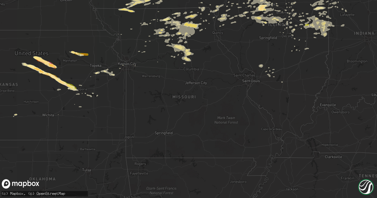
Hail Map in Missouri on June 7, 2015
Get this storm
June 7 map
$229
one time, instant access
Download today. No call, no setup
Keep the $229
Bought the map and want the full workflow? Apply the entire $229 to a subscription within 7 days. None of it is wasted.
Every map, not just this one
This buys you this map. Subscription and you get every map we run, in the markets you choose from a few cities to whole states to nationwide. Plus real-time alerts the moment a storm fires.
Contact data
Name, contact info, occupancy, even credit band for addresses in the footprint. You go from where it hit to who to call.
Become the source they trust
Unlimited branding weather history reports on demand. You already have the documented answer ready for the property owner, and you are the one who showed up with it.
Property data and RoofTrace estimates
Pull up any address you have got, its value and the exact code rules for that jurisdiction, straight from One Click Code. Then RoofTrace estimates the squares, pitch, and roof value, priced the way you price.
Storm reports in Missouri
Missouri
| Date | Description |
|---|---|
| 06/07/20156:10 PM CDT | Estimated 50 to 60 mph. Torrential rain with visibility less than 100 feet. |
| 06/07/20156:05 PM CDT | 5 inch diameter tree limb blown down |
| 06/07/20155:56 PM CDT | A local report indicates 1.00 inch wind near NW GILMAN CITY |
| 06/07/20155:34 PM CDT | A local report indicates 60 MPH wind near LIVONIA |
| 06/07/20155:25 PM CDT | A local report indicates 1.00 inch wind near 7 NNW MILAN |
| 06/07/20154:01 PM CDT | Estimated 50 mph winds and heavy rain. Small limbs down and leaves coming off trees. |
| 06/06/20159:44 PM CDT | Occurred with torrential rain. |
| 06/06/20159:14 PM CDT | 60 to 70 mph estimated. Delayed report with time also estimated from radar. |
All States Impacted by Hail Map on June 7, 2015
Cities Impacted by Hail Map on June 7, 2015
- Westmoreland, KS
- West Point, IA
- Donnellson, IA
- Fort Madison, IA
- Ransom, IL
- Santa Rosa, NM
- Hanna City, IL
- Glasford, IL
- Crookston, MN
- Buckley, IL
- Cissna Park, IL
- Milford, IL
- Crown Point, IN
- Lowell, IN
- Hebron, IN
- Balko, OK
- Beaver, OK
- Bedford, IA
- Blockton, IA
- Manteno, IL
- Grant Park, IL
- Tescott, KS
- Salina, KS
- Hopkins, MO
- Sheridan, MO
- Lincoln, KS
- Beverly, KS
- Gilman City, MO
- Kirksville, MO
- Hurdland, MO
- Novelty, MO
- Edina, MO
- Gibbs, MO
- Brashear, MO
- Keytesville, MO
- Salisbury, MO
- Clifton Hill, MO
- Hooker, OK
- Fertile, MN
- Bejou, MN
- Karlstad, MN
- Green City, MO
- Milan, MO
- Akeley, MN
- Table Grove, IL
- Marietta, IL
- Linneus, MO
- Mooreland, OK
- Fargo, OK
- Wheeling, MO
- Chula, MO
- Hendricks, MN
- Ivanhoe, MN
- Hugoton, KS
- Atlanta, IL
- Sullivan, IL
- Olsburg, KS
- Onaga, KS
- Peoria, IL
- Edwards, IL
- Hamilton, MO
- Pierre, SD
- Blunt, SD
- Perryton, TX
- Alvarado, MN
- Argyle, MN
- Warren, MN
- East Grand Forks, MN
- Minto, ND
- Lehigh Acres, FL
- Pritchett, CO
- Luray, MO
- North Platte, NE
- Wellfleet, NE
- North Branch, MN
- Stronghurst, IL
- Carman, IL
- Saint Thomas, ND
- Drayton, ND
- Coloma, MI
- La Plata, MO
- Goodwell, OK
- Turpin, OK
- Guymon, OK
- Hardesty, OK
- Sandoval, IL
- Centralia, IL
- Argyle, IA
- Wayland, MO
- Pembina, ND
- Dalhart, TX
- Mentor, MN
- Red Lake Falls, MN
- Sutherland, NE
- Keystone, NE
- Hershey, NE
- Paxton, NE
- Newark, MO
- Lawrence, MI
- Hartford, MI
- Chenoa, IL
- Moscow, KS
- Fithian, IL
- Armstrong, IL
- Springer, NM
- Grant City, MO
- Cavalier, ND
- Kadoka, SD
- Parks, NE
- Benkelman, NE
- Delphos, KS
- Canton, IL
- Manito, IL
- Trivoli, IL
- Mapleton, IL
- West Point, IL
- Warsaw, IL
- Carthage, IL
- Basco, IL
- Windsor, IL
- Winamac, IN
- Medaryville, IN
- McLean, IL
- Holyoke, CO
- Fairmount, IL
- Shevlin, MN
- Gilson, IL
- Pillager, MN
- Huntsville, MO
- Moberly, MO
- Higbee, MO
- Laverne, OK
- May, OK
- Badger, MN
- Reddick, IL
- Herscher, IL
- Dwight, IL
- Bonfield, IL
- Buckingham, IL
- Gardner, IL
- Odell, IL
- Union Hill, IL
- Beltrami, MN
- Clovis, NM
- Mcalister, NM
- Industry, IL
- Adair, IL
- Macomb, IL
- Spickard, MO
- Follett, TX
- Lagrange, WY
- Sidell, IL
- Longview, IL
- Allerton, IL
- Broadlands, IL
- Novinger, MO
- Green Castle, MO
- Kingston Mines, IL
- Farmington, IL
- North Judson, IN
- Kouts, IN
- Wheatfield, IN
- La Crosse, IN
- San Pierre, IN
- Mahnomen, MN
- Yates City, IL
- Brimfield, IL
- Elmwood, IL
- La Loma, NM
- Buffalo, OK
- Corydon, IA
- Chariton, IA
- Humeston, IA
- Russell, IA
- Ethel, MO
- Mendon, IL
- Loraine, IL
- Saint Joseph, IL
- Memphis, MO
- Downing, MO
- Greentop, MO
- Queen City, MO
- Rutledge, MO
- Lost Springs, KS
- Strong City, KS
- Wilsey, KS
- Herington, KS
- Burdick, KS
- Maroa, IL
- Lewistown, MO
- Hensel, ND
- Rankin, IL
- Rossville, IL
- Hoopeston, IL
- Gravity, IA
- Corning, IA
- Lenox, IA
- Argenta, IL
- Earl Park, IN
- Fowler, IN
- Topeka, IL
- Lewistown, IL
- Havana, IL
- Easton, IL
- Chillicothe, MO
- Browning, MO
- Laredo, MO
- Trenton, MO
- Purdin, MO
- Humphreys, MO
- Cooksville, IL
- Lewellen, NE
- Tucumcari, NM
- Mekinock, ND
- Grand Forks, ND
- Elmer, MO
- Brainerd, MN
- West Lafayette, IN
- Brookston, IN
- Harris, MO
- Newtown, MO
- Pollock, MO
- Remington, IN
- Goodland, IN
- Princeville, IL
- Williamsfield, IL
- Beaverville, IL
- Cayuga, IN
- Ridge Farm, IL
- Ludlow, IL
- Penfield, IL
- Williamsport, IN
- Ogden, IL
- Metcalf, IL
- Chrisman, IL
- Tilton, IL
- Homer, IL
- Oakwood, IL
- Gifford, IL
- Danville, IL
- Savoy, IL
- Bismarck, IL
- Rantoul, IL
- Royal, IL
- Dewey, IL
- State Line, IN
- Urbana, IL
- Perrysville, IN
- Georgetown, IL
- Westville, IL
- Champaign, IL
- Bondville, IL
- Thomasboro, IL
- Indianola, IL
- Catlin, IL
- Muncie, IL
- Potomac, IL
- Covington, IN
- Collison, IL
- Veedersburg, IN
- Burlington, KS
- Harrisburg, MO
- Clark, MO
- Donaldson, MN
- Beecher, IL
- Cimarron, NM
- Wanblee, SD
- Kennedy, MN
- Ogallala, NE
- Campo, CO
- Abilene, KS
- Letcher, SD
- Wilmington, IL
- Solomon, KS
- Wamego, KS
- Belvue, KS
- Amherst, CO
- Cisco, IL
- Cullom, IL
- Roseau, MN
- Breckenridge, MO
- Fayette, MO
- Edwardsville, IL
- Cantril, IA
- Arbela, MO
- Grand Ridge, IL
- Streator, IL
- Browerville, MN
- Randall, MN
- Little Falls, MN
- Cushing, MN
- Augusta, KS
- Staples, MN
- Independence, MO
- Carbondale, KS
- Berryton, KS
- Livonia, MO
- Bennett, CO
- Fair Oaks, IN
- Rensselaer, IN
- Morocco, IN
- Savannah, MO
- Amazonia, MO
- Bemidji, MN
- Fairview, IL
- Van Wert, IA
- Leon, IA
- Decatur, IA
- Grand River, IA
- Weldon, IA
- Emden, IL
- Hamilton, IL
- Elvaston, IL
- Sutter, IL
- Bowen, IL
- Mason City, IL
- Overbrook, KS
- Melrose, IA
- Sorento, IL
- Cerro Gordo, IL
- Decatur, IL
- Grady, NM
- San Jon, NM
- Hartsburg, IL
- Princeton, IL
- Atkinson, IL
- Geneseo, IL
- Cedar Lake, IN
- Monmouth, IL
- Cameron, IL
- Lawrence, KS
- Cunningham, KS
- La Harpe, IL
- Dallas City, IL
- Utica, IL
- Ottawa, IL
- Ollie, IA
- Packwood, IA
- Cuervo, NM
- Saybrook, IL
- Bellflower, IL
- Booker, TX
- Peotone, IL
- Strandquist, MN
- Bunker Hill, IL
- Staunton, IL
- Malden, IL
- Arlington, IL
- Ohio, IL
- Dover, IL
- Lawson, MO
- Canadian, TX
- Presho, SD
- Hopedale, IL
- Delavan, IL
- Benton, IA
- Mount Ayr, IA
- Diagonal, IA
- Flanagan, IL
- Minonk, IL
- Shattuck, OK
- Hamilton, ND
- Manvel, ND
- Minneapolis, KS
- Talmage, KS
- Longford, KS
- Avon, IL
- Lamoni, IA
- Rayville, MO
- Lomax, IL
- Raritan, IL
- Marion, KS
- Sheldon, IL
- Kentland, IN
- Eureka, KS
- Galesburg, IL
- Fort Ripley, MN
- Downs, IL
- Wapella, IL
- Mansfield, IL
- Mahomet, IL
- Fisher, IL
- Arrowsmith, IL
- Crook, CO
- Sidney, NE
- Unionville, MO
- Batavia, IA
- Selma, IA
- Douds, IA
- Birmingham, IA
- Libertyville, IA
- Ellisville, IL
- Sturgeon, MO
- Wyoming, IL
- Bradford, IL
- Toulon, IL
- Glasgow, MO
- Minneota, MN
- Albia, IA
- Moravia, IA
- Fort Myers, FL
- Crete, IL
- Bloomington, IL
- Pekin, IL
- Grygla, MN
- Princeton, MO
- Plymouth, IL
- Colchester, IL
- Montrose, IA
- Tampico, IL
- Prophetstown, IL
- Armington, IL
- Greenview, IL
- Ipava, IL
- Waynesville, IL
- Shirley, IL
- Kilbourne, IL
- Heyworth, IL
- San Jose, IL
- Lincoln, IL
- Green Valley, IL
- New Holland, IL
- Forest City, IL
- Towanda, IL
- Stephen, MN
- Hope, KS
- New Cambria, KS
- West Lebanon, IN
- Charleston, IL
- Mattoon, IL
- Alexandria, MO
- Clearfield, IA
- Shannon City, IA
- Redding, IA
- Sharpsburg, IA
- Kellerton, IA
- Tingley, IA
- Las Vegas, NM
- Fairfield, IA
- Wellington, IL
- Mount Sterling, IA
- Spearman, TX
- Gruver, TX
- Hedrick, IA
- Ottumwa, IA
- Hackensack, MN
- Pattonsburg, MO
- Coffey, MO
- Bethany, MO
- Demotte, IN
- Lake Village, IN
- Berwick, IL
- Brookfield, MO
- Marceline, MO
- Kansas City, KS
- Park Rapids, MN
- De Land, IL
- Lostant, IL
- Emmett, KS
- Mediapolis, IA
- Sperry, IA
- Oquawka, IL
- Burlington, IA
- Oakville, IA
- Blakesburg, IA
- Maysville, MO
- King City, MO
- Lancaster, MO
- Slater, MO
- Gilliam, MO
- Rocheport, MO
- Richmond, MO
- Williamstown, MO
- Kahoka, MO
- Bucklin, MO
- Turon, KS
- Roberts, IL
- Thawville, IL
- Arcola, IL
- Pierz, MN
- Clifton, IL
- Augusta, IL
- Huntsville, IL
- Bourbonnais, IL
- Kankakee, IL
- Grafton, ND
- Oslo, MN
- Winigan, MO
- Watervliet, MI
- Lemoyne, NE
- Brule, NE
- Nauvoo, IL
- Gibson City, IL
- Darrouzett, TX
- Vermont, IL
- Bayard, NE
- Atlanta, MO
- Bevier, MO
- Macon, MO
- Shelbyville, IL
- Annawan, IL
- Buda, IL
- Newman, IL
- Emporia, KS
- Cottonwood Falls, KS
- Gypsum, KS
- Clinton, IL
- Sparland, IL
- Strasburg, CO
- Greenbush, MN
- Lenexa, KS
- Tonica, IL
- Menahga, MN
- Callao, MO
- Rothville, MO
- Armstrong, MO
- Cairo, MO
- Madison, MO
- Mendon, MO
- Warrensburg, IL
- Hillman, MN
- Donovan, IL
- Dahinda, IL
- Dewitt, IL
- Mercer, MO
- Kenney, IL
- Fort Pierre, SD
- Miller, SD
- Wessington, SD
- Hamilton, KS
- Unionville, IA
- Drakesville, IA
- Worthington, MO
- Le Roy, IL
- Brook, IN
- Garden Grove, IA
- Knox City, MO
- New Boston, MO
- Galt, MO
- Baring, MO
- Anabel, MO
- Leonard, MO
- Wray, CO
- Hartford, KS
- Francesville, IN
- Mystic, IA
- Varna, IL
- Magnolia, IL
- Lacon, IL
- Keokuk, IA
- Wever, IA
- Miltonvale, KS
- Chapman, KS
- Alhambra, IL
- New Douglas, IL
- Foosland, IL
- Eureka, IL
- Washington, IL
- Americus, KS
- Baldwin City, KS
- Edgerton, KS
- Eudora, KS
- Wellsville, KS
- Lovington, IL
- Ellsworth, IL
- El Paso, IL
- Kempton, IL
- Chebanse, IL
- Fairbury, IL
- Pontiac, IL
- Ashkum, IL
- Forrest, IL
- Cabery, IL
- Saunemin, IL
- Emington, IL
- Putnam, IL
- Hennepin, IL
- Pocahontas, IL
- Highland, IL
- Fort Supply, OK
- Richland, IA
- Kim, CO
- New Cambria, MO
- Danvers, IL
- Greenville, IL
- Watseka, IL
- Millerton, IA
- Plano, IA
- Woodburn, IA
- Ellston, IA
- Allerton, IA
- Promise City, IA
- Onamia, MN
- Blue Springs, MO
- Speer, IL
- Iroquois, SD
- Monticello, IL
- White Heath, IL
- Schneider, IN
- Momence, IL
- Pembroke Township, IL
- Marseilles, IL
- Cowgill, MO
- Saint Augustine, IL
- London Mills, IL
- Maquon, IL
- Abingdon, IL
- Mackinaw, IL
- Tremont, IL
- Martinton, IL
- Carlyle, IL
- Crescent City, IL
- Gilman, IL
- Onarga, IL
- Hudson, IL
- Bruce, SD
- Paxton, IL
- Bennington, KS
- Seymour, IL
- La Belle, MO
- Lancaster, MN
- Olpe, KS
- Lowpoint, IL
- Monee, IL
- Normal, IL
- Oreana, IL
- Sumner, MO
- Laclede, MO
- Euclid, MN
- Meadville, MO
- Walker, MN
- Derby, IA
- Lebo, KS
- Hallock, MN
- Goodridge, MN
- Arthur, IL
- Sedgwick, CO
- Haxtun, CO
- East Peoria, IL
- Morton, IL
- Gridley, IL
- Floris, IA
- Bloomfield, IA
- Eldon, IA
- Deer Creek, IL
- Ramona, KS
- Mount Pulaski, IL
- Burlingame, KS
- Harrold, SD
- Chillicothe, IL
- Edelstein, IL
- Gorin, MO
- Monon, IN
- Wolcott, IN
- Merrillville, IN
- Excello, MO
- Bathgate, ND
- Saint Joseph, MO
- Laporte, MN
- Smithshire, IL
- Roseville, IL
- Lexington, IL
- Lock Springs, MO
- Alma, MO
- Keosauqua, IA
- Good Hope, IL
- Sciota, IL
- Loda, IL
- South Pekin, IL
- Cuba, IL
- Laura, IL
- Peoria Heights, IL
- Bryant, IL
- Dunlap, IL
- Creve Coeur, IL
- Groveland, IL
- Monticello, MO
- Gillespie, IL
- Wilsonville, IL
- Worden, IL
- Weldon, IL
- Cornell, IL
- Campus, IL
- University Park, IL
- Steger, IL
- Dyer, IN
- Saint John, IN
- Kinsman, IL
- Schererville, IN
- Essex, IL
- Chicago Heights, IL
- Gardner, KS
- Ghent, MN
- Marshall, MN
- Smithfield, IL
- Crawfordsville, IN
- New Richmond, IN
- Waynetown, IN
- Wingate, IN
- Neche, ND
- Covert, MI
- Saint Vincent, MN
- Delia, KS
- Havensville, KS
- Council Grove, KS


